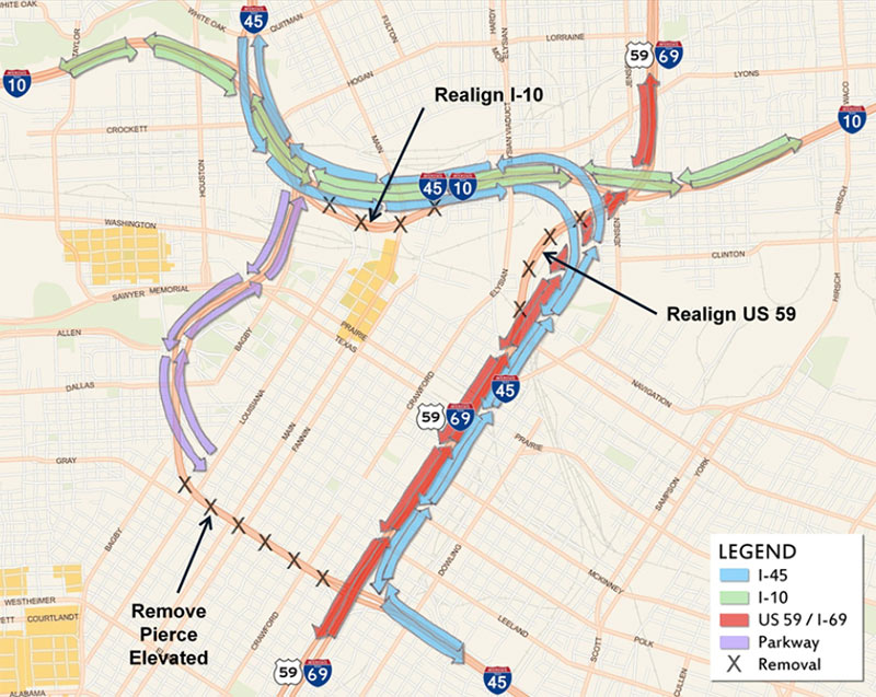
There’s so much to talk about and gawk at in the latest “proposed recommended alternatives” for reshaping I-45 now being shopped around by TxDOT and a host of freeway-happy consultants — enough for a fourth round of public meetings scheduled for tonight and next week, plus hours of extra-curricular speculation. The plans encompass dramatic changes to the North Freeway all the way from Beltway 8 to a new split adjacent to the Third Ward, including eye-opening widenings, all sorts of exciting tunnels and high-flying overpasses, a slew of spaghetti-like interchanges, and — the pièce de résistance — the wholesale give-up of I-45’s current L-shaped wrap around Downtown, including the Pierce Elevated.
These 5 images from our highway overlords’ exciting imagined future sum it up best:
1. The X-ing-out of the Pierce Elevated (diagrammed above). If the elevated portion of I-45 along the path of Pierce St. goes away, how will anyone be able to tell where Downtown ends and Midtown begins? Don’t worry, a few proposals are being shopped around to turn a de-automobiled structure into a High Line—like public park or bikeway. (Though much bigger, ′cuz Houston.)
***
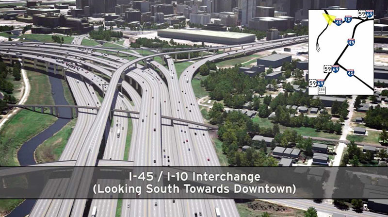
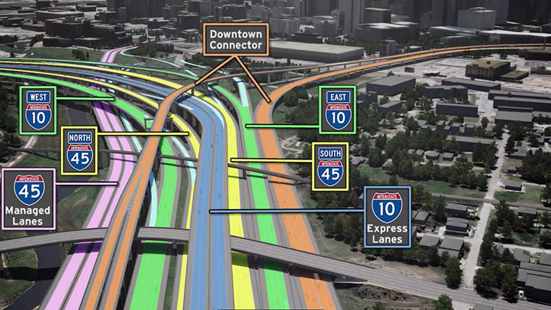
2. The New I-10-meets-I-45 Freeway Bundle. See, they’ll just reroute I-45 north of Downtown, where it’ll get all cozy with I-10, already in progress. Need help figuring out which patch of concrete is yours in the first image? Just refer to the handy color-coded guide above.
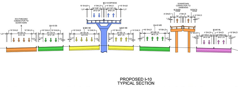
3. 28 Lanes of Freeway Bliss. And here it is, just your basic 28-lane highway, along the stretch of I-10 north of Downtown. Not counting any feeder-road additions, of course.
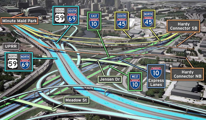
4. The New 10-45-59-69 Tangle. Whoah — that’s some World Class concrete spaghettini in there. Just follow the turn-by-turn instructions carefully and you’ll get where you want to go.
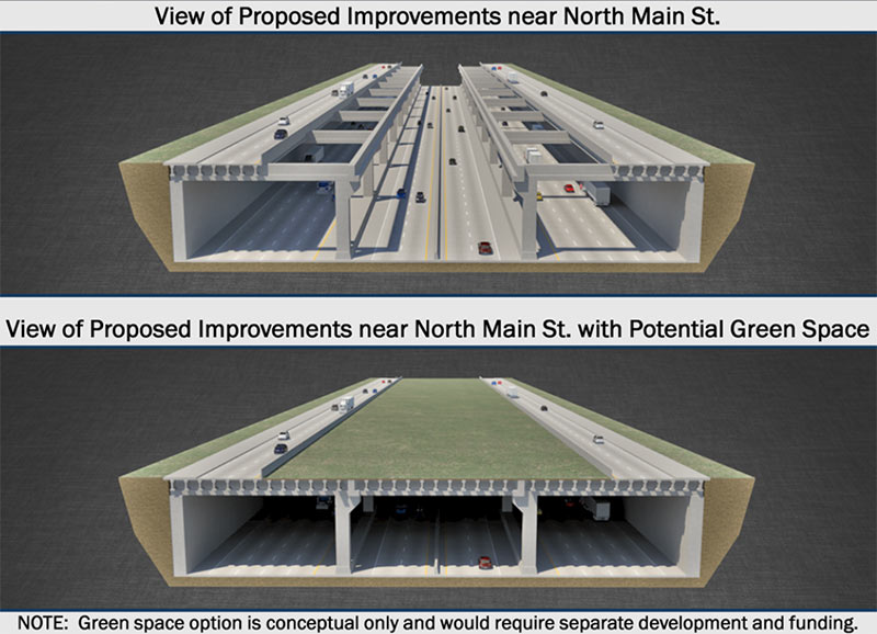
5. The Freeway Greenway You Can’t Easily Get To. Putting 12 lanes of the North Fwy. underground between Quitman and Cavalcade would free up a bunch of space for park-like greenery! Lining it with high-speed feeder roads on either side would help keep out undesirables.
- 4th Public Meeting Documents [North Houston Highway Improvement Project]
- TXDOT Releases Plans On Major Redesign Of I-45 In Downtown Houston [Houston Public Media]
- Massive I-45 project would remove Pierce Elevated, add lanes [Houston Chronicle]
Images: TxDOT



If they are still going to retain a “downtown connector” on downtown’s northwest side, they need to make it a surface-level boulevard similar to Allen Parkway, otherwise you still have a big concrete structure casting gloom over whatever you want to do there.
__
Oh, and before I forget – wow.
Welp…. On #4 i can almost see my home in that picture. I wonder if this will raise or lower my property value. /s
Getting rid of Pierce Elevated and opening up the west side of downtown would be the best thing to happen to Houston urbanism in a long, long time.
Why spend all that money to add managed lanes on 45 North only to squander it by sending them into the Milam/Travis ramps? If you’re going to put managed lanes on 45, you need to wrap them around Downtown to pick up the Med Center commuters.
How does Pierce Elevated thwart urbanism? That’s one of the most urban parts of Houston, what with all the homeless folks and squalor.
The downtown area schematic can be viewed here:
http://www.ih45northandmore.com/docs4/15_20150417_Seg3_PM4_Exhibit_01_Overall.pdf
I like this plan in general, although there are elements of this plan that seem bottleneck-y. And likewise, there appear to be a fair number of high-capacity ramps that are going into low-capacity parts of the street grid or that are removed altogether without a functional replacement. In addition to Purple City’s observation about the terminus of the I-45 managed lanes, the terminus of the 288 managed lanes seems likely to be an egregious problem that undermines its utility. And the Pierce Elevated in its current form gives vastly better access between neighborhoods in south and southeast Houston and Allen Parkway/Memorial Drive/North Montrose; there needs to be some accommodation that’s made in order to maintain mobility through there.
I’m going to echo Mike’s comment and go further by suggesting that the “downtown connector” spur needs to get a cut-and-cover treatment and that the street grid above it can then be made much more efficient, but also park-like and pedestrian-friendly. I would also suggest that the same kind of treatment should be developed for the Pierce Elevated ROW, which should be a spur. It doesn’t necessarily have to be a full freeway that handles through-traffic and it doesn’t necessarily have to be so big or so dark or so imposing, but it can and should provide a set of ramps that would diffuse the directionality of some of the downtown traffic patterns. The ROW exists and that’s a precious opportunity; it should be utilized.
The 288 managed lanes present a HUGE opportunity to serve the Texas Medical Center with improved P&R service out of west, northwest, north, northeast, and east Houston if they are extended to the 10/45/69 junction, to other managed lanes, and to the future Hardy Toll Road interconnects. As much land as TXDoT is already planning to take east of the Convention Center, they might as well take all of the land continuously that is between Hamilton Street and St. Emanuel Street and cantilever those two streets over a wider set of trenched mainlanes. That’d give them ample room with which to interconnect the various sets of managed lanes as they approach downtown and may provide additional opportunities to place ramps. This would also give them additional staging areas during construction. If funds are allocated to cover the trench, then that ultimately results in larger and more cohesive expanse of park land.
Okay, now onto my one cost-prohibitive and completely unreasonable request. I’d like to see all of the grade-separated lanes tunneled underneath Buffalo Bayou. With so much land being in play, the parks and urban development opportunities would be truly spectacular and both the parks and the cavities that contain roadways could be engineered to serve as a additional flood control infrastructure. Elsewhere, as much of the infrastructure as possible should be trenched in order to serve as additional stormwater detention capacity.
One last thing, a caveat on everything that I just said. I place a much higher value on free-flowing traffic over a very long time horizon than I place on the parks opportunities. If I’m right that there need to be more ramps and spurs and fewer bottlenecks and we also need to provide for increases in capacity utilization over time then it appears to me that double-decking is probably unavoidable. This project is probably going to be the last iteration of highway infrastructure serving Houston’s downtown area, so capacity needs to be the top priority. We shouldn’t forget that.
How will this increase vehicle speeds? I’d say they will be slower due to confused motorists trying to navigate this mess. I do like the high line idea for a portion of the old freeway, but you can tear down the northbound lanes to allow for development on Pierce street that border the new park
Nice! Houston’s version of The Big Dig. None of us would recognize Houston without some sort of highway construction or reconfiguration. The mighty car (and pickup) will always rule in Houston.
Ok, the true test of engineers not understanding Houston, they want ot build more below grade highways/streets. REALLY?? The images of floating cars and 18 wheelers on I-10 durning Allison and Ike were not enough? Tell you what, lest just put in a subway, what the hell.
First, all of the conceptual stuff is great to see since we like to dream big in Texas. But, in order to get to making it a reality, there will be an all-you-can-eat buffet of “fresh hot mess” from your appetizer of funding, main entree of demolition and construction, and dessert of drivers navigating the new roads.
.
The Pierce Elevated is choked with traffic but nothing can really be done. And, demolishing it would only transfer its current clog to the area on 10 between 45 North and 59 North. I avoid the Pierce if possible, check Transtar and Google Maps if I have to go through there, and budget about 15 more minutes for any last-minute clogs there. Or, thread through downtown and take the on ramp to bypass the elevated portion completely.
.
That being said, I’d wager that nothing will come out of all of this public discussion. Maybe an expensive study that will say: “We should study this more when we have money.”
If this doesn’t show that there is a problem with the lack of transportation options, I don’t know what will. Its not that they are adding 28 lanes, they are just taking the current 28 lanes and putting them in the same place. And adding highways doesn’t reduce traffic in the long run. It only encourages all new people moving to Houston to buy at least one car per person. At least the gas money stays local.
TxDOT must be smoking crack.
Getting rid of the Pierce Elevated is best. I could care less about the rest. Leave as is.
I anticipate the biggest transportation mess in the history of this city. Wouldn’t it be more cost efficient and less delays in just extending the rail to go down 45, I-10 and 59 or just start with 45?????? I am not a TX Dot expert but have you guys thought these plans carefully?????
Where’s the lights in the underground??? How hot will it be in there if there’s a park on top??? If it’s covered up and Allison happens, again, will it flood out and have a problem drying out like 59SW was??? Are you taking the nice view going into downtown just for a basic looking park, and does it have to be covered up all the way to downtown with a park and take all the view away from getting to and seeing downtown??? I LOVE my I-45 view.
@Major Market, I wouldn’t be too cynical about this not happening. The “Dallas Horseshoe” project is of similar size to this and construction on that is well underway. It takes awhile to percolate (we’re probably 5-10 years out from even seeing an RFQ for the PS&E packages), but getting massive highway improvements done in urban areas is a TxDOT core competency.
@TheNiche, agreed on almost all points. Most of the PM congestion exists because the original Kyser designs assumed half the traffic would peel off Downtown, no one anticipated how big the reverse- and cross-commute would get. This plan (and the related 288 schematic) doubles down on that imbalance.
I dont know if anyone realizes this but a ton of buildings would have to come down, including but not limited to:
-the newish UHD business building
-the entirety of Clayton homes
-most of old Chinatown
-Probably most buildings along Chartres St.
But hey its a small price to pay for getting 12 half blocks of parking lots for 12 new Skyhouses.
this needs to happen if for no other reason than 28 lanes of freeway traffic all next to each other. it will forever be a monument to the car, and it would be in gridlock at least 8 hours a day.
.
any blue blooded american should be excited.
All I have to say is that the complaints and concerns here will be meaningless unless you voice them through the proper channels. They’re listening, find their email address on the project’s website.
@ Nate & C: That freeways flood during major storms is a feature, not a bug! Flooded freeways mean fewer flooded homes and businesses.
@ Anna Lee: No, rail-based travel is both functionally impractical and inefficient in terms of cost because Houston’s employment patterns are so spread out. More importantly, the sources of funding are different.
I can’t wait for a single car fender bender, followed by 27 lanes of rubber-necking slowness for 3 hours.
Nice colors; in fact, it would be helpful and cheerful if the concrete could be tinted in those colors to assist confused motorists.
Lots to digest here, but having lived in Manhattan and experienced the fabulousity of the High Line I would like to hope that transforming the Pierce Elevated into a park resource is given serious consideration. Placing such a park at the confluence of Midtown/Downtown and Neartown could be exceptional.
Please realize that TXDOT is probably the most experienced roads in the nation and with TTIs innovate research im sure this is a great solution. And to add research shows that highway removal actually significantly reduces traffic congestion!
Surely it can’t be that hard to create pumping stations to empty below-grade roadways back into the bayou. doesn’t New Orleans have an extensive pumping system in place that already operates in this manner, while electricity is working at least?
.
As a reverse commuter this would definitely give me all the more reason to finally move out to the suburbs and avoid the high property taxes in town. 5 years of construction, gridlock and horrible cross-town freeway access would be a nightmare.
.
I still don’t understand whats so wrong with letting the freeways get clogged in the first place. There’s by no means a shortage of near-town land to be redeveloped and increase density five-fold.
If that bus station is still there when this goes down, that park will be full of criminals.
ooh boy can we get a little recession, please? Money for big hot mess plans…
What will actually make Houston into a city of the future is to freakin’ put away the cars and build transit options!
@ Adoile: Let’s not be too complacent about TXDoT, their capabilities, or their data. This is an organization (one of many) that had been politically monopolized by Rick Perry for a very long time. I’m not one to make public accusations of corruption or cronyism if I’m not parroting somebody else who has shouldered that risk…so I’m just going to stop talking right here.
No!!!
Money should go to trains!
Wow. This is a new TxDOT! Actually caring about how its roads effect neighborhoods. What a concept.
@ Purple City: I’m sorry if my tone seemed a bit cynical, which wasn’t my intention. I was aiming for pragmatism. For instance, there are so many logistics (funding, public hearings, acquiring property, demolition, and rebuilding) that I don’t see this moving quickly – and many ways that it could just come to a complete stop.
.
I’ve lived inside the Loop for several decades and not much freeway revamping inside the Loop really occurs. The Pierce Elevated’s rebuild in 1997 was the biggest thing in my memory and it still took a lot of effort. This larger scope proposal would take many years to gear up for and many years to complete. I’d be afraid that growth would overtake the original scope and we’d have a new set of freeways – that were immediately choked again.
.
In any case, we really could use a combination of factors to help traffic mobility: better bus and rail service, a decent recession to cool off migration, and better City management of local streets.
@Major Market,
.
Do you not also recall the major undertaking about 15 years ago to deepen the US 59 trench and rebuild the bridges for Hazard, Woodhead, Dunlavy, and Mandell, plus to continue the trench farther northward and sink the freeway under Graustark St and Montrose Blvd, returning it to its status of “Boulevard”? Whereas previously the freeway went over Graustark and Mt Vernon and Montrose, now it goes under Graustark and Montrose, and Mt Vernon no longer goes through. Also, Hazard used to live up to its name, because it was only 13′-something”, and 14’+ trucks used to regularly take chunks out of the bottom.
.
The Pierce Elevated reconstruction was memorable because I think it was the first project Williams Brothers ever finished early. It was also the first time TxDOT tried the carrot-and-stick approach: $10K bonus per day for every day early they completed the project, or a $10K penalty per day for every day they were late past the original deadline. Wonder of wonders, despite their history of lengthy project delays, on this one they finished weeks or months ahead of schedule.
Niche makes a lot of sense but I can’t help but wonder if he/she is retired, a city employee or just sipping beer at Woodrows with time to burn. PLEASE fill us in on your daily routine. I’m there.
i would bring up that bit about beating schedule on pierce elevated as a success. the road has been abysmal since day one and never should’ve been accepted in current condition.
I don’t commute into/out of/through downtown, so I have no dog in this fight.
But is this really $6 billion worth of value added?
After years and years of driving around this town, there are only a few small changes I would make to the system to make it better. First, TXDOT should look at bottlenecks at the major interchanges – anytime when the mainlane count goes down to 2 is the source of most of the chronic backups.
Take for instance the Pierce Elevated southbound or the Eastex southbound. 45 goes to 2 lanes and the Pierce is sluggish because of the lack of through traffic. Same with 59 south at 288. There are others – 610 North Loop at 45, I-10 at 45, etc.
I’m not sure a $6Billion revamp/reroute is necessary. Why not just eliminate these and other bottlenecks, especially if this amount does not increase capacity?
Look at http://www.pierceskypark.com
Re invent a freeway rather demolish it! Make comments to Tx Dot!
And just as the East End is revitalizing and becoming something special, this comes in to spoil the fun! I no longer go to midtown because there is nowhere to park and public transport sucks…..It really isn’t special. Just a bunch of apartments and a few pricey places to eat, drink, and shop.
@Dan I totally agree, the COH, Midtown TIRZ, new mayor, etc. need to figure out this problem. If money was no object I’d rework that whole area between I-45, Memorial Dr, Houston Ave, and the train tracks. Work in the new police station, municipal courts, COH permitting center, parking garages, and Greyhound station. The Amtrack is close by as well.
We need to make opposition, because i know about a cheaper way to reconstruct the pierce and downtown freeways, i created an entire plan of expansion of the downtown freeways and no one would listen amd txdot will not answer the emails that i have sent, so maybe there has to be more protests… specially since my plan doesn’t take as much property as txdot idea and i jave the idea of reconstructing and making a new pierce more modern. So it doesn’t get demolished, the best views of the Houston skyline are from the pierce between 10 and the 59 and it should be kept there. Their idea has to be stopped because those reasons i said. And for those in the north, northwest and west, it’ll take them longet to go to the south and southwest and we should keep the short distances like theu are with improvements and building the pierce over pierce street. Sorry it was too long but yeah…
How about ripping out the HOV lanes from the freeways and putting Metrorail out to the ‘burbs? You know, like everyone actually wants.
this is idiotic