
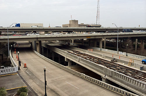
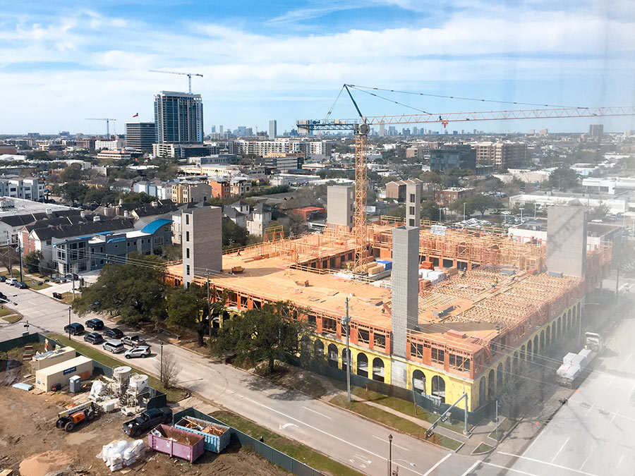
A reader who’s been watching construction of the new bridge that’s gone up over Buffalo Bayou and fitted neatly under I-45 at the far western end of the new under-construction Southeast and East End light-rail lines wonders what its purpose is. The bridge is beyond the planned Theater District stations, the last shared rail stops for the 2 lines. Is it a bridge to nowhere, or the starting point for some later western expansion along Washington Ave?
***
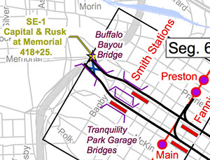 According to Metro, it’s neither. The bridge is how trains moving west along Capitol will turn around past the last station, so they can come back in the opposite direction, moving east along Rusk St. And vice versa. On the eastern end of the bridge, there’s a crossover (the ‘X’ on the map at left); beyond that there’s a “turnaround pocket” — just enough room for a train to pass the crossover and come back on the other track.
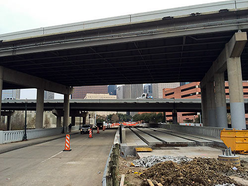
Photos: Jeff Peoples. Map: Metro
Duh!
Of course it’s a turnaround … for now. I’d also say it is a good sign for the Washington Ave/Heights area to get rail in the (probably distant) future.
I have always thought that those two lines are perfectly set up to be expanded in the future–one to Heights, another down Washington to connect with the in limbo Uptown line.
Well, a rail line down Washington makes so much sense. It would be great for dowtown tourists providing a quick ride to various hot spots along Washington. And to UH students would take rail all the way to Washington. And to people on Washington itself where moving up and down the bar/club scene would be made easy and safe. There’s also quite a bit of residential. The 2 lines that make so much sense are Washington and Richmond. Much headache in the building but great afterwards.
That was the question … Is it simply a turnaround or has anything been said that they have plans to go west someday. Would seem to be a very expensive turnaround, but likely there was no other way, and justifying it further would be the fact they know they’ll need it someday anyway.
they need to begin work on expansion almost immediately after this is done. Houston roads are absolutely unbearable. I want a solution to our traffic and connectivity problems, and that means invest ALOT of money in to making this system worth while…
i’ve been wondering why they put the east-bound tracks along the southern curb of rusk. because of this turnaround convergence, they have a place where the track crosses to the northern edge of rusk, which seems unnecessarily dangerous considering the trouble some drivers have coexisting with the train. why not just run the whole way down rusk along the northern curb of rusk to avoid this problem?
I wonder if the plan is to take the back way to the Galleria via Washington, etc., and then just let the public demand a Richmond line to complete the loop.
I always thought a line down Memorial Drive along Buffalo Bayou would be awesome. It seems like it would be pretty easy to adapt the stretch of Memorial from downtown to Shepard in to a rail friendly street–there are pedestrian crosswalks already, abundant lanes, and no stop-light intersections to contend with. They could take a lane or 2 from Memorial Drive, make a new right of way down the park, or even make an elevated line (which all of them should have been). The stops could tie in with cross streets or some the existing pedestrian bridges. This could be a real “showcase” line for the city being right next to what seems to becoming Houston’s prime inner city park location. The line could continue all the way into memorial park and maybe even somehow get to the Galleria.
And of course swamplot is the best forum for me to lobby my vision
There is a plan (sort of) to go west on Washington, eventually to the NW transit center at the north end of the Uptown line. The City and METRO studied that back in 2003. I know because I worked on it. The only reason it isn’t on maps is that METRO doesn’t want people interested in a line they have no money for, especially when they can’t even get University and Uptown built.
I don’t want to be a Debby Downer, but METRO isn’t going to expand the light rail for at least another generation.
METRO loses 25% of all the revenue it should be due and that lasts for another 20 years (b/c of last year’s referendum). The University line will take an act of Congress to get built as one was enacted to stop it. The Galleria is getting light rail’s ugly sister (BRT), and even that was met w/ stubborn and loud resistance.
For all of those clamoring for more rail, you need to really be concerned with the result of the ‘reimagining’ of METRO’s bus system due out this month. If METRO can produce a coherent and effective bus / mobility strategy, then we may see more rail in say 20-25 years. Fall short and I dare say that there is no real hope that METRO will be anything but a second rate bus system w/ some light rail lines that will primarily serve the poor and carless.
@DNAguy
This.
I don’t even know if Uptown BRT is a sure thing. Talking to TxDOT and COH folks recently, it seems a conflict with Memorial Park (along the feeder) has the potential to stop the whole thing.
Add to that that it would now be illegal to get federal funding for such a line if it traveled down Post Oak (where else could it really go)?
The silent lynchpin in Houston alternative travel is the passage of HB 200 last fall. It opens all power easements to bike trails. An interesting exercise is to imagine the effect of running rail and bike together. The holdup of passage was liability concerns. hopefully lessened by rail.
The unfortunate thing is that power lines cause interference with electric rail. What if natural gas technology being used for freight cars could be applied to transportation light rail? Look at an aerial map of Houston. The carbon footprint might be the green rail space of tomorrow.
So the average distance between stations on the Red Line between UHD and Wheeler is about 0.35mi (using that range because distance between stops increases Museum District and TMC). Would a light rail line going down Memorial need about the same distance between stops? I think a light rail line going down Memorial Dr. would be a great idea. There’s no stop lights from downtown until Detering St. (about 3 miles from the purple/green lines Smith Stations to the stoplight). The Buffalo Bayou Partnership would have to be on the same page through as some of the parkland would have to be used as right-of-way in some locations. I could see seven stations located along the Memorial line; Sabine St, Eleanor Tinsely/HPD Monument (south of Bayou), Studemont, Jackson Hill, Clements Spaceway, Westcott/Bayou Bend, and Memorial Park. Once the line got to Memorial Park could it use the existing right-of-way along the railroad that cuts through Memorial Park to then join the Uptown BRT?
Essentially, this is a very expensive turaround. No plans according to Metro’s site, http://www.gometrorail.org/go/doc/2491/1323787/System-Map, to follow a natural corridor along Allen Parkway/ Buffalo Bayou.
Take a look at the plans at the Metro site. Notice where where they’ve planned/ built and where they have not. Did the new lines (the Red Line extension, the Green Line, the Purple Line) really add major destinations other than UT and TSU? Did the under developed Eastside really need two rail lines? I feel the Purple Line is a route to nowhere. Similar feelings about the Red Line extension, unless it’s used to connect to the Heights area, Bush Intercontinental or both. It seems the Westside (Allen Parkway, Montrose, Westheimer, The Galleria, etc.) would of have been better served.
Any logic behind anything that Metro does?
P.S. please thank the fed’s for chipping in a significant portion of the rail expansion.
http://www.gometrorail.org/go/doc/2491/1323787/System-Map
@Blake
I’d encourage you to do a little googling bf you impune METRO for not connecting the Uptown and the westside w/ the existing light rail. They screw up enough on their own and don’t need any more ‘extra credit’.
Rep. Culberson has blocked any federal funding from going to those ares for the purpose of rail. Not so far off as to what former Rep. Tom Delay did in the early 2000’s.