
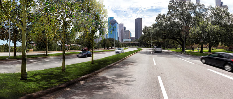
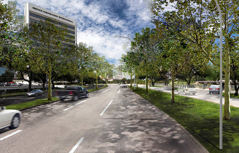
A couple of simulated fly-overs of a portion of a revamped Allen Pkwy., put together by consulting engineering firm Walter P Moore, show how the signature River Oaks-to-Downtown sorta-highway will look after a park-centered makeover is completed next summer. The projected $10 million redo partially answers the question popping up in many people’s minds after seeing all the new trails and structures and amenities and dogs going in along the bayou it lines: How are car-bound Houstonians supposed to get to the new Buffalo Bayou Park?
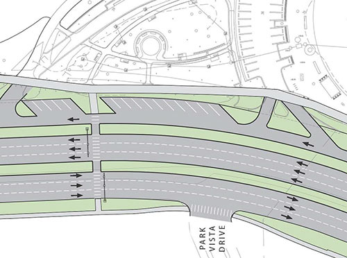
Part of the answer, of course, is by using 175 new angled parking spaces, most of them lining a new separate parking access lane lining the north side of Allen Pkwy. between Rochow St. and Eleanor Tinsley Park. As the video above (showing the journey eastbound from Montrose Blvd. to Park Vista Dr.) indicates, if you’re headed into Downtown, you’ll need to turn around and head in the opposite direction somewhere to park in one of them. Here’s a video view of the journey westward from Park Vista (across from Eleanor Tinsley Park) back to Montrose Blvd., along which the spots are angled for easy entry:
***
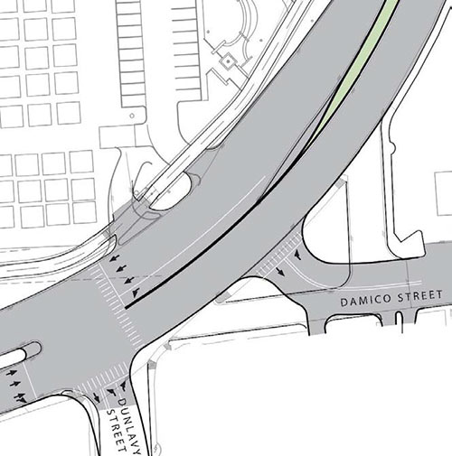
The new roadway will be slower; in addition to a speed limit that’ll be lowered from the current 40mph to a likely 35mph, new traffic signals at Dunlavy,
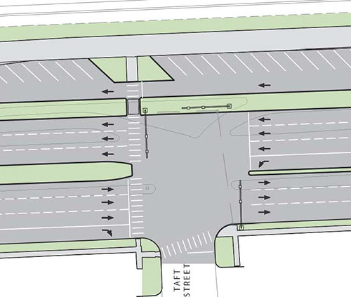
Taft St.,
and Gillette
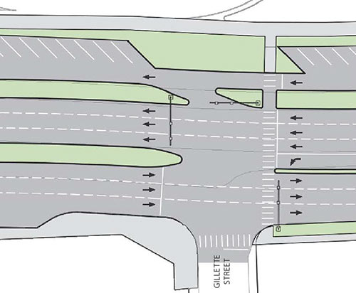
will allow the coming hordes of Montrose pedestrians to wander into the new park on their northern border; a pedestrians-only crossing will also go in across from Eleanor Tinsley Park, shown at the far eastern end of the sequence shown in the videos:
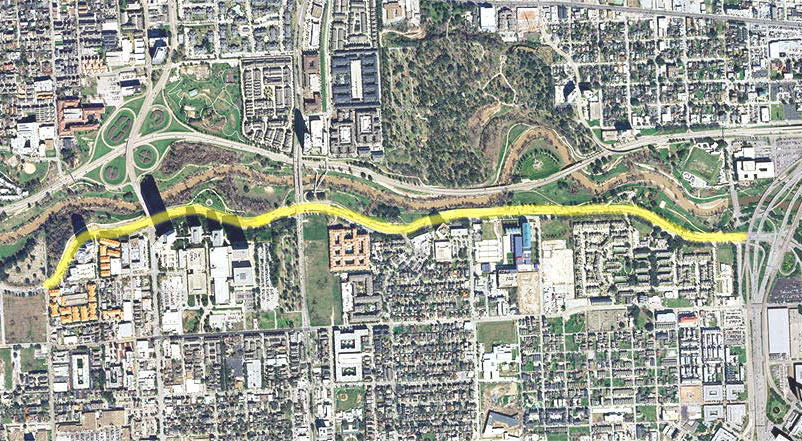
A traffic analysis suggests all the changes will add about a minute to travel times along the path of the reconstructed section, highlighted here:
Except for the removal of the existing 3-lane frontage road on the south side of Allen Pkwy. (and its replacement with a single one-way lane and all the angled parking on the north), the redo won’t take away any travel lanes — there will still be 3 on each side.
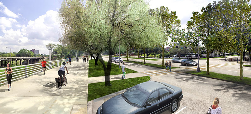
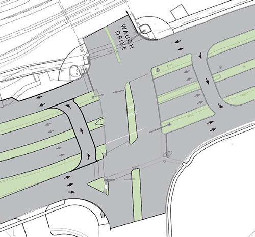
Here’s what the Waugh Dr. bridge crossing will look like:
The roadway is expected to remain open during construction, which will begin in July and finish the following May.
- Allen Parkway Improvements (PDF) [Downtown Redevelopment Authority]
- Allen Parkway Improvements Responses to Frequently Asked Questions (PDF) [Downtown Redevelopment Authority]
- Changes aim to put the ‘park’ back in Allen Parkway [Houston Chronicle]
- View Along Future Allen Parkway, Eastbound & Westbound [YouTube, via Walter P Moore]
Videos: Walter P Moore. Renderings: Downtown Redevelopment Authority

I would have preferred another pedestrian bridge over Allen Parkway, ideally around Waugh or Dunlavy, but I guess the added intersection is a decent compromise. Along with the slowing of traffic this should be a great improvement to the walkability of this area.
How long until the “this is interfering with my commute because I’m more important than everyone else” crowd starts complaining about the lowered speed limit and extra cars parking around the road. There’s this road on the opposite side of the bayou that is 15mph faster and oddly less used. No big deal. The whole park area is going to compare to some of the best parks in the country, let’s celebrate this accomplishment instead of coming up with lame reasons to hate it.
I predict that the very easternmost street-level pedestrian crossing will be ignored just as much as the existing pedestrian bridge over Allen Parkway to the east is now, with similar results:
http://www.chron.com/news/houston-texas/houston/article/Minivan-strikes-boys-trying-to-cross-Allen-Parkway-5329210.php
For the crosswalk to have even a chance of being used, it needs to be at the intersection with Park Vista, not half a block down. Do they think people are going to walk along the fenceline coming out of APV on Park Vista, then turn and continue walking along the fenceline a half block until they get to a crosswalk? Good luck with that!
It would be nice if there were plans for a bike/pedestrian bridge on Taft to avoid the lanes of traffic, but then I’m probably just being selfish.
It looks nice but I don’t understand how they will add that parking. I run that route quite a bit and can see it from my office. The concrete pedestrian paths they just laid are very close to the existing road. Those paths will be costly to rip up those fresh paths in order to add all that parking, not to mention losing a significant portion of the park itself.
well of course the street light at Dunlavy can’t come soon enough. best of all, we get to deal with Shepherd and Allen Parkway undergoing construction at the same time, can’t wait. not sure how well 35mph is going to sit with those used to doing 60mph on it though.
Seriously, it is going to take almost a year to build a walkway bridge.
rgrhourgr:
Remove the southern most frontage road and shift everything south, that’s where the space comes from.
Wow… this is going to be great
So the City has the money to reconstruct Allen Parkway but can’t come up with the money to fill in the potholes on Richmond Ave?
I hope they meter the parking to encourage carpooling to the park and keep people from hogging spaces all day.
If this only adds one minute, I’ll eat my socks. Not that I’m against it mind you, but that’s a bold prediction.
.
There should certainly be a pedestrian bridge put in, rather than crosswalks at grade.
So if the current speed limit is 40, and most people do 60, does that mean most people will now do 55?
@rgrhourgr,
.
I read in an earlier article that the way they will be adding that parking will be to take away the westbound lanes. Westbound moves to current eastbound, eastbound moves to current “feeder”, “feeder” goes away.
.
Ah, that was in the houstonchronicle.com article that is the third link below the story above.
As someone who has driven this road almost every weekday for ten years, and who has seen multiple cars flip themselves over because they are driving too fast, I will be glad with the lowered speed limit if they can actually make people drive it.
My wife and I were just talking about the need for something like this to protect pedestrians on the walkway from the idiots that think that’s a freeway. Nice to see they really are planning it. There’s already at least one spot on the walkway where somone ran upon the sidewalk and hit the barrier on the opposite side.
MontroseResident, I recall there is discussion of a new crosswalk at Taft. Maybe after that 10 acres develops into another apartment building, they’ll get critical mass to put one in. Nobody wants to use the one across from the projects because they’re afraid they’ll get mugged.
rgrhourgr, if you look at the Gillette drawing, you see they’re eliminating that access road on the south side. That’s where the space is coming from for the parking. Basically, they’re moving that space to the north side, and turning it from a 2-lane road into a one-lane with parking.
this is a BAD idea. The parking needs to be on the other side of Allen Parkway.
Reason #1. AP is booked nearly every Saturday and Sunday morning with a 5k or 10k or something. This will make the parking inaccessible during the most needed time.
Reason #2. Don’t put the CARS next to our rare picturesque spots. We finally have a good looking area and then have to pave it. Very short sighted and will uglify. Keep that side good looking and put the cars across the street.
I live right off Dunlavy and love what they are doing with the park. However, I don’t like the idea of a light at Dunlavy. The intersection gets backed up a little but because you can only turn east off of Dunlavy but it isn’t to bad. I think this would be great spot for an elevated pedestrian bridge directly into “Lost Lake”.
First the speed limit on Allen parkway has been 35 or 40 forever so anyone going 60 mph has a good chance of getting a ticket. Memorial drive has always been 50mph.
Second did the firm who made this animation take global warming into consideration and show the new coastline where the Med center Midtown and the third ward used to be.
Third I believe the sidewalks they just paved will be fine since I think they plan on rerouting the roadway a little farther south of the sidewalks, and take in the extra lane on the south side of Allen Parkway.
I would like to see the kinds of bridges they used on Ladybird Lake in downtown Austin with the spiral ramps.
No no no. This looks bad for traffic, bad for the park and just overall bad. We are going to tear up one of the few streets that actually functions. We waited so long for a great park only now to be disrupted by the road construction. I guarantee you the road folks wont leave the park how they found it.
I agree with GoogleMaster. That crosswalk to the left of Park Vista Drive is not inviting. Either put up a bridge, or completely signalize an intersection for that crossing. From the video, it doesn’t look like those crosswalks will have full signalization to begin with. I certainly hope people will slow down on this stretch of roadway.
When I first heard about this project, it was from a planner type who was excited about “taking back the street for people instead of cars” and other such sentiments. Naturally I was… concerned about the traffic impacts. Thankfully, the COH still forces us all to design to 2035 ADT, so despite the best intentions of the AICP set we end up with streets that are both functional as well as liveable.
Everything about this project is a no-brainer. Getting rid of the high-type “T” at Taft in favor of an intersection that pedestrians can cross legally just makes sense. Reassigning the existing travelways to eliminate that pointless southside feeder road just makes sense. Preserving trees just makes sense. Adding parking for park users just makes sense. And while Ms. Parker’s administration has been a bit too aggressive with speed limit reductions for my taste, in this particular instance 35mph makes sense – given the geometry and the additional signals.
Eliminating the left-hand merge onto 45 South makes a *lot* of sense. Pulling back the gore so that eastbound Allen Parkway traffic first chooses IH-45, then picks north or south… makes sense. And that roundabout at the south end of the Sabine Street bridge… someone’s going to say it doesn’t, but they’re wrong, that makes sense too. If you’re looking for a spot to unload your skateboards, you don’t want to get sent all the way out to Montrose on the new can’t-escape-it northside feeder road.
Kudos to the Walter P Moore and SWA team for an excellent design that will be an asset to our city in the years ahead.
I do love me some Allen Parkway Rally Racing, but I have to agree that this is for the best. The road’s present configuration encourages speeds that are completely unsafe given the heavy pedestrian traffic alongside it, and the numerous intersections and crossing points, not to mention the poor condition of the road surface.
@ShadyHeightster Yeah, what the heck is up with Richmond, is PWE taking the piss? How much worse can it get?
Re: potholes on Richmond – 311 request on line – it works. They say they try to get to requests within a week and they have for the ones I’ve pointed out. If it’s a danger to cars / bikes / pedestrians be sure to tell them that, too. Squeaky wheel gets the grease, so to speak–the city doesn’t send crews around looking for potholes to fix.
Awesome. I don’t think there should be a light at Dunlavy. I think they should just put up a barrier to the west bound lane.
In a few years we will all look back and realize how awful google earth is, right? I hope.
@Rodrigo, @ShadyHeightster:
.
My theory is that PWE is still in the mode of deferring fixing Richmond until the rail is under construction, so that the street only needs to be torn up once.
.
Of course, since that’s not happening anytime soon, it means that the street just gets worse.
.
But hey, at least they’re finally rebuilding Shepherd!
I like Neighbor in Montrose thoughts, pretty interesting.
Wont happen, but like it.
Need more complete plan for Montrose and Waugh. There are lots of peds and bikes going to Allen and those are primary crossing, especially with whole foods being on Waugh.
What would be really nice is if they would also pave concrete on the curvy asphalt death traps. It’s the most dangerous street in Houston.
@Neighbor in Montrose –
There’s currently no separation between the curb and the idiots driving down AP. That’s exactly where the parking needs to be, to protect the pedestrians. What kind of better pictures do you expect from your scenario? It will be vehicles barreling down AP rather than parked, that’s it.
As for parking being inaccessible during all the AP closures, so what? AP has NO parking to speak of now, so it’s hardly going to make things worse during closures. In fact, it will give all the event organizers and volunteers a place to park near the event, rather than filling side streets.
Incorporating hundreds of parked cars into the view will ruin it. Also, is the city going to send out daily crews to clean up the litter dumped by the people getting out of their cars?
When can we expect pedestrian crossing signals at the Shepherd / Kirby intersection? Also, is there any discussion of a tunnel that would allow pedestrians coming from Shepherd / Kirby to reach the park without having to maneuver that intersection (similar to what’s over on the Memorial side)? Finally, the sidewalk from the West Gray / Shepherd area down to the park is generally a mess. I know some of this is related to all the Shepherd road construction, but I hope there is a plan to possibly widen sidewalks, trim back bushes and trees, etc., to create greater accessibility at this entry point and would love to hear about that from anyone who is informed.
It needs a John O’Quinn monument.
Wonder how this will effect the art car parade.
(No one cares about your precious view, Dan)
“Here’s what the Waugh Dr. bridge crossing will look like:”
How is that any different from what is there now??
Are there plans to redo those deadly ramps connecting Allen parkway to I-45 as well??
Are they going to fix the death ramps to 45? This is badly needed and looks good. Still you would think this was the only road and the only bayou in Houston.