COMMENT OF THE DAY: A HISTORICAL METHOD OF EXPANDING HOUSTON’S FLOODPLAINS  “Another recent policy development is that subsidence is now taken very seriously (with massive infrastructure being built to put utility districts onto surface water from Lake Houston and the Trinity River). But it was a very, very big problem up until around 1990. So you had all this sprawling development inside of Beltway 8, and off of 1960, and out near West Oaks, and there wasn’t adequate on-site or off-site stormwater retention infrastructure that had been built — and that same development thereafter was sinking at a steady rate, so that any flood control infrastructure was becoming increasingly obsolescent for reasons other than simply rainfall rates and runoff.” [The Niche, commenting on Comment of the Day: Who Foots the Bill for Houston Floods] Illustration: Lulu
Sign up for the Newsletter
Quicklink

COMMENT OF THE DAY: WHO FOOTS THE BILL FOR HOUSTON FLOODS  “Since much of the development inside the Loop is done over existing impermeable surfaces, it would seem to me that the majority of the additional demand on our bayous is coming from the large greenfield production builders further upstream. My intuition is that the amount of building going on out there most likely dwarfs what’s occurring inside the Loop (can anyone find numbers on this?). And what’s really fueling all that development is the billions of federal, state, and local tax dollars going [toward] expanding and enlarging highway construction all over the place. By reducing the time/cost of commute, they serve as enormous incentives enabling building and selling more cheap houses further away from the employment centers closer to the city. In a nutshell, that is the sprawl Houston is famous for and I think the main source of our flooding woes. There’s no easy answer since we all want cheaper houses — but someone pays for that, somewhere.” [Build Up, commenting on Why Houston Keeps Flooding; Meet Photo Blog Purple Time Space Swamp] Illustration: Lulu

COMMENT OF THE DAY: HONORING THE SECRET FUNGAL AUTHOR OF THE HOUSTON SAGA  “The toxic mold madness explains the entire history of our region. Think about it: the cannibal Karankawas on the Island of Doom, the ignominious and mysterious defeat of Antonio Lopez de Santa Anna, the mass hallucination that Buffalo Bayou was a navigable waterway on which a major port could be constructed, the race for space, the Candy Man, Mattress Mack and the subsequent mattress obsession, Robert Durst, the tree holocaust, and so on. We should name toxic mold as the official mold of the City of Houston.” [Memebag, commenting on What Floated and What Didn’t by the Halstead Apartments at N. Braeswood and 610] Illustration: Lulu

A NEW FLAG FOR FLOOD CITY  Writes Cort McMurray of Monday’s flooding: “This week’s ‘historic’ rainfall (shake it off, TV weather people: if it happens once, it’s historic. If it happens every single year, it’s just rain) gave us the perfect symbol. You’ve seen it — it’s all over the Internet. Somewhere in our Xanadu on the Bayou, an intrepid Houstonian was spotted, knee-deep in rainwater and soaked to the skin, a yellow slicker hanging haphazardly on his shoulders, surrounded by flooded cars and floating debris, toting a waterlogged armadillo to safety. That’s it. That’s our new flag. Because wherever you live in this far-flung metropolis, you know what it feels like to be soaked to the skin and up to your knees in rainwater, carrying a stranded armadillo to safety. We’ve all been there, haven’t we? It’s the closest thing we have to a universally Houston experience.” [Houston Chronicle] Photo of armadillo rescued from Greens Bayou: Doug Miller

COMMENT OF THE DAY: ALL FLOODING BUCKS PASS THE SAME DIRECTION  “Every solid thing built in a floodplain displaces water to the surrounding areas and to downstream. Houston just keeps screwing its southeast neighbors.” [movocelot, commenting on Elan Heights Shows Off Its 4 Floors of Apartment Flooding Insurance]

CITY WATCHING ADDICKS AND BARKER DO THEIR OWN DAM THING  The US Geologic Survey’s tracking of water collecting at the Addicks reservoir this week shows water levels jumping about 28 feet since yesterday morning, in the preliminary data graphed above. Both Addicks and Barker reservoirs, which function in large part as parkland when not busy storing potentially billion of gallons of floodwater, feed out into Buffalo Bayou near Hwy. 6 at Westheimer Dr. through dam outlets listed as extremely high risk structures by the USACE. The city’s Twitter account noted this morning that the Addicks dam was under municipal scrutiny; the Office of Emergency Management tweeted this afternoon that the stretch of Hwy. 6 and N. Eldrige Pkwy. running through the Addicks reservoir may be closed for a few days while the area drains. [USGS; previously on Swamplot] Graph of Addicks Reservoir water surface elevation since April 11: USGS

POPULARIZING TIRZWATCHING AS A HOUSTON PASTIME 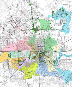 This week the Houston Chronicle editorial board called for TIRZ authorities to keep publicly accessible and up-to-date records, as well as to start recording videos of their meetings, as occurs with city council proceedings. The board says that the 27 TIRZs in Houston collected more than $100 million in 2015 — “about what the city spends on parks and libraries combined,” allowing some individual TIRZ management authorities “to take on projects with a region-wide impact.” Some Houstonians have already been keeping an eye trained on the TIRZ’s movements, cameras or no — last month residents of the Cosmopolitan condos (via Wayne Dolcefino) filed a criminal complaint alleging that members of the Uptown TIRZ had failed to keep records of meetings related to the purchase of land for the Post Oak bus lane project. Meanwhile, a group of residents on the flood-prone Memorial City TIRZ is preparing a lawsuit related to this week’s city council approval of new TIRZ board members. [Houston Chronicle; previously on Swamplot] Map of Houston Tax Increment Reinvestment Zoness: City of Houston

COMMENT OF THE DAY: BUILD UNTO OTHERS AS YOU WOULD HAVE OTHERS BUILD UNTO YOU  “For this city-wide Houston experiment of no zoning to work, it takes good judgment, responsible developers, people living by the golden rule, doing what’s right, loving thy neighbor, walking a mile in another man’s shoes (or zipcode!), however you get there. I mean that. And I love Houston because — shockingly — this mostly works. When it fails, laws do exist to establish a minimum standard we all live by; those minimum standards [get] called on because someone tried to circumvent the law and selfishly do whatever the hell they wanted anyway.” [G Rod, commenting on The Shakeup Around White Oak Music Hall’s Outdoor Stage] Illustration: Lulu

THE SHAKEUP AROUND WHITE OAK MUSIC HALL’S OUTDOOR STAGE  The permanent outdoor concert stage suggested by renderings of N. Main St.’s newest music venue, Erin Mulvaney writes this week, wasn’t included in the building permits approved for the venue; for now, it appears that the blue-roofed temporary stage used for the music hall’s first concert this past weekend will be covering the outdoor gig indefinitely. Meanwhile, Houston police documented at least 17 noise complaint calls from the immediate area on Saturday night, and 1 during the leadup week; multiple residents near the spot tell Mulvaney that their homes were vibrating to the music of French electronica group M83. Area resident Kerry Whitehead remarks to Swamplot on her observations from her home nearby: “I recently read a quote in a 1983 Texas Monthly article about our stretch of Main Street . . .  seeing I-45 in proximity to Hollywood Cemetery (an ‘old, lush place’ then, as it is now), the author remarked that he imagined ‘the bones of the nineteenth-century dead rattling in resonance with the vibrations from the freeway.’ Well, if those bones resting in peace hadn’t been rattled yet, they were rattled on Saturday night — as was I.” [Houston Chronicle; previously on Swamplot] Rendering of White Oak Music Hall complex: White Oak Music Hall

COMMENT OF THE DAY: TAKE CARE OF THE OTHER BURIALS BEFORE PUTTING I-45 IN THE GROUND  “I don’t understand why people want to bury the Pierce Elevated. That seems like something to put onto the table after all the murders are solved and money starts to rain down from the sky. Can someone explain this to me? How could it possibly be practical to tear down this road?” [Commenter7, commenting on Defending the Pierce Elevated; The First Toucan Traffic Signal in Texas] Illustration: Lulu

COMMENT OF THE DAY: BOTH OPTIONS FOR DEALING WITH RUN-OF-THE-MILL HOUSTON TOXICITY  “My wife, until last May, worked at a school very close to this (but [which] was not mentioned). The air pollution on normal days is so bad that my wife’s doctor suggested that if we wanted to have children that she should think about changing jobs.  . . .  Attention is only drawn to the problem when major events happen — but perhaps long term effects of living and working in the area are greater ([and] simply tolerated as business as usual). I have said it before, but it is worth mentioning: I called the TCEQ and many agencies during my wife’s time working over there about the pollution . . .  they informed me that the area has regularly violated EPA standards and my only option was to ‘vote for people who care about government regulation’ of said pollution. Sounds like a tough project!” [Anon, commenting on This Morning’s LyondellBasell Refinery Fire Put Out 19 Hours after Yesterday’s ExxonMobil Refinery Fire] Illustration: Lulu

CRIMINAL COMPLAINT FILED ON BEHALF OF COSMO RESIDENTS OVER POST OAK BUS LANE LAND PURCHASES 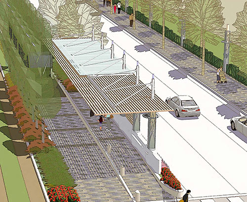 Former ABC13 investigative reporter Wayne Dolcefino, representing residents of the Cosmopolitan condo tower on Post Oak Blvd., filed a criminal complaint with the Harris County district attorney last week over the way the Uptown Development Authority has gone about acquiring land for the dedicated bus lanes planned along Post Oak. The complaint asserts that officials of that group and the Uptown TIRZ may have violated Texas conflict of interest law, as well as the Open Meetings Act. Nancy Sarnoff writes that Dolcefino’s complaint also calls out Uptown’s purchase-agreement-less purchase of a piece of land at San Felipe and Post Oak, from an associate of Dinerstein (which is preemptively suing the Cosmo residents over a tower planned at the same intersection). Uptown District president John Breeding tells  Sarnoff that it’s not unusual for public entities to buy land without a formal sales agreement, and that details of the transactions will be available after they’re complete. The Uptown group either has bought or is working on buying about 80 percent of the land needed for the project; the city council voted in December that eminent domain could be used to acquire the rest, if necessary. [Houston Chronicle; previously on Swamplot] Rendering of proposed dedicated bus lane on Post Oak Blvd.: Uptown District

COMMENT OF THE DAY: THE JOBS WILL GO WHEREVER THE WIND BLOWS THEM  “I think it has less to do with the location of high-paying jobs, and more [to do with] proximity to the Ship Channel and its pollution. If you look at wind pattern maps, all the historically least-desirable areas are where prevailing winds off the coast end up tending to blow pollution originating from the Ship Channel. The high-income jobs are located west of downtown because that’s where the high-income people wanted to live, not the other way around. This isn’t specific to Houston, either – the west side of most North American cities tends to be the more desirable side, owing to prevailing winds and the location of dirty industrial areas. Chicago is an excellent example — the south side being less desirable owing to its location downwind (south and east) of the massive stockyards that existed there a century ago.” [TMR, commenting on Comment of the Day: Breaking the Cyclical Expansion of the Donut of Despair] Illustration: Lulu

COMMENT OF THE DAY: BREAKING THE CYCLICAL EXPANSION OF THE DONUT OF DESPAIR  “Nobody is suggesting that we go back to the old, post-war, car-centric way of developing. Even single family, suburban communities are now being built with something resembling walkability in mind. They have made the houses much more dense, and they have made efforts to link retail to the neighborhoods. But what we risk doing is creating donut cities: with a core of walkability, older suburbs that are not walkable, and a ring of new, sort-of-walkable suburbs. Worse than that, if we continue to starve those older suburbs of investment (on the idea that we don’t want to ‘throw good money after bad’ or whatever), we will create wealthy cores, poor old suburbs, and middle-class new suburbs. Still worse, if we allow this to happen, we will cause more sprawl, because middle class people won’t see the old suburbs as an option, so they’ll keep driving further and further out. At some point, like it or not, we will need to reinvest in those older suburbs – and it’s for the sake of building more sustainable, equitable cities.” [ZAW, commenting on Bellaire’s Hong Kong Chef Serves Last Customers; Sunbelt Cities Are Just Misunderstood; previously on Swamplot] Illustration: Lulu

COMMENT OF THE DAY: STILL LONGING FOR THE COMMERCIAL COMPANIONSHIP OF DAYS GONE BY 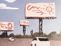 “I miss the billboards of my youth. I grew up in a world where the freeways were surrounded by them, and never thought much about it. Now that they are almost all gone, I realize they gave the city character. I don’t understand the hate for them.” [Memebag, commenting on Comment of the Day: What Keeps Houston Billboards Standing Tall] Illustration: Lulu
