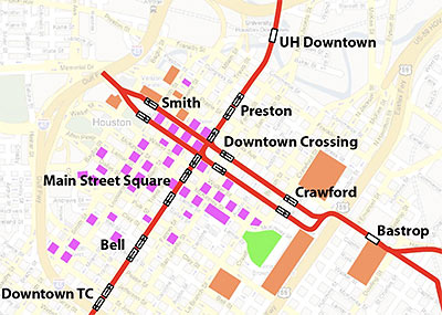
Christof Spieler returns from a Metro meeting with some new detail on the proposed Downtown routes for the Southeast and East End light-rail lines.
Spieler politely calls the latest plan a compromise. (“I doubt anyone is really happy with it,” he writes.) It has Metro siting the two lines — which will run on the same tracks for most of the crosstown trek — along the south side of Capitol (heading west) and the south side of Rusk (heading east). But unlike the trains that run down Main St. today, the new vehicles won’t have any right-of-way advantages over cars:
Like buses do now, the trains will share the curb lanes with cars, both turns and through traffic. . . . And the signals will be operated as they are on Capitol and Rusk today: trains will find the lights are sometimes green and sometimes red, and they will stop or go accordingly. There is no doubt that this will slow trains down and throw off schedules: for example, a line of stopped cars in the left lane on one block would force the train to hold in the previous block until the cars moved. It might also be a safety issue, but that’s not as clear.
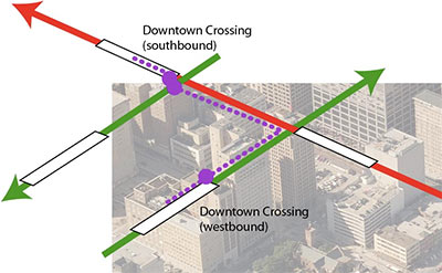
The new lines will intersect with the Main St. line at a new Downtown Crossing station, which will likely require passengers to do plenty of street-crossing themselves:
there are 4 platforms — north- and southbound Main Street and east- and westbound East End/ Southeast — that can share one station name, making the system easy to understand. But the east-west platforms are a block away from Main Street, so some transfers will still involve a three block walk, with 3 pedestrian lights, from the center of one platform to the center of another.
After the jump: The end of the line!
***
Here’s Spieler’s Live Maps-style Downtown Crossing diagram:
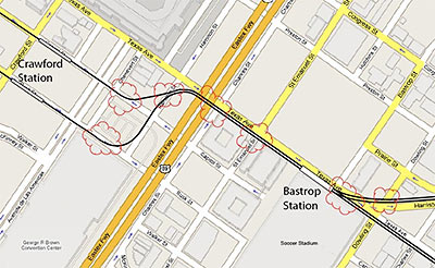
Spieler also shows this closeup of the “squiggle” in the track near Minute Maid Park, the George R. Brown, and the proposed soccer stadium:
. . . but he clearly favors the opportunities out west:
One good thing about this alignment is that it works well for westward expansion. The tracks will join over Buffalo Bayou, at I-45 between the Hobby Center and Bayou Place. For now, this is where trains will change direction. But these tracks will point directly towards the city courts and Houston Avenue, where the future Inner Katy Line (also authorized by voters in 2003) could head towards Washington Avenue and/or the Heights on its way to the Northwest Transit Center.
- Downtown crossing [Intermodality]
- Previously in Swamplot: The Light Rail Map Update Metro Didn’t Announce, Live Search Maps Update: A Road Runs Through It
Images: Christof Spieler


This is dumb. Since its been proven over and over again that vehicles and trains on the same street don’t get along, just make one street exclusively rail going in both directions. If Metro can’t afford to go up (monorail) or below (subway) with the rail lines, they should take a quick trip up to Calgary to see how street level rail works well thru a downtown core. They could learn lots.
Don’t assume this is what METRO wanted. METRO wanted two tracks in the middle of Capitol, much like Main Street. But METRO doesn’t get to do whatever they want — the city has to sign off and, in this case, the Downtown District more or less has to sign off.
But I also agree that METRO has lots to learn.
Take a que from Chicago’s L train. It runs above the city roads and very effectively I might add. Who ever thought to put this stupid train that we have now, is well..I don;t want to be rude….It’s similar to Downtown Dallas, and look at Dallas, it’s DEAD downtown…..help bring life back to downtown where it belongs and build the train differently……above the commuter traffic!!!!!!!!!!