09/20/17 12:00pm

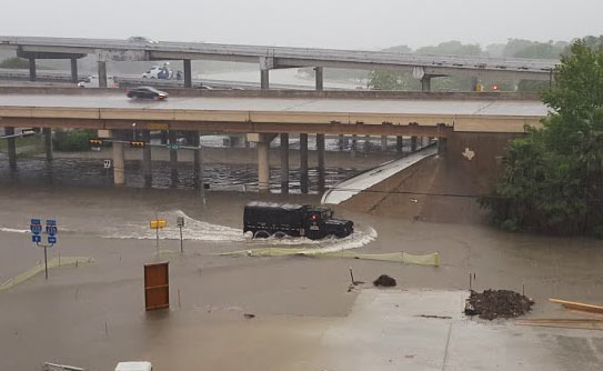
It’s coming a little late for many homes in Meyerland, but excavation crews are once again at work widening the segment of Brays Bayou just downstream of that flooded neighborhood. Work on the segment between Buffalo Speedway and S. Rice Ave. began this past summer. The widening is a part of the decade-plus-old Project Brays, begun before but accelerated as a result of flooding during Tropical Storm Allison in 2001.

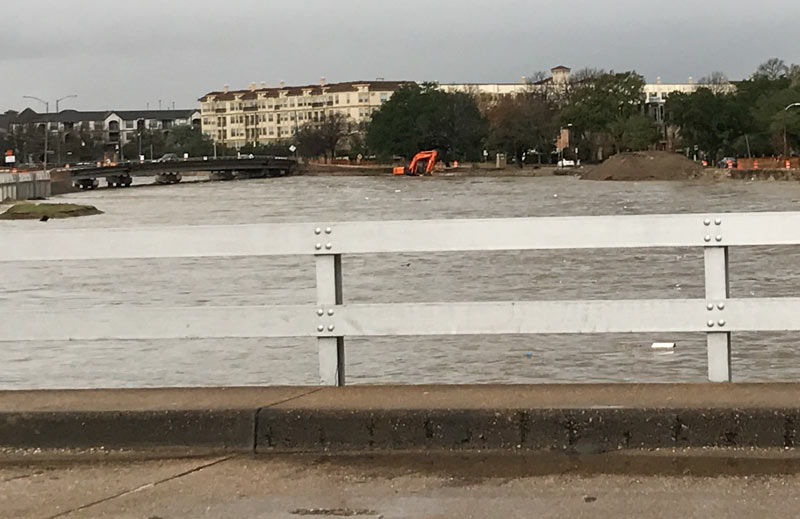
Water levels on the bayou have returned to a manageable level; this photo, sent in by a Swamplot reader, shows an excavator at work on its south bank just west of the inlet between Timberside Dr. and Bevlyn Dr.

Photo: Swamplot inbox

Braeswood Place
01/24/17 10:15am

CITY HOPES TO CHOP A DECADE OR 2 OFF THE BRAYS BAYOU FLOOD CONTROL TIMELINE Flooding around The Halstead 4620 N Braeswood Blvd., Meyerland, Houston, 77096 At the current rate of federal funding trickling in for the completion of the Project Brays flood control project, the work could take another 20 years or so to complete, Mike Morris writes this week — noting that the Harris County Flood Control District originally expected about $50 million in federal reimbursement every year, but has been getting an average of $11 million annually in recent years. The city is now planning to speed the project up by asking to borrow $46 million from state-level funds to give to the county, potentially helping it meet or beat a 2021 completion deadline. And “yes,” says city flood czar Steve Costello, “the city is going to be taking [a] risk because we’re going to be waiting for the money, but we’re confident that this is the start of a long-term relationship and we think it’s going to work very well.” (If it does work well, the city may do the same thing for work on White Oak and Hunting bayous.) [Houston Chronicle; previously on Swamplot] Photo of Tax Day flooding at Brays Bayou and 610: Chris Klesch

01/19/17 4:15pm

Flooded Project Brays Construction Site, Brays Bayou at Main St.

If you have information regarding the whereabouts of the cheery orange digging machine spotted yesterday morning dipping its tracks into a brimming Brays Bayou, a concerned reader would like to hear it — the shot above is his last sighting of the machine, taken from the Main St. bridge. “When I looked today, it was gone. Any idea what happened to it?” 24 hours, of course, is plenty of time for someone to have taken the excavator somewhere warm to dry off, so no reason to assume anything particularly unfortunate transpired; the photo was taken around 8:30, a little over an hour after the water had begun to recede from its early morning crest, according to the Harris County Flood Control gauge readings at the Main St. bridge:

CONTINUE READING THIS STORY

No Reward
09/11/13 11:10am

Just about a mile as the trash floats along Brays Bayou from that sylvan site in Idylwood where the Houston Parks Board is considering building a parking lot, more work of the flood-mitigating Project Brays is underway. Here, near the intersection of Wheeler and Old Spanish Trail, the Harris County Flood Control District is widening the channel to help the bayou along, an act that will necessitate spending about $4.2 million to build a new 2-lane bridge.

According to the HCFCD, the existing bridge on Wheeler — shown in the photo here — isn’t nearly big enough and will need to be demolished. The new bridge, to be built during the next year or so, will extend Lidstone St. up and over the bayou to O.S.T., connecting the Gulfgate and Fonde Park neighborhoods just southeast of the Orange Show. Once the bridge is complete, more hike and bike trails will be installed.

You can see a project map and more photos after the jump:

CONTINUE READING THIS STORY

01/08/09 9:28am

The high point of River Oaks Examiner reporter Rusty Graham’s tour of Project Brays, where flood control is measured in Astrodomes: sheep — on an actual hill — overlooking Brays Bayou flood-reduction projects at the Eldridge Road basin.

The group arrives at the Eldridge detention basin, at the end of Westpark. Harris County Precinct 3 is developing Archbishop Joseph A. Fiorenza Park at the facility, which is about 45 percent complete.

Eldridge is the largest of the four basins, with a total area of 337 acres. Eldridge will hold 1.5 billion gallons of stormwater when complete, or nearly three Astrodomes.

One of the highlights of the trip is seeing the sheep on a large hill on the west side of the Eldridge basin. The 60-foot hill is built from dirt excavated on site.

The sheep lived in the area before the site was purchased, says Heather Saucier, spokeswoman for the flood district. They’re tended by an area resident, although on this day they seem to be doing well enough on their own.

The hill’s summit offers a commanding view of the area, and is especially impressive looking back towards the Uptown area to the east.

Photo: River Oaks Examiner