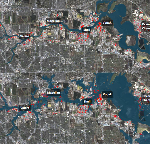
WAIT, DID THE 2008 RECESSION UP THE CHANCES OF A FUTURE HOUSTON CHEMICAL CATASTROPHE?  Roy Scranton imagines “a wave of water sweeping toxic waste into playgrounds, shops and houses” in Magnolia Park in his op-ed this morning, written after touring the Ship Channel and speaking with the local A&M and Rice research teams pushing for variations on a series of region-scale coastal barriers to hunker down behind whenever the next gigantic hurricane hits the Houston region, in hopes of avoiding deadly flooding and catastrophic chemical spills. But the researchers tell Scranton that pushing for federal and state funding for a response is a slow endeavor; Jim Blackburn (a main player on the Rice team) tells Scranton that he’s “heard more than one person say our plan is to wait until the next hurricane comes, then depend on guilt money from Washington to fix the problem.” Scranton writes that the best chance for that guilt money so far might have been in 2008, when Hurricane Ike landed just 30 miles northeast of the zone that modelers say could have caused thousands of deaths and irreparable ecological devastation to the area, on September 13th — 2 days before the Lehman Brothers filed for bankruptcy, pulling global attention and national funds to other issues as markets began to crash. [NY Times; previously on Swamplot] Model maps of potential storm surge flooding along the ship channel, with chemical storage marked in red: Texas Tribune
Tag: Chemical Spills
DEPT. OF PUBLIC SAFETY TO UT: PLEASE DITCH THE PHOTOS OF FLOOD-RELATED CHEMICAL SPILLS WE DIDN’T NOTICE Meanwhile, in Austin: Texas Department of Public Safety officials have recently asked the University of Texas to remove an online collection of aerial photos taken by the Texas Civil Air Patrol during major flooding events, Marty Schladen writes in this weekend’s El Paso Times. The request comes after the Times reported earlier this spring on what appeared to be photos in the database showing a number of chemical spills not captured in any other state monitoring records, including spills along the Trinity river north of Galveston Bay; other photo sets previously on the site reportedly included shots of Houston sewage treatment plants being flooded on Tax Day, as well as possible unreported spills along the Colorado, Sabine, Red, and Pecos rivers since 2014. DPS Spokesman Tom Vinger tells the Times that pulling the photos is a matter of protecting privacy — “for example, there could be pictures of deceased individuals prior to family members being appropriately notified first,” says Vinger. Non-emergency-responders can still ask for the photos via Public Information Act request. [El Paso Times]

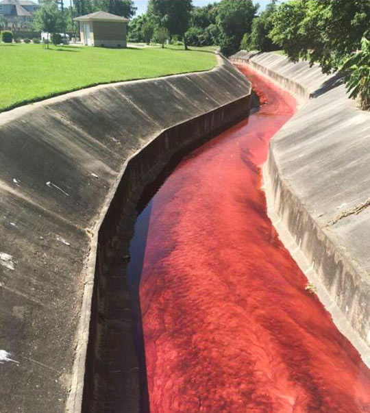
The ditches ran red in the Spring Branch area yesterday as the billowing 4-alarm fire near Laverne St. at Spring Branch Dr. triggered evacuations and shelter-in-place orders across the surrounding areas. The blaze reportedly started in a home-slash-auto-shop on Laverne and spread next door to the A-1 Custom Packaging warehouse (which transfers large quantities of various industrial liquids into smaller bottles for distribution). Some of those stored chemicals (including the bright red petroleum additive visible in the shot above) made their way into drainage ditches and culverts flowing into Spring Branch itself.
The red additive is non-water-soluble and has been getting pushed around by contract clean-up crews downstream to stop the spread. But contractors cannot, the city says, catch the pesticide that also made its way into the same drainage channels, as it dissolves in water. It’s still unclear how much of the 500 gallons or so thought to have been stored at the site made it all the way into Spring Branch (which flows into Buffalo Bayou south of I-10), but some water quality test results are due back later today.

