METRO PONDERS HOW TO SPEND A LIGHT RAIL SURPLUS 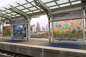 What should Metro do with the extra $39.9 million it’ll end up with after the Southeast and East End rail lines open in April (on the 11th, it now looks like)? If the money isn’t spent, it’ll have to go back to the Federal Transit Administration, reports Dug Begley. $24.9 million of that would have to be spent on projects related to the year-plus-old North Line extension (the Red line), and $14.5 million would be restricted to use on the Southeast Line (aka the Purple Line). Among the proposals: building an elevated walkway between the bus transit center and the rail line at Northline; putting in extra parking at Palm Center, at the end of the Purple Line; shelters for bus stops near stations; an additional station on the Purple Line between Elgin and Leeland; safety or operational improvements, such as a restroom for train operators at a station; a crossing arm on Texas Ave. near Chartres St. [Houston Chronicle] Photo of Burnett Station: Skyline Art Services
Tag: Southeast Line
WHY METRO TRAINS ARE ALREADY ROLLING AROUND UH 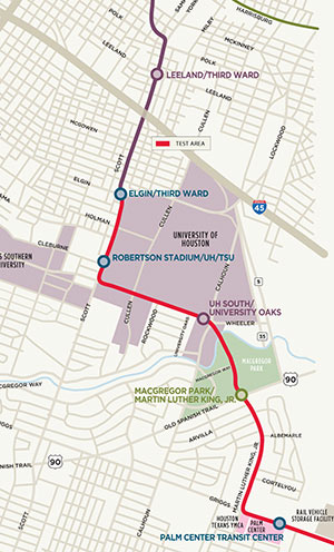 No, the new light-rail lines won’t be ready to carry passengers anytime this year — if you’re looking for a ride, check again in 2015. But over the next couple of weeks, you may see a Southeast Line train or 2 skirting the western and southern borders of the University of Houston. Starting today, Metro will be shuttling vehicles along the path shown in red on the Purple Line map at left, from the corner of Elgin and Scott Streets through MacGregor Park to the vehicle storage facility just past the Palm Center Transit Center — for safety testing. Map: Metro
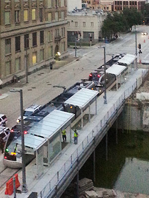 No, no one’s expecting Metro’s 2 new light-rail lines to open any sooner than late December (as Swamplot reported last week), but some progress toward that goal is now visible on portions of the East End and Southeast lines: “Live wire” or powered testing of the downtown tracks began this week. The photo at right, sent in by a reader, shows a Metro train moving unescorted along the tracks on Capitol St. for the first time.
- Southeast and East End Line coverage [Swamplot]
Photo: Nathan Juett
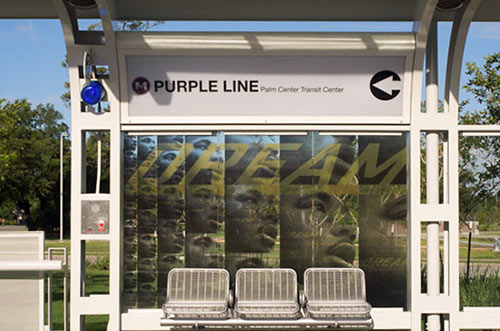
There’s still “some uncertainty” over the exact schedule, but all the pieces needed to allow Metro to open Houston’s second and third light-rail lines won’t be in place until late December, according to reports delivered to a committee of the transportation organization’s board of directors last Friday. Previously, an opening date sometime this fall had been projected for the Southeast and East End lines (though the far eastern end of the East End line won’t come on line until a newly planned overpass is built under over the Union Pacific East Belt freight rail line between the future Altic and Cesar Chavez stations). Delays in the delivery of trains aren’t the sole reason for the late openings, however.
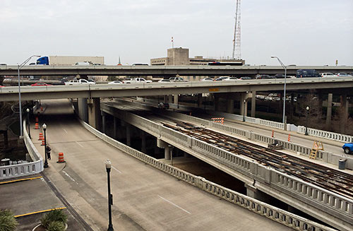
A reader who’s been watching construction of the new bridge that’s gone up over Buffalo Bayou and fitted neatly under I-45 at the far western end of the new under-construction Southeast and East End light-rail lines wonders what its purpose is. The bridge is beyond the planned Theater District stations, the last shared rail stops for the 2 lines. Is it a bridge to nowhere, or the starting point for some later western expansion along Washington Ave?
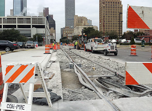
As noted in this morning’s Headlines post, yesterday Metro toted around some trains for “clearance testing” on the eastern stretches of the East End and Southeast rail lines scheduled to open later this year, in advance of electricity being brought down the lines. But downtown, repair continues on a 200-ft. stretch of track shared by the 2 lines on Capitol St. between LaBranch and Crawford — where the rails “probably shifted during concrete placement” and therefore didn’t set properly, a spokesperson for the transit agency tells Swamplot. The concrete has been torn up so the stretch can be rebuilt, level. The rework is being paid for at no cost to Metro by the contractor, Houston Rapid Transit, and will not cause any delay in opening the lines, the spokesperson says.
- East End Line and Southeast Line coverage [Swamplot]
Photo: Swamplot inbox
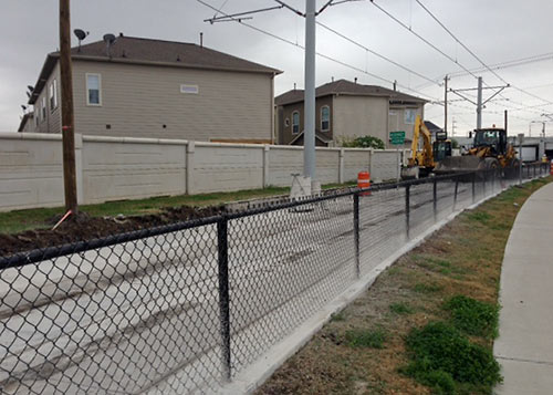
Why were crews yanking out and replacing a brand-new 240-ft.-long stretch of rail and concrete on the not-even-opened-yet Southeast Line at McKinney St. (above), next to the Columbia Tap trail in East Downtown, earlier this month? Because back on May 30th, a 7.2kV CenterPoint Energy electrical line fell onto the tracks and their overhead line three-quarters of a mile to the south, at Scott St. and Coyle St.
Zzzzzzap!
In addition to the McKinney St. burnout, 20-ft. sections of rail and track slab got zapped near crossings at Nagle St. and Elgin. At the incident site, 80 ft. of concrete and anti-vibration insulation had to be scrapped and replaced.
How far along is construction on the 3 rail lines Metro is building? A little more than a year ago, HAIF user ricco67 took a video camera along on drives following the paths of each soon-to-be rail route, and posted the results. With the completion of a video taken alongside the East End Line construction from Downtown to the Magnolia Transit Center posted yesterday (above), you can now spot-check progress in updated tours of each of them.
Ricco67’s update showing construction on the Southeast Line dates from last month:
LIGHT RAIL SCORECARD: 6 MILES DOWN, 9 TO GO, CULBERSON BLOCKING GOAL  Metro says it’s now laid 6 miles of track for the 3 light-rail lines its working on — the new East End and Southeast Lines and the North Line extension. And construction is now under way on 10 of 24 new stations. All is on track for a 2014 opening date, including $200 million of federal funds for 2 of those lines, approved by a vote in the House of Representatives last Friday. Also approved within the same bill, though: Congressman John Culberson’s ban on federal funding for both the Uptown Line and the long-delayed University Line. A House-Senate conference committee will determine if the funding block remains in the bill’s final version. [Houston Chronicle] Photo: Metro
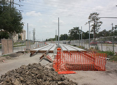
University of Houston officials have asked Metro to move a portion of the Southeast Line, currently under construction, off its planned route — and off campus. Work on portions of the line on Wheeler and Scott streets near Robertson Stadium came to a standstill 2 months ago, West U Examiner reporter Michael Reed notes. Metro and UH officials have apparently been negotiating on the layout of the light-rail route since that time, but so far, according to Reed, there’s been no agreement.
Metro’s planned design for the line requires the transit agency to purchase a total of 4.48 acres of UH property, much of it in a strip along the eastern side of Scott St., just west of the stadium. A plan submitted to the Department of Transportation for funding last year shows the line and a Scott/Cleburne station on the east side of Scott St., on part of what’s currently a stadium parking lot. (The map, below, also shows that Metro adjusted the plan from a 2008 layout that would have eaten up more UH property.)

16 of the 25 official station names announced today for Metro’s new East End and Southeast light-rail lines and North Line extension include slashes. No, you won’t need to choose between Cesar Chavez and 67th Street: The Cesar Chavez/67th St. station will honor both. Same for MacGregor Park/MLK. The term “EaDo” has made it on to a station name — but only as part of the EaDo/Stadium team — not to be called “EaDo Stadium” of course, since Spanish bank BBVA Compass just paid a lot of money for the exclusive naming rights to the new soccer venue.
A few other station names you’ll want to be careful with:
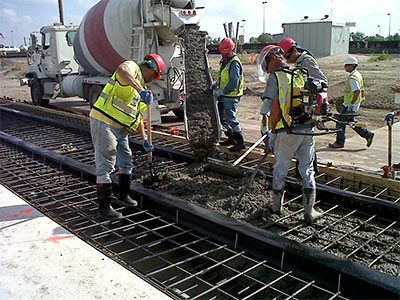
Seen at this morning’s Purple Line kickoff on McKinney St. near Ennis in East Downtown, a sight not seen around Houston since before 9/11: What it looks like when Metro contractors lay track for a new light-rail line . . . or pour the concrete pad for it, anyway.
- Metro puts down rail for first time in decade [Houston Chronicle]
- Previously on Swamplot: Metro Rail Gets Back on Track Tomorrow
Photo: Metro
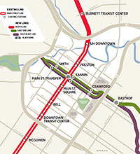 Has it really been 10 whole years since any new tracks have been laid for any Houston light-rail lines? Not exactly. It’s been 9 years and 11 months. To celebrate the occasion, Metro is holding a small ceremony tomorrow to place the concrete base for the very first tracks on the new Southeast, or “Purple” line. Tomorrow’s morning pour will take place at 2979 McKinney St. near Ennis in East Downtown, but the 6.6-mile Southeast Line will run all the way from a new station on Smith St. to the Palm Center, with stops at Fannin (change here for the existing “Red” line), Crawford (baseball, anyone?), Bastrop (soccer?), Leeland, Elgin then Scott St. (both at the western edge of UH, crossing the path of the proposed University Line), Wheeler and MLK (on the other side of campus), and MacGregor Park along the way:
If you can’t wait just those few more years to hop on the new light-rail line serving the East End, this automotive video approximation might tide you over. HAIF poster ricco67’s tracing of the drivable portions of the route from the new Smith St. station on the western edge of Downtown (shared with the new Southeast Line) to the Magnolia Transit Center provides snapshots of construction progress and a steady diet of orange construction barrels. Also available: these shorter tours showing progress on the Southeast Line and the coming extension to the existing North Line:
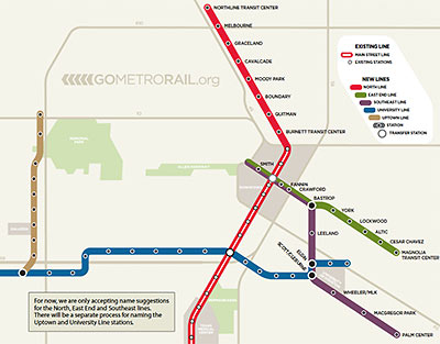
See that map up there, showing all the stations on Metro’s planned light-rail lines? Metro is asking the public for help naming those stations. But not the stations that don’t have any names indicated next to them — the transit agency isn’t quite yet ready to get to those. No, Metro wants your help choosing names for the stations that are already marked with names. Like, the “Burnett Transit Center.” What should that station be named? Anyone? Anyone? And how about the one marked “Boundary”? Any suggestions? Spicoli?
This is, of course, the best kind of call for submissions. If you can do better than what they’ve already got, go ahead! If you can’t beat what’s there already, why bother? And you can get an idea what the fallback is gonna be, if all the suggestions suck. Just think what we might have ended up calling East Downtown if that naming “contest” had been pitched like this: Yeah, we’re threatening to name this area EaDo — unless you stop us, with something better. How well would that have worked?
You can get a sense of where the stations are planned for the new North, East End, and Southeast Lines from these maps:

