04/11/08 12:05pm

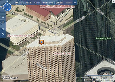
Live Search Maps Aerial View of Downtown Houston with New Street Highlighting and Labels

Microsoft has updated its Live Search Maps with a number of new features, the most striking of which is the ability to view a street-map overlay on the maps’ signature 3D aerial views. This should be especially helpful to the armchair pilots among you who have been flying blind through Microsoft’s “bird’s eye” views, trying to figure which street is which as you rotate around a property.

Since HAR’s recent update, Live Search Maps are now linked directly to property listings. However, those maps do not include the new street-highlighting feature. To see this new feature, go to maps.live.com and enter an address, then click on the “Bird’s eye” button at the top. Street highlighting automatically appears, but you can turn it off by clicking on the button at the top marked “Labels.” As before, you can rotate the direction of your view by clicking on the N, S, E, or W in the top left corner.

Now here’s a problem: What happens when the newly highlighted streets run behind a tall building? As our sample image above shows, they don’t just run — they dash!

After the jump: How to avoid traffic online!

CONTINUE READING THIS STORY

04/07/08 11:28am

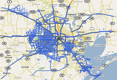
Google Street View Coverage of Houston

Last week Google rolled out a major update of its Street View feature, adding 13 new cities and a national park, and expanding its coverage in 6 cities . . . including Houston. The map above shows the extent of the Houston street-level photos now available through Google Maps.

Previously, street views from Google Maps were available only from major thoroughfares in the Houston area. Now, they are available on just about every street . . . within the areas marked in blue. South Houston, plus areas west of 290 and 288 outside the Loop are now mapped street by street. But most inside-the-loop neighborhoods are still left out.

Strangely, this means Google Map addicts can stalk Cypress subdivisions virtually street by street, but views of Southampton are limited to sideways glances from Shepherd and Bissonnet.

After the jump: a sampling of the new street-level views of westside neighborhoods!

CONTINUE READING THIS STORY

03/21/08 12:27pm

Logo for HCAD’s new iSettle Online Property-Tax Appraisal Settlement System

Who came up with the name “iSettle” for HCAD’s new online settlement system for property-tax-assessment protests? It’s a name that appears crafted to attract the most docile of protesting taxpayers — which should work out well for the appraisal district: If you’re one of those more contentious homeowners who won’t settle for iSettle’s email offer in response to your protest, HCAD staff won’t even bother scheduling an informal meeting for you with an HCAD appraiser. You go straight to a formal hearing!

If you file your protest on line using iFile and indicate a realistic opinion of value, your account may be selected for an on-line settlement offer. The appraisal district reviews the protest and its own evidence, as well as trends in reductions in surrounding properties. If your suggested value falls within those parameters, a settlement offer will be sent to you at the email address you give when you file. Normally, you will have 10 days in which to log on to the iFile website and accept the offer. If you accept the offer, you won’t need to attend any appointments. The records will be changed and you will receive confirmations via email and regular mail. If you do not accept or do not respond, your account will be scheduled for a formal hearing . . . with the appraisal review board.

If you aren’t otherwise inclined to protest your home’s appraisal in person or hire a firm to do it for you, iSettle is probably worth trying. But personable homeowners with negotiating skills who’ve been able to finagle appraisal reductions in the informal meetings may want to avoid it.

And iSettle won’t be available to everyone anyway:

The iSettle process will be available only to individual homeowners. Most neighborhoods are eligible, but a few neighborhoods are not because of the complexity of the market in those neighborhoods. If you aren’t eligible, we’ll notify you.

Heights residents: This means you.

03/11/08 5:58pm

[youtube:http://www.youtube.com/watch?v=iJm4DykNPOg 400 330]

If only Marvin Zindler had lived to see this!

Houston’s longtime consumer reporter is no longer around to deliver his stirring “Slime in the Ice Machine!” reports on TV, but Harris County Public Health & Environmental Services is now allowing online access to its database of inspection reports for retail food establishments.

Though it’s not nearly as user-friendly as, say, being able to see letter grades in restaurant front windows, the ability to search through reports online is a big step forward. And hey, now that they’re available, maybe someone can turn distributing inspection report cards to county restaurants into a business.

If you’re on the prowl for ice-machine violations in the new database, maybe to put into your own Zindler-style restaurant-inspection broadcasts on YouTube, look for “Slime on soda nozzles, soda gun & holster, ice machine, yogurt machines” under inspection item 25, “Food Contact Surfaces of Equipment and Utensils Cleaned, Sanitized/Good Repair.”

03/10/08 8:53am

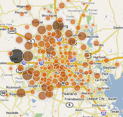
Partial View of Map from Houston Chronicle Showing Locations of Foreclosures in Houston, 2007

There’s been so much exciting news for dedicated Houston foreclosure gawkers lately. Last month’s HAR redesign added a feature that allows anyone to search current MLS listings for foreclosed properties. And now the Chronicle has put together its own database chronicling foreclosed properties by neighborhood. Plus, the paper includes the handy interactive foreclosure map pictured above, full of dancing bubbles!

A lot of that bubbly makes it look like the foreclosure corks have been popping more frequently in the outside-Beltway-8 neighborhoods, with Katy the big winner. And the map is fun to play with and click on. But don’t miss the more mundane-looking 2007 Neighborhood Foreclosure list, which allows you to sort data on neighborhoods that had 5 or more foreclosures last year, and which spills some fun real-estate secrets . . . like Tremont Tower‘s 97.37 percent foreclosure rate! Bear Creek Meadows‘s 83 foreclosures! And the Memorial Cove Loft Condos’ perfect record: 20 units, 20 foreclosures — in one year! How’d we miss that one?

If you have time to play with these fun tools, and unearth any interesting data, let us know what you find!

02/22/08 7:55am

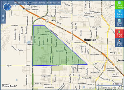
Polygon Map Search on HAR.com

The revamped HAR consumer site debuted with a splash on Valentines Day — and Houston real estate will never be the same! Over the past week, a few site quirks have quietly been ironed out (tabbed browsing now works again, for example), but there are plenty still left to enjoy. Below is Swamplot’s handy guide to some of the freakiest new HAR features — sure to excite thousands of obsessive online Real Estate voyeurs:

CONTINUE READING THIS STORY

02/05/08 11:13am

My Houston Home Page, from visithoustontexas.com

The Greater Houston Convention and Visitor Bureau’s celebrity-laden “My Houston” campaign hits the web!!! And it sure looks a lot like Facebook or MySpace, doesn’t it? All the kewl kids are on it, like Beyonce, and Yao, and AJ, and George and Barbara, and Chloe, and Yolanda. And they’re all saying great things about your city!!!

Only . . . there doesn’t seem to be a way to post your own page. Or add your comments to theirs. Or participate in any way.

All those local celebrities? They are not your friends. Clay and Brian and Hilary are not in your extended network.

Loser.

11/28/07 5:00am

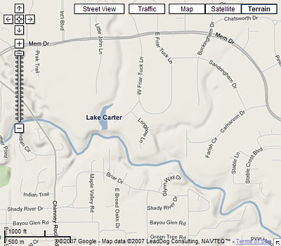
Google Maps Showing New Terrain View in Houston

Another week, another round of updates to Google Maps. Sure, there are some fun new capabilitiesgroups of people can now work together to add items to a single personalized map; thumbnail preview photos of Street View panoramas will now appear in the pop-up balloons for many commercial addresses on major streets. But for Houston, the most exciting new feature is the new Terrain view, which now reveals even to casual internet visitors the exciting topography that makes our local landscape so . . . Houston-like.

Imagine you’re a Houston newcomer scouting hilltop locations to site your dreamhouse, and want to see what views you might get from a promontory in say, Highland Heights. Simply type in a Highland Heights address into Google Maps — try 1042 Lucky St. 77088 from today’s Daily Demolition Report, for example. Sure, aerial views have been available for a while now, but what if you want to get an idea of the views from this location? Will there be a charming vista to the Cemetery Beautiful Cemetery a few blocks to the north?

With the new Terrain view, Google lets you see: At the top right of every Google map there’s now a button labeled “Terrain.” Click that and the map you’re viewing will show all the hills and level changes in the area — all of them!

Having trouble seeing those elevation differences? Hmmm . . . well, at least it makes those bayous and gullies stand out!

11/20/07 12:36pm

[youtube:http://www.youtube.com/watch?v=17YoMQLMdR4 400 330]

Real estate agents and other obsessive users of online maps will be interested to hear about a new feature introduced very recently to Google Maps, which allows you to “correct” the location indicated for a home address. As of a few days ago, the little balloons that appear above flagged locations on a map now include an “Edit” link. Clicking on that link (and signing in to Google, if you aren’t logged in already) allows you to drag a location marker to the exact front entrance of the property, and to have the corrected location appear to other users, too. You’ll need to have an account with Google to participate. The video above illustrates how it works.

Most users will probably want to adjust the marker for their own homes, and correct frustrating Google Map errors they’ve found in other locations. (The feature will likely eventually lead to a corrected map location for 14715 Quail Grove Ln. 77079, for example.)

Of course, the potential for mischief is obvious, but Google will be using a few techniques to prevent houses from sliding all over the map: First, address-marker moves of more than 200 feet won’t show up until they are approved by a moderator — and you can imagine moderators will not have very finely developed senses of humor. Google will also be relying on crowdsourcing — in this instance relying on the presumption that a plurality of online housemovers focusing on a particular address will be making changes that are actually helpful.

All of which means that if for some reason you really do want to move a house to a new location down the street, into a new neighborhood, or to another city entirely, the online world isn’t going to be so different from the offline one: You’ll need some help from friends.

08/09/07 10:42am

Downtown Houston from I-45 North, As Seen from Google Maps Street View

Google has just added its Street View feature to Houston Google Maps. This means that you too can experience what it’s like to drive around parts of this city with a 360-degree camera mounted to the top of your Chevy Cobalt—all from the privacy of your own computer.

Google first rolled out Street View in May for the San Francisco Bay Area, New York, Las Vegas, Denver and Miami. Several websites have sprung up to document interesting streetlife recorded by Google’s cameras.

For Houston, of course, Street View is much more exciting: at last, online photos of all your favorite strip centers, parking lots, and freeways. Occasionally a pedestrian gets in the way to mar a view, but most of the shots are much cleaner.