11/26/08 9:11am

Google has rolled out another update to its Street View feature, this time allowing simultaneous views of a property from the air and the street — as shown in this view of a familiar Rice Village site. The button labeled “Street View” that used to sit at the top of most maps is gone. In its place: a character named Pegman who stands at the ready above the zoom slider on the left side of each map, and who narrates this video detailing the new Google Map features:

CONTINUE READING THIS STORY

11/20/08 11:34am

This 1946 Dmitri Kessel photo of some not-long-vacant Houston property is just one of a half-million images from the Life magazine photo archives that are now only a Google search away. Google is announcing that the entire collection of photos taken for Life magazine — about 10 million in all — will be available within the next few months. About 97 percent of these images have never been seen by the general public.

The images are available from a simple Google image search. You can single out the Life images by adding “source:life” to your search or by starting at this gateway.

Houston photophile Robert Kimberly, who’s been poring through the collection, says

There are loads of Houston pictures, but add “TX” or Texas” to narrow a search to the city. Otherwise you’ll be seeing lots of “Whitney.”

Photo of sign advertising opening of Texas Medical Center, 1946: Dmitri Kessel, Life Magazine

10/23/08 9:07am

Panoramic Aerial View of Nelson Lane, Crystal Beach, Bolivar Peninsula, after Hurricane Ike

Tired of looking at the same old images of Hurricane Ike devastation? Now, thanks to the amazing aerial camerawork of Dallas’s Hawkeye Media, you can conduct your own Bolivar Peninsula post-disaster flyover, focusing only on the destruction you want to see — from the comfort of your own broadband internet connection.

Hawkeye’s interface allows you to navigate through the company’s panoramic overhead views of wasted homes and newly desolate landscapes, zooming in and out as fast as your middle finger can scroll.

Photo of Nelson Lane, Crystal Beach: Hawkeye Media

10/06/08 8:06pm

[youtube:http://www.youtube.com/watch?v=MngAUnhDDbg 400 330]

Metro says it is working with Google to add Houston’s public transportation info to Google Transit.

When will Google Transit for Houston be ready? “Sometime in November or December.”

09/22/08 8:04pm

Aerial Photo of Hurricane Ike Destruction

A company called U.S. Forensic has posted 1700 aerial photographs taken from a low-altitude airplane the company flew over southeastern Texas and Louisiana a few days after the hurricane. The photos are arranged in an overlay accessible through Google Earth, so you can import the file into the free software and search for views by address.

Even if you don’t use the Google Earth interface, the directory of individual photos provides some shocking scenes:

CONTINUE READING THIS STORY

09/17/08 4:25pm

Aerial Photo of Villa Dr., Seabrook, Texas, after Hurricane Ike

Having trouble finding photos of your Iked house on Flickr? Try finding it from the air, using NOAA’s brand-new aerial photos, taken only a few days after Hurricane Ike.

Aerial photo of Villa Dr. in Seabrook after Hurricane Ike: NOAA

09/16/08 9:44pm

Homes in Surfside Beach after Hurricane Ike

Thanks to the efforts of a volunteer firefighter, banished Surfside Beach and Surfside Shores residents may be able to view their homes on Flickr. Former New Orleans resident Adam P. Devaney has taken more than 800 photos of surviving homes in the area, though he’s only halfway through with the uploading.

Devaney, who has taken photographs as a hobby for about 10 years, said he did not zero in on the most dramatic damage, but rather tried to document the entire landscape. He estimates he has photographed bout 95 percent of Surfside Beach since Ike’s landfall.
He will try to photograph the beachside communities of Treasure Island and San Luis Pass later this week at the request of some homeowners. He tried to enter Treasure Island on Tuesday, but was turned away by Brazoria County Sheriff’s deputies, who are keeping the area off limits, due to severe storm damage.

CONTINUE READING THIS STORY

09/02/08 2:32pm

Here it is, the bastard brainy child of those old David Hockney photocollages and Quicktime VR: Microsoft Photosynth. Someday, maybe, it’ll revolutionize online real-estate gawking. For now, though, it just looks kinda cool.

08/26/08 10:02am

OFF-MAP JOGGING IN GLEANNLOCH FARMS Another lost jogger, rescued by iPhone. But what happens when Google Maps fail? “Every time I am in Houston I am filled with renewed trepidation over the in-laws neighborhood. It’s lovely, of course, but it’s also a Houston suburbs’ subdivision. Despite having visited numerous times over the course of the past three and a half years, I am remarkably unable to maintain any sense of cardinal directions or relative location once we enter the sprawling land of pale-red-and-cream houses in well-manicured cul-de-sacs with nice names.”

08/20/08 2:37pm


Houston’s Downtown wireless-access experiment is now up and running, with a network of 20 free hotspots, identified in the city’s interactive map above. The hotspots offer download speeds of up to 2Mbps and uploads of up to 1Mbps, which is in the ballpark of cable and DSL service. Brave iPhone tester (and Chronicle Tech columnist) Dwight Silverman reports coverage is pretty spotty between Wi-Fi hotspots:

I’d get a decent signal on my iPhone in one block, then turn a corner and get bupkis. But if I walked a few more feet, I could usually get enough of a connection that I could check e-mail.

Silverman also offers this tip:

If you want a good connection and you’re not near a hotspot, look for one of the dual-antenna access points mounted atop street lights. Get close it for a stronger signal.

Map: Houston WiFi

08/15/08 12:13pm

Welcome Center, Department of Health and Human Performance, University of Houston Second Life Campus

The University of Houston is buying an island on Second Life! It’ll be used for the school’s Department of Health and Human Performance and the Texas Obesity Research Center.

Plans call for an interactive campus where students and professors adopt avatars to walk (or fly) around campus or teleport to any number of thousands of other islands.

Virtual doesn’t come cheap. UH paid $1,700 for the island and pays Linden Research another $300 a month in rent.

Not cheap?? You try renting an entire campus for $300 a month. You could hardly get a dorm room for that. But the best thing about UH’s new space is clearly its high quality design.

A virtual architect designed and built the campus as a very, very loose replica of the real thing “with better architecture,” says Associate Professor Brian McFarlin.

After the jump: More views of the beautiful UH-Virtual!

CONTINUE READING THIS STORY

08/06/08 1:08pm

Map Showing Coverage of Google Street View in Houston

When the Street View feature was first introduced to Houston Google Maps about a year ago, it allowed viewers to follow street-level photos . . . mostly along major thoroughfares. In March, Google added street-level views of residential neighborhoods within a huge swath of West Houston and Pasadena . . . but the update still left out most areas inside the Loop.

This week, a tipster informs us, Google has expanded Street View again, updating its database with photos taken from almost every street inside the Loop . . . and this time including most areas inside the Beltway and beyond as well. The map above shows the extent of the new coverage.

Smile! Photos of your home are likely now on the internet . . . unless you live in a few special areas in town . . .

CONTINUE READING THIS STORY

05/30/08 12:35pm

Map of Houston Subprime Loans in 2006 from PolicyMap.com

Here’s a tool likely to be useful to armchair developers interested in the lay of the land. PolicyMap is a new GIS website that allows you to view a range of local market and demographic data for Houston or any area of the country. You can see how local crime statistics, an interesting array of mortgage categories (such as the percentage of piggyback, subprime, and refi loans), income distributions, and even donations to presidential candidates look on a map. (Big surprise: Pearland and the Energy Corridor really like John McCain!)

PolicyMap is a project of The Reinvestment Fund, a non-profit community-development financial institution from Philadelphia. Some of the advanced features require a subscription, but there’s plenty to play around with for free.

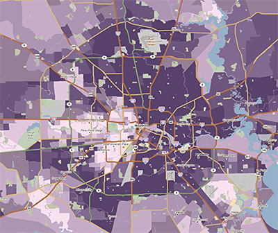
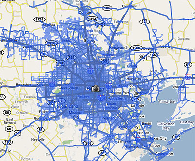
The quick map above shows what Houston areas took out the most subprime loans in 2006. (The darkest purple means more than 50% of all mortgages funded that year.) If you discover more interesting neighborhood stories demonstrated nicely in PolicyMap maps, share your finds in the comments.

04/30/08 3:42pm

Turn by Turn Directions with Google Street View

Google has just added street-level photos to the driving directions available on Google Maps. This means — if you’re headed through an area covered by Google’s Street View — you can now use photographs of each intersection to guide your journey, with helpful arrows superimposed to show your path.

Though the areas covered by Street View in Houston were recently expanded, most inside-the-Loop neighborhoods are still not covered. Let’s say you’re at the new Pagoda Vietnamese restaurant near Cottage Grove, trying to find your way to Chinatown — you know, that neighborhood on Bellaire in southwest Houston, where all those Vietnamese restaurants are. If you plot your trip using Google maps, the directions won’t show photos of your first few turns. From I-10 on, though, you get preview photographs of every intersection. And you can pan and zoom around them, as if looking for oncoming traffic.

After the jump: A video from Google, showing how Street View directions work . . . and what they’re good for.

CONTINUE READING THIS STORY