COMMENT OF THE DAY: THE SLICE OF HOUSTON WHERE NOBODY’S HOME “I did NRFU (Non Response Followup) surveys for the census in the wedge between 45 and the Ship Channel and this doesn’t suprise me at all. LOTS of people don’t answer the door. Lots more told me of one, two, or three residents when in fact an evening visit’s observations yielded six or eight.” [Some d00d, commenting on Houston to Census Bureau: Count Again]
Houston Ship Channel

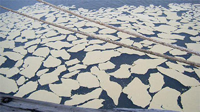
Having perhaps worked its way through the 100,000 gallons of raw sewage dumped into Buffalo Bayou shortly before New Year’s, the Houston Ship Channel received an additional contribution late yesterday: 15,000 gallons of beef tallow, which leaked into the waterway from a storm drain. There is, of course, much more where that came from: a rupture in an onshore tallow tank owned by a California company called Jacob Sterns and Sons caused 250,000 gallons of animal fat to spill on the waterway’s northern banks. A three-quarter-mile stretch of the channel — from City Dock 16 to the Buffalo Bayou Railroad Bridge — has been closed.
Some video of the scene, where six boats have deployed boom, from abc13:
HEADWATERS OF THE HOUSTON SHIT CHANNEL A sewer collecting system on the northern banks of Buffalo Bayou near Lockwood donated more than 100,000 gallons of untreated waste to the waterway last night. City officials expect the problem to be fixed sometime today. [MyFox Houston]
THE LUNCHTIME RACKET AT BRADY’S LANDING Visiting the Houston Ship Channel on a promotional “toxic tour” of sites where the air will likely be invigorated once nearby refineries get chugging on the Canadian tar sands headed for Houston through the proposed Keystone XL pipeline, Perry Dorrell stops by the scenic Brady’s Landing Restaurant during lunchtime: “During the evening the restaurant is like many others in the city: bustling with patrons and staff, the parking lot busy with diner traffic. During the day, however, the region’s oppressive noise is invasive and obnoxious; right next door a facility is dry-docking barges and a team of several men operating industrial-grade pressure washers removes barnacles from their hulls. Cranes swing containers to and from foreign freighters, crashing and booming. The warehouses directly across the channel are beehives of activity, with stevedores operating forklifts, shifting and stacking and slamming pallets of material. It was amazing how loud it was, a phenomenon I never noticed in my visits at night to dine. On the other side of the restaurant a steamshovel was loading and unloading a smoking, 200-hundred-foot high brown pile of … something, fertilizer-like in appearance. No accompanying aroma, fortunately. Maybe we were upwind.” [Brains and Eggs; previously on Swamplot]
HURRICANE IKE’S LOUSY AIM Director Phil Bedient comments on a report released today by Rice University’s Severe Storm Prediction, Education and Evacuation from Disasters Center (SSPEED): “‘Ike was a Category 2 hurricane, and it caused $30 billion in damage. Had that same storm struck 30 miles farther south, it could easily have caused $100 billion in damage. Had it struck that location as a Category 4 storm, like Carla, the results would have been catastrophic.’ . . . Bedient said one need look no further than the Houston Ship Channel to get a clear sense of the region’s vulnerability. The ship channel is home to one of the nation’s busiest ports and about one-quarter of U.S. refineries. The Coast Guard estimates a one-month closure of a major port like Houston would cost the national economy $60 billion. Despite this, government regulations require dikes and levees that can protect ship channel facilities against only the 100-year flood of 14-15 feet. Bedient said that based upon results from supercomputer models at the University of Texas, Austin, Ike could have caused a 20- to 25-foot storm surge along the ship channel if it had struck about 30 miles farther south.” [SSPEED, via Memorial Examiner; report (PDF)]
Ready, at last, for the small screen: This lingering aerial tour of Houston’s rich natural and nature-processing landscape, straight from last year’s Center for Land Use Interpretation exhibit on Texas Oil.
Put on your headphones, turn up the volume, and take it all in!
Our journey takes us east from the 610 Loop and ends at the liftoff point for the Fred Hartman Bridge at Highway 146. When they gonna come back and give us some Baytown?
- Houston Petrochemical Corridor Landscan [Vimeo]
- Texas Oil: Landscape of an Industry [Blaffer Gallery]
- Previously on Swamplot: CLUI in Houston: Attack of the Pod People, CLUI Houston Residency: Open to Interpretation
Video: CLUI
COMMENT OF THE DAY: AND ON ANY RAINY SUNDAY “Well, Christmas Day and New Year’s Day are coming up, an opportunity for the Annual Unscientific Anecdotal Take A Whiff Holiday Bingo. First thing in the morning on these two holidays, open your windows or step onto your porch or balcony, face the southeast, and take a big sniff of the air. 99% guarantee you’ll get a strong odor of Eau de Ship Channel. After 20 or so years of this I’m convinced that the plants take advantage of the holiday (no one manning the phones at TCEQ) to flush the toilets, as it were, and let the emissions fly.” [Miz Brooke Smith, commenting on How the TCEQ Helps Houston Air Stay So Fresh and Clean]
THE GIFT OF BENZENE What’s that faint, slightly sweet smell in the air? More from Chris Vogel’s report on Houston’s industrial emissions: “According to the City of Houston, a six-month survey in 2008 showed that six out of seven air monitors near the ship channel detected benzene levels above what the EPA says can cause cancer in ten out of every million people. That’s ten times higher than what is considered an acceptable risk. ‘Until recently I didn’t even know they were releasing any benzene into the atmosphere,’ says Dr. Charles Koller, a leukemia specialist at MD Anderson. ‘It’s shocking to me. It seems, frankly, criminal.’ It can take more than ten years for anemia to develop in someone who has been exposed to benzene, says Koller, and even longer for leukemia. A person also needs to be genetically susceptible. ‘We don’t know how susceptibility works,’ he says, ‘we just know that it works.’ . . . ‘Once benzene gets in the air,’ [Koller] says, ‘it’s everywhere. So even in Katy, there’s someone who, if they’re susceptible, will get [sick] from what’s going on in the Houston Ship Channel.’” [Houston Press]
FAILING THE PARTICLE BOARD REVIEW Levels of soot in Houston now exceed the EPA’s longstanding annual limit: “The area of concern is along the Ship Channel, the only place in Texas where levels of the tiny particles surpassed the EPA’s annual limit from 2006 to 2008, according to the most recent data available. The agency uses a three-year average to determine whether an area is in compliance. Monitoring shows air near the Ship Channel is getting cleaner, thanks in part to new rules for idling trucks and the paving of gravel parking lots. But EPA and local officials don’t know whether the improvements will be enough to drop the rolling average below the annual limit of 15 micrograms per cubic liter of air, since that average includes higher 2006 levels.” [Houston Chronicle; previously on Swamplot]
And now, a rare look at the Second Ward’s indigenous Ship Channel dance ceremony, performed along the gentle banks of Buffalo Bayou and celebrating the bountiful fall harvest of crushed concrete.
- Tetsujin [Vimeo]
Video: Freneticore
Houston ship pilot Louis Vest assembled this video from more than 2000 still photos he took on a 3 1/2-hour journey on a 600-ft.-long Panamax tanker navigating the Houston Ship Channel:
The ship was only moving at 5-6 knots for the first half of the trip and up to 10 knots in the open areas away from the docks. The journey begins just below the Port of Houston turning basin at the end of the channel and continues down to Morgan’s Point at the head of Galveston Bay. We still had 32 miles to go to get out to the pilot station in the Gulf of Mexico at that point.
Vest fastened his Nikon D700 to an outside rail and set it to take a photo every 6 seconds.
What does this trip look like in the daytime? Vest made a similar video last year (high-res version).
- Night Run II [YouTube, via Houstonist]
- Night Run II, 1st Half [Flickr]
- 500 Knots on the Houston Ship Channel [Flickr]
SOOT’S US Some public-health and environmental groups are complaining that Houston isn’t getting enough respect for the particularly fine quality of the air here, and are asking the EPA to give this city the recognition it deserves: “Houston’s concentrations of soot — a piercing mix of airborne matter from diesel exhaust, industrial flares and road grit, among other sources — exceeded the EPA’s yearly standards from 2005 to 2007, according to the most recent federal data available. . . . ‘Residents of Houston are breathing unhealthy levels of soot pollution,’ [the NRDC’s John] Walke said in an interview this week. . . . Soot has been a special concern near the Houston Ship Channel, which is home to heavy industry and a busy port. It’s the only place in Texas where the particulate-matter levels exceed the annual standard.” [Houston Chronicle]

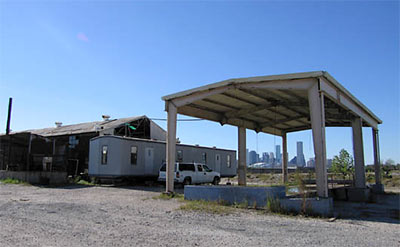
Uh-oh. That trailer — behind the pole barn — on a former scrap yard — next to the Houston Biodiesel plant — on Buffalo Bayou — may look innocuous. But it’s the new temporary Houston outpost of Los Angeles’s Center for Land Use Interpretation. The CLUI is taking up a year-long residency at the Cynthia Woods Mitchell Center for the Arts at UH — but this is where our L.A. visitors will be camping out.
What does the CLUI do? Some sample CLUI projects:
- “On the Farm: Live Stock Footage by Livestock:”
In this exhibit, farm animals show us their point of view through wireless video cameras installed temporarily on their head and necks by virtuoso animal and plant videographer Sam Easterson. Easterson’s technology enables a cow, a pig, a goat, a chicken, a sheep, and a horse to guide us around their world; what they look at, what catches their attention, how they move through space, and how they relate to one another, on the farm.
- “A View Into the Pipe,” an exhibition devoted to Los Angeles’s main sewer line.
- “The Best Dead Mall in America,” a photographic exhibit of the Dixie Square Mall in Harvey, Illinois, “a decaying shopping mall shuttered since 1979.” The exhibit is on display permanently . . . inside the mall itself, and is not open to the public.
You get the idea. CLUI’s front man is artist Matthew Coolidge, whose act often incorporates academic-sounding narrations of landscape slide shows.
Here’s video of part of a Coolidge performance at the Aurora Picture Show late last year:

