EPA: YEAH, BETTER CLEAN OUT THE DIOXIN PITS FROM THE SAN JACINTO RIVER NOW THAT THEY’VE LEAKED A bit later than had been urged by those alarmed by the longterm presence of pits full of toxic waste sealed only with a tarp on top hanging out in the San Jacinto River, the EPA has now approved a plan to remove most of the dioxin stored within them. “As exemplified today, EPA is prioritizing Superfund clean-up by making decisions in a decisive, timely manner,” reads a statement from administrator Scott Pruitt released this afternoon. “The San Jacinto Waste Pits site was added to the National Priority List nearly a decade ago.” What’s the rush? As predicted by EPA studies and many a casual observer, the pits appeared to have leaked extensively after Hurricane Harvey flooding. Under the new $115 million plan, cofferdams will be installed around the pits and almost 212,000 cubic yards of dioxin-contaminated material will be excavated — leaving just enough behind that the agency can, it says, ensure controls that will “prevent access, eliminate off-site migration, and monitor the natural recovery into the future.” [EPA; more info; Houston Chronicle; previously on Swamplot] Video of waste pits after Harvey flooding: Greg Moss
Tag: Superfund Sites
Captured on Sunday between bands of Harvey downpour by an enterprising drone photographer hunkering in Friendswood, the video above includes a quick pan over the Brio Superfund site south of Beamer Rd. near the intersection with Dixie Farm Rd. The former chemical facility, once at the heart of both the long-gone Southbend neighborhood and of the series of lawsuits filed by Southbend residents over contamination-related birth defects and illnesses, makes its cameo around minute 3, as the drone passes over a waterlogged Exxon Mobil station and rotates from south to east down Beamer toward the San Jacinto College South Campus.
Might floodwaters flowing across the Brio site and all those other Superfund spots dotting the local map have stirred up toxin-laced sediments and spread them around? (Texas A&M Galveston scientist Wes Highfield was worried enough about the possibility to attempt a mid-flood outing from his home to try to get some water samples.) In the video, the Brio site appears to be a little less waterlogged than some of its surroundings — including the adjacent section of Beamer Rd., shown picking up a bit of kayak traffic — but likely got washed over by around 42 in. of rain altogether in the past week.
In a follow-up drone run flown on Wednesday, the site (making an appearance about 2-and-a-half minutes in) looks like it might have dried off a bit:
Weather permitting, an area along the edge of the San Jacinto Waste Pits Superfund site under the I-10 East bridge should be getting around 800 cubic feet of new rocks piled onto it this week and next, according to this month’s EPA update on the project. The agency asked International Paper and McGinnis (which might be on the hook financially for much of the final cleanup) to cover up some recently-discovered areas of the nearby riverbed that were scoured as deep as 8 feet in some places by this spring‘s torrential flooding; the tarp-with-rocks-on-it armored cap itself doesn’t appear to have been damaged, but the EPA says the extra rocks will help ensure its continued protectiveness.
YOU MIGHT WANT TO TAKE THAT DIOXIN OUT OF THE SAN JACINTO BEFORE A HURRICANE DOES IT FIRST 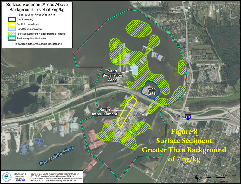 Yesterday marked the start of the 60-day public comment period on this week’s proposal to pull about 202,000 cubic yards of dioxin-laced muck out of the San Jacinto River near I-10. The Houston Chronicle editorial board was among the first to jump in (though not through official comment channels), highlighting the EPA’s conclusion that the waste, which has already been seasoning the seafood and (potentially) the river’s swimmers and nearby residents since the 1960s, could cause much larger problems if the wrong storm or hurricane hits the site; the board also calls out International Paper and Waste-Management-affiliated McGinnis Industrial Maintenance — companies potentially on the hook for the cleanup bill — for purportedly slowing down the cleanup process. [Houston Chronicle; previously on Swamplot] Map of higher-than-background dioxin levels near San Jacinto Waste Pits site at I-10: EPA

 Yesterday the EPA released their recommendations for what to do about the toxic muck in the San Jacinto Waste Pits, after more than a decade of local and federal agencies poking and fishing around in the area (on either side of the I-10 crossing of the river). So far the Superfund site has been temporarily dealt with by the 2011 placement of a pretty-much-just-a-tarp-with-rocks-over-it armored cap, which the EPA says has already been repaired at least 7 times; the document released yesterday notes, however, that disturbances at the site caused by weather and previous nearby sand mining operations “could cause a catastrophic release of the highly toxic waste materials from the impoundments, if they remain in place.”
The EPA wants to remove about 202,000 cubic yards of contaminated material (roughly enough to fill the floor of the Astrodome with a 13-foot-deep layer) but says it’ll have to be done carefully so as not to accidentally stir up the waste into the surrounding river while trying to get it out; the removal would also probably take place in stages to avoid potentially exposing too much of the waste at a time to storms or flooding. Here’s the EPA’s map of the 2 sites where the paper sludge was originally dumped in the 1960s — the (capped) northern area is outlined in blue and labeled Cap Site, while the southern site (outlined in yellow and labled Southern Impoundment) is covered in part by the Glendale Boatworks building, next to Southwest Shipyard:

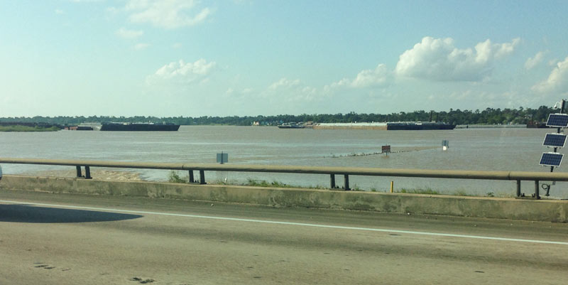
 Another effect of the Memorial Day weekend and early June floods: the EPA says it has had to pause some of its latest study efforts near the 1960s industrial waste pits in the San Jacinto river (shown at the top looking a bit more submerged than usual on May 31, facing north from the I-10 bridge). New rounds of sample-taking were triggered by the discovery in December that the Superfund site’s armored cap (which is made of special tarp material held down by a layer of rocks) had a 25-ft.-long hole where the rocks were missing. The EPA also notes that the damage was found within an area of the cap where no tarp was actually initially placed, in light of concerns that the rocks would slide off of it.Â
EPA ASKS FOR NEVADA’S HAND IN CLEANING UP RADIOACTIVE GROUNDWATER AT BP’S ANACONDA MINE Meanwhile, in Yerington: The EPA is pushing to place Nevada’s Anaconda Copper Mine on the Superfund list, after 15 years of investigating the area’s uranium-contaminated groundwater and a nearly $20 million resident settlement: a 2013 class-action suit accused mine owner Atlantic Richfield and parent company BP America of intentional and negligent concealment of the extent of contamination from the site. The EPA sent a letter to Nevada governor Brian Sandoval last week, giving the state about a month to respond with any concerns about the intended listing. Nevada has previously fought the listing of the site 65 miles south of Reno, hoping to avoid drops in property values. In 2004, former Anaconda cleanup supervisor Eddie Dixon was fired by the Bureau of Land Management for alienating groups that help the agency to work “in an efficient and effective manner” — a 2008 panel upheld that Dixon was actually fired for insisting that health concerns be publicized. Dixon also documented irregularities like changes to content in his presentations by company marketing consultants. (Some dozen Superfund NPL sites are listed around the Greater Houston Area, including sites adjacent to or within a few blocks of 610 North, 610 South, and I-10 east of downtown.) [NYTimes, High Country News, Houston Chronicle, previously on Swamplot, HBJ]
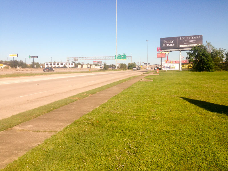
On your way home from checking out the new UT campus site, you might pass by 1 of the 6 Superfund sites located within Beltway 8 — but you almost certainly won’t notice. Just across the Sam’s Club parking lot from the former home of Astroworld, the Sol Lynn/Industrial Transformers site (tucked behind the brush-covered chainlink fence on the right, in the photo above) has no signage identifying it as a project on the EPA’s National Priorities List for cleanup. The little site at Knight Rd. and the 610 feeder is surrounded on two sides by an innocuous grassy lot:
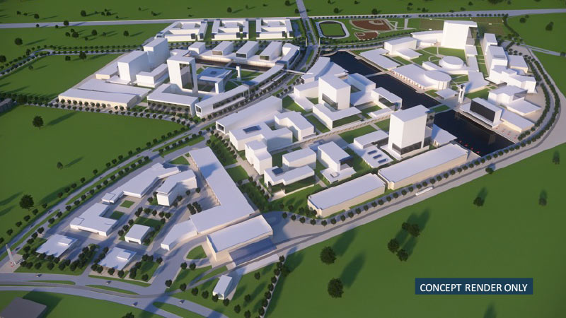
Some zoomy conceptual renderings of the University of Texas’s coming Houston campus, centered on the largely undeveloped intersection of Buffalo Spdwy. and Willowbend Blvd., made their debut at last month’s Board of Regents meeting, where the intended purchase of land for the project was announced. Buffalo Spdwy. gently winds through the drawings of the new campus to a track and several baseball diamonds along Holmes Rd. (which runs horizontally across the top of the image above).
Although the images are only “concepts”, the pictures do provide a sense of how the campus might unfold: For example, that linear water feature shown at the center of the campus aligns with an existing drainage ditch on the property, and the 3 long, low structures in the foreground are good candidates for parking garages, which will be needed regardless of the new institution’s yet-to-be-decided purpose.
Existing residential communities and industrial parks are here rendered as sparsely-treed fields — the boundary of the land slated for purchase by UT currently houses several apartment complexes on the north side and the Orkin Industrial Surplus facility to the south.
But another conceptual rendering (this one looking northwest across Holmes Rd. towards the distant Williams Tower) shows the campus in place amongst some of its eclectic neighbors:

