COMMENT OF THE DAY: WHY THINGS LITERALLY LOOK BRIGHTER ON HOUSTON’S HORIZONS  “Actually, Houston has substantially improved both air and water quality in the past few decades. I remember the haze days back in the early 90’s when you could not see more than a few miles through the smog when driving down the Katy Freeway, nor could you see the tops of the taller buildings. Also, nearly all of the illegal water pollution sources have been permitted and/or rerouted into treatment systems. The ones that haven’t are eventually caught and have to pay hefty fines, or the responsible people go to jail. It is true that much of the improvement was driven by federal and state regulation that trickled down to Houston, but that is true for most major cities.” [Superdave, commenting on Comment of the Day: Making Sure the House Wins Houston’s Toxicity Gamble] Illustration: Lulu
Sign up for the Newsletter
Quicklink

WAXING POETIC OVER THE DEMOLITION OF AN ALLEN CENTER SKYBRIDGE  “The age of confinement is over,” pens Realty News Report editor Ralph Bivins this week in his first foray into real estate poetry. Bivins was moved to verse by the details released last week on the upcoming redo of the 3 Allen Center towers at Smith and Dallas streets — more specifically, by the fact that Brookfield’s plans for the site includes the removal of one of the skybridges between One and Two Allen Center, as well as the earthen berm beneath it. The demo will turn the long-sequestered landscaped green space between the buildings into a street-accessible events lawn. The rest of the poem, entitled A quick verse by R. Bivins for Kenneth Schnitzer, Texas Eastern and the prior generation of downtown development, can be read here. [Realty News Report; previously on Swamplot] Rendering of planned Allen Center redo: Studio AMD

COMMENT OF THE DAY: EXCAVATING ELECTION PROCEDURES IN THE LOST CITY OF HOUSTON HEIGHTS 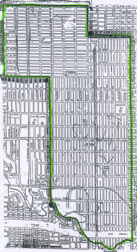 “OK, here’s where things get complicated. The current Alcoholic Beverage Code and Texas election law only provide for the possibility of holding a local option election in a county, municipality or JP precinct. It is therefore not clear that the application for a petition can be accepted as written, since the ‘area formerly known as the city of Houston Heights’ is none of those things. To complicate matters further, if the application were re-submitted as covering Harris County Precinct 1 (which covers the entirety of the dry area), it may still not resolve the matter. Current law essentially says that, for the purposes of local option elections, the vote of a justice precinct doesn’t prevail over the vote of a city, independent of date of election. So the 1918 prohibition election would trump the 2016 local option election. There’s a reasonable reading of this that indicates the only way to allow alcohol sales in the dry Heights is a local option election for the entire city of Houston. Since petitions require a number of signatures exceeding 25 percent of the votes cast in the last general election, the petitioners would need many more signatures than there are actual residents of the affected area. Good luck with that.” [Angostura, commenting on Somebody’s Trying to Legalize Beer and Wine Sales in the Heights Dry Zone] Map of Heights Dry Zone: HoustonHeights.org

COMMENT OF THE DAY: MAKING SURE THE HOUSE WINS HOUSTON’S TOXICITY GAMBLE  “Its very clear that the east side of town has the largest concentration of known pollution release points (permitted and otherwise). However, you can also easily see that there are corridors extending to the north, northwest, and south. They follow the most active freight rail lines, and the heavy industry that got built up all around them. And then there’s hazmat stuff like this, which can be located basically in any warehouse, office warehouse, distribution center, or manufacturing facility in any part of town — and it won’t get onto the map. (Remember the explosion in West, TX? Not gonna be on the map.)  . . . If you want the best odds on avoiding all that stuff, then find yourself a relatively new neighborhood that was built as greenfield development, check historical imagery on Google Earth to confirm what was there previously, buy a house in the interior of it, and be sure that you’re getting your water from a large, well-run water system. You should never drive into the city for any sort of business, civic, or educational function without donning a gas mask, and you should bring bottled water from home. Or you could just accept that there are some risks in life and balance them with the things you value — whatever that may be.” [TheNiche, commenting on That Blood Red Stuff in the Bayou May Not Be Spring Branch’s Biggest Problem Right Now] Map of Houston area Superfund sites: EPA Enviromapper

UTAH’S MALAWI’S PIZZA TO PLANT FAKE TREE NEXT TO DOUBLE MATTRESS FIRM IN SIENNA PLANTATION 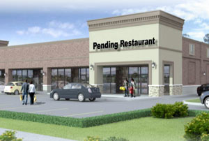 Malawi’s Pizza (which currently has 3 locations sprinkled along a stretch of northern Utah between Salt Lake City and Provo) is planning the first of some 20 Houston-area locations, writes Katherine Feser. The fast-casual-with-fine-china chain’s main shtick, other than the life-size acacia tree model in each restaurant? The company says it donates nutritional supplements and allotments of grain to folks in Malawi in proportion to the number of pizzas sold each month. The first Houston spot is planned for 8731 Highway 6 Center (a new retail strip immediately west of the double Mattress Firm on Highway 6) in Missouri City.  Another location may be on the way to Central Square in Midtown; the company says it hopes to open 4 Houston-area locations by the end of 2017, while also expanding to Dallas and Virginia. [Houston Chronicle] Rendering of Highway 6 Center: Hunington Properties

UBER AND LYFT PULL OUT OF AUSTIN, PREPARE FOR CAPITOL Meanwhile, in Austin: Uber and Lyft ceased operations today after a city proposition to overturn requirements for drivers including fingerprint-based background checks was shot down by voters over the weekend. The measure was blocked by 56 percent of the vote, despite $8.6 million in campaign spending by the 2 rideshare companies. State senator Charles Schwertner immediately promised to file state legislation to overturn the matter during next year’s session, implying that the Austin rules (which are less stringent than those required by Houston) are “for the sole purpose of stifling innovation and eliminating competition.†El Paso state representative Joe Pickett, however, suggested that “the most minimal thing that state government could do” would be to leave the issue up to individual cities. [Austin-American Statesman; previously on Swamplot]
RAVEN TOWER’S TOWER TEMPORARILY CLOSED, BUT THE SHOWS WILL GO ON 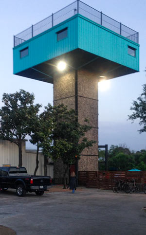 The blue bar-on-a-stick at the northwest corner of the White Oak Music Hall complex temporarily shut down last week so W2 Development Partners can add more railings and make the space more physically accessible. The elevated 1970s former bachelor pad reopened as a bar and rooftop patio in January, 3 months before the first show on the semi-temporary main stage next door; a set of concrete stairs wrap around the elevator shaft leading up to the main space.  The non-tower sections of the Raven Tower venue, including the downstairs bar and the outdoor patio and performance space, are scheduled to stay open and host concerts as planned. Across the parking lot, White Oak Music Hall has another lawn concert scheduled for tomorrow night. [Houston Chronicle; previously on Swamplot] Photo of Raven Tower: Swamplot inbox

GOOD THING SPRING BRANCH HAD ALL THAT FLOODING LAST MONTH 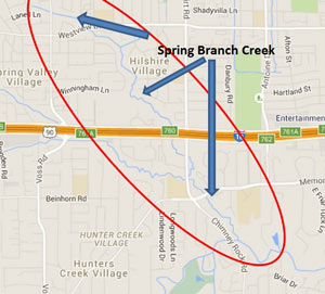 A press release from the city notes that last month’s flooding may actually make the chemical spill caused by yesterday’s warehouse fire significantly less of a problem for the waterways around Spring Branch: “Fortunately, recent heavy rainfall and flooding has caused high waters in our creeks and bayous. This will assist in diluting the pesticide contaminates and minimize its impact.” Harris County Flood Control District says the areas of Spring Branch creek marked in the map above (from the site of the fire to the creek’s junction with Buffalo Bayou) should be avoided. [City of Houston; previously on Swamplot] Image: Harris County Flood Control District

WHERE THE HECK IS HOUSTON’S BIOTECH BOOM? 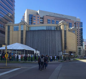 Almost $3 billion in new construction projects are underway in the Texas Medical Center, says Roxanna Asgarian in last month’s Houstonia. The district is known as the world’s largest cluster of medical practice and research facilities — but “what the TMC is not known for,” writes Asgarian, “is turning that research into new drugs and devices . . . The situation is, in many respects, baffling. All the major building blocks for a thriving biotech industry exist here, including huge clinical and research institutions, world-renowned physicians and researchers, highly skilled engineers, and a bustling business community. So what’s missing?” [Houstonia] Photo of Texas Medical Center Commons parking garage at 6550 Bertner Ave.: Texas Medical Center

ANY TAKERS FOR E-DOW? 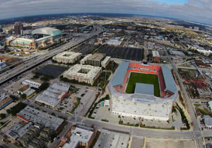 Reader and aspiring appellative linguist Bradley Rampp writes in seeking insight on “a serious question:Â How do you pronounce EaDo? I’ve always said E-dough. The Metrorail calls it E-dew.” Photo of East Downtown near EaDo/ Stadium Station on the Green Line: Russell Hancock

ENTIRE LOUISIANA ISLAND POPULATION TO BE TRANSPLANTED WITH FEDERAL ‘CLIMATE RESILIENCE’ FUNDS Meanwhile, in Isle de Jean Charles: Planning is currently in the works to resettle roughly 60 people following the gradual disappearance of more than 90 percent of their island due to a combination of industrial and climate change factors, including sea level rise, subsidence, erosion along manmade channels, and the blocking of wetland-rebuilding sediments by levees and other flood-control structures. The community, mostly members of the Biloxi-Chitimacha-Chocktaw tribe, is frequently blocked by flooding from jobs and schools on the mainland. In January, the first-ever  federal National Disaster Resilience Competition awarded $92 million dollars to the state of Louisiana, which has lost nearly 1,900 square miles of coastal land since the 1930s. Some of the money will go to the Isle de Jean Charles move, and the rest will seed a state fund to help finance other coastal “resilience” projects anticipated in the coming years. A total of $1 billion dollars for similar projects was awarded through the competition to 13 applicants (8 states and 5 communities); the city of New Orleans received a separate grant for $141 million. [New York Times, U.S. Dept. of Housing and Urban Development]
COMMENT OF THE DAY: TRACING THE ROOTS OF THE HOUSTON GRID  “The Republic of Texas in 1837 created various categories of immigrants in order to assign land grants. The coastal regions and plots fronting major rivers were for the most part already claimed by settlers that had arrived under Mexican governance, so what was allocated for new settlers was primarily west and north of the coast and between rivers. Most of these grants were made in 640-acre (1-square-mile) increments (or double or half that). These were made as geometrically regular as possible given natural features. In the nearly-featureless prairies west of Houston and notably in the Katy Prairie, you had these perfect grids dominating much of the plat maps. Roads and fences were built to follow that pattern for obvious reasons. The legacy of this system has shaped policy ever since.” [TheNiche, commenting on Ring Around the Katy Prairie, and Other Orbital Highway Fun] Map of previously planned thoroughfare routes across Katy Prairie Conservancy preserve: Harris County Planning and Infrastructure Department

COMMENT OF THE DAY: WHEN NOT ZONING BECAME BOLD NEW HOUSTON TERRITORY  “. . . Nobody can deny that Houston does things differently, but it does these things in part by not doing something that every other major city does — by bucking the trend despite repeated opportunities to go along with that trend. Houston is so notable in this regard that the Wikipedia page on ‘Zoning in the United States’ has 2 sections of text about the history of zoning: ‘Origins & History’, and ‘Houston’. . . . Houston is the one and only control case that exists by which the impacts of zoning can be tested. To my mind, this qualifies as innovation. Zoning may have been innovative when it was first tried in NYC in 1916, I’ll also grant that — but it’s precisely 100 years later, and — now — Houston’s position is innovative.” [TheNiche, commenting on Houston’s Counterintuitive Optimism; San Jacinto Mall Redo] Illustration: Lulu

CITY RESPONSES TO UBER THREATS CITE BACKGROUND CHECK CATCHES, DATA UBER SUED TO KEEP PRIVATE 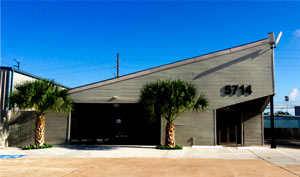 Mayor Turner held a press conference this week in response to Uber’s current PR push regarding Houston’s licensing requirements on Uber drivers. The rideshare company and ubiquitous favorite ‘[blank] of [industry]’ fill-in is threatening to pull out of Houston over the city’s rule that drivers must pass more stringent (specifically, more fingerprint-requiring) background checks than what Uber internally requires. Turner says the city’s checks have turned up criminal history in applicants already OK’d by Uber’s screening processes, including charges for DWI, assault, and murder. Meanwhile, city administrator Lara Cottingham tells Michael Barajas that Uber’s claims of drivers waiting 4 months for city licenses are exaggerated; the actual normal wait is a few weeks, Cottingham says, but the city can’t release data to support that because Uber sued in 2015 to block open records requests regarding its business practices. “The number of drivers is increasing, their revenue is increasing, everything seems to be working out for them very, very well,†said Cottingham, adding that because of the lawsuit she “can’t tell you how successful they are.” Uber lobbied last legislative season for less-stringent state-level licensing rules that would supercede local regulations. [KHOU, Houston Press; previously on Swamplot] Photo of Houston Uber HQ, 5714 Star Ln.: Uber Houston

COMMENT OF THE DAY: STRIKING AT OTHER ROOTS OF HOUSTON FLOODING  “St. Augustine grass has a very shallow root system that barely reaches 2 inches into the soil. Beneath that root system is our typical thick clay gumbo soil that is very slow to drain moisture and more prone to let water run off into the storm sewer system. When you plant native grasses and plants, the roots reach down much deeper in the soil and fundamentally change the [bulk] composition of the soil. Instead of the thick gray clay gumbo soil, you get a much looser brown soil that does a much better job absorbing and holding water instead of letting it run off into the storm sewer system . . . Just imagine the amount of water that could be kept out of the storm sewer system if everyone replaced the St. Augustine in their front yard with native grasses and plants.” [Old School, commenting on Houston’s Sustainability Question; Fire Destroys Cleburne Cafeteria in the Middle of the Night] Illustration: Lulu
