 Swamplot’s Daily Demolition Report lists buildings that received City of Houston demolition permits the previous weekday.
Today’s outlets for aggression — and expressions of uncertainty:
Swamplot’s Daily Demolition Report lists buildings that received City of Houston demolition permits the previous weekday.
Today’s outlets for aggression — and expressions of uncertainty:

NEW RESTAURANT COMES KNOCKING AT WAREHOUSE BY BBVA COMPASS  A TABC flyer up on the front door of 612 Live Oak signals some impending action for the brick warehouse building, one block east of BBVA Compass Stadium’s frontage on Emancipation and south of the light rail line along Texas Ave. Brass Tacks Workspace LLC is applying for both mixed beverage and late hours permits. Residential developer Bercon bought the 5,000-sq.-ft. parcel on which the building sits —Â along with almost the entire rest of the block — in early 2017. However, there’s nothing residential about the new owner’s plans for this particular structure: a permit filed for it last month — 10 days before the liquor sign appeared — included plans to turn the building into a yet-to-be-named restaurant. Photo: Swamplox inbox


Spotted from Canal St. just east of Navigation: signage for Southside Flying Pizza’s fifth location and first in Houston. The Austin restaurant chain is making its way into the southeast corner spot of the right-angled Shops on Navigation strip center that Ancorian Hunington Properties built over the last 2 years. It’s mapped out in the image above from Ancorian, the developer behind another property just east of the corner strip. Aside from Southside’s next-door neighbor 9Round kickboxing gym, other existing cohabitants include Maldives Nail & Spa, Bottles Wine & Spirits, EaDo Dental, Go Cleaners, Cajun Town, and the largest of the bunch — a corner Frost Bank branch:


I-45’s new, longer flyover is creeping steadily west toward 59 north following about 7 months of work to get there. The farther-away photo above looks south from the corner of Hutchins and Jefferson streets to show where the partly built roadway currently drops off, about 2 blocks east of its planned merge with 59.
The existing ramp toward 59 north — which diverges from the Gulf Fwy. just east of Emancipation — shut down last December 1. Its soon-to-be-built successor branches off from 45 a few blocks further east, giving drivers more time to swerve onto it than they had previously:

Photo of the University of Houston: Marc Longoria via Swamplot Flickr Pool

Swamplot’s Daily Demolition Report lists buildings that received City of Houston demolition permits the previous weekday.
Built and tended for decades; destroyed in one delightful instant.


Mounds of dirt are stacked high next to the West End Roofing building off Ella between 12th St. and Grovewood, which the developers of the Broadstone Heights Waterworks midrise a mile and a half away are using as a dumping ground for earthen debris involved in their project. A TCEQ notice posted by the dirt piles states that a plan was in place to prevent too much stomwater from running off the property between January 9 and June 1.
The new 8-story Broadstone building is planned on a portion of the original Heights Waterworks at the northwest corner 20th and Nicholson streets that Alliance bought from the city a few years ago. It’ll go up, catty-corner to the development Braun Enterprises has planned on the neighboring soon-to-be reworked waterworks parcel, as indicated in the map below:

When Paws Pet Resort finishes renovating the 2 warehouses south of its current one on Couch St. — east of Ella and in between 34th and 34th 1/2 streets — its total paw-print will include over an acre and a half of continuous land. Following about 5 years in the 6,000-sq.-ft. Garden Oaks warehouse building pictured above, the boarding house is expanding to the nearly twice-as-big former industrial building behind it at 3415 Couch St., as well as another smaller adjacent structure further south. The owners of Paws Pet Resort bought the soon-to-be-converted spaces last year — both of which sit off camera to the left.
Photo: Cortney K.

Photo of Galveston: Ruben S. via Swamplot Flickr Pool

Swamplot’s Daily Demolition Report lists buildings that received City of Houston demolition permits the previous weekday.
The one with the parking garage stairway doors.


Enter stage east in the video rendering above Gensler published of the new HOPE Clinic planned for 13800 Bellaire Blvd., a block west of Eldridge Pkwy. After a look around the fountains bubbling up in the L-shaped building’s plaza right along Bellaire, you’ll be ushered through the doors to its cafe-like intake center on first floor (no need to open them).
No buildings stand in the way of the soon-to-be built structure; it’s slated east of an auto shop on a never-before-developed tract abutting Alief’s Metro Blvd. that the Asian American Health Coalition of the Houston Area has owned since 2016. This health center — serving uninsured and unable-to-pay patients — would be its fourth in Houston. An existing Alief location sits less than a mile down the road, in the Presidio Square shopping center off Hwy. 6.
Video: Gensler Houston. Image: HOPE Clinic

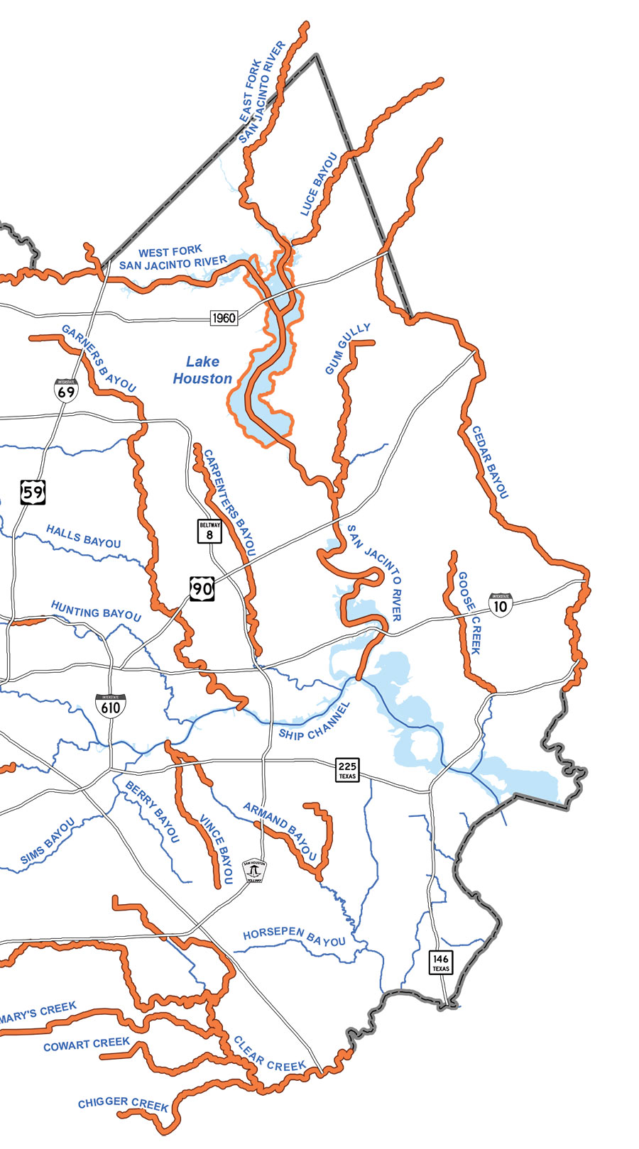
The final page of the Harris County Flood Control District’s final report on Hurricane Harvey includes the map above, with orange indicating where bayous, rivers, creeks, and gullies set new high water marks between August 25 and 29. Aside from Sims Bayou and a handful of smaller waterways, every other liquid landmark in the county outdid itself along some portion during the storm. Several — such as Cypress Creek and Carpenters Bayou (shown in detail above) — set new flood records along their entire lengths.
Less distinguished are White Oak and Little White Oak bayous, which broke records along only tiny stretches near Buffalo Bayou:


