04/21/16 4:45pm

Potential Flood Map, Bear Creek, Houston, 77084

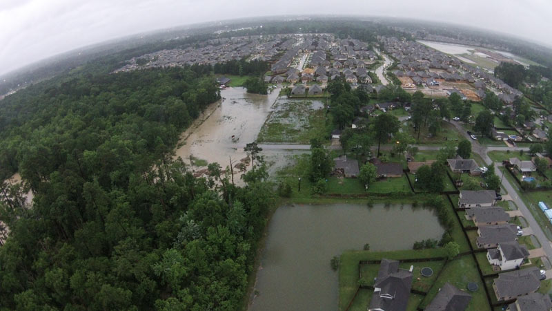
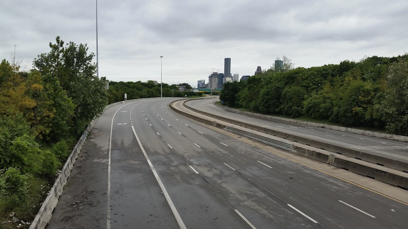
The Army Corps of Engineers will begin releasing water from the Addicks and Barker dams later this evening; nonetheless, water levels in the reservoirs are still expected to rise high enough to cause street flooding in the Bear Creek subdivision north of Clay Rd. The Corps also notes that nearby residential areas should anticipate that wildlife inhabiting approximately 26,000 acres of forested land in the 2 reservoirs may flee the rising water and enter nearby neighborhoods. That wildlife may include the feral pigs previously targeted by Harris County Precinct 3’s trapping-and-foodbanking program; sightings of animals such as deer, coyotes, and bobcats have also been reported in the reservoirs.

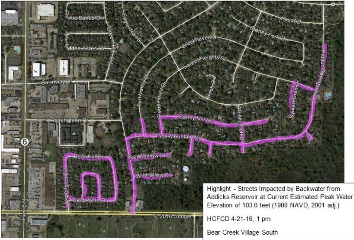
Harris County Flood Control District has published a list of streets that could be impassible for days or weeks due to flooding, as well as a few maps (one of which is shown above). Here’s the other map below, highlighting in pink the streets south of Addicks Satsuma Rd. and Langham Creek expected to get water when the level in Addicks reaches 103 feet:

CONTINUE READING THIS STORY

Creeping Into the Neighborhood
04/21/16 3:00pm

COMMENT OF THE DAY: WHO FOOTS THE BILL FOR HOUSTON FLOODS Flooding Coastal Homes“Since much of the development inside the Loop is done over existing impermeable surfaces, it would seem to me that the majority of the additional demand on our bayous is coming from the large greenfield production builders further upstream. My intuition is that the amount of building going on out there most likely dwarfs what’s occurring inside the Loop (can anyone find numbers on this?). And what’s really fueling all that development is the billions of federal, state, and local tax dollars going [toward] expanding and enlarging highway construction all over the place. By reducing the time/cost of commute, they serve as enormous incentives enabling building and selling more cheap houses further away from the employment centers closer to the city. In a nutshell, that is the sprawl Houston is famous for and I think the main source of our flooding woes. There’s no easy answer since we all want cheaper houses — but someone pays for that, somewhere.” [Build Up, commenting on Why Houston Keeps Flooding; Meet Photo Blog Purple Time Space Swamp] Illustration: Lulu

04/21/16 12:45pm

Re:Vive redevelopment at 34th and Ella, Oak Forest, Houston, 77018

1727 W 34th St, GO/OF, Houston, 77018ReVive’s plans to redo the shopping strips at the southwest corner of 34th St. and Ella Blvd. in Oak Forest look like they may keep a few existing businesses in the center, though some shuffling about may be involved. The rendering up top comes from the redeveloper’s leasing flier for the corner, which shows a makeover of several existing buildings along with plans for a few new pad sites. The flier depicts Surfhouse surf and skate shop (currently in a building next door slated for demo) snuggled into the spot recently evacuated by T-Shirt Works. The door next to that is marked with the logo for Pop & Pan (the eventual new name of Houston Panini & Provisions, pictured above in its current location facing 34th).

The siteplan included with the renderings clarifies some of the changes that might be carried out — the 2 existing buildings that form the L-shaped center rendered above are seen below on the left:

CONTINUE READING THIS STORY

Garden Oaks/Oak Forest
04/21/16 10:30am

road-closures-4-21

Replacement work on the Yale St. bridge over White Oak Bayou now won’t start until the 25th, according to an update from TxDOT. The original planned construction start drifted past in the middle of Monday’s deluge; no changes have been mentioned yet for expected 2018 reopening date.

Meanwhile, TxDOT’s Yoakum office says it’s keeping an eye on US 59 in Wharton County to the southwest of town, though that highway is not closed at the moment according to the agency’s interactive mapping system (pictured above). The map shows areas of road closures, flooding, and construction, with written descriptions for each site clarifying which lanes are affected, by what, and how badly. Zooming in further gives a clearer picture of the extent of some of the closures — below is a view of west Houston, showing the stretch of Hwy. 6 near the Addicks reservoir that could be closed for the next 4 to 6 weeks: 

CONTINUE READING THIS STORY

What’s Under Water
04/21/16 8:30am

main-street

Photo of Main Street: Russell Hancock via Swamplot Flickr Pool

Headlines
04/20/16 4:45pm

April 18th drone views over Martin Circle Dr., Porter, TX 77365

A glimpse behind some northern fencelines comes by way of drone from G.A. Eblen, who took to the Porter sky by proxy to catch these shots of planned and impromptu retention ponds in action. The Monday-morning photos center east of 59 around the Briar Tree Court subdivision — up in the right hand corner of the south-facing shot above are the well-moistened sports fields of White Oak Middle School.

Rectangles of forested land are mixed in with angular subdivisions and potential subdivisions-to-be in the suite of surveying shots.  Here’s the view north over FM 1314, toward the Family Dollar Store and Executive Inn & Suites (on the left, below):

CONTINUE READING THIS STORY

59 at 1314
04/20/16 3:45pm

Sims Metal Management Proler Southwest Scrap Recycling Facility, 90 Hirsch Rd, Galena Park, Houston, 77052

Bryan Parras snagged some after-shots of Buffalo Bayou’s up-and-down number near Tony Marron Park just east of Hirsch Rd. this week, as the rain let up on Monday afternoon and again yesterday morning. Across the channel on the north bank is the Sims Metal Management’s Proler Southwest recycling facility, whose scrap piles shown above were still soaking their toes beneath the freshly-elevated water line at the time of the Monday photos.

Below is a view of both the park’s trails and the Sims facility, looking east from the Hirsch bridge across the bayou’s confluence with somewhat-redecorated Japhet Creek from the north:

CONTINUE READING THIS STORY

Piled High in Fifth Ward
04/20/16 1:00pm

12300 North Fwy, Greenspoint, Houston, 77060

From the space between Monday’s rain and today’s, here are some late-evening snaps of the scene around Greenspoint Mall, which became a staging center for flood rescue operations before dawn on Monday morning. Following the middle-of-the-night overflow of Greens Bayou, residents from several flooded apartment complexes nearby headed to the 1970s shopping center at the social media urging of city officials and rapper Bun B; flood victims were later bussed to the Campbell Educational Center on Aldine Bender Rd. west of the Hardy tollway.

The 1.4-million-sq.-ft. mall and surrounding parking lot, just northeast of the intersection of Beltway 8 and I-45, was put up for sale by Triyar Group in February, after nearly a decade of talk about redeveloping the property with the help of the Greenspoint TIRZ.  Above is the view from the north on the I-45-facing side of the complex toward Dillard’s and Fitness Connection, currently holding a food and supplies drive and offering free showers to displaced residents. On the west side, here’s the Renaissance 15 Premier Theater, from Greenspoint Dr.:

CONTINUE READING THIS STORY

I-45 at Beltway 8
04/20/16 12:00pm

Harvest Moon Renewable Energy Company Solar Farm, FM 3013, Sealy, Texas

Today Swamplot is sponsored by Harvest Moon Renewable Energy Company, offering farm-to-market solar power for the Houston area. Thanks for supporting this website!

Do you know where your electrical power comes from? Here’s one place some of it could: Harvest Moon Renewable Energy Company’s new family-owned-and-operated 12-acre solar farm on FM 3013 in Sealy, 50 miles west of Houston — where 15,000 thin-film solar panels were installed just last year.

Harvest Moon is offering the power produced on the 1.5 MW farm to business and residential customers in CenterPoint Energy’s distribution area. It works much the way a solar-panel installation on your own building might — but without the upfront costs or cancellation fees. As with most solar installations, the panels won’t be able to meet all your power needs (there’s that whole nighttime thing when the sun isn’t available, for example). So Harvest Moon has teamed up with MP2 Energy to offer the power as part of retail plans that combine the locally produced solar energy with market-rate energy from the grid, offered at cost. Two different plans are available.

If you’d like to learn more about Harvest Moon’s Sealy facility, or its retail plans, check out the Harvest Moon Renewable Energy Company website. By signing up, you can help support the development of more solar farms in the local community. If you’re even more interested in what this company has been able to achieve so far, or just want to see for yourself how the panels track the sun all day, contact the company to find out how to visit.

Looking for the kind of sponsorship that can bring new power to your business’s marketing plan? Check out what it takes to become a Swamplot Sponsor of the Day.

Sponsor of the Day
04/20/16 11:30am

COMMENT OF THE DAY: HONORING THE SECRET FUNGAL AUTHOR OF THE HOUSTON SAGA toxic-mold“The toxic mold madness explains the entire history of our region. Think about it: the cannibal Karankawas on the Island of Doom, the ignominious and mysterious defeat of Antonio Lopez de Santa Anna, the mass hallucination that Buffalo Bayou was a navigable waterway on which a major port could be constructed, the race for space, the Candy Man, Mattress Mack and the subsequent mattress obsession, Robert Durst, the tree holocaust, and so on. We should name toxic mold as the official mold of the City of Houston.” [Memebag, commenting on What Floated and What Didn’t by the Halstead Apartments at N. Braeswood and 610] Illustration: Lulu

04/20/16 9:45am

A NEW FLAG FOR FLOOD CITY Armadillo rescued during 4/18 floodsWrites Cort McMurray of Monday’s flooding: “This week’s ‘historic’ rainfall (shake it off, TV weather people: if it happens once, it’s historic. If it happens every single year, it’s just rain) gave us the perfect symbol. You’ve seen it — it’s all over the Internet. Somewhere in our Xanadu on the Bayou, an intrepid Houstonian was spotted, knee-deep in rainwater and soaked to the skin, a yellow slicker hanging haphazardly on his shoulders, surrounded by flooded cars and floating debris, toting a waterlogged armadillo to safety. That’s it. That’s our new flag. Because wherever you live in this far-flung metropolis, you know what it feels like to be soaked to the skin and up to your knees in rainwater, carrying a stranded armadillo to safety. We’ve all been there, haven’t we? It’s the closest thing we have to a universally Houston experience.” [Houston Chronicle] Photo of armadillo rescued from Greens Bayou: Doug Miller

04/20/16 8:30am

i-45

Photo of I-45: Marc Longoria via Swamplot Flickr Pool

Headlines