Articles by

Christine Gerbode

04/21/16 10:30am

road-closures-4-21

Replacement work on the Yale St. bridge over White Oak Bayou now won’t start until the 25th, according to an update from TxDOT. The original planned construction start drifted past in the middle of Monday’s deluge; no changes have been mentioned yet for expected 2018 reopening date.

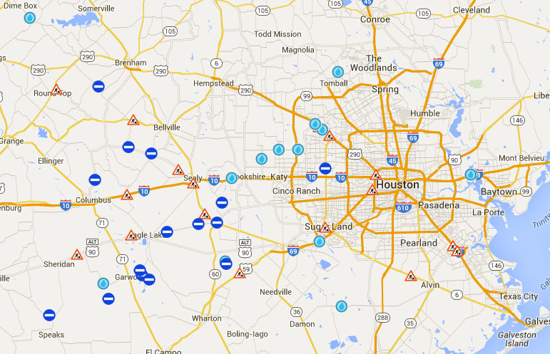
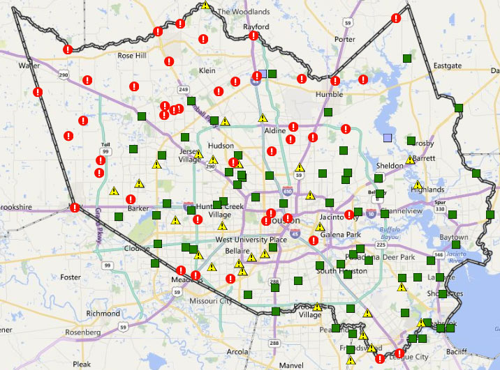
Meanwhile, TxDOT’s Yoakum office says it’s keeping an eye on US 59 in Wharton County to the southwest of town, though that highway is not closed at the moment according to the agency’s interactive mapping system (pictured above). The map shows areas of road closures, flooding, and construction, with written descriptions for each site clarifying which lanes are affected, by what, and how badly. Zooming in further gives a clearer picture of the extent of some of the closures — below is a view of west Houston, showing the stretch of Hwy. 6 near the Addicks reservoir that could be closed for the next 4 to 6 weeks: 

CONTINUE READING THIS STORY

What’s Under Water
04/20/16 4:45pm

April 18th drone views over Martin Circle Dr., Porter, TX 77365

A glimpse behind some northern fencelines comes by way of drone from G.A. Eblen, who took to the Porter sky by proxy to catch these shots of planned and impromptu retention ponds in action. The Monday-morning photos center east of 59 around the Briar Tree Court subdivision — up in the right hand corner of the south-facing shot above are the well-moistened sports fields of White Oak Middle School.

Rectangles of forested land are mixed in with angular subdivisions and potential subdivisions-to-be in the suite of surveying shots.  Here’s the view north over FM 1314, toward the Family Dollar Store and Executive Inn & Suites (on the left, below):

CONTINUE READING THIS STORY

59 at 1314
04/20/16 3:45pm

Sims Metal Management Proler Southwest Scrap Recycling Facility, 90 Hirsch Rd, Galena Park, Houston, 77052

Bryan Parras snagged some after-shots of Buffalo Bayou’s up-and-down number near Tony Marron Park just east of Hirsch Rd. this week, as the rain let up on Monday afternoon and again yesterday morning. Across the channel on the north bank is the Sims Metal Management’s Proler Southwest recycling facility, whose scrap piles shown above were still soaking their toes beneath the freshly-elevated water line at the time of the Monday photos.

Below is a view of both the park’s trails and the Sims facility, looking east from the Hirsch bridge across the bayou’s confluence with somewhat-redecorated Japhet Creek from the north:

CONTINUE READING THIS STORY

Piled High in Fifth Ward
04/20/16 1:00pm

12300 North Fwy, Greenspoint, Houston, 77060

From the space between Monday’s rain and today’s, here are some late-evening snaps of the scene around Greenspoint Mall, which became a staging center for flood rescue operations before dawn on Monday morning. Following the middle-of-the-night overflow of Greens Bayou, residents from several flooded apartment complexes nearby headed to the 1970s shopping center at the social media urging of city officials and rapper Bun B; flood victims were later bussed to the Campbell Educational Center on Aldine Bender Rd. west of the Hardy tollway.

The 1.4-million-sq.-ft. mall and surrounding parking lot, just northeast of the intersection of Beltway 8 and I-45, was put up for sale by Triyar Group in February, after nearly a decade of talk about redeveloping the property with the help of the Greenspoint TIRZ.  Above is the view from the north on the I-45-facing side of the complex toward Dillard’s and Fitness Connection, currently holding a food and supplies drive and offering free showers to displaced residents. On the west side, here’s the Renaissance 15 Premier Theater, from Greenspoint Dr.:

CONTINUE READING THIS STORY

I-45 at Beltway 8
04/20/16 11:30am

COMMENT OF THE DAY: HONORING THE SECRET FUNGAL AUTHOR OF THE HOUSTON SAGA toxic-mold“The toxic mold madness explains the entire history of our region. Think about it: the cannibal Karankawas on the Island of Doom, the ignominious and mysterious defeat of Antonio Lopez de Santa Anna, the mass hallucination that Buffalo Bayou was a navigable waterway on which a major port could be constructed, the race for space, the Candy Man, Mattress Mack and the subsequent mattress obsession, Robert Durst, the tree holocaust, and so on. We should name toxic mold as the official mold of the City of Houston.” [Memebag, commenting on What Floated and What Didn’t by the Halstead Apartments at N. Braeswood and 610] Illustration: Lulu

04/20/16 9:45am

A NEW FLAG FOR FLOOD CITY Armadillo rescued during 4/18 floods
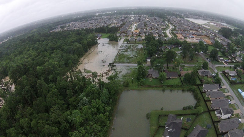
Writes Cort McMurray of Monday’s flooding: “
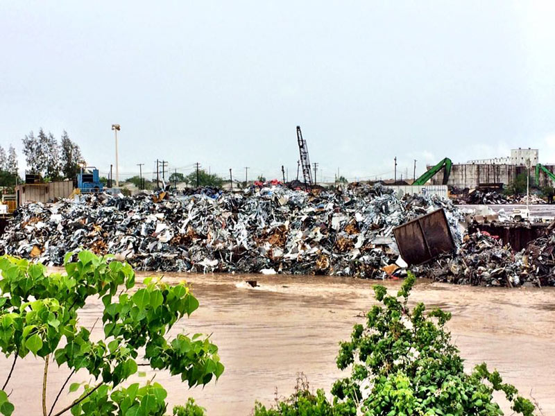
This week’s ‘historic’ rainfall (shake it off, TV weather people: if it happens once, it’s historic. If it happens every single year, it’s just rain) gave us the perfect symbol. You’ve seen it — it’s all over the Internet. Somewhere in our Xanadu on the Bayou, an intrepid Houstonian was spotted, knee-deep in rainwater and soaked to the skin, a yellow slicker hanging haphazardly on his shoulders, surrounded by flooded cars and floating debris, toting a waterlogged armadillo to safety. That’s it. That’s our new flag. Because wherever you live in this far-flung metropolis, you know what it feels like to be soaked to the skin and up to your knees in rainwater, carrying a stranded armadillo to safety. We’ve all been there, haven’t we? It’s the closest thing we have to a universally Houston experience.” [Houston Chronicle] Photo of armadillo rescued from Greens Bayou: Doug Miller

04/19/16 1:30pm

A few folks at the Halstead apartments surveyed the scene along Brays Bayou late yesterday morning, catching sight of all kinds of action in the water. The video above captures the part of the lonely journey of an unmoored porta-potty floating away from the site of the under-construction Starbucks on the former gas station corner next door; the trip was also also tracked from further upstairs in the complex, where another photographer was documenting the flood:

CONTINUE READING THIS STORY

What’s In The Water?
04/19/16 11:00am

A scattering of drones took to the air across Houston yesterday as the rain slowed to do some sight-seeing around the brand new 9-county disaster zone declared by governor Abbott in the afternoon. Filling up during floods is standard operating procedure for Buffalo Bayou Park, as demonstrated prior to the park’s first planned official opening last spring. That’s not part of the sanctioned protocol for all of Houston’s bayou corridors, but it’s hard to argue about it in the moment —above is the overhead view of Brays Bayou venturing out into broader Meyerland.

More footage comes from northwest Houston, circling around White Oak Bayou at N. Houston Rosslyn Rd. in Inwood Forest —  west and downstream of some the areas that got the most rainfall:

CONTINUE READING THIS STORY

Drones Around Town
04/18/16 5:15pm

CITY WATCHING ADDICKS AND BARKER DO THEIR OWN DAM THING addicks-april-18
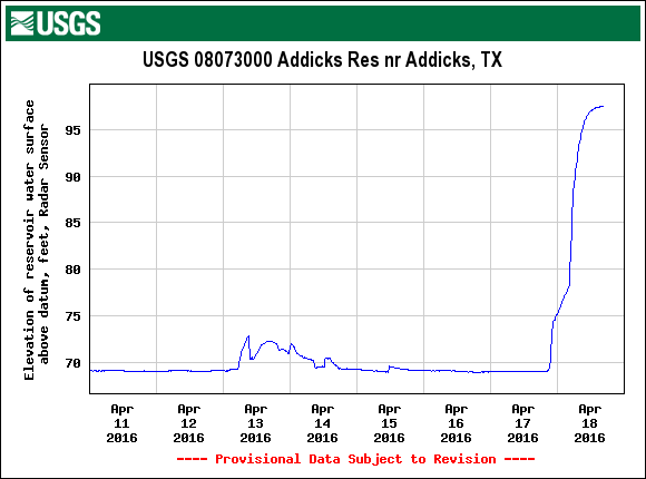
The US Geologic Survey’s tracking of water collecting at the Addicks reservoir this week shows water levels jumping about 28 feet since yesterday morning, in the preliminary data graphed above. Both Addicks and Barker reservoirs, which function in large part as parkland when not busy storing potentially billion of gallons of floodwater, feed out into Buffalo Bayou near Hwy. 6 at Westheimer Dr. through dam outlets listed as extremely high risk structures by the USACE. The city’s Twitter account noted this morning that the Addicks dam was under municipal scrutiny; the Office of Emergency Management tweeted this afternoon that the stretch of Hwy. 6 and N. Eldrige Pkwy. running through the Addicks reservoir may be closed for a few days while the area drains. [USGS; previously on Swamplot] Graph of Addicks Reservoir water surface elevation since April 11: USGS

04/18/16 2:45pm

Harris County FWS channel map, April 18, 2016

The many exclamation points scattered across the map of Harris County above mark spots where stream channels are currently overtopping their banks (in red!) or potentially thinking about it (in yellow!). The capture comes from the Harris County flood warning system interactive map, which automatically updates data from its county-wide network of rain and flood gauges every 5 minutes. Most of the current overtopped locations are concentrated toward the northwest areas of the county, parts of which got more than 17 inches of rain since Sunday morning. The green shapes mark channel gauges that aren’t currently at spillover stage or close to it (whether or not any spillover occurred earlier today).

The county’s online map also shows cumulative rainfall across the area — here’s what the totals look like across town for the last 24 hours:

CONTINUE READING THIS STORY

On and Off the Rise
04/18/16 1:00pm

1031 Stude St, Woodland Heights, Houston, 77007

While all bus and rail service is currently on hold due to widespread flooding, the route 66 bus stop sign on White Oak Dr. is still bravely performing its signaling duties (lower left above) as water from White Oak Bayou rushes past. A reader sends several studies of the area around Stude Park at the Taylor St. bridge at the southern edge of the Woodland Heights area; here’s a few more shots of the White Oak Bayou greenways gone brown this morning, with I-10 in the background to the south:

CONTINUE READING THIS STORY

Woodland Heights
04/18/16 12:30pm

Flooding along S. Braeswood Dr., Meyerland, Houston, 77096

Here’s this morning’s view north across S. Braeswood Dr. between Chimney Rock and Hillcroft in Meyerland, where Brays Bayou has once again been feeling out some alternate route options. That’s the Congregation Beth Israel synagogue and the closed-for-the-day Shlenker School across the water on the northern bank, looking higher but not that much drier; current reaadings for the nearest upstream county gauge show nearly 8 inches of rain over the last 12 hours, with higher totals further west. That hasn’t stopped some folks from checking things out from close-up:

CONTINUE READING THIS STORY

Soaking In the Scene