DIGGING UP THE LATEST ADDICKS AND BARKER RESERVOIR DIRT  The Army Corps of Engineers is exploring the possibility of deepening the Addicks and Barker reservoirs in order to increase their floodwater capacities. The Chronicle’s Mihir Zaveri digs up a request the Corps posted online quietly in January for specifics on how to remove soil from the reservoirs. The notice says the Corps is “evaluating the level of interest” from contractors, government agencies, and others “to allow for the beneficial use of material by interested parties while increasing capacity of the Government project.” Respondents are asked how much how much soil they would remove from the reservoirs, what methods they’d use to collect and transport it, where they’d deposit it, and how long the work would take. The deadline for responding to the agency was last Thursday. [Houston Chronicle; posting] Photo of American Shooting Centers and Millie Bush Dog Park off Westheimer Pkwy. in Barker Reservoir, flooded after Memorial Day, 2015: U.S. Army Corps of Engineers [license]
Sign up for the Newsletter
Tag: Barker Reservoir

THE ARMY CORPS SAW ALL YOUR ADDICKS AND BARKER LAWSUITS COMING — 23 YEARS AGO  A 1995 Army Corps of Engineers memo obtained by the Chronicle shows that the agency considered the possibility that dozens of lawsuits could be filed against it by flooded homeowners both upstream and downstream from the Addicks and Barker dams. “Given the nature of the expensive homes that would be flooded and the quality of legal representation these owners could afford, there is always the possibility of an adverse ruling,” but the likelihood of such an outcome would be low, it concluded. Those downstream from the reservoirs would have a weak case, the memo argued, because their home values benefit from the dams in the first place. And those upstream — inside the Addicks and Barker flood pools — would have to prove that flooding wasn’t just sporadic, but “frequent and inevitably recurring to amount to a taking of interest in property.” Regardless, says the document, “it would be prudent for Harris County to make sure owners, future developers, and future buyers are put on notice that they are in a reservoir.” That didn’t happen. [Houston Chronicle; memo] Photo of Barker Reservoir Near Addicks Clodine Rd. after Harvey: Kyle Steck

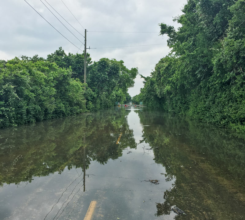
THE KATY ELEMENTARY SCHOOL WITH A FLOOD POOL SECRET  Some documents related to the Katy ISD’s 1998 purchase of the 15-acre site now occupied by Creech Elementary School at 4242 S. Mason Rd. have been frozen — in an attempt to preserve them, after they got flooded when Barker Reservoir got backed up after Hurricane Harvey. What those records might show, once thawed: some explanation for why school officials at the time signed a notice indicating they did not review a map filed with the county by Westbrook Cinco East LP (the developer from whom the property was purchased) that disclosed in a note that the land came with the risk of “extended controlled inundation.” Though several Katy schools sit on land near or in the Barker reservoir flood pool — the area expected to fill up with water when the dam is closed for a major flooding event — only Creech suffered major damage. All 800 Creech students are now attending classes at the University of Houston’s nearby Cinco Ranch campus while the school undergoes an estimated $5 million worth of repairs. The school district’s superintendent tells the Chronicle‘s Lise Olsen that he and other school officials were unaware that the school was built in the flood pool until they were contacted for her story. [Houston Chronicle] Photo of flooding at Creech Elementary School, 4242 S. Mason Rd., Katy: Breta Gatlin


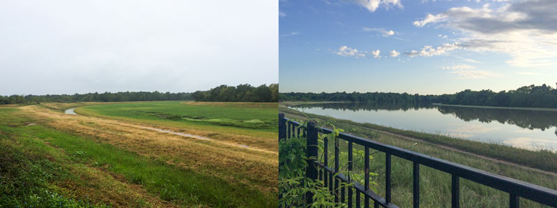
Venturing into the upper reaches of the now officially empty Barker Reservoir near Addicks Clodine Rd. and south of the Audi West Houston dealership on I-10, reader Kyle Steck finds a mostly dry landscape. (The pictured lakes in the images are features shown in maps of the area.)
“In a few weeks it will turn from brown dead apocalypse to green wonderland,” he predicts.
After the Watering

ADDICKS AND BARKER RESERVOIRS ARE NOW COMPLETELY EMPTY AND READY FOR THE NEXT FLOOD All water stuck behind the Addicks and Barker dams has now been released, the Army Corps of Engineers announced late yesterday. That means that for the first time since Hurricane Harvey-triggered rains began filling the 24,520-acre reservoirs, they are now dry and available for use again as parkland. The last bits of water actually left the Addicks and Barker reservoirs last Thursday, October 12th, and Friday the 13th respectively; the announcement was delayed, a public-affairs officer tells reporter Amelia Brust, in order to “receive legal guidance.” The Corps, writes Brust, “is now a defendant in multiple lawsuits brought by surrounding property owners who say their homes and businesses were flooded as a result of the dams’ releases.” [Community Impact] Photo of American Shooting Centers and Millie Bush Dog Park off Westheimer Pkwy. in Barker Reservoir, flooded after Memorial Day, 2015: U.S. Army Corps of Engineers [license]

Here’s a commandeerable after-and-before flooding shot, taken from a drone hovering 300 ft. above Hwy. 6 just north of the Barker Reservoir spillway. Move the slider at the bottom of the image to toggle slowly between the 2 views, taken Thursday, August 24th (on the right, not long before the arrival of Hurricane Harvey) and Tuesday, August 29th (on the left, after stormwater filled the reservoir and the flooded the area). You can also rotate and zoom the image with your pointing device or finger.
In the initial view, the camera is facing straight down Addicks-Howell Rd.; the wider Hwy. 6 appears to veer off to the left. Addicks-Howell marks the entrance to Fleetwood, the adjacent neighborhood. Rotate the view 180 degrees to see the spillway.
Houston visualization firm Reality Imaging & Mapping Technologies took the panoramic images and stitched them together to create the immersive and zoomable view, which can also be experienced as a VR image. Click here to view the image in its own browser window.
Image: Reality Imaging & Mapping Technologies
Harvey Media

COMMENT OF THE DAY: THE MORE WEST HOUSTON FLOODS, THE MORE IT STAYS THE SAME  “Why does it matter? Even after the flood, I am okay with them building there on private land. Flood risk is just one of a million things that you should look at when buying a home. Heck, even knowing what we know now, I might still buy there in the right situation. If I was looking to buy a home in that general area, and the only way I can get one is to build one on the far back end of the reservoir, I would still do it today. Even after we calibrate the models to include the recent rainfall events, we will still find that this is an outlier.” [Rex, commenting on How It Came To Pass That Hundreds of Families Purchased Homes Inside Houston’s Reservoirs; previously on Swamplot] Map of subdivisions in or along the edge of the Addicks and Barker reservoirs: ProPublica

HOW IT CAME TO PASS THAT HUNDREDS OF FAMILIES PURCHASED HOMES INSIDE HOUSTON’S RESERVOIRS  Many of the flooding victims upstream of Addicks and Barker dams learned for the first time that their homes were inside government-designated reservoirs only after rains from Harvey flooded their neighborhoods, reports Naomi Martin. How had they come to live there? “The corps didn’t feel the need to acquire all the land at the time the reservoirs were built, [the Army Corps of Engineers’ Richard] Long said, because that land was nothing but rice farms and fields where cattle grazed. It didn’t stay that way. In 1997, developers came before Fort Bend County government for approval to put subdivisions on the pastures. Aware of the flood risk to the area, the county was in a bind. It didn’t have the authority to prohibit development or establish zoning rules, said County Judge Robert Hebert, who has been in office since 2003. So the county insisted, ‘over great objection’ by developers, on including a warning on the plat, Hebert said. The county, he said, ‘felt it was a defect on the land that should be pointed out.'” The warning appeared as a small note on the plat document establishing some later Fort Bend County subdivisions, but equivalent declarations were absent on documents establishing nearby Harris County subdivisions. [Dallas Morning News] Aerial view of flooding in Canyon Gate, Cinco Ranch: Michael Fry

COMMENT OF THE DAY: COULD WE BORROW BRAYS BAYOU RIGHT AFTER YOUR NEXT FLOOD, PLEASE?  “. . . An undergound aqueduct probably won’t resolve the situation. However, this storm has made it pretty clear that having both Barker AND Addicks draining 100 percent into Buffalo Bayou may not be ideal. An addition channel that would allow USACE to divert some of the Barker outflow to Brays Bayou would allow for some flexibility.
While Brays DID flood during Harvey, the water receded very quickly, with the water back within its banks and falling quickly while Buffalo Bayou was still rising.” [Angostura, commenting on Clearing Out the Mold; Houston’s Drinking Water Close Call; The Floodeds and the Flooded-Nots] Photo of construction at Addicks and Barker Dams: U.S. Army Corps of Engineers [license]
“. . . An undergound aqueduct probably won’t resolve the situation. However, this storm has made it pretty clear that having both Barker AND Addicks draining 100 percent into Buffalo Bayou may not be ideal. An addition channel that would allow USACE to divert some of the Barker outflow to Brays Bayou would allow for some flexibility.
While Brays DID flood during Harvey, the water receded very quickly, with the water back within its banks and falling quickly while Buffalo Bayou was still rising.” [Angostura, commenting on Clearing Out the Mold; Houston’s Drinking Water Close Call; The Floodeds and the Flooded-Nots] Photo of construction at Addicks and Barker Dams: U.S. Army Corps of Engineers [license]

STUFF YOU PROBABLY SHOULD KNOW ABOUT THE ADDICKS AND BARKER RESERVOIRS  Lived in Houston for years but still coming up to speed on how the Addicks and Barker dams are supposed to work — just as the reservoirs reach to their highest-ever levels? This brief explainer from Kiah Collier and Neena Satija of The Texas Tribune Al Shaw and Lisa Song of ProPublica should overfill you with info: “As of now, the Army Corps says there’s enough excess water in the reservoirs that some of it will flow around (not overtop) these auxiliary spillways. . . . The Army Corps can’t say exactly what areas might experience additional flooding, but local officials listed 53 subdivisions in the Addicks watershed and 40 in the Barker watershed (shown in brown in the map above) at high risk of flooding. Jeremy Justice, a hydrologic analyst at the Harris County Flood Control District, said two subdivisions near the Addicks reservoir—Twin Lakes and Lakes On Eldridge—are particularly vulnerable to flooding from the Addicks spillway. Those homes ‘probably should never have been put there,‘ he said.” Thousands of homes around the reservoirs have now flooded — some because they’re close to rising bayous, and some because of bad neighborhood drainage, they write. “But many are flooding because they are in an area that the Army Corps actually considers to be inside the reservoirs. (See map.)” [Texas Tribune; ProPublica version with links; previously on Swamplot] Map: ProPublica

The map above outlines the actual locations of neighborhoods designated by officials yesterday as being at risk from flooding over the back sides of Houston’s dual Buffalo Bayou reservoirs — in advance of actual spillovers, which began last night and continued this morning. The map was put together by Chronicle data reporter John D. Harden, using information from the Harris County Flood Control District. Zoom in and you can identify specific streets and neighborhoods on the upstream side of Addicks (in red) and Barker (in blue) reservoirs.
Names of the affected neighborhoods are listed on the map’s fly-out panel, available by clicking on the icon at the top left corner of the map. Click on the icon at the top right corner to enlarge the map if you need to.
To lessen the risk of flooding to these areas, officials have been releasing water out the other end, through the Addicks and Barker dams into Buffalo Bayou — possibly (depending on bayou water levels) endangering neighborhoods and structures downstream.
- A weary Houston likely to endure catastrophic flooding through Wednesday [Houston Chronicle]
- Officials fear rising rivers, failing levees [Houston Chronicle]
Map: Houston Chronicle

A reader caught the view above during a lunchtime bike ride into the Barker reservoir yesterday. The shot shows the nearly submerged stop signs on the currently-closed road barricade where Barker Clodine Rd. merges into the hike-and-bike trail system running throughout much of the reservoir (which stretches between I-10 and the Westpark Tollway just west of Hwy. 6). The Corps of Engineers has been releasing water from both Barker dam and its sister reservoir Addicks across I-10 since Thursday — but the level behind the dams continued to rise for a few days as additional water drained into the basins from the surrounding watersheds, faster than that water could be safely released downstream into Buffalo Bayou.
Both Barker and Addicks reservoirs’ levels finally began dropping on Saturday — though both started filling again briefly on Sunday as water from later-in-the-week storms trickled east from the surrounding watersheds. Below is an up-to-date look at Barker reservoir’s change in storage since the Tax Day flood, per USGS measurements:
Addicks and Barker

A water-watching reader sends some south-facing photos from yesterday evening (right) and last October, comparing views over the fenceline of the 400-ft.-wide diversion channel at the northern edge of the Addicks reservoir. The channel picks up most of the flow from Langham and Horsepen creeks where they join up as they flow south into Addicks. The 400-ft.-wide floodway was dug in the 1980s; the flow usually lurks down in the narrow channel seen in the shot on the left.
The scene above is less than a mile east of Bear Creek Village, where water is now moseying into neighborhoods from the western edge of the reservoir (and washing some wildife and livestock around). The Army Corps of Engineers has been releasing water from both Addicks and Barker dams to minimize the pooling (and relieve stress on the dam structures themselves) — but those releases have to be done slowly enough to avoid causing additional flooding downstream along Buffalo Bayou. Meanwhile, water is still flowing into the reservoirs from western watersheds; the measured levels behind the 2 dams topped all previous water level records and normally allowed pooling limits in the reservoir by Tuesday, and has been rising since. Here’s a shot of water gushing out through some of the gates of the Barker dam this afternoon:
Drinking It In, Spitting It Out
