- 13215 Binnacle Way [HAR]
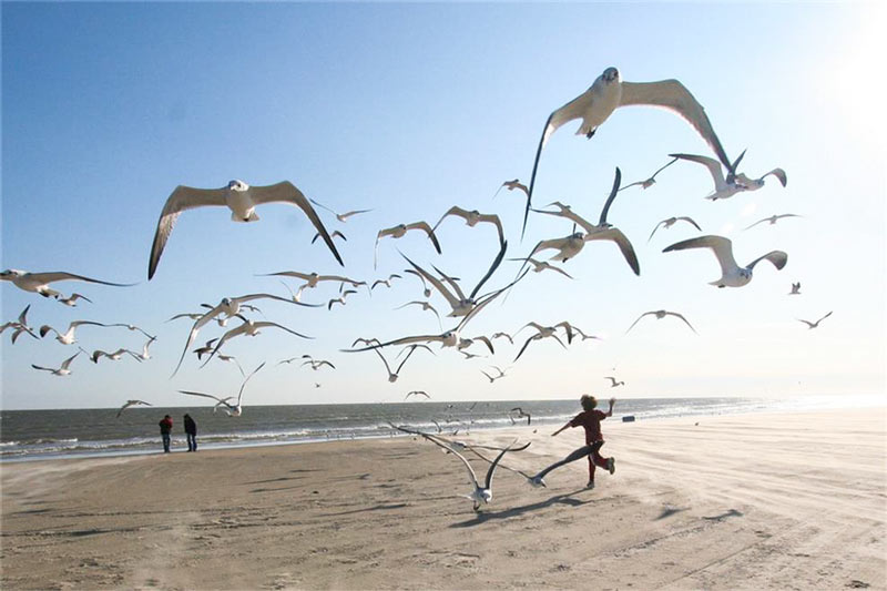
EXCESSIVE GALVESTON BEACH BACTERIA PROBABLY NOT LEG-THREATENING, JUST FECAL, SAY OFFICIALS 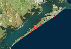 Scott Packard assures KHOU this week that the beach advisories put out by the Galveston County Health District lately aren’t related to flesh-eating strains of Vibrio bacteria — the agency has been fielding concerned phone calls in the wake of a Jacinto City man’s ongoing hospitalization and forced amputation due to a suspected Vibrio infection following a swim in Galveston with an open wound. But direct infection from seawater contact, while a perennial occurrence in Gulf Coast states, is nonetheless extraordinarily rare, Packard says. Rather, the beach advisories reflect above-standard measuremens of run-of-the-mill fecal bacteria: “Typically after periods of heavy rains [in] any recreational or coastal area, rain water will wash cattle waste, pet waste and some sewage overflows into the Gulf through rivers and streams, and that will make the levels spike for typically a day or so.” [KHOU; previously on Swamplot] Galveston Island sites with high bacteria levels: Texas General Land Office

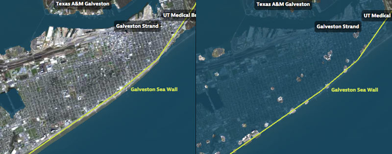
That’s Galveston Island going for a dip in the before-and-after captures above, from a set of interactive timelapse maps released by the Texas Tribune and ProPublica yesterday (along with several articles by authors Kiah Collier and Neena Satija). The new maps model flooding across the Houston region during Hurricane Ike — as well as what would have happened if Ike had actually hit just south of Houston, as meteorologists initially expected.
The maps are your chance to relive an old disaster, or to see how many of your neighbors you can take out with a hypothetical-but-not-unrealistic future storm: users can pick between Ike, south-er Ike, a storm 15% stronger than Ike (nicknamed Mighty Ike), and a modeled 500-year storm (which the article suggests may actually be a concern on the every-few-decades-or-so level; ‘500-year’ has always meant ‘a low probability in any year’, and climate change is shaking up old modeling assumptions). The graphics also include a few dramatic face-offs:Â Mighty Ike and the 500-year storm VS. 2 of the miles-long multi-billion-dollar coastal protection projects being studied for the upper Texas coast.
You can even search for your home address in the map system to see what flood levels might look like in your own back yard. Here’s what the maps show happening to the Clear Lake, Seabrook, and League City areas at the peak of the 500-year storm model’s storm surge, which the article says is a “not if, but when” event:
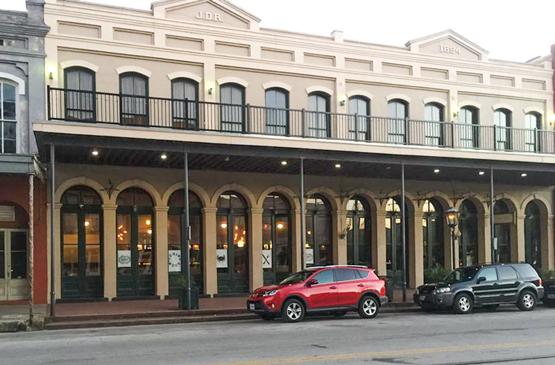
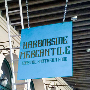 Down in Galveston, seafood-slash-southern-focused Harborside Mercantile is opening up for a preview this evening, after clearing some liquor licensing hurdles that set back the planned December startup. The restaurant, located at 2021 Strand St., is a collaboration between Richard Craig (whose 3-wheeled Hubcap Grill will be getting a 4th location inside IAH) and Joshua Martinez (owner of The Modular foodtruck and the former Chicken Ranch).
The Strand, buoyantly styled as the “Wall Street of the South” in the 19th century, was battered by fires, the Civil War, and numerous destructive hurricanes before sinking out of prominence and settling into life as a warehouse district; historical restorations in the 1960s paved the way for the district’s eventual resurgence as a tourist destination.
Photos: Harborside Mercantile

A SEAWALL IN CANADA TAKES A DIFFERENT APPROACH TO COMBATING COASTAL EROSION Meanwhile, in Vancouver: Those familiar with Galveston’s frequent sand replenishment projects likely know that flat seawalls can exacerbate beach erosion by reflecting wave energy that would dissipate more readily in a natural sandy setting. In response so-called king tides pummeling the coast of Vancouver, a Canadian landscape artist collaborated with a biologist and engineers to address beach erosion in a new way. Blending principles of ecology, hydrology, and aesthetics, Metamorphous incorporates boulders, plant life, and an angular a steel structure intended to rust away altogether in less than 100 years. The functional public art piece slows the flow of water as it rushes inland, causing sand to be deposited on the beach for the first time in resident memory. [Citylab]
COMMENT OF THE DAY: WHAT ENDING FEDERAL FLOOD INSURANCE SUBSIDIES COULD DO FOR GALVESTON  “Biggert-Watters would have destroyed the home market in many of Galveston’s West End beach communities. My wife and I were looking at homes just as the revised rate plan went into effect in late 2013. The quote I received for JUST FLOOD INSURANCE on a $250K house was $40,000 per year. As long as the government allows federally backed mortgages in these areas, they will have to subsidize the insurance rates. It really is that simple. If the rates aren’t subsidized, the market will collapse for these homes. It will be a vicious circle. Those that need a mortgage to afford a home won’t be able to afford insurance. Those who own a home with a mortgage won’t be able to afford insurance. Homes will only be marketable to cash buyers who can self-insure. How much would you pay for a home that you could only market via an owner-financed or cash transaction? A property that would essentially be unmarketable to buyers via traditional mortgage.” [Mike Honcho, commenting on Comment of the Day: Why You Can Get Flood Insurance in Houston] Illustration: Lulu

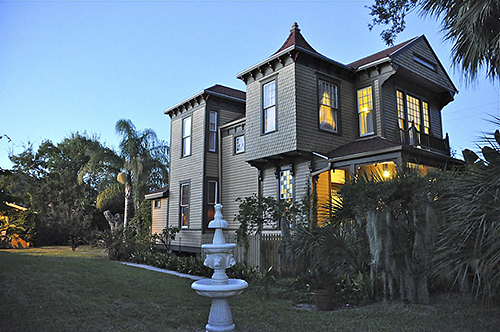
More Gorey than gory in its trimmings, a Queen Anne Galveston home — sporting a slight witch’s hat steeple atop a shingle-sided upper room — popped up on the market just before Halloween. It’s a double-lot property located on a corner 7 blocks from the beach on the East End of the island city. Was it around for the Great Storm of 1900?


Sure it’s dug 35 ft. into the earth now, but who’s to say sometime after an additional 3 decades or so of mulling it over we couldn’t insert a steel hull under the thing — so that when the waters of the rising Gulf came for Houston, the Astrodome, stuffed with valuables and maybe a species specimen or two, couldn’t just up and spirit itself away? Of course in this scenario the whole Reliant Park area has already reverted to swamp, and raised-seawall Galveston’s been entirely underwater for a number of spring break cycles. It’s 2050, and after an extra water surge from Hurricane Rick — Rick? — overcomes the submerged island’s new dike, Houston has just a little bit of time left to get the Dome up on moorings, so the gently but steadily rising waters can lift it and carry it off to sea.
“One of the best things about this proposal,” writes the distinguished Reliant Stadium-loathing jury, not missing a beat, “is that it gets the dome away from its neighbor.” And so: second prize for “The Houston Ark,” by San Antonio architects Brantley Hightower (of HiWorks) and Erica Goranson (of Lake Flato Architects), in the strangely timed whatever-shall-become-of-the-Astrodome design competition sponsored by The Architect’s Newspaper and the zippy folks at YKK AP, whose winners were announced earlier this month.
What would this cargo-laden Astrodome carry?


