COMMENT OF THE DAY: THE MORE HOUSTON CHANGES, THE MORE IT STAYS THE SAME  “The problem is that Houston is in a constant state of flux. The Houston you know at 20 is unrecognizable at 50, no matter what year you were born. There is no classically recognizable Houston or Houstonian — the only thing most Houstonians share as a character trait is a mutual lack of interest in the past. When I wrote a novella about Houston, I made it ground zero of a global amnesia plague. Seemed appropriate.” [AMP, commenting on Novel Approaches to Houston] Illustration: Lulu
Sign up for the Newsletter
Tag: Development Patterns

COMMENT OF THE DAY: START SAVING WATER EARLY FOR LOWER FLOODING RETURNS  “Like I said before, the real solution is engineering and good land cover practices upstream. By the time the flow gets to [the Bay], there is no real answer. Just like your child and your 401k, the earlier in the life cycle you contribute, the more impactful that contribution will be further down.” [Rex, commenting on Comment of the Day: All Houston Floodwater Backs Up in the Same Drain] Illustration: Lulu

CROSS-COUNTY ACCOUNTING FOR THE HOUSTON FLOODING PUZZLE 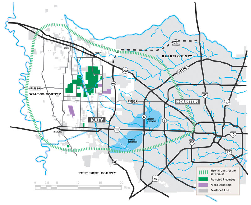 Kim McGuire checks in on the local hardscape in Friday’s Chronicle, as part the latest piece in a series examining roots of the area’s chronic flooding habit. The Houston Area Research Council tells McGuire that roughly 337,000 out of 1.1 million acres of Harris county were covered by surfaces impervious to rainfall runoff as of 2011 (the most recent year of data); meanwhile, softer surrounding counties (including the ones hosting much of the much-reduced Katy Prairie) have been racing to catch up with much higher rates of added hard area. McGuire notes that while developers are generally required to add detention basins to projects that increase the rate of runoff from their land, this does not actually require them to “eliminate runoff from their projects.” Mark Mooney, an engineer for Montgomery County, also tells McGuire that despite the regulatory scrutiny on any individual project with respect to keeping a balance betweeen added runoff and added detention, its still “clear [that] the way water moves through our county has changed. It’s all part of a massive puzzle everyone is trying to sort out.“ [Houston Chronicle; previously on Swamplot] Map of Houston drainage and current/historic Katy Prairie extent: Katy Prairie Conservancy

COMMENT OF THE DAY: STRAIGHTENING OUT THE CONCRETE-LINED BAYOU PARADOX 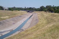 “While I am no run-off-water-channeling expert, I am under the impression that tossing out the concrete is not just for appearances. The concrete ditch moves the water faster than the natural channel, and can [thereby] actually aggravate flooding rather than cure it. Returning to the natural channel structure may mitigate flooding.” [Al, commenting on Might White Oak Bayou Ditch Its Concrete?] Photo of White Oak Bayou channel: Swamplot inbox

COMMENT OF THE DAY: WHY HOUSTON GREENSPACES CAN’T SHARE THE GREEN  “The big money is coming from private donations (Buffalo Bayou Partnership, Hermann Park Conservancy, Memorial Park Conservancy), most likely with ‘strings attached’ that require that they must be used in a specific park. I’m sure the Parks and Rec people would love to do more special projects in the neighborhood parks, but it’s also going to require someone with deep pockets to step up for them.” [slugline, commenting on The Places a 117-Ft.-Tall Yellow Corkscrew Tower Could Fit In Along Buffalo Bayou] Illustration: Lulu

COMMENT OF THE DAY: THE PROOF IS IN THE PERMITTING  “You don’t need to read a university study to know the Houston housing market is going through a downturn. You don’t even have to look at HAR. To gauge the health of the Houston real estate market, you only have to look at the Daily Demolition Report: only 2 residential permits today; only 1 yesterday. Crisis!” [Angostura, commenting on Move-In Day Approaches for New Phillips 66 HQ; Montrose’s Crowded Mexican Restaurant Scene] Illustration: Lulu

COMMENT OF THE DAY: WHY FLOOD CONTROL ENTHUSIASTS KEEP EYEING PREVIOUSLY PAVED LOTS  “This is a standard practice: to elevate [existing] commercial properties so they will drain off the property. It is very easy to do. The concern is that the city of Houston does not require new properties on old lots to detain water on the lot.  . . . Elevated commercial properties that do not mitigate acre-foot-for-acre-foot will lead to water running off and flooding adjacent properties. It is a simple concept, but developer propaganda is strong. The most common myth promulgated by the developers is that if something was already concrete then a new property need not mitigate run-off. The fact is, any time a new development is built that does not mitigate run-off, it will force water onto its neighbor. [Flooding, commenting on Former Fiesta Site Preps for Teardown as Heights Dry Zone Petitioners Circle] Illustration: Lulu

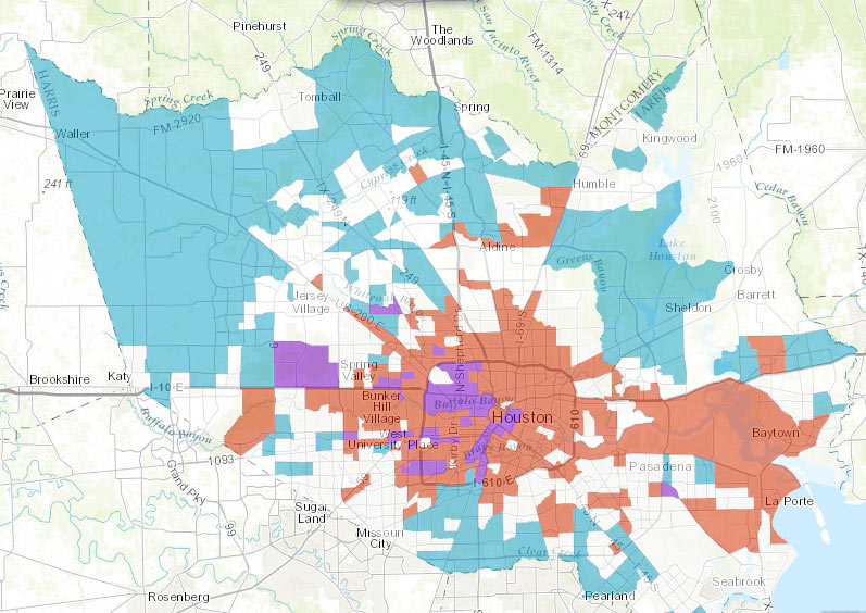
The land between the Grand Parkway and Hwy.-6-FM-1960 contained more than 37 percent of the construction sites in Harris County over the last decade, according to the Houston in Flux report and interactive maps released by the Kinder Institute for Urban Research last week. The maps above highlight regions where demolition and construction permits were issued at above-county-average rates between 2005 and 2015. Red shows areas with high demolition rates, blue shows high construction rates, and purple shows spots where both stats beat the average — areas authors Kelsey Walker and Kyle Shelton refer to as high-turnover (mostly concentrated in the Inner Loop and to the northwest).
Each subsection of the walkthrough embedded above contains a “learn more” link that provides access to (and a quick explanation of) various data types that can be displayed. A section on census-tract-level trends (including building, demo, and turnover, as shown up top) is followed by a section allowing a detailed property-by-property browsing of the data, as shown below:
Drawing It Out

COMMENT OF THE DAY: WHAT THE FORMER HEIGHTS POST OFFICE SPOT WON’T TURN INTO  “11th St. is a thoroughfare. So is Yale St. . . . There is no street parking in that area. That really nice old town feel of 20th St. (19th?) is not something you can replicate here — that is a shopping/ restaurant district with grandfathered-in diagonal parking spaces and a road wide enough to accommodate it. If you want another town-center-type development, someone will have to build it (and acquire a lot more property than this space here). Typically, those historical main streets can’t be artificially manufactured. Just appreciate the one you have and be happy they didn’t build a 500-bed apartment complex next to your house.” [Commenter7, commenting on A Peek at What’s Up Next Once the Former Heights Post Office Comes Down] Rendering of planned Heights Central Station shopping center: MFT Interests

WHERE THE HECK IS HOUSTON’S BIOTECH BOOM? 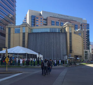 Almost $3 billion in new construction projects are underway in the Texas Medical Center, says Roxanna Asgarian in last month’s Houstonia. The district is known as the world’s largest cluster of medical practice and research facilities — but “what the TMC is not known for,” writes Asgarian, “is turning that research into new drugs and devices . . . The situation is, in many respects, baffling. All the major building blocks for a thriving biotech industry exist here, including huge clinical and research institutions, world-renowned physicians and researchers, highly skilled engineers, and a bustling business community. So what’s missing?” [Houstonia] Photo of Texas Medical Center Commons parking garage at 6550 Bertner Ave.: Texas Medical Center

COMMENT OF THE DAY: TRACING THE ROOTS OF THE HOUSTON GRID  “The Republic of Texas in 1837 created various categories of immigrants in order to assign land grants. The coastal regions and plots fronting major rivers were for the most part already claimed by settlers that had arrived under Mexican governance, so what was allocated for new settlers was primarily west and north of the coast and between rivers. Most of these grants were made in 640-acre (1-square-mile) increments (or double or half that). These were made as geometrically regular as possible given natural features. In the nearly-featureless prairies west of Houston and notably in the Katy Prairie, you had these perfect grids dominating much of the plat maps. Roads and fences were built to follow that pattern for obvious reasons. The legacy of this system has shaped policy ever since.” [TheNiche, commenting on Ring Around the Katy Prairie, and Other Orbital Highway Fun] Map of previously planned thoroughfare routes across Katy Prairie Conservancy preserve: Harris County Planning and Infrastructure Department


If you missed yesterday’s meeting in Hockley, you have until Wednesday to send Harris County your thoughts on the map above, from the official county study of road network expansion proposed between I-10 and 290 west of the Grand Pkwy. The thick red dashes mark a proposed loop road circling around almost the entirety of the Katy Prairie Conservancy‘s land preserve (shown as the darkest green blocks, amid slightly-grayer-green agricultural/undeveloped land and a few kelly-green public parks). Purple dashes show the proposed routes of new or expanded thoroughfares, some of which cut through the preserve and cross through the Cypress Creek floodway (shown as a blue underlay making a rough U through the conservancy’s land).
Further west (marked in blue dashes) is the not-yet-planned-but-still-showing-up-in-planning-maps route of Houston’s proposed outer-outer-outer loop, SH 36A (formerly nicknamed the Prairie Parkway). The map above also includes overlays of Harris County’s future development predictions, with dark taupe showing existing development and slightly lighter taupe showing expected expansion.
For comparison, here’s the Katy Prairie Conservancy’s map of west Houston; currently developed areas are marked in gray, the organization’s protected areas are marked in green, and the dashed green band shows how far the prairie ecosystem used to extend:
Up the Watershed

COMMENT OF THE DAY: WHEN NOT ZONING BECAME BOLD NEW HOUSTON TERRITORY  “. . . Nobody can deny that Houston does things differently, but it does these things in part by not doing something that every other major city does — by bucking the trend despite repeated opportunities to go along with that trend. Houston is so notable in this regard that the Wikipedia page on ‘Zoning in the United States’ has 2 sections of text about the history of zoning: ‘Origins & History’, and ‘Houston’. . . . Houston is the one and only control case that exists by which the impacts of zoning can be tested. To my mind, this qualifies as innovation. Zoning may have been innovative when it was first tried in NYC in 1916, I’ll also grant that — but it’s precisely 100 years later, and — now — Houston’s position is innovative.” [TheNiche, commenting on Houston’s Counterintuitive Optimism; San Jacinto Mall Redo] Illustration: Lulu

All the little red dots above show storefront retail locations throughout the Houston area. The map comes from Portland-based City Observatory, which just released a shiny new report on using the number and arrangement of customer-facing businesses to guide city planning. The bar in the top left corner lets you jump around between Houston and the 50 other cities mapped by the project.
Like the other studied towns, Houston is shown with a black ring marking off a 3-mile radius around Downtown. A closer look at Downtown shows a sharp divide in storefront density across the Main St. corridor:Â
CONTINUE READING THIS STORY
Marking the Market

COMMENT OF THE DAY: WHO FOOTS THE BILL FOR HOUSTON FLOODS  “Since much of the development inside the Loop is done over existing impermeable surfaces, it would seem to me that the majority of the additional demand on our bayous is coming from the large greenfield production builders further upstream. My intuition is that the amount of building going on out there most likely dwarfs what’s occurring inside the Loop (can anyone find numbers on this?). And what’s really fueling all that development is the billions of federal, state, and local tax dollars going [toward] expanding and enlarging highway construction all over the place. By reducing the time/cost of commute, they serve as enormous incentives enabling building and selling more cheap houses further away from the employment centers closer to the city. In a nutshell, that is the sprawl Houston is famous for and I think the main source of our flooding woes. There’s no easy answer since we all want cheaper houses — but someone pays for that, somewhere.” [Build Up, commenting on Why Houston Keeps Flooding; Meet Photo Blog Purple Time Space Swamp] Illustration: Lulu
