THE ESTIMATED PRICETAG ON A STOP TO HOUSTON FLOODING 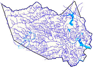 Amid the latest round of area flooding last week, Dylan Baddour traces the roots of Houston’s massive publicly funded drainage projects, which have brought the total length of Harris County waterways up to 2,500 miles (many of those channels widened, lined with concrete, or dug from scratch). Baddour also talks with current county flood control district director Mike Talbott about what it would take to expand and refine the city’s outdated flood infrastructure (which is often locked into place by close surrounding development) up to modern expectations — namely, that the flow of water over land that would otherwise be totally submerged should be totally controlled. Baddour writes that Talbot “has a simple solution: allocate $26 billion, more than a fifth of the state’s 2015 budget, mostly to buy property adjacent to the waterways, bulldoze and expand the canals.” Rice University ecologist Ron Sass tells Baddour he’s surprised the city hasn’t been tearing down old houses to build new bayou channels: “We build freeways. I would think that a bayou would be as important to our infrastructure as a freeway.” [Houston Chronicle] Map of Harris County waterways: Harris County Flood Control District
Sign up for the Newsletter
Tag: Harris County

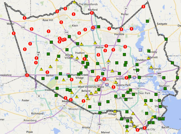
The many exclamation points scattered across the map of Harris County above mark spots where stream channels are currently overtopping their banks (in red!) or potentially thinking about it (in yellow!). The capture comes from the Harris County flood warning system interactive map, which automatically updates data from its county-wide network of rain and flood gauges every 5 minutes. Most of the current overtopped locations are concentrated toward the northwest areas of the county, parts of which got more than 17 inches of rain since Sunday morning. The green shapes mark channel gauges that aren’t currently at spillover stage or close to it (whether or not any spillover occurred earlier today).
The county’s online map also shows cumulative rainfall across the area — here’s what the totals look like across town for the last 24 hours:
On and Off the Rise

Go ahead and play around with the map above (created by activist Kris Banks), showing the precinct-by-precinct outcome across Harris County for last month’s Republican presidential primaries. Shades of red show the spots won by Cruz (most of them, though a lighter shade indicates less solid support). Precincts won by Rubio show up in shades of blue (mostly clustered on the west side of the Inner Loop), while Trump support is marked in gold (mostly northeast and south of Downtown, as well as strung out along the Westpark Tollway); a few Carson precincts show up in green.
January Advisors’s Jeff Reichmann recently took a look at Banks’s election maps, which include results from both parties’s primaries and a starkly geographically-split down-ballot race for the Democratic district attorney nomination. You can click on each precinct to get its number and a breakdown of the results. Here’s how things looked for the Democrats, with the Sanders precincts in green spangling a field of Clinton blue:
Drawing It Out

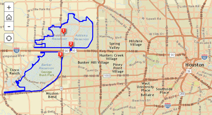
The Army Corps of Engineers is holding a public meeting amid this evening’s predicted thunderstorms to chat about the recently begun replacement work on the Addicks and Barker dams, which have each won the rare and highly distinguished label ‘extremely high risk’ through a combination of structural issues and close proximity to Houston. For those not planning to flood the Corps with questions and comments in person, there’s a somewhat-outdated online survey, as well as an online map of updates on the project’s progress. Work to replace the outlet structures of the dams began in February, and is expected to take about 4 years.Â
The 2 reservoirs, spread out across 26,000 acres on either side of the Katy Fwy. near Highway 6, starred in the Sierra Club’s 2011 lawsuit over the construction of Segment E of the Grand Parkway through the reservoirs’ catchment area. The club claimed development spurred by the road could send major additional runoff to the reservoirs, increasing the chance of dam failure, which Dave Fehling of Houston Public Media reports “could do an estimated $60 billion dollars in damage to downtown Houston, to industries along the Houston Ship Channel, [and] even to the Texas Medical Center.” The judge didn’t stop construction of Segment E, but did order new studies on its potential flooding impacts.
Addicks and Barker Reservoirs


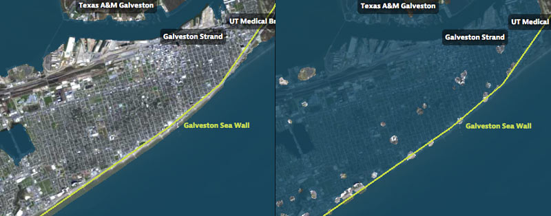
That’s Galveston Island going for a dip in the before-and-after captures above, from a set of interactive timelapse maps released by the Texas Tribune and ProPublica yesterday (along with several articles by authors Kiah Collier and Neena Satija). The new maps model flooding across the Houston region during Hurricane Ike — as well as what would have happened if Ike had actually hit just south of Houston, as meteorologists initially expected.
The maps are your chance to relive an old disaster, or to see how many of your neighbors you can take out with a hypothetical-but-not-unrealistic future storm: users can pick between Ike, south-er Ike, a storm 15% stronger than Ike (nicknamed Mighty Ike), and a modeled 500-year storm (which the article suggests may actually be a concern on the every-few-decades-or-so level; ‘500-year’ has always meant ‘a low probability in any year’, and climate change is shaking up old modeling assumptions). The graphics also include a few dramatic face-offs:Â Mighty Ike and the 500-year storm VS. 2 of the miles-long multi-billion-dollar coastal protection projects being studied for the upper Texas coast.
You can even search for your home address in the map system to see what flood levels might look like in your own back yard. Here’s what the maps show happening to the Clear Lake, Seabrook, and League City areas at the peak of the 500-year storm model’s storm surge, which the article says is a “not if, but when” event:
Hell and High Water

JUDGE EMMETT HAS AT LEAST 6 THINGS TO SAY ABOUT THE ASTRODOME 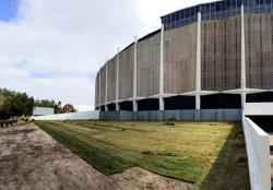 It’s time again this Groundhog Day afternoon for the County Judge’s annual State of the County address. Judge Emmett’s speech was slated to include 6 points about the State of the Astrodome (which, as Astros historian Mike Acosta notes, is now fence-free and getting some new landscaping, as pictured above). The points, as summarized by the Houston Chronicle: “1. The Dome is iconic and revered by ‘a large majority’ in the county. 2. The Dome belongs to Harris County and is fully paid for. Upkeep costs are minimal. 3. The Dome is structurally sound, but a major repurposing will cost hundreds of millions. 4. Anything done to alter the Dome must be approved by the Texas Historical Commission. 5. The Houston Livestock Show and Rodeo and the Houston Texans have contractual rights at NRG Park, and the county must keep its end of that bargain with maintenance. 6. No private interest has come up with the money to save the Dome.” The latest plans being batted around for the Dome: bring the first floor up to ground level to create parking or storage space underneath, then start talking about a public-private-retail-indoor-park space. [Houston Chronicle, previously on Swamplot] Photo: Mike Acosta

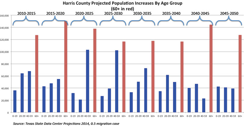
A reader tells Swamplot that he thinks recent news coverage of population projections from the state demographer up until the year 2050 have missed the big story: The dramatic projected growth of the over 60 population in Harris County. Between 2010 and 2050, it’s expected to more than triple, from around 500,000 at the turn of the decade to about 1.5 million in 35 years.
To illustrate, RobertinHeights sends in the chart above, showing how increases in the older age segment will dominate others in the coming decades. “By 2040 we will have an over 60 population in Harris County that is larger than the total current population of Dallas,” he writes. “Go long property by the Medical Center.”
- 2014 Population Projections by Migration Scenario for Texas [Texas State Data Center]
Chart: RobertinHeights
Demographic Graphics
