COMMENT OF THE DAY: BATHTIME IN COTTAGE GROVE “I took a look at the flood map which gave me the first inclination of worry. I guess hurricanes don’t give me the biggest concern since they’re not as frequent… *knock on wood* – I guess I’m just trying to get a feel for how often you might find water in your house. One of my friends lived in the Heights and would have a couple inches of water in her house everytime it rained reasonably hard and I’m just trying to avoid that situation. Once again, any insight or other experiences people have had or heard of in Cottage Grove would be great!” [Ryan, commenting on The New Inner Loop Townhome Poster Child]
Tag: Flooding
COMMENT OF THE DAY: THE SUPERMARKET STANDSTILL IN TIMBERGROVE “Outside of internal remodels, they can’t do anything with the [H-E-B] Pantry location [at T.C. Jester and 18th St.] except leave it. The Shopping center along with the one located across the bayou (old K-Mart) are located in the Floodway (not just floodplain). There isn’t much they can do [to] those [sites.] HEB would need an entirely new location.” [kjb434, commenting on Buffalo Modern: The New H-E-B in West U]
THE PASSING OF THE SAN LUIS PASS Galveston will . . . survive! “‘The current predictions for sea level are that it will rise somewhere between two feet and three feet over the next century,’ said [Rice University Oceanographer and Geologist John] Anderson. ‘I think most scientists would agree from about Jamaica Beach west will probably disappear by the end of this century.'” [11 News]
A STRETCH OF THE TOLLWAY THAT SUCKS, QUIETLY The Harris County Toll Road Authority is hoping its first expanse of Permeable Friction Course asphalt will reduce accidents caused by hydroplaning: “Taking a pitcher, [HCTRA engineer Quinton] Alberto poured water on a one-foot square block of PFC asphalt sitting in a plastic tray. Instead of running off as it would on concrete or regular asphalt, the water was absorbed — almost instantly. The water then trickled to the bottom and out the sides. It works because the PFC asphalt is full of tiny holes and air pockets that allow rainwater to drain through it. On RM 1431 in Austin, TxDOT says the PFC asphalt is a big reason why there has been a dramatic decrease in wet-weather accidents. Before laying down the new pavement, wet weather accidents accounted for nearly 60 percent of all crashes. After the PFC, they accounted for less than 10 percent. In Harris County, the Toll Road Authority is using PFC for the first time, spending $4 million to pave a five-mile section of Beltway 8 between US 290 and SH 249. The authority picked the section because it said in just the last two years, there have been over a hundred injury accidents there, many in wet weather.” [11 News]

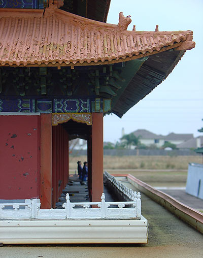
The ravages of the Katy Prairie have taken their toll on the models and unburied treasure at Forbidden Gardens, reports Brittanie Shey:
In 1996, when the museum first opened, it must have been an amazingly detailed sight. But [Forbidden Gardens founder Ira] Poon and his builders didn’t account for the Houston heat and humidity, which ruined a lot of the hand-painted details. Each terra cotta soldier used to hold a wooden weapon in his hand, but reckless children would climb into the display and take the swords to play with. When the soldiers started to break or peel, it was impossible to order more because the molds had been destroyed. [Weekend manager Alicia] Mendez said she and coworkers spend a few hours each summer having at the displays with Gorilla Glue to fix what they can.
COMMENT OF THE DAY: FLOOD MATH “Or, to put it another way, if there’s a 1% chance that a storm of that magnitude will occur in a given year, there’s a 99% chance that it will not occur. Also a 99% chance that it will not occur next year, etc. Which means there’s a better than 50% chance that a “100 year flood event†will occur sometime in the next 69 years. (log .5 / log .99 is approx. 69; 0.99 raised to the 69th power is just under 0.5) 500-Year = 0.2% Chance Storm Event = 50% probability within 346 years. 100-Year = 1% Chance Storm Event = 50% probability within 69 years. 50-year = 2% Chance Storm Event = 50% probability within 34 years. 10-Year = 10% Chance Storm Event = 50% probability within 7 years.” [GoogleMaster, commenting on Comment of the Day: I-10 and Bunker Hill Paving Report]
COMMENT OF THE DAY: I-10 AND BUNKER HILL PAVING REPORT “. . . as someone who lives on Westview and who has lived in the area mentioned (or near it) for 15 years… let me tell you what was paved over. -Ditches on either side of Bunker Hill between Longpoint and Katy freeway. -Old Katy road, which had grass on both sides and a ditch. -A little shop (maybe a car dealership I dont remember) that was on an island between both sides of bunker hill, dirt and green was taken from there -the already mentioned quarry which was NOT all pavement. I went there often and it was very much dirt. Cars would get stuck there when it rained. -The daniel area that was also not all paved where those new apartments are (where there is standing water when it DOESNT rain due to poor drainage). This is not a flooding that hasnt happened in 20 years, the houses here are much older than 20 years… these houses are 50+ years old and it has NEVER happened.” [Alma, commenting on The Detention Battle of Bunker Hill: Flooding Above the New Katy Freeway]
MORE PONDS, HUGGING BAYOUS Houston will spend $30 million in the upcoming fiscal year on detention ponds like those built under Project Brays. “About $20 million in federal Hurricane Ike relief money and $10 million in city capital improvements funding will be used to buy land and design and build basins that can hold hundreds of acre feet of water when the bayous become full, [Mayor] White said. City officials are evaluating sites along the Hunting, Greens, White Oak, and Halls bayous for new detention basins, said Andy Icken, deputy director of the Public Works and Engineering Department.” [Houston Chronicle]

Some residents of Long Point Woods are blaming the new and well-paved 48-acre Village Plaza at Bunker Hill shopping center along the north feeder road of the expanded Katy Freeway for the late-April flooding that damaged many homes between Bunker Hill Rd. and Blalock, south of Westview. Abc13’s Miya Shay reports, opting not to mention the neighborhood or the development by name:
[Resident Barbara] Hunt says homeowners grew worried when a large development along I-10 and Bunker Hill [was] allowed to be built without additional retention, and when heavy rain fell, it ran off the parking lots and into their homes. . . .
But Mayor White says the developers didn’t get special treatment because the property was already covered in asphalt before the developers bought the land and began building.
“If something is built, and somebody buys it from somebody where it already has some paved over and is already developed, we don’t have new detention requirements,” said Mayor White.
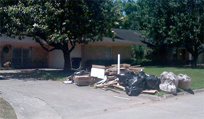
OFFICIAL FLOOD TALLY Storms in late April resulted in the flooding of 2,300 homes — the second-highest area total since Tropical Storm Allison hit in 2001. “The figure includes about 1,350 residences in Houston, 800 in unincorporated Harris County and the rest in other towns and cities within the county, said Heather Saucier, a spokeswoman for the county flood control district. More than half of the flooded houses were not in a mapped flood plain, a reminder that every property owner in Houston and Harris County is at risk for flooding and should purchase flood insurance, Saucier said.” [Houston Chronicle; previously on Swamplot]
FLOODING REPORT FROM THE NORTHWEST HOUSTON PRAIRIE BOWL The worst flooding damage from those late April storms centered around a swath of Highway 6 stretching from the Katy Freeway to 290 in northwest Houston. The heaviest rainfall was centered further west, along the planned path of the Grand Parkway Segment E. “[Jennifer] Bayles said her section of Bear Creek Village wasn’t within the 100-year flood plain when she and her husband bought their house 17 years ago. But it was added to the flood plain in new maps developed after Tropical Storm Allison in 2001, and the couple purchased flood insurance despite the steep premiums. ‘We’re well-insured; we’ll be fine,’ she said, but some neighbors don’t have the coverage they need. And their recovery efforts grew more complicated when they learned that if their homes sustained sufficient damage they would have to elevate when they rebuild. In the past few years, Bayles said, her street has flooded regularly during heavy rains, stranding residents in their homes for hours. But the April thunderstorms were the first time she’s had water in her house, she said.” [Houston Chronicle]
BRIDGELAND OVER THE FLOODWATERS Last week’s flooding in northwest Harris County provided only a taste of the problems likely to stem from development in the Katy Prairie along segment E of the planned Grand Parkway, say supporters of a Sierra Club challenge to existing floodplain maps in the Cypress Creek watershed. “An executive of Bridgeland GP, the company developing the 11,400-acre community, said in a Jan. 9, 2008, affidavit that the revisions sought by the Sierra Club would cost the company $28 million in flood mitigation measures that would ‘adversely affect’ the development. Despite the company’s efforts, the maps are being redrawn under U.S. District Judge Lee H. Rosenthal’s supervision. Rosenthal has stayed the lawsuit until October to allow time to complete the maps, but officials said they aren’t certain when the task will be finished. Preliminary revised maps [(PDF)] shown to the Houston Chronicle by [Sierra Club attorney Jim] Blackburn and the Harris County Flood Control District show a significant expansion of the flood plain in an undeveloped western segment of Bridgeland’s property and a reduction of the flood plain in other areas. . . . Asked if Bridgeland could assure Harris County residents that its development won’t worsen future flooding downstream, [Bridgeland VP of Sales] Houghton said, ‘I would have no problem guaranteeing that.'” [Houston Chronicle]

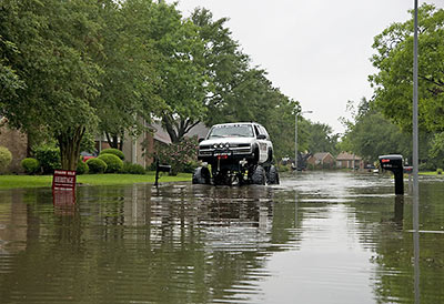
To start our latest installment of fun pix from around town, Jay Lee snaps scenes from this week’s flooding — in a neighborhood near Kirkwood and Briar Forest.
Oh, but there’s more!

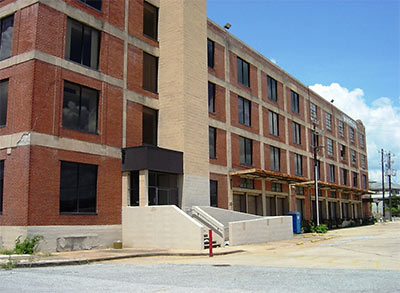
This 1923 former rice warehouse at the far eastern end of Washington Ave., used more recently as an annex for the Downtown post office on the other side of I-45, will become the city’s new permit office, reports Monica Perin in the Houston Business Journal. The building will replace the current 2-story office at 3300 Main St. in Midtown — which Public Works officials consider flood-prone — and consolidate permit offices from 3 other sites.
A LEED-certified renovation of the 4-story concrete-and-brick building, which sits on a 2 1/2-acre site Downtown — and which sat on the market for several years — is expected to be complete by the fall of 2010.
The property purchase is expected to close in July, along with council approval of a contract with Trammell Crow Co. as the developer, and Studio Red Architects as the design firm. . . .
“A building of this age and being a warehouse is relatively easy to recycle,†[Studio Red’s Bill Neuhaus] notes. “It lends itself to an open plan and lots of daylight. We can do an economical job here, and it will be an extremely pleasant working environment.â€
Permitting offices eventually will share space with the city’s new Green Resource Center, which is opening this week at 3300 Main St.
“The re-use of existing buildings is one of the greenest and most sustainable things we can do,†Neuhaus says.
He says the building’s prime location is part of the civic campus, next to the police department, the post office and rail station.
- City permits going green in rice warehouse [Houston Business Journal]
- 1002 Washington [LoopNet]
Photo of 1002 Washington Ave.: LoopNet
COMMENT OF THE DAY: THE BATTLE OF BUNKER HILL VILLAGE “Sounds like the high ground is still important to British occupation.” [Neil, commenting on Outlines of a Bunker Hill Village Theme Retreat]

