THE WOODLANDS BEATS HOUSTON TO ITS DOCKLESS BIKESHARING FUTURE  While Houston’s city council debates proposed new regulations that might allow as many as 6 competing companies to let loose as many as 3,500 new leave-’em-anywhere shared bicycles each across the city over the course of a year, The Woodlands has decided to go ahead with its own smaller kiosk-free program — with a single vendor. Mobike, a 2-year-old Chinese company now ranked as the largest bike-sharing organization in the world, will begin unleashing 50 to 100 bicycles, mostly intended to be used around The Woodlands Town Center. The company has operated in Washington DC since September. The Woodlands Township entered into the agreement with Mobike after a pilot program approved in October with Houston docked-bike vendor B-Cycle stalled. [Houston Chronicle] Photo: Mobike
Sign up for the Newsletter
Quicklink

PETER H. BROWN, 1936–2017 Peter Brown, who passed away yesterday, wore many hats — he was an urban planner, architect, neighborhood activist, city council member, and occasional rapper — as well several distinctive long scarves. Amidst other civic legacies, he leaves behind a substantial back catalog of YouTube videos — in which an unseen cameraperson chronicles Brown’s peripatetic musings on various aspects of Houston’s occasionally urban landscape. As “Pedestrian Pete” on both a Facebook page and YouTube channel of the same name, Brown explored “the good, the bad, and the ugly pedestrian conditions of Houston”: He scoured neighborhoods in search of traversable sidewalks, railed against car-centric attributes of the Heights Walmart, and strolled along Lower Westheimer in conversation with Annise Parker, who had defeated him in his 2009 run for mayor. Brown was 81. [Houston Chronicle; previously on Swamplot] Video: Pedestrian Pete
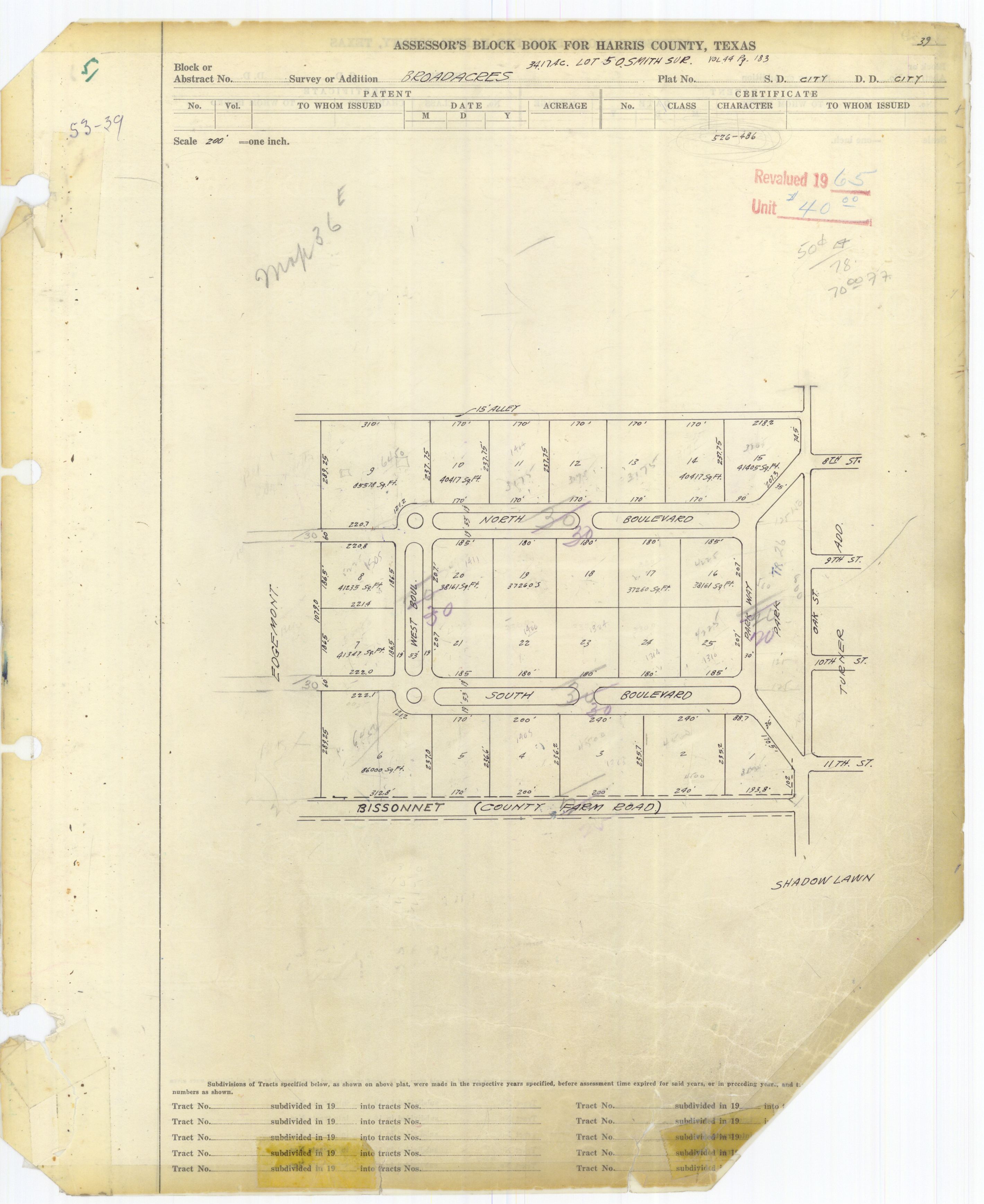
COMMENT OF THE DAY: BROADACRES’ LONG HISTORY OF PUBLIC-PRIVATE PARTNERSHIPS  “In a way, this is just the latest battle in a hundred year old fight. On a Preservation Houston tour of Broadacres (where we trespassed all over the esplanades), it was pointed out that the neighborhood was originally designed as a closed loop with the only access to the city via Parkway to the east. Houston, however, viewed the streets as public and forced the developers to cede ROW through the lots on the western side of the loop to connect North and South Blvds to their counterparts in the west. This is why North and South Blvds pinch weirdly right around West Blvd. — when you’re ceding expensive land, you only give the minimum required. . . .” [Cactus, commenting on Who Owns the Esplanades on North and South Boulevards?] Photo of Broadacres assessor’s map: HCAD

CITY: WE OWN THE BROADACRES ESPLANADES; HOA PREZ: NEIGHBORHOOD TRUST OWNS THE GRASS  The Houston Public Works department confirms in a press release that the esplanades and streets on North, South, and West boulevards in Broadacres are in the public right-of-way. But lookie here what Diane Cowen at the Chronicle reports: “Cece Fowler, president of the Broadacres HOA, said that it’s been determined that while the city owns the streets on North, South and West boulevards as well as the brick sidewalks that run down the middle of the esplanades, the Broadacres Trust owns the grass.” Also, according to Cowen, the park along Parkway Dr. is owned by the trust. The HOA placed NO PHOTO SHOOTS signs along the esplanades and in the park last Thursday, but removed some of them over the weekend. The rest were taken down on Monday, ahead of the city’s statement that “The public ROW is available for anyone in the community to use for legal activities, including personal photography. Signs and blocking the public ROW are not allowed without specific permission from the City of Houston.” The signs — 13 total according to Cowen — cost the HOA $1,300. [Houston Chronicle; previously on Swamplot] Photo: Swamplot inbox

BROADACRES HOA TAKES DOWN ITS ESPLANADE NO-PHOTOSHOOT SIGNS  The Broadacres Homeowners Association has removed all signs posted on the esplanades along North, South, and West boulevards welcoming visitors and telling them photoshoots are prohibited. As to whether the esplanades are public or private property — that’s still up in the air: “The homeowners association said the property was deeded to the group in the 1920s, and is looking for the documentation to enforce its ban.” The HOA initially placed the 11 signs on the esplanades last Thursday. [abc13; Previously on Swamplot]Â Photo: Swamplot inbox

WHO OWNS THE ESPLANADES ON NORTH AND SOUTH BOULEVARDS?  The president of the Broadacres Homeowners Association, Cece Fowler, tells the Houston Chronicle’s Diane Cowen last weekend that the neighborhood’s esplanades, as well as the park along Parkway Dr., are owned by the HOA. However, Cowen says that according to the City of Houston, the esplanades are part of the city’s Adopt-An-Esplanade program, making them public right-of-way. The dispute continues: “Fowler said that she and her board are conducting a title search to prove their ownership. She said the neighborhood has maintained and financed the esplanades and green space from the beginning.” That maintenance took a new turn last Thursday when 11 signs prohibiting photoshoots were erected on the esplanades. According to Fowler, the gatherings had become more than a nuisance: “up to 40 to 50” were occurring per week beneath the canopies of oaks that line the boulevards between Mandel St. and Parkway Dr. The 26 homeowners that make up the community discussed mitigation strategies like putting in speed bumps, adding a gate to the neighborhood, or hiring full-time security personnel before settling on the signs as a more cordial means of discouraging shutter-happy visitors. Now that they’re up, residents hope they’ll keep out flashbulbs as well as the props that sometimes come with them: “Fowler said some have brought in sofas and bookcases and one group drove a Jeep onto the esplanade, damaging the grass, brick sidewalk and sprinkler system. They throw confetti onto the ground and release Mylar balloons into the trees. And all bring photography equipment and crews that hang around for hours.”  [Houston Chronicle; previously on Swamplot] Photo: Swamplot inbox

COMMENT OF THE DAY: THE NORTH AND SOUTH BLVD. PHOTOSHOOT BATTLE IS JUST WARMING UP  “As a close relative of a Broadacres resident I will report what I know. Yes, the esplanades are privately owned and maintained by the homeowners and the signs are legal. The reason for the signs was the volume of people taking pictures. I have lived there for 15+ years and it has never been this bad. In the evenings you will have 2, 3, or 4 groups of people on each block taking pictures and it’s not just people that are the problem, it’s all of the props (sofa, chairs, tables, GLITTER, lighting) that they bring with them too. As some commenters have pointed out, some homeowners have approached those taking pictures and gotten back a lot of attitude and some form of “This is public property.†Err, well, no it isn’t actually. The signs were a compromise to discourage further pictures and serve as an initial educational campaign. If it backfires or the signs are ignored there will most likely be some sort of security enforced permitting in place or, the nuclear option, buying out the streets from the city and gating the neighborhood.” [BroadAcres Brat, commenting on New Signs Declare Photo Shoots Will No Longer Be Allowed on North and South Boulevards] Photo: Swamplot inbox

WHAT IT TAKES TO JACK A HOUSE  “Adam Bakir, a Houston builder and remodeler, does one or two home elevations a year. The job is akin to major surgery. Workers tunnel under the house, Bakir said, then raise the whole thing on jacks—the slab and the house that rests on it. Since Harvey, Bakir has received more than 20 inquiries about home elevation. If potential customers ask for a cost estimate, he’ll tell them: between about $75 and $100 per square foot. ‘If you have a 2,500-square-foot house, which is typical,’ he said, ‘the upper end of it would be about $250,000. The lower end, around $180,000.‘” [CityLab] Photo: Arkitektura Development

IN THE MISSOURI CITY AIR  Wild West Well Control is expected to finish capping an oil well this evening on McHard Rd. just west of the Fort Bend Tollway that blew out last night, sending foul-smelling fumes southeast into Fort Bend County. Nearby residents got a nose-ful: “Winds carried the smell across a large portion of the area; it is believed that the smell was from hydrogen sulfide. Total Fire has been conducting air monitoring in the area and has been unable to detect significant amounts of the chemical in the air.” [Fort Bend County OEM]
Photo: Fort Bend County OEM
Wild West Well Control is expected to finish capping an oil well this evening on McHard Rd. just west of the Fort Bend Tollway that blew out last night, sending foul-smelling fumes southeast into Fort Bend County. Nearby residents got a nose-ful: “Winds carried the smell across a large portion of the area; it is believed that the smell was from hydrogen sulfide. Total Fire has been conducting air monitoring in the area and has been unable to detect significant amounts of the chemical in the air.” [Fort Bend County OEM]
Photo: Fort Bend County OEM

COMMENT OF THE DAY: A QUICK ALLEN PARKVIEW VILLAGE RECAP FOR HOUSTON NEWCOMERS  “. . . Back in the 1920s, the 4th Ward was Houston’s version of Harlem during the Harlem Renaissance. Racist white city officials did not want a thriving African American community right next to a rapidly growing downtown and demolished a huge section of the community to build public housing (the decisive blow to the 4th ward would be extending the freeway through the community, effectively cutting it off from downtown). APV was designed by MacKie & Kamrath and was intended to be public housing. It ended up as all white housing for veterans. Eventually, African Americans moved in as whites moved out and headed to the suburbs. In the ’70s, as the City was booming again, City officials wanted to demolish APV as it, and much of the rest of the 4th ward, was falling into disrepair. Every single move after that was just controversy on top of controversy. The City was accused of moving Vietnamese immigrants into APV to dilute the number of African Americans who opposed demolition. Then, there was a big master plan project proposed to redevelop the entire area, a court case over demolition of APV and designation of APV and the Fourth Ward on the national register of historic places. In the end, more than half was demoed and replaced with new apartments in 2000. The original MacKie & Kamrath designed buildings are architecturally and historically significant. But, like the history of the 4th ward, Houston’s transient population knows very little about the trials and tribulations behind APV. So, it is an easy target to troll for hate on preservationists.” [Old School, commenting on Comment of the Day: An Alternative Plan for the Site Next to Allen Parkway Village] Illustration: Lulu

COMMENT OF THE DAY: AN ALTERNATIVE PLAN FOR THE SITE NEXT TO ALLEN PARKWAY VILLAGE  “. . . In an ideal world, I think that the City should’ve recognized that there was an opportunity for the HHA to acquire this site and work with a private-sector master developer to completely demolish the existing complex and integrate government housing into a much more intensively developed project on this extremely high-profile site. Doing so would’ve bypassed some of the issues that they’ve since encountered with the adverse SCOTUS ruling. It wouldn’t have been cheap, but it would’ve also tastefully incorporated government housing into a project that could have mitigated the externality of APV on the areas around it and established an open street grid. Doing so would’ve made everything around there and along the Buffalo Bayou much more desirable and accessible, and leveraged the tax base upward over a large area. However, that also wouldn’t have been uncontroversial; some people think that the original Allen Parkway Buildings are architecturally significant enough to warrant their preservation. In any case, that ship probably has sailed. . . .” [TheNiche, commenting on Your Best Look Yet at the Shiny Highrises Fitting Between Allen Parkway Village and the Federal Reserve] Image: Tianqing Real Estate Development/DC Partners

COMMENT OF THE DAY: THE ONLY MACKIE AND KAMRATH HOMES LEFT ON THE TIEL WAY LOOP  “. . . My husband and I drove around Tiel Way after the storm to check on all the MacKie and Kamraths. There were several homes on the street that flooded — and not just by a few inches but into their second levels. One of the things that make the Kamraths of this era (and really, many high-end midcentury homes) so gorgeous and unique is the abundant use of wood panels for all walls, doors, built-in storage cabinets and seating — everything. But it also makes them particularly expensive and hard to fix after extensive water damage.
As Swamplot reported earlier this year, the home at 2 Tiel Way was bought with the intention to restore but had so much termite and water damage it would have cost double to restore compared to a full rebuild price. So that’s what they are doing: rebuilding the same house. . . . It’s a controversial choice but in my opinion it’s the best architectural conservation alternative to demolition. But not everyone has the resources to undertake something like a full architectural rebuild. So while the demo of this house, one of Kamrath’s finest, is certainly a punch in the gut . . . I get it. They probably would have saved it if they could.
Tiel Way was the last concentration of MacKie and Kamrath’s great residential works, at one point having 7 homes on the loop. After this demolition we will be down to 2.5: the Gold Brick–awarded restoration at 67 Tiel Way (which thankfully, did not appear to have Harvey flooding issues), Kamrath’s own residence at 8 Tiel Way (definitely flooded, but appears to be safe at the moment), and the rebuild currently in progress at 2 Tiel Way.
48 Tiel Way won’t be the only midcentury treasure lost to Harvey, but it’s certainly one of the saddest to see go.” [Rabbit, commenting on Daily Demolition Report: Tiel Repeal; previously on Swamplot] Photo of 48 Tiel Way: HAR
“. . . My husband and I drove around Tiel Way after the storm to check on all the MacKie and Kamraths. There were several homes on the street that flooded — and not just by a few inches but into their second levels. One of the things that make the Kamraths of this era (and really, many high-end midcentury homes) so gorgeous and unique is the abundant use of wood panels for all walls, doors, built-in storage cabinets and seating — everything. But it also makes them particularly expensive and hard to fix after extensive water damage.
As Swamplot reported earlier this year, the home at 2 Tiel Way was bought with the intention to restore but had so much termite and water damage it would have cost double to restore compared to a full rebuild price. So that’s what they are doing: rebuilding the same house. . . . It’s a controversial choice but in my opinion it’s the best architectural conservation alternative to demolition. But not everyone has the resources to undertake something like a full architectural rebuild. So while the demo of this house, one of Kamrath’s finest, is certainly a punch in the gut . . . I get it. They probably would have saved it if they could.
Tiel Way was the last concentration of MacKie and Kamrath’s great residential works, at one point having 7 homes on the loop. After this demolition we will be down to 2.5: the Gold Brick–awarded restoration at 67 Tiel Way (which thankfully, did not appear to have Harvey flooding issues), Kamrath’s own residence at 8 Tiel Way (definitely flooded, but appears to be safe at the moment), and the rebuild currently in progress at 2 Tiel Way.
48 Tiel Way won’t be the only midcentury treasure lost to Harvey, but it’s certainly one of the saddest to see go.” [Rabbit, commenting on Daily Demolition Report: Tiel Repeal; previously on Swamplot] Photo of 48 Tiel Way: HAR

COMMENT OF THE DAY: ANOTHER WILLOW MEADOWS FAREWELL  “Willowgrove is a beautiful street, and sadly, I think we’re going to see several homes come down akin to what we saw & are seeing again in Meyerland (I believe there was another one yesterday). It’s predominately 1960s single-story ranch homes, many custom designed and some of them oversized vs. the rest of neighborhood, below a canopy of oaks that drape the street. It’s terribly sad that what it was before is just gone now. Willowgrove backs up to one of the feeder ravines that breached when the bayou did, and homes on both sides of it — Cliffwood and Willowgrove — took a massive hit compared to the surrounding streets that only had street flooding. The cap on flood insurance, if homeowners had it, wouldn’t cover the value of those homes. I’ve had neighbors ask me, and I genuinely do not know — are those concrete ravines/mini-bayous supposed to drain/connect to Willow Water Hole at some point? Was that already supposed to have happened? If so, what was the delay?” [Heather, commenting on Daily Demolition Report: Lynn Parked] Photo of 10202 Willowgrove Dr. interior (now for sale): HAR

COMMENT OF THE DAY: NO NEED FOR A TRAIN ON I-10 WHEN YOU CAN JUST PARK-AND-BUS  “. . . The train isn’t going to travel that much faster than buses, if at all. Also, buses in the Katy corridor make just one stop at most between the burbs and Downtown (the major route is express from the Park-and-Ride lot direct to Downtown). And people play on their phones on the bus (have you never been on one? the park-and-ride vehicles have nice cushy seats and baggage racks). And unless one’s destination is outside the CBD, no transfers are required; you are likely dropped off within a few blocks of your destination, an easy walk. Furthermore, on the highly used Park-and-Ride routes the buses leave every several minutes; you don’t have to time your arrival, the wait time to depart is minimal. Commuter rail never works like that (though light rail can).
The assumption that rail is going to provide superior service simply isn’t true. In fact, it’s likely to be worse service for the patrons than what we have now with the Park-and-Ride buses. Especially since most everyone will have to drive to the station anyway, so no difference there.” [Local Planner, commenting on Was It a Good Idea To Derail I-10?] Photo: Energy Corridor
“. . . The train isn’t going to travel that much faster than buses, if at all. Also, buses in the Katy corridor make just one stop at most between the burbs and Downtown (the major route is express from the Park-and-Ride lot direct to Downtown). And people play on their phones on the bus (have you never been on one? the park-and-ride vehicles have nice cushy seats and baggage racks). And unless one’s destination is outside the CBD, no transfers are required; you are likely dropped off within a few blocks of your destination, an easy walk. Furthermore, on the highly used Park-and-Ride routes the buses leave every several minutes; you don’t have to time your arrival, the wait time to depart is minimal. Commuter rail never works like that (though light rail can).
The assumption that rail is going to provide superior service simply isn’t true. In fact, it’s likely to be worse service for the patrons than what we have now with the Park-and-Ride buses. Especially since most everyone will have to drive to the station anyway, so no difference there.” [Local Planner, commenting on Was It a Good Idea To Derail I-10?] Photo: Energy Corridor

WAS IT A GOOD IDEA TO DERAIL I-10?  Earlier this week Harris County Judge Ed Emmett appeared to pass judgment on one aspect of the Katy Fwy. widening completed almost a decade ago: “We cannot go back in time and undo some poor decisions, but we can learn from those decisions. One of the most glaring mistakes was the failure to convert the abandoned Katy rail line to commuter rail. Think about it, we had a straight shot from Katy all the way into Downtown.†But ripping up the tracks did not render a future rail line along the path of I-10 completely impossible, notes Dug Begley: “Though the rail line was removed, Metropolitan Transit Authority paid for overpasses along I-10 to be built to rail standards, meaning that if the region ever wanted to use the freeway for light rail, that is possible. Larger, commuter, trains, however would not be able to operate in the freeway.” [Houston Chronicle] Photo: cemaxx (license)
