TERRY HERSHEY, 1922-2017 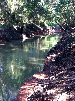 The stretch of Buffalo Bayou running between the Addicks and Barker reservoirs and Shepherd Dr. looks the way it does today in large part because Terry Hershey and some friends spotted the unannounced work to pave and reroute the bayou — and raised some hell about it with the county, the Corps of Engineers, and others. The early actions of Hershey and her associates stopped the pave-over, led to the founding of what became the Bayou Preservation Association, aided the passage of the National Environmental Policy Act (which requires public involvement in projects that could impact the environment), and helped to catalyze Houston’s environmental movement. Hershey’s legacy includes founding, laying groundwork for, and participating in many other organizations to protect green space and environmental quality in Houston and throughout the state, many of which are still active today; the 6-mile park along Buffalo Bayou between Hwy. 6 and Beltway 8 is named for her. Hershey passed away today at age 94. [Houston History, Houston Chronicle] Photo of Terry Hershey Park: Save Buffalo Bayou
Sign up for the Newsletter
Quicklink

WHERE YESTERDAY’S SEWAGE OVERFLOWS FLOWED  Yesterday’s floodwater caused diluted sewage releases from the 69th St. Wastewater Treatment Plant, located near the crossing of 69th St. over Buffalo Bayou (just upstream from the new Buffalo Bend Nature Park and the Port of Houston Turning Basin). Houston Public Media notes the city’s rundown on where and how much: “The estimated volume of released wastewater as of 6 p.m. Wednesday was approximately 500,000 gallons at Halls Bayou at US 59 at Parker Rd.; approximately 160,000 gallons at White Oak Bayou Near Interstate 45 N. at Wrightwood St.; and approximately 500,000 gallons at Buffalo Bayou near the University of Houston Downtown, officials said.” The city also says anybody using their own private water wells in those areas should get them checked out (and boil water in the meanwhile). The 69th St. plant is the city’s largest wastewater facility, as well as a production site of Hou-Actinite fertilizer. [Houston Public Media; previously on Swamplot] Photo of 69th St. Wastewater Treatment Plant: Webber

TONIGHT’S AREA FLOODING SYMPOSIUM CANCELLED BY AREA FLOODING 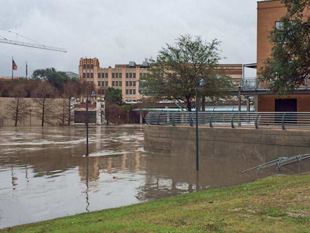 The free public Flooding and Storm Surge Symposium previously planned for this evening at the George R. Brown Convention Center is being postponed, on account of it’s flooding right now. The event would have included 2 panel discussions with flood-minded folks from a variety of public and private sectors and institutions, gathering to talk about the city’s flooding and storm surge issues and possible solutions; the Urban Design Committee of the Houston chapter of the AIA says the event will be rescheduled. [Houston AIA] Photo of this morning’s high water at Allen’s Landing: Christine Wilson

CREWS NOW PUMPING REPLACEMENT BEACH SAND ALONG GALVESTON SHORELINE 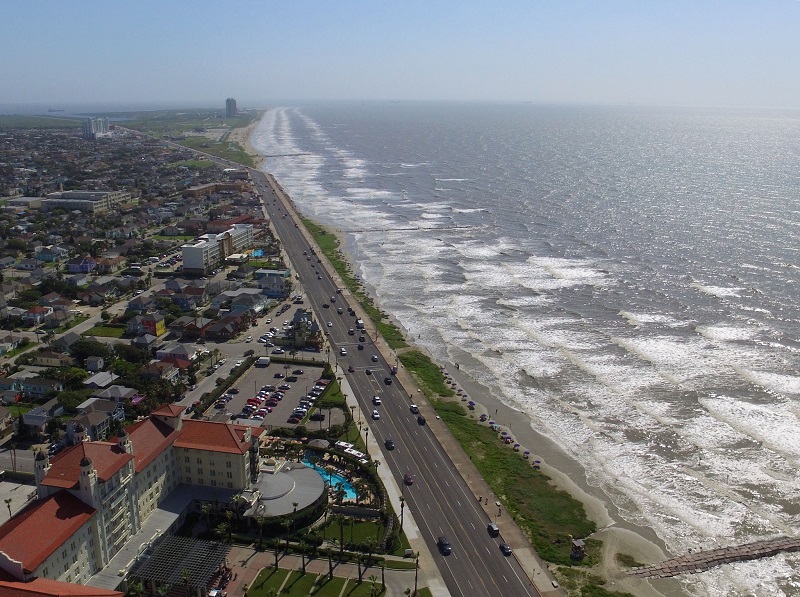 The Galveston.com Sand Cam was pointed east yesterday morning to capture the action as work crews pumped a slurry of sand from the Big Reef area on the northern end of the barrier island onto the beaches along the seawall, as part of a $19.5 million project intended to add between 100 and 150 feet of beach back to the eroded shoreline. A few smaller sand-adding projects have taken place over the last few years, winning a nod from the American Shore & Beach Preservation Association; Kelly de Shaun of the Galveston Parks Board tells Harvey Rice that this round of sanding is proactive maintenance, unlike the sand trucked in back in 2009 after Hurricane Ike paid a visit to the island. [Houston Chronicle] Photo of Galveston seawall: Russell Hancock via Swamplot Flickr Pool

HUD ORDERS GO-AHEAD ON BRIARGROVE AFFORDABLE HOUSING PROJECT OR SOMETHING KINDA LIKE IT 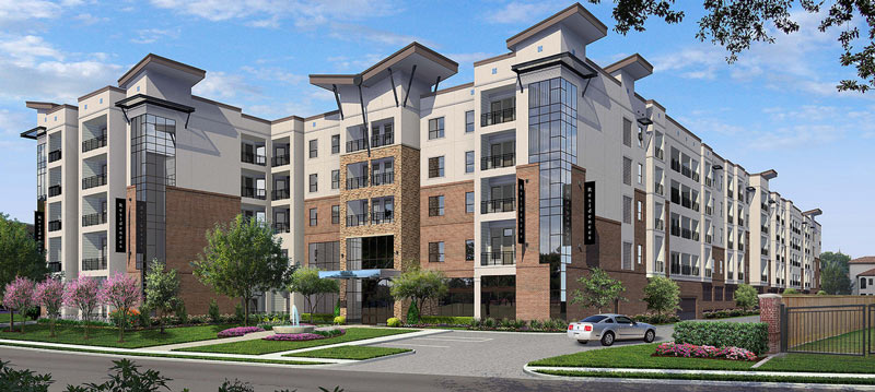 Houston Public Media reports that the city is mulling over its options with regards to the letter sent last week by the Department of Housing and Urban Development, which relayed the agency’s findings that the nixing of the mixed-income apartment complex at 2640 Fountainview Dr. was based in part on “racially motivated local opposition.” Among other things, the letter orders the city to okay the project (or a similar project within another “low minority and high opportunity” census tract), to develop a plan to promote other similar projects in other low-poverty areas, and to work out incentives for property owners in those same areas to accept housing vouchers.  [Houston Public Media; previously on Swamplot] Images of proposed apartments at 2640 Fountainview Dr.: Houston Housing Authority

CITY-WIDE DRAINAGE SWAT TEAM POSSIBLY BANKROLLED BY HEIGHTS WATERWORKS SALE 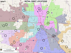 Mayor Turner announced plans for a dramatically monikered Storm Water Action Team at this week’s council meeting, along with 22 projects at the top the program’s initial list, based on metrics of urgency like frequency of 311 calls. The goal of the program is to deal with non-bayou-centric flooding issues like collapsed culverts and junk-clogged drainage ditches; flood czar Steve Costello said after the council meeting that the city wants to resolve the fixable issues at each site within 90 days of a site visit and initial drainage triage. Meagan Flynn writes this week that the $10 million currently budgeted for the program comes mostly from a one-time sale of city land; that land might well be the Heights Waterworks properties at W. 20th and Nicholson streets, which were sold to apartmenteer Alliance in mid-December for a reported $15.2 million. [Houston Press; previously on Swamplot] Draft map of 22 SWAT project locations: City of Houston SWAT program materials

COMMENT OF THE DAY: THE TRANSMISSION LINES ARE ALWAYS DEEPER ON THE OTHER SIDE  “While working with Entergy in New Orleans (12 plus years ago), at every public meeting I went to, citizens always complained about the city’s third world look when we would tell them burying power lines was not a part of the long-term plan (maintenance and upgrades). They would frequently state that no other major city had above ground lines — and that on their most recent business trip to Houston, they did not see any above ground,  and that we should follow Houston’s lead.” [Nend, commenting on Electrical Transmission Lines About To Get Really High by the Dog Park at 59 and 610] Photo of current and replacement electrical transmission towers at Westpark Dr. and 610: Swamplot inbox

UN-RE-ZONING OF MISSOURI CITY TRACT PAVES WAY FOR SHIPMAN’S COVE MASTER PLANS 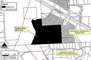 The Missouri City council voted last week to approve a “planned development” zoning classification for a woody 95.3-acre tract at the edge of the Creekmont and Newpoint Estates subdivisions off Hwy. 6 at Watts Plantation Rd., which master plan planner Ashton Woods wants to turn into a 287-unit housing development called Shipman’s Cove. The January vote came after a determination by the city’s attorney that the failed September vote on the same issue had technically passed: Councilmembers now says that the vote to change the undeveloped land’s zoning classification (an act that would have required a 75 percent majority among the 7 council members, and fell 1 vote short of that hurdle) actually only counted as a vote to zone it for the first time — which only needs a simple majority for approval. Amelia Brust reports that neither the city council nor city attorney “explained what prompted the further review, nor did they identify the outside legal counsel hired by the city” that helped review the situation; Missouri City mayor Allen Owen also said at the time of the vote that multiple lawsuits looked to be in the works. [Community Impact] Image of planned site of Shipman’s Cove: Missouri City
Feels Like the First Time

HOUSTON AND SAN ANTONIO COMPANIES JOIN UP IN SPROUTING TEXAS POT MARKET Meanwhile, in La Vernia: Kyle Hagerty provides an update on Houston-based aeroponics company Indoor Harvest’s plan to team up with San Antonio-based Alamo CBD in an attempt to become of the medical pot dispensing organizations the state of Texas will have to license as part of the 2015 Texas Compassionate Use Act. If all goes as planned, Indoor Harvest and Alamo will merge, then set up a 10-acre property in La Vernia, TX, to provide Vermont-based Vyripharm with pot products of specific chemical profiles — most importantly, with consistent levels of cannabidiol, a non-psychoactive pot compound being studied for potential treatment of certain cancers and forms of epilepsy. Vyripharm, in turn, is setting up research agreements with a bunch of medical institutions in Houston and Galveston.  Hagerty notes that legal pot is one of the fastest growing industries in the country — though as UH professor Gina Warren pointed out this summer, indoor pot farming is a hugely energy- and water-intensive industry, with little regulatory infrastructure in place yet to address potential local or regional impacts. [Houston BisNow]
COMMENT OF THE DAY: CROSSING A LINE ON FLOOD CONTROL  “You either pay for the fixes, or let residents continue to be subjected to higher insurance premiums, maintenance, and rebuild costs — slowly depriving the city of tax revenue. At some point, property values will appreciate to the point where making the fixes may have been the smart thing to do. Not saying it’s financially practical of course. What was the property damage total for the past 2 years of flooding, though?” [joel, commenting on Just How Much Flooding Is Too Much Flooding for Houston?] Illustration: Lulu

COMMENT OF THE DAY: A STEAMY BACKWARD GLANCE TO METEOR’S PRE-SHOWER DAYS  “Oh, the memories of 2306 Genesee St., circa the late 1970’s! When the space was Houston’s 3rd bath house . . . All sorts of debauchery took place within those walls. I, of course, will not divulge what happened there.” [Happy Go Lucky, commenting on Meteor Crashes to the Ground in East Montrose] Photo of 2306 Genesee St., prior to demolition: Meteor Lounge

JUST HOW MUCH FLOODING IS TOO MUCH FLOODING FOR HOUSTON? 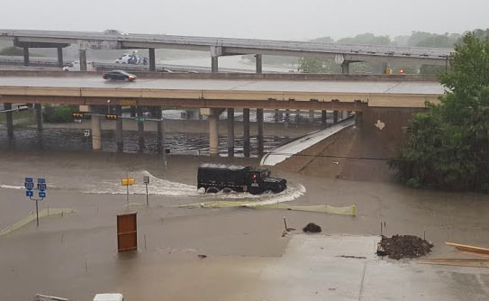 We pretty much know what we would have to do to stop most Houston flooding, writes Dylan Baddour as the calendar flips to 2017.  Potential paths to drier ground for the city include a multitude of complex region-wide tasks, including changes to waterways across the county, adding thousands of acres of detention space, and potentially addressing the cumulative impacts of seemingly minor small-scale building practices.  The cost of upgrading the whole system, including buyouts, bayou widenings, and utility rerouting, is estimated by the county flood control folks at around $27 billion — and that’s just to get protection up to so-called 100-year storm levels; Houston has had 8 such storms in the past 27 years, and the Tax Day flood was fueled by a much larger event. “What needs to be decided,” Baddour writes, “is how far taxpayers are willing to go. Cars don’t have airbags to absorb a hit from a train. Should Houston have a drainage system to contain a biblical storm? Where does the city draw the line?” City flood czar Steve Costello tells Baddour that the city has to do something, however, to avoid passing on a “potentially insurmountable problem” to future Houstonians. [Houston Chronicle] Photo of N. Braeswood Dr. at 610 on April 17, 2016: Chris Klesch

SWAPPING PERSPECTIVES ON THE HOUSTON STRIP MALL MODEL  “They’re neighborhood centers,†not strip malls, developer Ed Wulfe insists to Katharine Shilcutt in this month’s issue of Houstonia. And call them — all 25,000 or so in the region — what you will, they’ve been scratching the relatively-high-density retail itch for Houston’s sprawling residential areas since WWII. Shilcutt admits that “in the Bayou City, defending the ubiquitous strip mall carries the same whiff of insanity as defending giant tree roaches or mosquitoes. . . . Their aesthetic merits are dubious; their environmental impact, baleful.” But is there any more pure distillation of Houston? (Shilcutt goes on to relay her discussion with restaurateur and actual strip mall tenant Kaiser Lashkari, who owns Himalaya restaurant in Olympic Center off Hillcroft and agrees that there are some benefits to the strip mall model. When asked if he would move to a freestanding building given the opportunity, his answer is still an unequivocal yes.) [Houstonia] Photo of strip center at 13326 Westheimer: Swamplot inbox

PIPELINE PROTESTERS LEAVE FREEZING N. DAKOTA, HEAD TO TEXAS TO CAMP Meanwhile, in Alpine: Several groups of environmental activist-types are currently setting up a series of long-term protest camps along the planned route of the Trans-Pecos Pipeline, which would send natural gas to Mexico from near Ft. Stockton by crossing beneath the Rio Grande. Like the Dakota Access pipeline (which the Army Corps said earlier this month it’s gonna try to reroute),  the Trans-Pecos is another Energy Transfer Partners project — though the company was already running into opposition in the region long before the Dakota protests made the national news, from what Rachel Monroe describes as an unlikely coalition of “archaeologists, McDonald Observatory astronomers, hippies, and ranchers.â€Â The 1st camp was to have opened yesterday near Alpine; David Hunn writes this week that a handful of the same folks from the Dakota protests have already arrived in the region, and that 2 more camps are planned to open early next year, in the ghost town of Casa Piedra (near the edge of Big Bend Ranch State Park) and Toyahvale (home to Balmorhea State Park and San Solomon Springs — and near which Houston-based Apache Corp. is currently planning major drilling operations). [Houston Chronicle, Texas Monthly]
AN EERIE SURVEY OF NORTHWEST MALL’S APACHES, ALCOHOLICS, AND CHRISTMAS CAST 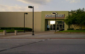 A spiritual throwback to John Nova Lomax’s semi-regular walkumentaries of various Houston neighborhoods is part of January’s edition of Texas Monthly: an account of his recent trek through sorta-back-from-the-dead shopping center Northwest Mall. Lomax ponders the center’s past, present, and future while interviewing the locals (like the photo-ready Santa and elf team) and collecting dramatic snippets of eavesdropped conversation outside the mall’s Alcoholics Anonymous meeting facility (located not too far from the alcoholic bundt cake shop). Lomax writes that he sees the decidedly not-as-decrepit-as-it-used-to-be complex, complete with mysteriously closed Southern Apache Museum and $2 hurricane simulation tube, as a “window into modern, cosmopolitan Houston,” noting that “today’s Northwest Mall is more identifiably Bayou City than it was in the boom times. Where it was once just another outpost of corporate American capitalism, it is now as diverse as the city around it. . . . What you will find among these [one-off shops] you will find nowhere else, and the scenes you will take in are often exotic, quirky, or somewhat spooky — and occasionally some combination of all of the above.” [Texas Monthly; previously on Swamplot] Photo of Northwest Mall Entrance C: Moni
