
Simply smashing houses.
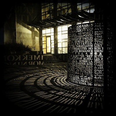
Photo of Jim Sanborn’s sculpture outside the University of Houston’s M.D. Anderson Library: Molly Block via Swamplot Flickr Pool


Last week, the city and the Army Corps of Engineers agreed to build almost 14 new miles of hike and bike trail — from I-45 to west of 288 — along Sims Bayou. The project, construction for which could begin as early as November, will cost about $7 million, and it will connect 7 city parks: Reveille Park, Stuart Park, Law Park, Sims Bayou Park, the County’s Hill at Sims Park, Scottcrest Park, and Townwood Park.
The first stretch to be built will be a 10-ft.-wide 3.1-mile span from I-45 to Stuart Park on Bellfort, just a few miles from Hobby Airport. Also included in the trail construction? The usual swag: Picnic tables and pavilions, benches, drinking fountains, lighting, and parking lots.
Photo of Sims Bayou: Allyn West
COMMENT OF THE DAY: WHEN IT RAINS, IT’S RECOUPED  “I live close to Buffalo Bayou. I lost two cars during a heavy rain in 2009. The water came up too fast to save the cars. By the time I found out they were flooding they were in a couple feet of snake infested water. The insurance company paid up right away and didn’t raise my rates. These people should have no problem if they have insurance.” [jgriff, commenting on Headlines: Putting the Creek in Cross Creek Ranch; Flooding the Omni Hotel Parking Lot] Illustration: Lulu
DITCH REPAIRS, BRIDGE REPLACEMENT TO CLOSE STRETCH OF SAN FELIPE FOR NEXT 2 WEEKS  San Felipe St. near Mid Ln. and the Loop is going to be out of commission for about 2 weeks, according to the Harris County Flood Control District: After tonight’s rush hour subsides, workers will move in to remove concrete from the sides of the eroding and underperforming drainage ditch, shown here, and install closed culverts. And that means the 50-year-old bridge on San Felipe will need to be demolished and replaced. The area to be closed is near the new Liberty Kitchen spot and the luxury apartments under construction on Briar Hollow Ln. [HCFCD; previously on Swamplot] Photo: HCFCD
GOOD FIRST WARD COFFEE SHOPS ARE HARD TO FIND  Houstonia Magazine’s Nick Panzarella likes what he sees — er, drinks at Paper Co., a reincarnation of Taft Street Coffee that’s moved in behind that Marfreless-like blue door at the Ecclesia Church on Elder St. But this door — though just around the corner from the artist lofts at the old Jefferson Davis Hospital, it opens up to a permashaded no person’s land beneath I-45 — seems to give Panzarella some pause: “Its location, being tucked into a dead end on the edge of the First Ward, is its largest drawback.” [Houstonia Magazine; previously on Swamplot] Photo: Allyn West
")
Here’s a plan that looks to plug in to Metro’s still-under-construction Southeast Line and redo about 8 blocks along Scott St. in the Third Ward between UH and TSU. Though the plan, drawn up by LAI Design Group and dubbed “University Place Redevelopment,” is provisional, it appears to have in mind something like what the rendering above shows: A reshaped streetscape on Scott St. that would combine apartments, restaurants, shops, offices, and community buildings.
The first phase appears to call for a strip center facing Scott between Holman and Reeves, with 289 1- and 2-bedroom apartments and a parking garage in the rear:


So much for total environmental control, huh? The Foley’s, then Macy’s, at 1110 Main St. is no more, succumbing to a helluva lot of dynamite early Sunday morning. Completed in 1947 and designed by Kenneth Franzheim, the 10-story, 791,000-sq.-ft. building was the last department store Downtown. It’s still not clear what will be going up once the retail rubble is cleared from this block bound by Main, Travis, Dallas, and Lamar, though an employee at Hilcorp — which is connected to 1110 Main Partners, the entity that owns the property — has told Swamplot it’ll be “a regular looking office building tower over 20 stories high.â€
But we’re getting ahead of ourselves. Why not revel, for a moment, in the glorious dust?

Swamplot’s Daily Demolition Report lists buildings that received City of Houston demolition permits the previous weekday.
Here are soon to be yet another crop of fine examples of things no longer present:
Photo of GreenStreet after Foleys’s demo: Jon Morris
COMMENT OF THE DAY: SIGHTS UNSEEN  “Pictures don’t sell homes. People don’t buy sight unseen. At best, high quality photos will give you a few more showings (by people who were enticed by the photos, thus not likely your buyer).
List a property in Montrose, and take 6 photos of various homeless people, old-man armpits, and urinals, and it’ll still sell in a day.” [Cody, commenting on Houston Home Listing Photo of the Day: The Back Carpet] Illustration: Lulu
“Pictures don’t sell homes. People don’t buy sight unseen. At best, high quality photos will give you a few more showings (by people who were enticed by the photos, thus not likely your buyer).
List a property in Montrose, and take 6 photos of various homeless people, old-man armpits, and urinals, and it’ll still sell in a day.” [Cody, commenting on Houston Home Listing Photo of the Day: The Back Carpet] Illustration: Lulu
WHAT TIME THE EXPLOSIONS DOWNTOWN WILL WAKE YOU UP , 1110 Main St., Downtown, Houston") A rep from Metro confirms that the booms of the controlled demolition of the former Foley’s at 1110 Main St. will begin booming between 7:10 and 7:20 this Sunday, September 22. (That’s 10 minutes past sunrise, for all you morning people.) And if you’ll be driving Downtown to find parking and get yourself in implosion position, note that the street closures that Swamplot reported yesterday will begin at 6 a.m. [Metro; previously on Swamplot] Photo of Foley’s: Jim Parsons
A rep from Metro confirms that the booms of the controlled demolition of the former Foley’s at 1110 Main St. will begin booming between 7:10 and 7:20 this Sunday, September 22. (That’s 10 minutes past sunrise, for all you morning people.) And if you’ll be driving Downtown to find parking and get yourself in implosion position, note that the street closures that Swamplot reported yesterday will begin at 6 a.m. [Metro; previously on Swamplot] Photo of Foley’s: Jim Parsons
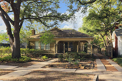
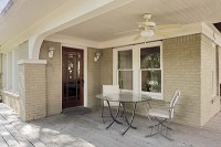
The wraparound porch of this updated 1928 bungalow in Lancaster Place lands on the side of the home on the far side of the former Fiesta Mart site 3 lots to the west, where the announced 8-story Finger apartment project (The Susanne) is about to go up. The recessed porch’s overhang shades the bedrooms that line up along the driveway, but the living and dining side of the property appears to get plenty of light — for now at least –Â from the west and apartment-free south. The home appeared on the market Wednesday; it has a $520,000 asking price.


