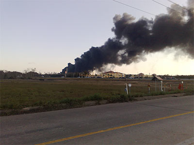
PICKING UP CASH FOR THE CHEMICAL SPEW How did Harris County government swing half a million dollars in cash from Shell Chemical? The company is turning over that amount as part of a settlement covering 5 unreported chemical releases between April 2008 and March 2010 at the company’s Deer Park plant on Hwy. 225 just east of Beltway 8. According to Harris County’s lawyer on the case, Shell Chemical also made an “important concession,” which will likely result in more advance warning of similar future windfalls headed our way: Shell says it’ll now alert the county’s local pollution control office, and not just state officials, of “pollution events.†[Pasadena Citizen]
Tag: Air Quality

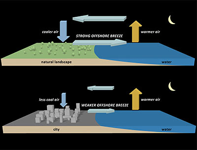
A new study from the National Center for Atmospheric Research documents how Houston’s vast expanse of paved surfaces allows the city to hold onto locally developed air pollution for longer periods of time, and prevents breezes that would otherwise naturally develop from sending all that nasty smog and stuff to outlying areas. Concrete and asphalt paving helps by soaking up heat during the daytime. This keeps land areas relatively warm overnight, which means there’s a lower contrast between land and sea temperatures during the summer. The result? Much less of those smog-stealing nighttime summer breezes. During the daytime, Houston buildings help to block local winds and keep things more still in the afternoon. Just another way standard development practices allow Houston to be a responsible steward of its own locally produced airborne products.
Raw helicopter footage from abc13 of the fire currently raging at the Enterprise Products natural gas fractionation facility at 135 Sun Oil Rd., just east of Hwy. 146 in Mont Belvieu. By 3:55 in, the view gets better, and you can hear the commentator noting that the fire was visible from above Hobby Airport, just 30 miles away.
- Explosion, fire burning at Mont Belvieu facility [abc13]
- Plant burns in Mont Belvieu [Houston Chronicle]
Video: abc13
RAINY DAYS AND SUNDAYS ALWAYS GET ME DOWN “So it stinks like something awful again where I am today (the Heights). I look at the calendar and realize it’s been 2 prime dump days in a row, a wet Sunday followed by a national holiday. An old friend of mine who grew up on the east side used to say that a Sunday when it rained was the perfect day for all the refineries to release their nastiest emissions, because the rain masked it and for some reason there wasn’t any enforcement on the weekend. I’m wondering where else in the city it smells like what I’m smelling, and is there any truth to the rainy-day-dump theory? That’s some strong anecdotal evidence in my nostrils.” [Swamplot inbox]
THE LUNCHTIME RACKET AT BRADY’S LANDING Visiting the Houston Ship Channel on a promotional “toxic tour” of sites where the air will likely be invigorated once nearby refineries get chugging on the Canadian tar sands headed for Houston through the proposed Keystone XL pipeline, Perry Dorrell stops by the scenic Brady’s Landing Restaurant during lunchtime: “During the evening the restaurant is like many others in the city: bustling with patrons and staff, the parking lot busy with diner traffic. During the day, however, the region’s oppressive noise is invasive and obnoxious; right next door a facility is dry-docking barges and a team of several men operating industrial-grade pressure washers removes barnacles from their hulls. Cranes swing containers to and from foreign freighters, crashing and booming. The warehouses directly across the channel are beehives of activity, with stevedores operating forklifts, shifting and stacking and slamming pallets of material. It was amazing how loud it was, a phenomenon I never noticed in my visits at night to dine. On the other side of the restaurant a steamshovel was loading and unloading a smoking, 200-hundred-foot high brown pile of … something, fertilizer-like in appearance. No accompanying aroma, fortunately. Maybe we were upwind.” [Brains and Eggs; previously on Swamplot]
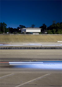
COMMENT OF THE DAY: WHEN ALL WE SEE IS THE VIEW TO A KILL  “I like the ‘idea’ of this house, and the view of downtown is very nice. However, what about the well-documented health [effects] of living near (or extremely near, in this case) freeways? Are the increased risk of cancer, heart disease, asthma, premature births and so on a worthwhile trade-off for living in a conceptual design statement? Maybe they have some kind of cool air-pollution filtration system….” [Mies, commenting on Self Directed: A Modern House Angled for 288’s Best Freeway Views]

That proposed underground pipeline linking Houston to the luscious bounty of Canadian strip-mined tar sands will sneak into Houston from the east, and won’t even make it inside Beltway 8, according to this map released by the State Department. The line is scheduled to carry up to 500,000 barrels a day of crude oil to Texas alone — probably more than 8 times as much oil as the successors to the Deepwater Horizon are currently delivering directly to the Gulf of Mexico.
TransCanada plans to stitch the pipeline over the Ogallala Aquifer, which supplies water to part of Texas and much of the Midwest.
The pipeline also would cross more than 30 rivers and streams in Texas and could run underneath the Big Thicket National Preserve, said environmentalists and landowners.
Texas and Oklahoma portions of the 2,000-mile-long Keystone XL pipeline are still under review; this Friday is the deadline for public comment on the draft environmental impact statement released in April.
[TransCanada VP Robert Jones] defended the project, saying pipelines are the safest way to transport oil. The company will use pipe that has been employed safely in Canada for years and bury it 4 feet deep, he said.
Jones also downplayed concerns about Houston’s air quality, saying the Canadian crude is replacing oil from other sources and has not led to changes in the refineries’ pollution permits.
But [Matthew] Tejada, of Air Alliance Houston, found fault with TransCanada’s position. He said the tar-sands crude when refined will emit higher levels of sulfur dioxide, nitrogen oxides and particulate matter into the air than conventional oil.
- Proposed oil pipeline to Texas raises worries [Houston Chronicle]
- Keystone Pipeline Project [TransCanada]
COMMENT OF THE DAY: CLEAR LAKE CITY CLEANS UP NICELY “Is there a discount [for homes near chemical plants]? Hell yes! And it’s for lots of reasons: 1) real or perceived pollution, 2) real or perceived high crime, 3) low elevations, 4) higher property insurance rates, 5) fewer nearby white collar jobs, and 6) living there indicates to snobs that you’ve got a low social status. Most of the discount is unwarranted, but it’s a self-fulfilling prophecy. Look at Clear Lake City; parts of it are only about 1.5 miles from the nearest chemical plants. It was developed upon depleted oil fields and is adjacent to still-active fields. (It was developed by a subsidiary of Exxon!) It’s adjacent to an airport. It has a low elevation. But all that stuff is out of sight, out of mind, and so there’s no stigma.” [TheNiche, commenting on House Shopping in the Chemical Discount Zones: Finding Houston’s Less-Toxic Neighborhoods]
HOUSE SHOPPING IN THE CHEMICAL DISCOUNT ZONES: FINDING HOUSTON’S LESS-TOXIC NEIGHBORHOODS “A commenter on your blog who says he works at a chemical plant recently wrote that a neighborhood 1 mile from a chemical plant ‘is never going to be an “OK” neighborhood.’ Is there a single citywide map that shows where all these plants are, so I can find a place to live accordingly? And how far do I have to be from a chemical plant to be ‘OK’? 5 miles? 20? I presume there’s no absolute answer. But there’s got to be a de facto ‘discount’ on homes in neighborhoods that are within certain radiuses of the toxic stuff, right? If so, how far do the discount zones extend? Could someone draw that map for me?” [Swamplot inbox]
COMMENT OF THE DAY: WE’RE FROM THE TEXAS MEDICAL CENTER AND WE’RE HERE TO HELP “Given all the refineries, industrial plants, chemical plants, railroads, stagnant swamps and cesspools, traffic pollution, and the like that plague this hellhole of a town, it is a freaking wonder that Houston doesn’t lead the nation in cancer cases.” [Random Poster, commenting on Today’s Odor in Baytown Is Brought to You by ExxonMobil]
TODAY’S ODOR IN BAYTOWN IS BROUGHT TO YOU BY EXXONMOBIL The most recent smell, of rotten eggs, has been claimed by the folks at ExxonMobil’s Baytown Refinery. Fortunately, local news outlet Reuters UK is on the story, filing one of the few reports on the incident, which we quote here in full: “Exxon Mobil said Wednesday there was an operational issue at its 562,500 barrel-per-day refinery in Baytown, Texas but gave no details as to the scope and units involved. ‘I can tell you there was no impact to production,’ said Kevin Allexon, a spokesman for the company.” [Reuters UK]
COMMENT OF THE DAY: AND ON ANY RAINY SUNDAY “Well, Christmas Day and New Year’s Day are coming up, an opportunity for the Annual Unscientific Anecdotal Take A Whiff Holiday Bingo. First thing in the morning on these two holidays, open your windows or step onto your porch or balcony, face the southeast, and take a big sniff of the air. 99% guarantee you’ll get a strong odor of Eau de Ship Channel. After 20 or so years of this I’m convinced that the plants take advantage of the holiday (no one manning the phones at TCEQ) to flush the toilets, as it were, and let the emissions fly.” [Miz Brooke Smith, commenting on How the TCEQ Helps Houston Air Stay So Fresh and Clean]
THE GIFT OF BENZENE What’s that faint, slightly sweet smell in the air? More from Chris Vogel’s report on Houston’s industrial emissions: “According to the City of Houston, a six-month survey in 2008 showed that six out of seven air monitors near the ship channel detected benzene levels above what the EPA says can cause cancer in ten out of every million people. That’s ten times higher than what is considered an acceptable risk. ‘Until recently I didn’t even know they were releasing any benzene into the atmosphere,’ says Dr. Charles Koller, a leukemia specialist at MD Anderson. ‘It’s shocking to me. It seems, frankly, criminal.’ It can take more than ten years for anemia to develop in someone who has been exposed to benzene, says Koller, and even longer for leukemia. A person also needs to be genetically susceptible. ‘We don’t know how susceptibility works,’ he says, ‘we just know that it works.’ . . . ‘Once benzene gets in the air,’ [Koller] says, ‘it’s everywhere. So even in Katy, there’s someone who, if they’re susceptible, will get [sick] from what’s going on in the Houston Ship Channel.’” [Houston Press]
HOW THE TCEQ HELPS HOUSTON AIR STAY SO FRESH AND CLEAN Combing through emissions reports for 20 local refineries and chemical plants from February 2003 through October of this year, reporter Chris Vogel notes how the peculiar accounting method employed by the Texas Commission on Environmental Quality seriously underrepresents Houston-area emissions events: “In slightly more than six and a half years, the 20 plants pumped out 4,864,730 pounds of sulfur dioxide, 452,080 pounds of carcinogens and a total of 20,716,547 pounds of pollutants during emission events . . . The Press discovered that individual chemicals at the 20 facilities exceeded the limit 12,701 times during the six and a half years. [But] TCEQ documents obtained through an open records request for the 20 plants show that the agency found 469 violations over the past six and a half years, 240 of which listed excess pollution during an emission event as the reason. Those 240 violations represent less than 2 percent of the number of times that individual pollutants exceeded their limit during emission events. Many people, including former TCEQ Commissioner Larry Soward, see this as one of the ways TCEQ gives industry a big break.” [Houston Press]

Here’s a view from a Seabrook resident’s home this morning, looking across the way to the American Acryl acrylic-acid plant at 11600 Port Rd. off Old Texas 146, less than a mile east of the newer Hwy. 146. A loud chemical explosion is certainly a lot to get excited about in the morning, but people in the area may just want to go back to bed:
Area residents were asked to shelter in place after the blast, but that recommendation was lifted by 11 a.m. Officials said the blast involved toluene, a toxic substance that can cause nausea and tiredness in low to moderate levels.
However, in a recorded message company said the explosion did not cause a release of the chemical.
Update: From NASA engineer Jim Thompson, here’s a collaborative map showing the observations of people nearby, including a photo of the blast as seen from the Johnson Space Center.
- No serious injuries reported in Seabrook explosion [Houston Chronicle, via Hair Balls]
Photo: Twitpic user nelagster

