COMMENT OF THE DAY: WHY HOUSTON GREENSPACES CAN’T SHARE THE GREEN  “The big money is coming from private donations (Buffalo Bayou Partnership, Hermann Park Conservancy, Memorial Park Conservancy), most likely with ‘strings attached’ that require that they must be used in a specific park. I’m sure the Parks and Rec people would love to do more special projects in the neighborhood parks, but it’s also going to require someone with deep pockets to step up for them.” [slugline, commenting on The Places a 117-Ft.-Tall Yellow Corkscrew Tower Could Fit In Along Buffalo Bayou] Illustration: Lulu
Sign up for the Newsletter
Quicklink

COMMENT OF THE DAY: HOW TO CLOTHE INDECENT EXPOSURE OF HOUSTON’S CONFEDERATE TIES 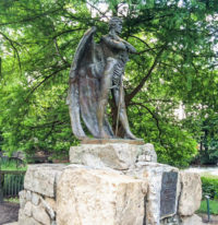 “Build a museum around it. Stop erasing our shameful past and start putting it in context.” [Memebag, commenting on Downtown’s Naked Confederate Birdman Unflapped By Renamings] Photo of the Spirit of the Confederacy statue in Sam Houston Park: Gabrielle Banks

TYPHOON TEXAS BOUNCES BACK FROM CHRISTIAN YOUTH LOCK-IN DISASTER 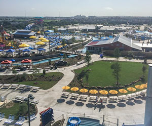 Dennis Spellman has details on the chaotic scene that forced Katy’s Typhoon Texas waterpark, barely 2 weeks off of its mid-flood Memorial Day weekend opening, to shut down just 2 hours into an overnight youth lock-in sponsored by local Christian radio station KSBJ’s parent company. Spellman writes that Friday’s event quickly “turned into an out-of-control melee” that led to the park removing the group in the middle of the night; in addition to reports of violence and drug use among the 5,000 estimated attendees, witnesses tell Spellman that the teens disrupted the scheduled musical performances by throwing water at sound equipment, and rioted in the park’s pools before being ejected by police around 1:30am. The company says park staff worked through the night to clean up and was open by Saturday morning as regularly scheduled. [Covering Katy; previously on Swamplot] Aerial photo of Typhoon Texas at 555 Katy Fort Bend Rd.: Typhoon Texas

WHY THAT ONE HOME IN THE BRAZOS FLOOD ZONE DIDN’T FLOOD Meanwhile, in Abbeville: The giant water-filled tubes of California-based AquaDam are getting some love from a homeowner with property near last week’s mandatory evacuation zone south of Houston. Upon hearing the Brazos River Authority’s flood predictions, Randy Wagner says he drove to the company’s Louisiana headquarters to pick up the 400-ft.-long structure, and deployed it around his house in Rosharon: “I was the crazy guy,” Wagner told KHOU. “Everybody was kinda going by, laughing at me. But today they are really impressed . . . †The dams are marketed most heavily for construction purposes, but also as a replacement for sandbag barricades in flood situations. Notable past deployments include the Ft. Calhoun Nuclear Generating Station in Blair, Nebraska where the dams successfully kept out 2 ft. of water from the nuclear plant during flooding in 2011 — until the AquaDam was accidentally popped. [KHOU, New York Times]
B TEAM WANTS TO SEND THE GRAND PARKWAY WHERE THEY WEREN’T ALLOWED TO GO 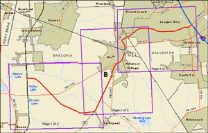 July 11th is the last day to make on-the-record comments about the route the Grand Parkway planners want to take from 288 to I-45 (known as Segment B of the 170-mile outer-outer loop). The finalized study documents published last week mention that proposed right-of-way runs across about 55 acres of wetlands — though that number isn’t precise: the document also mentions that the study authors couldn’t get permission to enter properties along 70 percent of the route, so the group had to use aerial photos to estimate. TxDOT’s desired route appears to hook in with SH288 at the intersection of CR 60 and follow the Brunner Ditch and South Texas Water Company canals southwest most of the way to SH35; from there it would swing back northeast just past Alvin, then eastward to hit I-45 where FM 646 does. [Previously on Swamplot]

COMMENT OF THE DAY: A FINAL DESPERATE CRY FOR DEMOLITION PARITY IN THE HEIGHTS 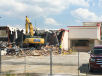 “The smashing has begun! Heavy machinery is on site, and the bricks are crumbling down. Where are the Friends of Heights Fiesta? Aren’t these bricks special enough to be saved???” [North Heights, commenting on Former Fiesta Site Preps for Teardown as Heights Dry Zone Petitioners Circle] Photo of demolition at 2300 N. Shepherd: Steven Byrne

GROUP FORMS TO CLEAN UP THE UPPER SAN JACINTO BEFORE IT GETS AS BAD AS BRAYS, BUFFALO, SIMS BAYOUS 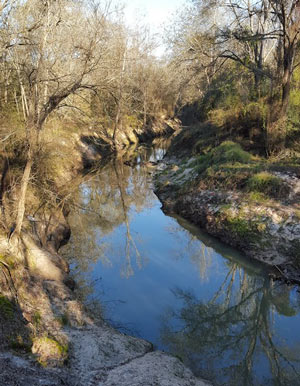 The West Fork of the San Jacinto River (implicated in much of the latest flooding between The Woodlands and Conroe) is in a bacterial “sweet spot”, environmental planner Justin Bower tells Matthew Tresaugue in the Houston Chronicle this week  — more contaminated than is acceptable, Bower says, “but not so much that we can’t do anything about it.” Tresaugue writes that E. coli levels have been trending upward since 2002, in some cases running as high as 10,000 colonies per 100 milliters of water (around 80 times higher than the 126-colony limit recommended by the state of Texas). The river’s water quality problems are multifaceted, but generally boil down to increased development in the watershed causing increased runoff that carries more junk — from human and animals waste to sediment from a nearby gravel mining operation — into the river and ultimately the Lake Houston reservoir (from which the city pulls drinking water). The newly formed West Fork Watershed Partnership has no definite plan yet (other than to work with area stakeholders to develop a plan). But Lisa Gonzalez (VP of the Houston Area Research Council) notes to Tresaugue that not doing anything could allow the West Fork’s water problems to get as bad as those of other major urban waterways in Houston. [Houston Chronicle; previously on Swamplot] Photo of West Fork of the San Jacinto: West Fork Watershed Partnership

HEIGHTS DRY ZONE SIGNATURE GATHERERS RETURN FROM THE HUNT VICTORIOUS  Reports comes from both NextDoor and The Heights Life blog that the H-E-B-backed Houston Heights Beverage Coalition has collected the signatures it needs to trigger a local election over legalizing carry-out beer and wine sales in the Heights dry zone. The petition was officially issued in mid-May, at which point the 60-day collection clock started ticking; the group claimed they needed 1,500 signatures to meet the required threshold of 35 percent of the population living in the zone. [Previously on Swamplot] Photo of TABC regional headquarters at 427 W. 20th St.: LoopNet

COMMENT OF THE DAY: THE PROOF IS IN THE PERMITTING  “You don’t need to read a university study to know the Houston housing market is going through a downturn. You don’t even have to look at HAR. To gauge the health of the Houston real estate market, you only have to look at the Daily Demolition Report: only 2 residential permits today; only 1 yesterday. Crisis!” [Angostura, commenting on Move-In Day Approaches for New Phillips 66 HQ; Montrose’s Crowded Mexican Restaurant Scene] Illustration: Lulu

THE ESTIMATED PRICETAG ON A STOP TO HOUSTON FLOODING 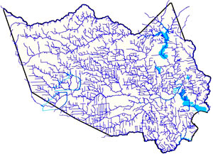 Amid the latest round of area flooding last week, Dylan Baddour traces the roots of Houston’s massive publicly funded drainage projects, which have brought the total length of Harris County waterways up to 2,500 miles (many of those channels widened, lined with concrete, or dug from scratch). Baddour also talks with current county flood control district director Mike Talbott about what it would take to expand and refine the city’s outdated flood infrastructure (which is often locked into place by close surrounding development) up to modern expectations — namely, that the flow of water over land that would otherwise be totally submerged should be totally controlled. Baddour writes that Talbot “has a simple solution: allocate $26 billion, more than a fifth of the state’s 2015 budget, mostly to buy property adjacent to the waterways, bulldoze and expand the canals.” Rice University ecologist Ron Sass tells Baddour he’s surprised the city hasn’t been tearing down old houses to build new bayou channels: “We build freeways. I would think that a bayou would be as important to our infrastructure as a freeway.” [Houston Chronicle] Map of Harris County waterways: Harris County Flood Control District

COMMENT OF THE DAY: WHY FLOOD CONTROL ENTHUSIASTS KEEP EYEING PREVIOUSLY PAVED LOTS  “This is a standard practice: to elevate [existing] commercial properties so they will drain off the property. It is very easy to do. The concern is that the city of Houston does not require new properties on old lots to detain water on the lot.  . . . Elevated commercial properties that do not mitigate acre-foot-for-acre-foot will lead to water running off and flooding adjacent properties. It is a simple concept, but developer propaganda is strong. The most common myth promulgated by the developers is that if something was already concrete then a new property need not mitigate run-off. The fact is, any time a new development is built that does not mitigate run-off, it will force water onto its neighbor. [Flooding, commenting on Former Fiesta Site Preps for Teardown as Heights Dry Zone Petitioners Circle] Illustration: Lulu

FOR SALE: CECIL’S PUB ON W. GRAY 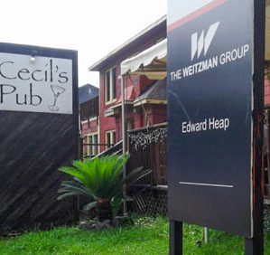 All 6,250 sq.ft. of Cecil’s Pub are now up for sale, after some 31 years of operation.  A reader reports that the bar is still open for now, though an information sign from The Weitzman Group is up out front of the building at 600 W. Gray. Weitzman has a leasing flier up for the property as well; the bar sits on just under half an acre of land east of PJ’s Sports Bar (at the corner with Stanford St.) and north of Skinny Rita’s Cantina (last occupied by Eleven:Eleven); just down the street are the North Montrose branch of Barnaby’s Cafe and the planned site of the West Gray Plaza strip center. Photo: Swamplot inbox
North Montrose Signs of Change

RICE UNIVERSITY’S U-TURN AWAY FROM A MODERNIST OPERA HOUSE 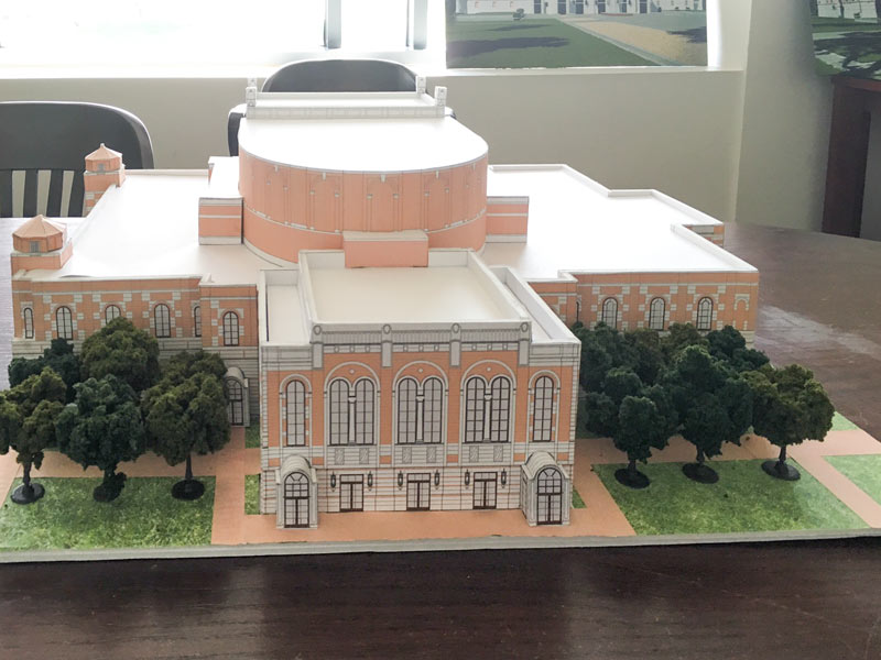 A recent Facebook post by architect Allan Greenberg appears to confirm his firm’s involvement with the Rice University opera house project, of which possible renderings and a model recently surfaced in another building on campus. The choice of Greenberg, a self-described classical architect who designed the university’s Humanities Building, represents a major reversal of ideology from the previously announced selection of Diller Scofidio + Renfro (designers of part of New York’s High Line, who once created a building shrouded perpetually in fog). The selection of DS+R was announced in March of 2014; Greenberg had begun to publicly mention involvement with the project by this past December. [Previously on Swamplot] Photo of Rice University opera house design model: Swamplot inbox

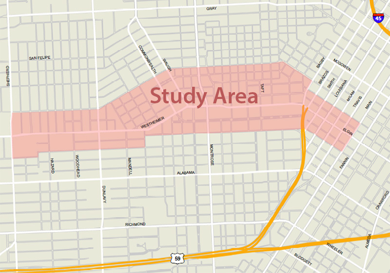
YOUR CHANCE TO TALK ABOUT LOWER WESTHEIMER BEFORE THE REDO PLANS GET DRAWN UP  A meeting is set for 6pm Monday for anyone with opinions about what the Montrose section of Westheimer Rd. should or shouldn’t look like, as the ReBuild Houston folks turns an eye toward the corridor. Traffic consultant Geoff Carleton tells Dug Begley that bike infrastructure is low on the project wishlist, as bike lanes are already planned for W. Alabama. Carleton says that widening the road, which Metro’s larger buses can’t currently fit down, will be a hard enough sell already, adding that current priorities are for Westheimer to be both “walkable and transit-friendly.” A list of links to previous studies of the area’s transit situation is included on the city’s meeting info page. [Houston Chronicle] Image of Lower Westheimer study area: City of Houston

DEPT. OF PUBLIC SAFETY TO UT: PLEASE DITCH THE PHOTOS OF FLOOD-RELATED CHEMICAL SPILLS WE DIDN’T NOTICE Meanwhile, in Austin: Texas Department of Public Safety officials have recently asked the University of Texas to remove an online collection of aerial photos taken by the Texas Civil Air Patrol during major flooding events, Marty Schladen writes in this weekend’s El Paso Times. The request comes after the Times reported earlier this spring on what appeared to be photos in the database showing a number of chemical spills not captured in any other state monitoring records, including spills along the Trinity river north of Galveston Bay; other photo sets previously on the site reportedly included shots of Houston sewage treatment plants being flooded on Tax Day, as well as possible unreported spills along the Colorado, Sabine, Red, and Pecos rivers since 2014. DPS Spokesman Tom Vinger tells the Times that pulling the photos is a matter of protecting privacy — “for example, there could be pictures of deceased individuals prior to family members being appropriately notified first,” says Vinger. Non-emergency-responders can still ask for the photos via Public Information Act request. [El Paso Times]