COMMENT OF THE DAY: THAT HIGH HORSE WON’T KEEP YOUR FLOORS DRY  “Wonder how many areas will sue to get out of the high risk zones, only to get flooded years later, have no insurance, and cry foul. Note to those who are able to sue or survey themselves out of a flood zone… buy the insurance anyway! If you are [put] in a high risk zone, right or wrong, you are close enough to warrant the protection.” [Rex, commenting on A Quick Tour of Spots Where FEMA Will Expand Its Flood Hazard Zone In January] Illustration: Lulu
Tag: Flooding
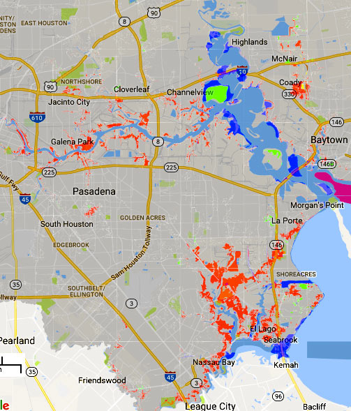
The areas in red above mark some of the new additions to the legally-gotta-buy-flood-insurance zones on FEMA’s recently revised flood maps. The agency’s interactive online viewer lets you mix-and-match a few data sets for Harris County (as well as Galveston, Fort Bend, and Wharton), compare the old mapped flood zone boundaries to proposed new ones, or look only at what would change — a FEMA spokesperson told Houston Public Media that about 8,000 properties have been added to the list in Harris County, while only about 400 were dropped.
Those acid-green highlights are areas that have been removed from the special flood hazard zone by the updated map (while blue shows areas that have just changed floodplain classification some other way. Bits of brown and yellow in other areas of the map show places added or removed (respectively) from the floodway. The updates above to the mandatory flood insurance zone (legally called the Special Flood Hazard Area) are set to go into effect in January, as shown above. Buffalo Bayou and its tributaries are pretty marked up:
THE NEXT BIG HURRICANE REBUILD WILL GO MUCH FASTER IF YOU START ON IT NOW Meanwhile, in Brownsville: Housing advocates in Dolly-battered South Texas have since developed a disaster response program optimistically called Rapido; new legislation (similar to a bill that failed in the last Texas legislative session) is in the works to make Rapido-style “precovery” response a statewide standard. The program involves the fast deployment of permanent 1-room housing “cores” that can be quickly assembled by local workers and then added onto later; the bigger component of the program, Leah Binkovitz writes this week, is extensive pre-planning initiatives in potential disaster areas, instead of what housing advocate John Henneberger calls “reinventing disaster recovery from a blank sheet of paper every time there’s a disaster.†Binkovitz writes that the program calls for preemptive outreach “to determine what kind of disaster housing would be most appropriate, who could build it, who would be eligible to receive it and what resources would be available. That conversation should even include whether folks want to rebuild in vulnerable neighborhoods and how to offer alternatives.” [Urban Edge; previously on Swamplot]
STOP TRYING TO FIX BUFFALO BAYOU, SAYS SAVE BUFFALO BAYOU  The waterway enthusiasts at Save Buffalo Bayou just issued their report on their recent tours of the waterway, with an eye toward how the scene has changed in the wake of the Tax Day flooding and the extended high flows from the try-not-to-make-things-worse paced drainage of the Addicks and Barker reservoirs. The photo above, taken during the organization’s scouting, shows an area of the bayou where the river channel dug through a curve and moved over, such that some landmarks previously on the north bank are now on the south side. The authors take issue with a number of current and proposed plans to keep the bayou’s banks in place, and suggest that the best way to end up with a relatively stable channel is to step back and let geology do the job: “When the bayou’s banks slump or collapse, the brush and fallen trees left in place collect sediment during subsequent high waters, gradually rebuilding naturally reinforced banks. These new nature-built banks are better able to withstand subsequent floods as well as the more powerful flows being released from the dams . . . The bayou itself then reseeds these and other sandy areas with the proper succession of plants that first colonize then stabilize the sediment, turning sand into soil, preparing the way for seedlings of trees. It’s part of the natural function of riverine flooding that we rarely have opportunity to observe, especially in the middle of a city where we have dug up and covered in concrete most of our bayous and streams.” [Save Buffalo Bayou; previously on Swamplot] Photo: Save Buffalo Bayou
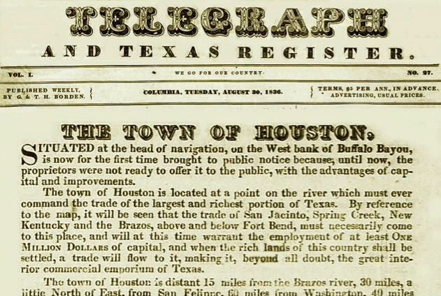
It’s that time again — Houston’s birthday celebration, observed traditionally on the anniversary of the publication of the Allen brothers’ newspaper ads offering land for sale in the area in 1836. Among the more eyebrow-worthy claims put forward by the founders: that the “beautifully-elevated” area (depicted nestled amid a clutch of towering hills) was already the site of regular steamboat traffic (the Laura wouldn’t make the first steamboat run up the sandy twists of Buffalo Bayou to Allen’s Landing until the following year), and that the area “[enjoys] the sea breeze in all its freshness” and is “well-watered” (that part, at least, is likely undisputed).
The ad text also claims that “Nature appears to have designated this place for the future seat of Government,” though Lisa Gray suggests this morning that a few well-timed gifts to members of the newly-minted Texas Legislature may have been responsible as well. Gray writes that the city hosted the Texas government from 1837 until the legislators, tired of the heat and mosquitoes, voted to move elsewhere in 1839.
Here’s the ad in its entirety, as it appeared 180 years ago today in the Telegraph and Texas Register:
COMMENT OF THE DAY: START SAVING WATER EARLY FOR LOWER FLOODING RETURNS  “Like I said before, the real solution is engineering and good land cover practices upstream. By the time the flow gets to [the Bay], there is no real answer. Just like your child and your 401k, the earlier in the life cycle you contribute, the more impactful that contribution will be further down.” [Rex, commenting on Comment of the Day: All Houston Floodwater Backs Up in the Same Drain] Illustration: Lulu
COMMENT OF THE DAY: ALL HOUSTON FLOODWATER BACKS UP IN THE SAME DRAIN  “Every editorial and study which I have seen fails to consider the plug in the bath tub. Every drop of rainwater in the metro area ultimately finds its way to Galveston Bay (and then the Gulf of Mexico). During the major flood events this spring, the tide was exceptionally high and there was a strong steady wind from the southeast. The waters of Clear Creek and the San Jacinto River were nearly three feet above normal before the first drops fell. There was no outlet for the rain and it backed up and up and up. Nothing had changed for this flood except the wind and the tide did not work in favor of Houston.” [Jardinero1, commenting on Cross-County Accounting for the Houston Flooding Puzzle] Illustration: Lulu
CROSS-COUNTY ACCOUNTING FOR THE HOUSTON FLOODING PUZZLE 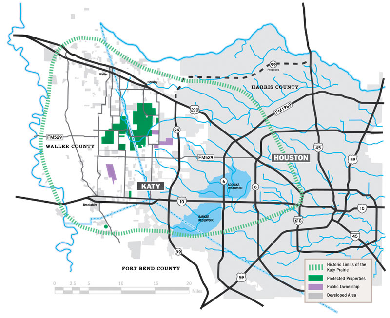 Kim McGuire checks in on the local hardscape in Friday’s Chronicle, as part the latest piece in a series examining roots of the area’s chronic flooding habit. The Houston Area Research Council tells McGuire that roughly 337,000 out of 1.1 million acres of Harris county were covered by surfaces impervious to rainfall runoff as of 2011 (the most recent year of data); meanwhile, softer surrounding counties (including the ones hosting much of the much-reduced Katy Prairie) have been racing to catch up with much higher rates of added hard area. McGuire notes that while developers are generally required to add detention basins to projects that increase the rate of runoff from their land, this does not actually require them to “eliminate runoff from their projects.” Mark Mooney, an engineer for Montgomery County, also tells McGuire that despite the regulatory scrutiny on any individual project with respect to keeping a balance betweeen added runoff and added detention, its still “clear [that] the way water moves through our county has changed. It’s all part of a massive puzzle everyone is trying to sort out.“ [Houston Chronicle; previously on Swamplot] Map of Houston drainage and current/historic Katy Prairie extent: Katy Prairie Conservancy
COMMENT OF THE DAY: STRAIGHTENING OUT THE CONCRETE-LINED BAYOU PARADOX  “While I am no run-off-water-channeling expert, I am under the impression that tossing out the concrete is not just for appearances. The concrete ditch moves the water faster than the natural channel, and can [thereby] actually aggravate flooding rather than cure it. Returning to the natural channel structure may mitigate flooding.” [Al, commenting on Might White Oak Bayou Ditch Its Concrete?] Photo of White Oak Bayou channel: Swamplot inbox
MIGHT WHITE OAK BAYOU DITCH ITS CONCRETE? 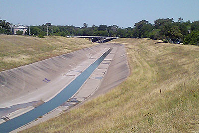 The Harris County Flood Control District is looking at removing the concrete lining from sections of the White Oak Bayou channel, writes Mihir Zaveri. The agency is conducting a study on redeveloping parts of the waterway along with the Memorial-Heights Redevelopment Authority (a.k.a. TIRZ 5); any future projects to come from the study would be within the TIRZ 5 boundaries, along sections of White Oak between roughly N. 610 and Houston St. Zaveri writes that the push “in part reflects the idea that waterways where flooding must be controlled don’t have to be eyesores, and in fact can become more natural settings for residents to bike, walk and gather. It follows decades-old conversations about how to shape waterways in a flood-prone region like Houston, where the rapidly growing population has increasingly come to demand improvements in quality of life.” With respect to balancing aesthetics against effective flood control practices, TIRZ 5 chairwoman Ann Lents tells Zaveri that “pretty is never going to trump functional . . . But because of new techniques, if we can find a way to do both better, I think that will be a great thing.” [Houston Chronicle] Photo of White Oak Bayou: Swamplot inbox
TEXAS SUPREME COURT: FLOOD CONTROL AGENCY DIDN’T CAUSE WHITE OAK FLOODING BY NOT CONTROLLING IT 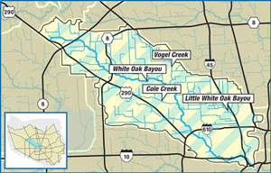 On Friday the state’s highest court reversed course on a class-action lawsuit filed by White Oak Bayou-adjacent homeowners flooded by turn-of-the-century storms including Allison, writes Mike Morris. Gabrielle Banks previously reported that some 200-plus families living along the upper reaches of bayou between Jersey Village and Houston Rosslyn Rd. had been asking for a collective $85 million or so to make up for flood damage and property devaluation they say was caused by the agency not completing some planned detention projects that haven’t gotten expected federal funding. The court decided last fall that the plaintiff’s case was strong enough to warrant a juried trial — at which point more than a dozen city and state government bodies filed letters asking it to please reconsider. Friday’s ruling came down in favor of the flood control agency, though the 4 dissenting judges wrote that the organization knew approved upstream development would lead to flooding without the planned projects, and therefore caused flooding by not requiring enough mitigation. The ruling could impact the similar lawsuit recently filed by a group of Memorial-area homeowners against the city and TIRZ 17, though in that case the group Residents Against Flooding is asking for flood control-related action rather than money. [Houston Chronicle; previously on Swamplot] Map of White Oak Bayou watershed: Harris County Flood Control District
WHY THAT ONE HOME IN THE BRAZOS FLOOD ZONE DIDN’T FLOOD Meanwhile, in Abbeville: The giant water-filled tubes of California-based AquaDam are getting some love from a homeowner with property near last week’s mandatory evacuation zone south of Houston. Upon hearing the Brazos River Authority’s flood predictions, Randy Wagner says he drove to the company’s Louisiana headquarters to pick up the 400-ft.-long structure, and deployed it around his house in Rosharon: “I was the crazy guy,” Wagner told KHOU. “Everybody was kinda going by, laughing at me. But today they are really impressed . . . †The dams are marketed most heavily for construction purposes, but also as a replacement for sandbag barricades in flood situations. Notable past deployments include the Ft. Calhoun Nuclear Generating Station in Blair, Nebraska where the dams successfully kept out 2 ft. of water from the nuclear plant during flooding in 2011 — until the AquaDam was accidentally popped. [KHOU, New York Times]
THE ESTIMATED PRICETAG ON A STOP TO HOUSTON FLOODING 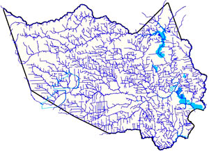 Amid the latest round of area flooding last week, Dylan Baddour traces the roots of Houston’s massive publicly funded drainage projects, which have brought the total length of Harris County waterways up to 2,500 miles (many of those channels widened, lined with concrete, or dug from scratch). Baddour also talks with current county flood control district director Mike Talbott about what it would take to expand and refine the city’s outdated flood infrastructure (which is often locked into place by close surrounding development) up to modern expectations — namely, that the flow of water over land that would otherwise be totally submerged should be totally controlled. Baddour writes that Talbot “has a simple solution: allocate $26 billion, more than a fifth of the state’s 2015 budget, mostly to buy property adjacent to the waterways, bulldoze and expand the canals.” Rice University ecologist Ron Sass tells Baddour he’s surprised the city hasn’t been tearing down old houses to build new bayou channels: “We build freeways. I would think that a bayou would be as important to our infrastructure as a freeway.” [Houston Chronicle] Map of Harris County waterways: Harris County Flood Control District
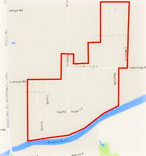 Residents of the Rio Brazos area near Cumings Rd. north of Rosharon are being advised as of this afternoon to boil their tap water until further notice, while the Fort Bend County Fresh Water Supply District 2 sorts out possible problems stemming from a flood-related loss of water pressure in the network. (The map included here has been added to the Fort Bend County emergency office’s Facebook page following a brief online outpouring of confusion as to what neighborhoods the warning was actually targeting.)
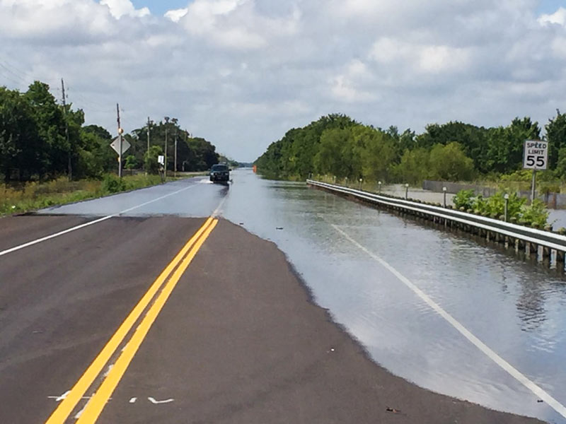
Meanwhile, TXDOT is still listing dozens of miles of roadways as covered by to high water as of this morning, with more closures expected as Brazos floodwaters drain southwest toward Angleton and Freeport. Here’s Brazoria County’s latest worst case scenario potential floodmap, with the county’s mandatory evacuation zones now stretching across more than 15 miles from roughly Brazos Bend State Park to the outskirts of Angleton:
COMMENT OF THE DAY: WHY FLOOD CONTROL ENTHUSIASTS KEEP EYEING PREVIOUSLY PAVED LOTS  “This is a standard practice: to elevate [existing] commercial properties so they will drain off the property. It is very easy to do. The concern is that the city of Houston does not require new properties on old lots to detain water on the lot.  . . . Elevated commercial properties that do not mitigate acre-foot-for-acre-foot will lead to water running off and flooding adjacent properties. It is a simple concept, but developer propaganda is strong. The most common myth promulgated by the developers is that if something was already concrete then a new property need not mitigate run-off. The fact is, any time a new development is built that does not mitigate run-off, it will force water onto its neighbor. [Flooding, commenting on Former Fiesta Site Preps for Teardown as Heights Dry Zone Petitioners Circle] Illustration: Lulu

