05/12/17 1:30pm


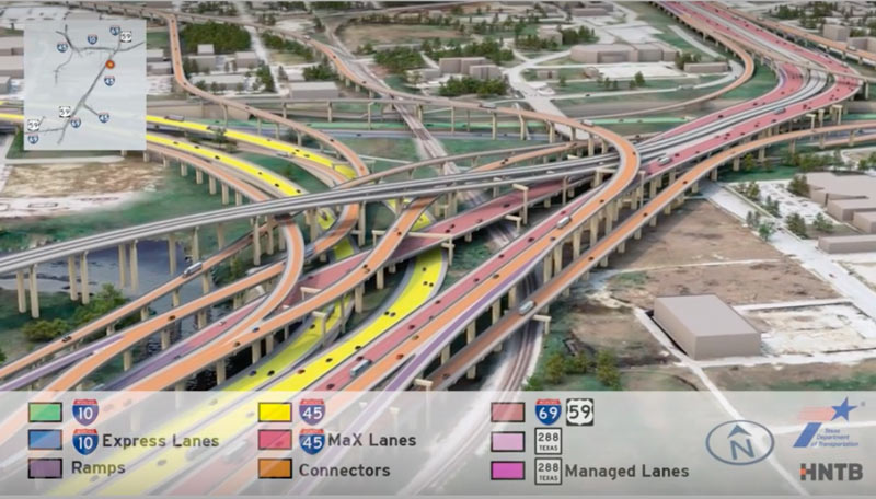
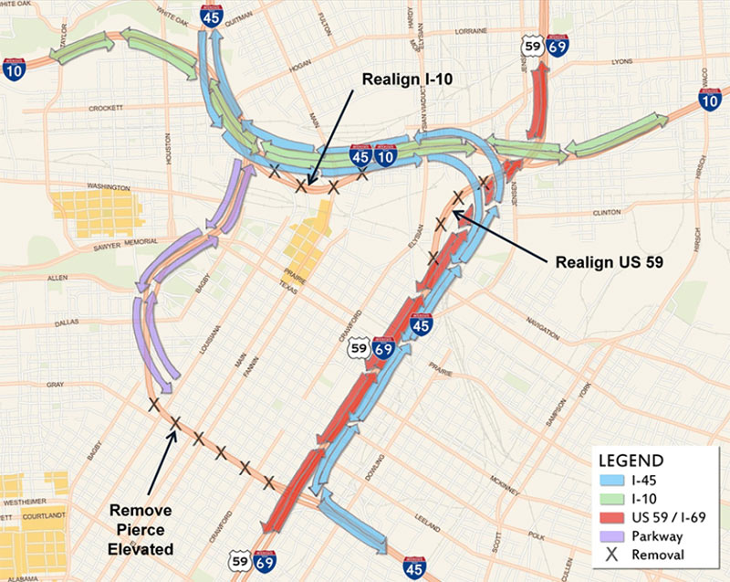
Having trouble sifting through some of the massive freeway jumbles in the latest plans for that major I-45 reroute between Downtown and the Beltway? This new video (making the rounds this month as TxDOT hosts a set of public meetings to chat about the project) may or may not help you out. The 10-minute animation shows off what the project plans look like in multicolored, car-spangled 3D action, dragging viewers slowly along the entire project route from Spur 521 up to Beltway 8.

The project plans pull 45 over to the east side of Downtown, to line up alongside US 59 and dive underground behind the George R. Brown convention center. Various flavors of new express lanes, managed lanes, managed express lanes, and connectors weave into and out of a massive new 45-59-10 junction as shown above, all labeled by color. Here’s a clip of the above video showing just that section of the animation:

CONTINUE READING THIS STORY

Painted By Number
02/27/17 5:00pm

TXDOT TO PIERCE ELEVATED: YOUR YEARS ARE NUMBERED, PROBABLY pierce-street-45-downtownPending a vote next month by the Texas Transportation Committee, some early-stage projects connected to TxDOT’s plan to reroute I-45 and the whole downtown freeway exchange system could be getting started a few years sooner than TxDOT officials initially thought they would, Dug Begley writes in the Chronicle. (Those early stages include the reworking of the bottleneck on northbound US-59 where Spur 527 now peels off 2 of the freeway’s lanes just before SH 288 merges into the mix.) The first few projects “are incremental compared to the overall plan,” writes Begley, but “officials say [the projects] are important and send the clear message: The I-45 freeway is relocating and the elevated portion along Pierce will be abandoned and maybe demolished within the next dozen years. . . .Work on revamping the freeway intersections is slated for late 2020 or early 2021.” [Houston Chronicle; previously on Swamplot] Photo of Pierce Elevated: Russell Hancock

01/31/17 11:30am

7006 I-45 South at Woodridge, Gulfgate, Houston, 77087

7006 I-45 South at Woodridge, Gulfgate, Houston, 77087 Vintage roadside attraction photographer Molly Block sends in the fresh shot above of the empty triple post that previously held up the neon beacon of Gulfgate all-night diner Dot Coffee Shop (along with a previous portrait of the sign itself, circa 2013). Block snapped the picture of the bare poles over the weekend; an employee tells Swamplot this morning that both the Dot sign and the sign for also-Pappas-owned Pappas Bar-B-Q next door had to be temporarily taken down out of the way of that planned reworking of the I-45-Loop-610 intersection. The project will add another pair of direct connectors between the 2 highways, and retool the southbound I-45 frontage road, which runs along the edge of the restaurants’ parking lots (as shown in the TxDOT schematics below):

CONTINUE READING THIS STORY

Gulfgate Rearrangements
08/30/16 5:30pm

Billboards and signs near Gulfgate, Houston, 77087

In the wake of a multi-year legal tiff between TxDOT and an Austin-based real estate company over a freestanding Ron Paul 2012 sign outside of an erotica shop on Hwy. 71, a district appeals court has just struck down central parts of the Texas Highway Beautification Act, Dug Begley reports today. The ruling may have eventual implications for city makeover enthusiast Scenic Houston’s long-term de-billboarding quest, and comes right on the heels of the announcement last week that an additional 13 signs around Houston would be coming down.

CONTINUE READING THIS STORY

Signs of the Times
06/09/16 5:15pm

B TEAM WANTS TO SEND THE GRAND PARKWAY WHERE THEY WEREN’T ALLOWED TO GO Proposed Grand Parkway Segment B
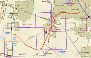
July 11th is the last day to make on-the-record comments about the route the Grand Parkway planners want to take from 288 to I-45 (known as Segment B of the 170-mile outer-outer loop). The finalized study documents published last week mention that proposed right-of-way runs across about 55 acres of wetlands — though that number isn’t precise: the document also mentions that the study authors couldn’t get permission to enter properties along 70 percent of the route, so the group had to use aerial photos to estimate. TxDOT’s desired route appears to hook in with SH288 at the intersection of CR 60 and follow the Brunner Ditch and South Texas Water Company canals southwest most of the way to SH35; from there it would swing back northeast just past Alvin, then eastward to hit I-45 where FM 646 does. [Previously on Swamplot]

05/01/15 11:15am

If you were dazzled by the wide swaths of concrete laneage and complicated color-coded spaghetti interchange entanglements in the TxDOT renderings released last week — but had trouble comprehending the massive scale of the proposed reroute of I-45 around Downtown — you’ll want to try this second go at it. The state transportation agency has now produced a video version of its freeway-rewrapping proposal, complete with tiny little animated cars and trucks moving along 3-D representations of those new wide surfaces. It’s so mesmerizing, many viewers may not even notice what happened to the Pierce Elevated.

Video: TxDOT, via Houston Chronicle

North Freeway Downtown Rewrap
04/23/15 5:30pm

Proposed Changes to I-45, I-10, and I-69, Houston

There’s so much to talk about and gawk at in the latest “proposed recommended alternatives” for reshaping I-45 now being shopped around by TxDOT and a host of freeway-happy consultants — enough for a fourth round of public meetings scheduled for tonight and next week, plus hours of extra-curricular speculation. The plans encompass dramatic changes to the North Freeway all the way from Beltway 8 to a new split adjacent to the Third Ward, including eye-opening widenings, all sorts of exciting tunnels and high-flying overpasses, a slew of spaghetti-like interchanges, and — the pièce de résistance — the wholesale give-up of I-45’s current L-shaped wrap around Downtown, including the Pierce Elevated.

These 5 images from our highway overlords’ exciting imagined future sum it up best:

1. The X-ing-out of the Pierce Elevated (diagrammed above). If the elevated portion of I-45 along the path of Pierce St. goes away, how will anyone be able to tell where Downtown ends and Midtown begins? Don’t worry, a few proposals are being shopped around to turn a de-automobiled structure into a High Line—like public park or bikeway. (Though much bigger, ′cuz Houston.)

CONTINUE READING THIS STORY

Freeway Frenzy!
03/25/15 12:15pm

Interstate 69 Sign North of Hernando, Mississippi

Snickers and awkward guffaws are likely to be heard all the way from the Northside to Afton Oaks next week, once state transportation officials sign off on the addition of another name to the 11.9-mile segment of State Hwy. 59 within Houston’s Inner Loop: Interstate Highway 69. New signs announcing I-69 proudly to the world will subsequently be erected along in-town stretches of the freeway, where they’ll likely be targeted for pointed display in neighborhood bars, strip clubs, or dorm rooms.

Once complete, I-69 will connect the highway’s head at the Canadian border in Port Huron, Michigan, to its tail along the Mexican border, where it will spread into 3 separate paths to Laredo, McAllen, and Brownsville. Planners hope the availability of a smooth, continuous ride from north to south and back again along the eventual federally sanctioned route (sometimes called the NAFTA Superhighway) will stimulate and ease trade among the entwined nations.

CONTINUE READING THIS STORY

Making the Link
11/03/14 1:30pm

TXDOT LIKELY TO CUT FUNDING FOR WEST LOOP BUS LANES, SHIP MONEY SOUTH Proposed Dedicated Bus Lanes on Post Oak Blvd., Uptown, HoustonIn a move that could spell doom for the Post Oak Bus Rapid Transit project, TxDOT’s planning director said Thursday that his agency is now recommending it ax a $25 million commitment to expanding connecting bus service along the West Loop. The plan called for elevated bus lanes  running along 610 from Post Oak Blvd. to the Northwest Transit Center near the Katy Fwy. and 610. The agency now claims that the $25 million would be better spent on an improved Texas 288–Beltway 8 interchange. [The Highwayman, previously on Swamplot] Rendering: Uptown Houston   

03/31/14 10:30am

White Oak Bayou Hike and Bike Trail Along T.C. Jester at 610 Loop, Oak Forest, Houston

Here’s the news that’s “all the rage in Oak Forest,” according to a reader: TxDOT has reopened the segment of the hike-and-bike trail along White Oak Bayou that wends its way between between Ella Blvd. and 34th St. That stretch of asphalt had been closed in December 2011 for construction on the North Loop overpass at T.C. Jester. TxDOT is planning an official celebration of the reopening this coming Saturday, but it’s unclear whether the path, which lines the east side of the bayou, will have to be closed again at some point. “Please note that TxDOT has not completed the reconstruction of the bridges that support the feeder roads across the bayou,” reads a note on the Houston Bikeways Program Facebook page posted this morning. “We hope to get more details shortly.”

Photo of trail at E. T.C. Jester and Loop 610 North: Jim Mackey/White Oak Bayou Association

610 Underpass
06/12/13 12:05pm

The 11-year run is coming to an end: According to a letter signed by franchise operator Charles Gibson and posted in the store’s window, June 14 will be the last day for this Webster Chick-Fil-A. The letter explains that TxDOT has purchased the property with plans to expand I-45. Across that freeway from the Baybrook Mall, this Chick-Fil-A is the northernmost chain of that cluster of ’em accessible via the feeder from Bay Area Blvd.

Photo: Panoramio user MrQuick

03/05/13 3:30pm

Note: A TxDOT spokesperson has confirmed that the total cost of the project is $1.3 billion. Story updated below.

This map shows where commuters would get in and out of the toll lanes that TxDOT says it will build in the grassy median of Texas 288 — part of a project it’s proposing to help deal with Med Center congestion and development southwest of town by widening 26 miles of the highway between U.S. 59 and County Road 60. Several new overpasses at intersections and upgraded connections to the Loop and Beltway 8 are also included in the project, which TxDOT says will cost about $1.38 million $1.3 billion. The full extent of the project will be rolled out tonight at a public hearing in Houston and again on Thursday in Pearland.

Map: TxDOT

01/04/13 10:28am

Last month, Cite magazine editor Raj Mankad hiked 8 miles through the Katy Prairie to see the prehistoric human remains found during the construction of Grand Parkway’s Segment E for himself. He brought back a few photos and an essayist’s-eye-view of the archaeological saga:

It appeared as if TxDOT had aimed the 15-mile-long highway segment directly at the burial ground. The highway was suspended, figuratively and physically, like an unintentional monument honoring the burial grounds, like Texas was trying to tell anyone in an airplane or spaceship to LOOK HERE. . . . What I saw were several pieces of plywood, propped up on five-gallon paint buckets, covering what I presume to be the human remains and the tools, buffalo teeth, and other objects found with them. The plywood was weighted down with rocks. . . . To my amateur eyes, the excavation looked makeshift and tenuous, not systematic or professional.

Photos: Brett Sillers

11/11/11 2:44pm

THE MAN WHO RESURRECTED THE GRAND PARKWAY As recently as the beginning of this year, 2 northwestern segments of the proposed fourth ring road around Houston were considered by many to be stalled projects — remnants, even, of an outdated dream to project sprawling, suburban-style development ever outward from the city. But by September, construction on the 15.2-mile Katy Prairie paving program known as Segment E of the Grand Parkway had magically begun; further north, Grand Parkway’s Segment F — the portion that would connect ExxonMobil’s proposed campus in Spring to western suburbs — now appears inevitable. How’d that happen? Reporter Angie Schmitt looks at the role of developer and TxDOT commissioner Ned Holmes in the startling turnaround, including the former banking executive’s remarkable ability to dig up a previously unnoticed $350 million deep in the books of the otherwise cash-starved state agency he oversees — in order to make the Grand Parkway happen. [StreetsBlog; previously on Swamplot] Photo of Rte. 99 ramp construction: Covering Katy

08/25/11 8:22am

Just how far down the road does the Texas Dept. of Transportation want to take its court battle with a Houston romance novelist, her publisher, and a bookstore? Yesterday a federal judge in Austin denied TxDOT’s request for a restraining order that would have required all 35,000 copies of a new book to be recalled from distributors and destroyed — and be given a new title. Christie Craig’s shirtless-hunk-filled novel, Don’t Mess with Texas, was released on Tuesday. TxDOT complained that the book used the agency’s trademarked slogan for a statewide anti-littering campaign as its title without permission. But under questioning, TxDOT’s attorneys had conceded that none of the trademark registrations for the phrase “Don’t Mess with Texas” specifically covers books. In his decision, Judge Sam Sparks found that point significant, and noted that the costs of recalling the book would likely be very high.

CONTINUE READING THIS STORY