ANY TAKERS FOR E-DOW? 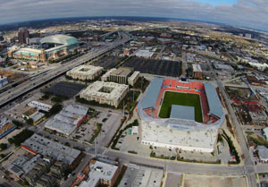 Reader and aspiring appellative linguist Bradley Rampp writes in seeking insight on “a serious question:Â How do you pronounce EaDo? I’ve always said E-dough. The Metrorail calls it E-dew.” Photo of East Downtown near EaDo/ Stadium Station on the Green Line: Russell Hancock
Sign up for the Newsletter

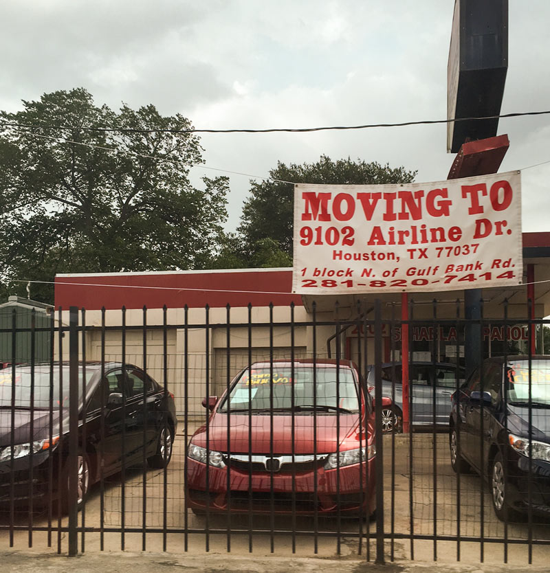
A reader’s drive-by shooting at the corner of N. Shepherd Dr. and W. 20th St. captured a few photos of Abel Motors, whose new signage announces a move to parts even further north. The dealership’s new location at 9102 Airline Dr. will put it just south of Halls Bayou at the intersection of Airline and Gulf Bank Rd. across from the Cathedral of St. Matthew. (and amid a suite of other car sales and auto repair operations up and down the street).
The N. Shepherd spot to be vacated sits catty-corner to the former car dealership property currently being redeveloped as a Mellow Mushroom-containing retail strip, and a block north of the Take 5 Oil Change getting into gear at the corner with 19th St. Here’s another shot of the corner, looking north across 20th toward the ex-Fiesta a few blocks up the road:
Peeling Out

ENTIRE LOUISIANA ISLAND POPULATION TO BE TRANSPLANTED WITH FEDERAL ‘CLIMATE RESILIENCE’ FUNDS Meanwhile, in Isle de Jean Charles: Planning is currently in the works to resettle roughly 60 people following the gradual disappearance of more than 90 percent of their island due to a combination of industrial and climate change factors, including sea level rise, subsidence, erosion along manmade channels, and the blocking of wetland-rebuilding sediments by levees and other flood-control structures. The community, mostly members of the Biloxi-Chitimacha-Chocktaw tribe, is frequently blocked by flooding from jobs and schools on the mainland. In January, the first-ever  federal National Disaster Resilience Competition awarded $92 million dollars to the state of Louisiana, which has lost nearly 1,900 square miles of coastal land since the 1930s. Some of the money will go to the Isle de Jean Charles move, and the rest will seed a state fund to help finance other coastal “resilience” projects anticipated in the coming years. A total of $1 billion dollars for similar projects was awarded through the competition to 13 applicants (8 states and 5 communities); the city of New Orleans received a separate grant for $141 million. [New York Times, U.S. Dept. of Housing and Urban Development]
COMMENT OF THE DAY: TRACING THE ROOTS OF THE HOUSTON GRID  “The Republic of Texas in 1837 created various categories of immigrants in order to assign land grants. The coastal regions and plots fronting major rivers were for the most part already claimed by settlers that had arrived under Mexican governance, so what was allocated for new settlers was primarily west and north of the coast and between rivers. Most of these grants were made in 640-acre (1-square-mile) increments (or double or half that). These were made as geometrically regular as possible given natural features. In the nearly-featureless prairies west of Houston and notably in the Katy Prairie, you had these perfect grids dominating much of the plat maps. Roads and fences were built to follow that pattern for obvious reasons. The legacy of this system has shaped policy ever since.” [TheNiche, commenting on Ring Around the Katy Prairie, and Other Orbital Highway Fun] Map of previously planned thoroughfare routes across Katy Prairie Conservancy preserve: Harris County Planning and Infrastructure Department


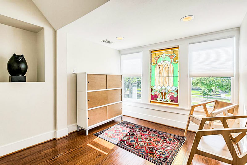
On the market as of 2 weeks ago: the home-slash-power-plant on the corner of Virginia and Colquitt streets, a block west of the now-rising Kirby Collection.  The listing claims the building is Houston’s first LEED-Platinum certified home (though others have since followed suit), and by Houston standards, Adams Architects took extreme measures to reduce the 1,900-sq.-ft. house’s dependence on city utilities networks.
Rooftop solar panels send excess energy to the power grid during the day, and a back-up battery system is in place in case the grid ever goes down. Tucked out of sight below the 3-bedroom structure are geothermal conduits which circulate water down to hotter strata 300 ft. deep, collecting energy to heat and cool the house. A 7,000-gallon cistern beneath the recycled-plastic deck also collects rainwater for use in the space.
Ready to peek inside?
Green Machine in Upper Kirby

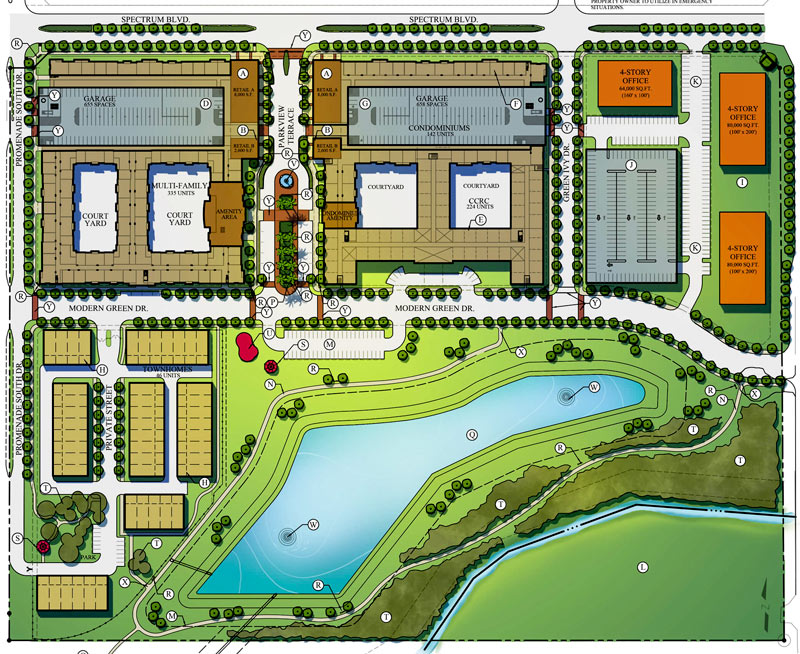
Ralph Bivins tells Swamplot that lots of dirt is being shoved around on the foreclosed former site of the WaterLights District project, west of 288 and just south of the Beltway where all those heads of former heads of state used to hang out. Pearland’s Ivy District is now being planted on the site instead: plans for the $300-million development include a multifamily complex, condos, a senior living community, townhomes, office buildings, and room for retail.
Part of the project’s funding will come from the EB-5 visa program, which allows wealthy foreigners and their immediate families to immigrate to the US in exchange for a necessary investment expected to create at least 10 jobs. Sueba USA and Beijing-owned American Modern Green are developing the site; American Modern’s parent company Modern Land of China has worked on projects in China (including Steve Holl’s twisty Linked Hybrid in Beijing) and Vancouver, but the Ivy District is its first US venture.
American Modern Green bought the land straddling the Harris-Brazoria county line back in late 2012 following the 2010 foreclosure. Here’s the breakdown of what will go where, per the current plans on the Ivy District’s website:
Planting in Pearland


- 2727 Kirby Dr., 19L [HAR]

A set of 4 new FEMA disaster recovery centers opened yesterday, sprinkled around the north and west sides of Houston hit hardest by the Tax Day flooding. The locations include a Greenspoint office building right across Greens Bayou from some of the apartment complexes evacuated during the flooding (including Arbor Court). The other centers opened Monday in Meyerland, Cypress, and Spring, and additional temporary help centers might get set up elsewhere around town.
As of yesterday night, FEMA had already received nearly 12,000 applications for post-flood assistance. Harris County reported last week that more than twice as many homes were damaged by the April floods as reported during last year’s Memorial Day flooding. Farmers Insurance agent Peter Zografos told the Houston Press last week that many of the same houses have filed claims a second time: “Some of these homeowners may have to be insured directly with the National Flood Insurance Program due to repetitive claims, [and] basically will be charged more for too many flood claims.â€
- Disaster Recovery Centers Open in Harris County [Houston Office of Emergency Management]
- Another Flooding Pain-in-the-Rump: More Expensive Insurance [Houston Press]
- Previously on Swamplot: Videos: What S. Braeswood Looks Like Fully Submerged, and Other Aquatified Aerial Houston Scenes; Where Houston Flooded and Where It Didn’t on Memorial Day
Map of FEMA disaster recovery centers: City of Houston
Still Under Water


If you missed yesterday’s meeting in Hockley, you have until Wednesday to send Harris County your thoughts on the map above, from the official county study of road network expansion proposed between I-10 and 290 west of the Grand Pkwy. The thick red dashes mark a proposed loop road circling around almost the entirety of the Katy Prairie Conservancy‘s land preserve (shown as the darkest green blocks, amid slightly-grayer-green agricultural/undeveloped land and a few kelly-green public parks). Purple dashes show the proposed routes of new or expanded thoroughfares, some of which cut through the preserve and cross through the Cypress Creek floodway (shown as a blue underlay making a rough U through the conservancy’s land).
Further west (marked in blue dashes) is the not-yet-planned-but-still-showing-up-in-planning-maps route of Houston’s proposed outer-outer-outer loop, SH 36A (formerly nicknamed the Prairie Parkway). The map above also includes overlays of Harris County’s future development predictions, with dark taupe showing existing development and slightly lighter taupe showing expected expansion.
For comparison, here’s the Katy Prairie Conservancy’s map of west Houston; currently developed areas are marked in gray, the organization’s protected areas are marked in green, and the dashed green band shows how far the prairie ecosystem used to extend:
Up the Watershed

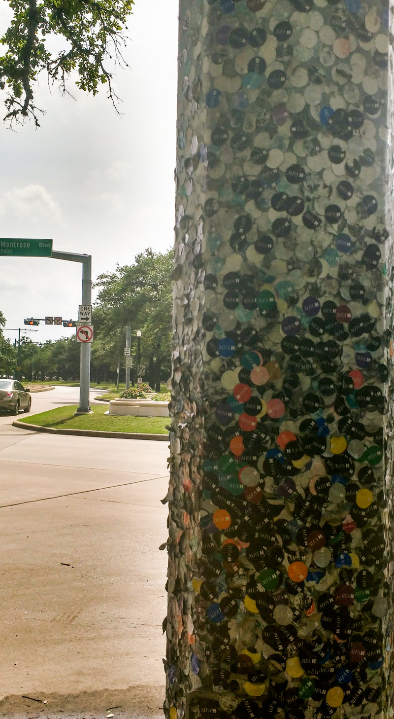
A reader sends a few shots of a developing piece along Fannin St. composed of traffic signal poles and discarded Museum of Fine Arts visitor stickers. The section above can be viewed from the intersection of Fannin with Montrose Blvd. (just south of the Mecom Fountain near the name change to Hermann Park Dr.) To the southwest lies Hermann Park’s Grand Gateway corridor (the string of light-rail-divided esplanades that started getting jazzed up as part of Hermann Park Conservancy’s 100th birthday present to the space); the landscaped strip runs directly north-south from the fountain roundabout to the Sam Houston statue.
Poles in the vicinity have been accumulating stickers since at least 2013. Here are a few more artsy angles on the scene:
Stuck in the Museum District

- 1824 Heights Blvd. [HAR]

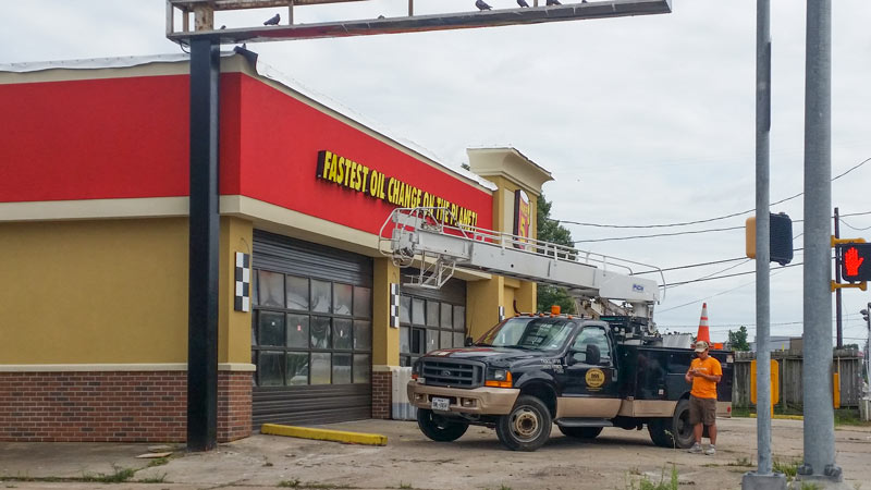
A reader sends the latest from the corner of 19th St. and N. Shepherd Dr., where the facade of the former Mr. Pro Lube and Tune-Up Plus building is now fully swapped out with fresh Take 5 Oil Change logos and exterior branding. The shop is across the street from almost-ready-to-open Dallas pizza import Cane Rosso, and catty-corner to Fat Cat Creamery and its strip-center companions.
Below is a snapshot of what the corner looked like back in 2013 before the trade-out began — and before the space on the corner north across 19th st. changed over from Art & Showcase Flooring to Heights Retreat Salon & Spa:
Strip Center Tune-Up

COMMENT OF THE DAY: WHEN NOT ZONING BECAME BOLD NEW HOUSTON TERRITORY  “. . . Nobody can deny that Houston does things differently, but it does these things in part by not doing something that every other major city does — by bucking the trend despite repeated opportunities to go along with that trend. Houston is so notable in this regard that the Wikipedia page on ‘Zoning in the United States’ has 2 sections of text about the history of zoning: ‘Origins & History’, and ‘Houston’. . . . Houston is the one and only control case that exists by which the impacts of zoning can be tested. To my mind, this qualifies as innovation. Zoning may have been innovative when it was first tried in NYC in 1916, I’ll also grant that — but it’s precisely 100 years later, and — now — Houston’s position is innovative.” [TheNiche, commenting on Houston’s Counterintuitive Optimism; San Jacinto Mall Redo] Illustration: Lulu

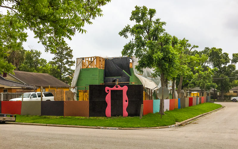
On the corner of McHenry and Carothers streets in Golfcrest, a reader notes both ongoing construction and its increasingly complex backdrop: “They’ve put up walls around [the site], probably for security, but they’ve been dressing up these walls . . . I’m pretty sure that pink door trim is made of vinyl.” County records show that the property (west of Telephone Rd. and south of the South Loop) was sold in February of last year; permits have since been issued related to a remodel and add-on to the 1941 home.
Photo: Tuco Ramirez
Now in Technicolor


Some renderings and potential site plans for a retail redo of 3 warehouses at the southwest corner of W. 18th St. and N. Shepherd Dr. make an appearance in the current leasing listing for the property. Preliminary plans for the development, to be called Lowell St. Market after a former name of N. Shepherd Dr., show a greened-and-glassed-up version of the Savvi Commercial Furniture warehouse (above on the left), with a matching redo of the Airmakers Cooling & Heating building (visible on the far right).
The flier bears the logo of Radom Capital, which is a partner in the Heights Mercantile development on 7th St. Radom is also behind the pink-and-white redo of the former Heights Plaza shopping center on E. 20th, which Steel City Popsicles told Eater they’d be ready to move into some time this month. Plans for the Lowell center are still a ways off, however; the leasing flier gives summer 2017 as an estimated construction start date, but also mentions that sale or leasing of the whole property as-is isn’t off the table.
The 3 structures currently on the site add up to 20,380 sq.ft. of space; the redevelopment would scoot some of that space around and pare it that down to 10,000 sq.ft., making room for a parking lot in the back. Here’s what the footprint could look like following that trim-down:
Lowell St. Market
