COUSINS AND PARKWAY MERGER BETTING ALL AND NOTHING ON HOUSTON’S OFFICE SPACE MARKET 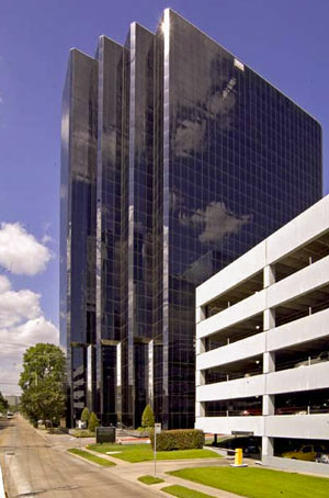 Last week’s merger between real estate investment trusts Cousins Properties and Parkway Properties still resulted in 2 companies, notes Ralph Bivins this morning: the freshly combined firms, keeping the Cousins name, have now moved all of their Houston office holdings (along with nothing else) into a separate trust. The sequestered Houston investments are inheriting the Parkway name (that’s New Parkway, to head off any confusion), as opposed to the originally announced HoustonCo. New Parkway’s properties add up to about 8.7 million sq. ft., including Greenway Plaza (which Cousins bought back in 2013) and 4 other properties in Upper Kirby, Uptown, Tanglewood, and Westchase. Here’s a chance to buy in, Bivins writes, “whether you believe the Houston office market has reached the bottom or not” — noting also that there’s “about 3 million sq. ft. of new buildings still under construction.” [Realty News Report; previously on Swamplot] Photo of 3555 Timmons Ln.: Unilev
Sign up for the Newsletter
Quicklink

YOU MIGHT WANT TO CHECK WHETHER THAT LA MARQUE HOUSE YOU ARE BUYING IS SLATED FOR DEMOLITION 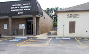 A rep from Greenspoint Investors, which last September reportedly sold Whendy Carreon’s mother a house on the city of La Marque’s teardown list for about $25,000 in cash, tells Kaitlin McCulley that the company didn’t receive notification that the house was condemned until a month after the sale. Reps from the city, however, maintain that the company was notified before the transaction; city manager Carol Buttler says she’s heard of at least 2 other cases in which demo-doomed homes have been sold by other companies to buyers unaware of impending knock-down plans. The city has given Carreon’s family a year to try to get the structure, between SH 146 and Spencer Hwy., up to habitable standards; Joe Compian of Interfaith Gulf Coast, who’s been helping the family with that process, says would-be buyers in the area should check for any city holds on properties before paying in cash. [ABC13] Image of La Marque City Hall: Galveston County Clerk’s Office

H-E-B WILL DOUBLE DOWN ON A HEIGHTS DRY ZONE STORE OR NOT BUILD AT ALL 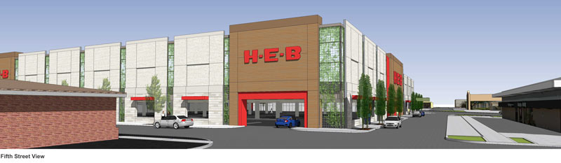 The H-E-B proposed for the former N. Shepherd Fiesta site at W. 24th St. would be another 2-story store, Houston H-E-B president Scott McClelland tells Jack Witthaus. The grocery chain is backing the Houston Heights Beverage Coalition’s dry-zone dampening campaign and showed up for the press conference last week on the now-cleared 4-ish-acre site. The company has already been planning its first double-decker Houston location (rendered above) on the 3-acre site of the existing H-E-B in Bellaire; plans for that development show about 75,000 sq. ft. of store stacked on top of an all-parking ground level. McClelland tells Witthaus that the proposed H-E-B in the dry area of the Heights would be about 80,000 sq. ft. and come with a 2018 expected completion date, but that H-E-B won’t build in the zone at all if the upcoming election doesn’t go their way. [Houston Business Journal; previously on Swamplot] Rendering of proposed 2-story H-E-B in Bellaire: Terra Associates

CITY TO PUSH ALL 146 HOUSTON TAXI COMPANIES ONTO SINGLE SMARTPHONE APP 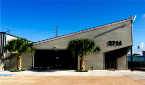 On Wednesday city council approved a plan to require that all licensed Houston cab drivers start taking hails via the same smartphone app, Rebecca Elliott reports. Arro, which rolled out in New York last year and several other major cities since, will tack a $1.50 fee onto the normal cab fare for riders (with a 50 cent-plus-3-percent fee for drivers), and will centralize taxi dispatch across the city. (Limo drivers can get in on the action too, if they want to.) The plan comes in response to not-technically-a-cab-company Uber’s recent threats to pull out of Houston over requirements for fingerprinted background checks for its drivers; Elliott writes that the city wants to have the system up and running by the end of the month. [Houston Chronicle; previously on Swamplot] Photo of Houston Uber HQ, 5714 Star Ln.: Uber Houston

WAIT, DID THE 2008 RECESSION UP THE CHANCES OF A FUTURE HOUSTON CHEMICAL CATASTROPHE? 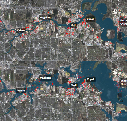 Roy Scranton imagines “a wave of water sweeping toxic waste into playgrounds, shops and houses” in Magnolia Park in his op-ed this morning, written after touring the Ship Channel and speaking with the local A&M and Rice research teams pushing for variations on a series of region-scale coastal barriers to hunker down behind whenever the next gigantic hurricane hits the Houston region, in hopes of avoiding deadly flooding and catastrophic chemical spills. But the researchers tell Scranton that pushing for federal and state funding for a response is a slow endeavor; Jim Blackburn (a main player on the Rice team) tells Scranton that he’s “heard more than one person say our plan is to wait until the next hurricane comes, then depend on guilt money from Washington to fix the problem.” Scranton writes that the best chance for that guilt money so far might have been in 2008, when Hurricane Ike landed just 30 miles northeast of the zone that modelers say could have caused thousands of deaths and irreparable ecological devastation to the area, on September 13th — 2 days before the Lehman Brothers filed for bankruptcy, pulling global attention and national funds to other issues as markets began to crash. [NY Times; previously on Swamplot] Model maps of potential storm surge flooding along the ship channel, with chemical storage marked in red: Texas Tribune

COMMENT OF THE DAY: THAT HIGH HORSE WON’T KEEP YOUR FLOORS DRY  “Wonder how many areas will sue to get out of the high risk zones, only to get flooded years later, have no insurance, and cry foul. Note to those who are able to sue or survey themselves out of a flood zone… buy the insurance anyway! If you are [put] in a high risk zone, right or wrong, you are close enough to warrant the protection.” [Rex, commenting on A Quick Tour of Spots Where FEMA Will Expand Its Flood Hazard Zone In January] Illustration: Lulu

FEDS TO TEXAS: STOP PRESSURING SCHOOLS INTO CAPPING SERVICES FOR KIDS WITH DISABILITIES 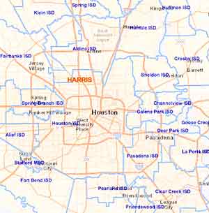 The Department of Education sent out a knock-it-off letter yesterday in response to recently published documentation of a 32% drop in the percentage of Texas students getting special education services — down from 12.1% in 2000 to a seemingly-research-free “goal” of 8.5%. Brian M. Rosenthal reports that the push to reduce the special ed enrollment rate (a policy which was never publically announced) came shortly after the legislature cut the Texas Education Agency’s budget by more than a billion dollars in 2003; the 2004 special ed policy change may have saved the state billions of dollars by withholding federally-mandated accommodations for “children with autism, ADHD, dyslexia, epilepsy, mental illnesses, speech impediments, and blindness and deafness.” Though the agency also couldn’t provide any documentation as to why that target number was picked, educators and district administrators have told Rosenthal that the percentage functions as a de facto cap on how many students can receive services, since failure to come in below the 8.5% benchmark docks a school’s performance rating. Meanwhile, HISD’s own numbers have reportedly gone below and beyond the requirement, diving to 7.4% special ed enrollment versus 19% in New York City. Texas has 30 days to get back to the Department of Education on how it thinks the policy has impacted state school districts, and what it plans to do about it. [Houston Chronicle] Map of Houston-area school districts: TEA School District Locator

THE 82 SQUARE MILES OF TIRZS SPONGING UP SOME OF THAT REVENUE CAP SPILLOVER 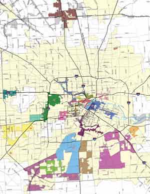 A couple of state senators are mulling over potential reform options for Houston’s ballooning tax increment reinvestment zones, which have more than tripled in area in the past decade according to Mike Morris and Rebecca Elliot’s article in Friday’s Chronicle (which includes a peek-a-boo-style before-and-after slider map for reference).  The zones, shown here on the city’s own map, collected around $109 million dollars of woulda-been property tax money this year for use on development projects inside their boundaries, which (in theory) are supposed to encompass blighted areas in need of an additional redevelopment boost. Morris and Elliot also point out, however, that much of the tax money being collected by TIRZs would be lost altogether if the zones were disbanded at the moment, as the sudden influx would pass Houston’s revenue cap (which limits the amount of cash the city is allowed to collect each year to what was collected in the previous year, scaled up by 4.5% or by inflation and population increases, whichever is less). They also mention that Mayor Turner is pushing for a new vote on the revenue cap in 2017; Turner tells the duo that the city council has stuck with the TIRZ system to make up for some of the potential funds lost by the revenue cap, but notes that “you can only do that for so long without hurting the city as a whole.” [Houston Chronicle; previously on Swamplot] Map of Tax Increment Reinvestment Zones: City of Houston

COMMENT OF THE DAY: DOES ‘EAST RIVER’ ERASE BAYOU HISTORY, OR DRAW IN NEW STUDENTS?  “‘East River’ . . . that does sound like a lame sort of urban infant suckling at Mama NYC’s teat. But really, a 2-word name with each word having a strong, apropos and simple meaning is positive. It is the east part of Houston, and it is a river (called a bayou). But not just [any] bayou — the womb of the city. In the 1840s-60s, the west of the Allen’s Landing section was nothing but a well-wooded open sewer and hideout/hangout for the various characters and scoundrels of Vinegar Hill. [But] east of Downtown it was a river, with masted ships and energetic influx. We should be familiar with every bend of it, but [the bayou’s history is] mostly unknown. ‘East River’ can serve as an introductory directional appetizer for those unknowers who are already here, and those yet to appear.” [Dana-X, commenting on Comment of the Day: The Ongoing Rewrite of Houston’s East Side Story] Illustration: Lulu

YOU MIGHT WANT TO TAKE THAT DIOXIN OUT OF THE SAN JACINTO BEFORE A HURRICANE DOES IT FIRST 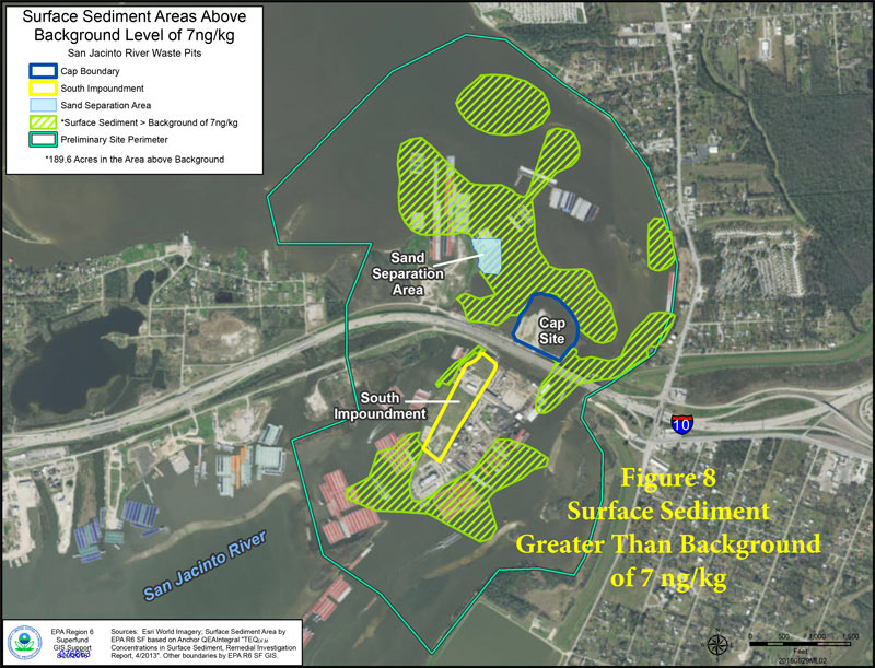 Yesterday marked the start of the 60-day public comment period on this week’s proposal to pull about 202,000 cubic yards of dioxin-laced muck out of the San Jacinto River near I-10. The Houston Chronicle editorial board was among the first to jump in (though not through official comment channels), highlighting the EPA’s conclusion that the waste, which has already been seasoning the seafood and (potentially) the river’s swimmers and nearby residents since the 1960s, could cause much larger problems if the wrong storm or hurricane hits the site; the board also calls out International Paper and Waste-Management-affiliated McGinnis Industrial Maintenance — companies potentially on the hook for the cleanup bill — for purportedly slowing down the cleanup process. [Houston Chronicle; previously on Swamplot] Map of higher-than-background dioxin levels near San Jacinto Waste Pits site at I-10: EPA

COMMENT OF THE DAY: THE ONGOING REWRITE OF HOUSTON’S EAST SIDE STORY  “East River? Ugh, another name copied from New York City. We’ve got the East Village being developed (or is it ‘east village’, in all lowercase?), we’ve got Downtown, Midtown, and Uptown (none of which make any directional sense like they do in N.Y.C.), and now we have this. Is the area around it going to start to be called the Upper East Side?” [GL, commenting on Midway’s Latest Plans for the KBR Site; Big Turnout for the Public Housing Vouchers Waiting List; previously on Swamplot] Photo of former KBR site at 4100 Clinton Dr.: LoopNet

COMMENT OF THE DAY: SAVE-THE-DOME SAGA’S PARKING GARAGE ENDING LEAVES ROOM FOR A SEQUEL 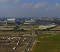 “I think people are missing the larger view here. Of course there is plenty of current surface parking — but putting parking beneath the Dome begins to open up the possibility of densification on this site and on the old Astroworld site. This is the first, and necessary, step in transforming this entire area. I am betting that in 20 years or so this site will barely resemble the vast wasteland of parking lots and open space that it is today.” [SH, commenting on County Approves First $10.5 Million for Astrodome Basement Parking Garage Plan] Photo: Russell Hancock via Swamplot Flickr Pool

HISD TOSSING AROUND A BELLAIRE HS REBUILD ON THE CHEVRON CAMPUS UP THE STREET 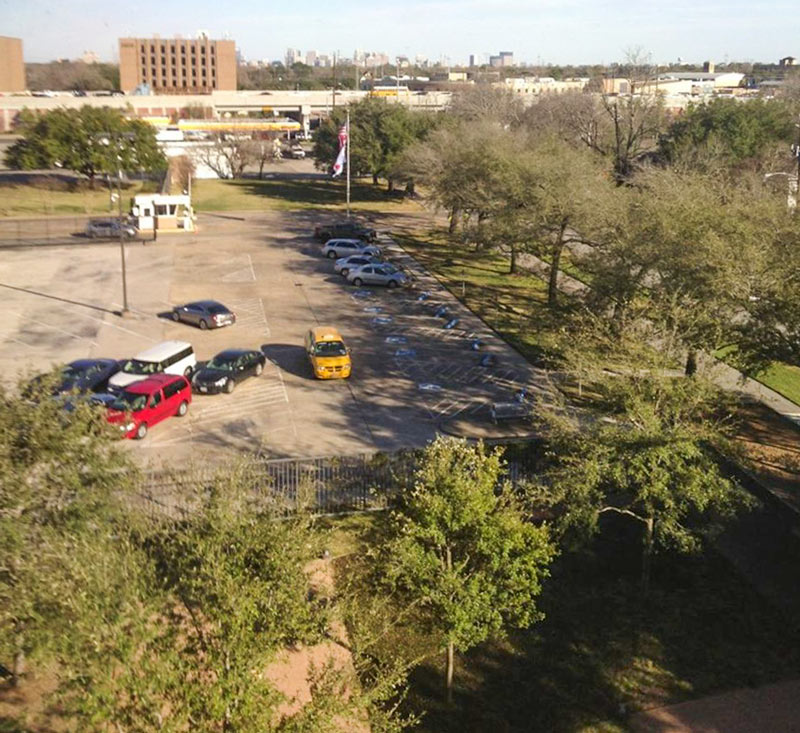 On Monday some HISD folks pitched the idea of buying Chevron’s soon-to-be-empty land on Fournace Place to a committee overseeing the lately-stagnant push to rebuild Bellaire High School, Charlotte Aguilar reports this week. The 28-acre tract, which goes on sale on Saturday, is about 2 miles north of the school’s existing 17-acre campus and also fronts S. Rice Ave. HISD trustee Mike Lunceford tells Aguilar that Bellaire, “while one of the largest high schools in HISD, is on the smallest property.â€Â Principal Michael McDonough emailed stakeholders to say that if HISD decides to back the plan and is able to buy the land, funding would probably be put to a bond election; meanwhile, the existing school would still need some work while a new one was built. The Chevron land currently has a 10-story office midrise on it; the shot above looks out the window of that building toward the West Loop and the freeway-side Shell station next door (also up for sale). [Instant News Bellaire; previously on Swamplot] Photo from 4800 Fournace Pl.: Alvin A.

COMMENT OF THE DAY: ANY NEW NAMING EPISODES WELCOME AMID THE ENDLESS EAST HOUSTON RERUNS  “The news calls everything between Downtown and Baytown ‘East Houston’ — so when West U is called ‘Southwest Houston’ for one day, I get a pettiness-fueled satisfaction out of it.” [tempeh, commenting on West U Shelter-In-Place Order Just Lifted Following This Morning’s ‘Southwest Houston’ Shooting] Illustration: Lulu

COUNTY APPROVES FIRST $10.5 MILLION FOR ASTRODOME BASEMENT PARKING GARAGE PLAN 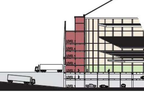 The Harris County commissioner’s court voted this morning to approve the design phase of that plan to fill in the Astrodome’s below-grade levels with a 2-story parking garage. Mihir Zavari writes that today’s vote okayed the first tenth of the estimated $105 million cost, which the commissioners say will be split between hotel taxes, parking revenue, and the county’s general fund;Â Zavari notes that “the general fund component, around $30 million, is roughly equivalent to the amount the county estimates it would cost to demolish the Dome.” [Houston Chronicle; previously on Swamplot] Image of Astrodome parking garage conversion plans:Â Harris County Engineering Department
