COMMENT OF THE DAY: YOU GO RIGHT AHEAD “When I first visited Texas in 1980, the TxDOT signs said ‘Drive Friendly.’ I thought this was a charming sentiment, so when the opportunity came to move here, I looked forward to ‘driving friendly’ with all the other Texans. Imagine my surprise when I got here, and went looking for those ‘Drive Friendly’ signs, only to find they had been replaced by ‘Don’t Mess With Texas’ . . . whoa. OK. My then-new husband told me that just meant that a gunrack gives you the right-of-way.” [Claire de Lune, commenting on Don’t Mess with Don’t Mess with Texas]
Traffic
RED-LIGHT CAMERA SWITCH: OFF The latest signal change in the ongoing saga of Houston’s on-again, off-again traffic-light cameras: City council has just voted to turn off the red-light cameras, again. [Houston Politics; background; previously on Swamplot]
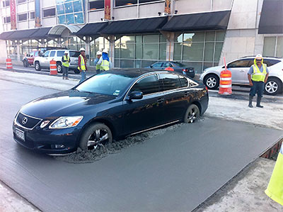
COMMENT OF THE DAY: ENTERTAINMENT VALUE “I hope the driver pays every penny of the damages, minus comedy royalties.” [Sid, commenting on Stuck in Kirby Traffic Again, Not Going Anywhere]
THE 5 PLACES IN HOUSTON WHERE YOU’RE MOST LIKELY TO RUN INTO PEDESTRIANS The intersections of Milam and Dallas, Milam and Prairie, and San Jacinto and Congress St. Downtown; Westheimer and McCue near the Galleria; and Bellaire and Corporate Dr. just inside Beltway 8 in Asiatown rank as the top locations for auto-pedestrian accidents, according to a Chronicle review of city records. A grand total of 2,204 collisions involving cars and people traveling on foot have taken place in Houston since 2008, resulting in a total of 174 pedestrian deaths. The deaths were concentrated differently, “along the U.S. Highway 59 corridor near West Park and along Interstate 45 North and I-10 East,” with 43 percent of them taking place on freeways or major highways. [Houston Chronicle]
COMMENT OF THE DAY: SIMPLY THE BEST “My favorite Red Light Camera is the one on San Felipe & 610 S Feeder. It is so awesome! I’ve tried them all, and that one is definitely the best. Everyone should have a favorite Red Light Camera. What’s yours?” [Jackson Corbett-Bean, commenting on Red Light Green Light]
RED LIGHT GREEN LIGHT The city’s red-light cameras are going back on — effective immediately — Mayor Parker announced today. And after “a short period of equipment testing,” tickets will be issued again. In the meantime, the city will appeal the recent court ruling that invalidated last fall’s vote to turn off the cameras. The mayor said the city would owe millions of dollars “we simply don’t have” if it violated the court decision and the city’s contract with the vendor that operates the cameras. [Office of the Mayor; previously on Swamplot]
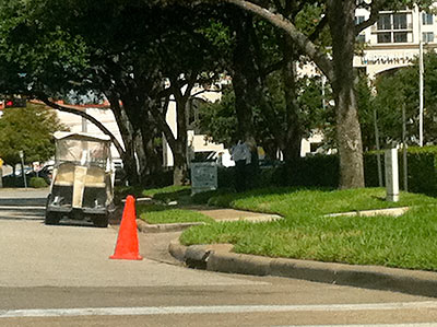
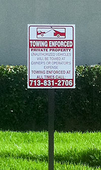 As of Friday evening, new we’re-gonna-tow-you-if-you-park-here signs have been installed along D’Amico St. just north of the new Waugh Dr. Whole Foods Market, reports the Swamplot correspondent who’s been monitoring the parking situation there — and taking in the scene at the new store: “I think the traffic and mass crowds might be worth it,” was the first conclusion, even before the clampdown. These photos, showing the new signs and an American General security detail along D’Amico just west of the office complex parking garage, were taken on a later visit Saturday morning after a follow-up shopping expedition — where our correspondent happily scored 50 bucks’ worth of soda and candy.
- Previously on Swamplot: Later on Opening Day: Whole Foods Montrose Afternoon Parking Report
Photos: Swamplot inbox
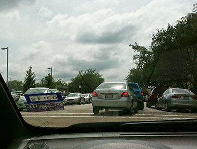
“I don’t know about the Whole Foods parking lot,” writes a Swamplot reader, “but it’s certainly getting real on D’Amico!” Here’s a photo sent in with that report, taken just past the American General Center garage north of the new store on D’Amico St., shortly after 4 pm. But there was plenty of neighborhood-street spillover earlier, too: “Around lunch time, if there was a curb there was a car . . . on both sides along D’Amico, bumper to bumper from the light to just under the garage.” How long will this sort of thing keep up? Our tipster imagines AIG American General will soon put out no-parking signs “along any parts of the street that is their property, such as along the entrance to a parking lot across from whole foods and by the garage. Other areas on the campus have no parking signs where people tend to stop. I know you can’t park within a certain distance to a stop sign, does the same apply to stop lights? If so, some people risked a ticket just to get some groceries! It would be cheaper to pay for parking in the AIG lot or the garage visitor parking.” And no rush, folks. Those free chicken breast coupons are good until next Tuesday.
- Previously on Swamplot: Opening Day: It’s Getting Real Crowded at the Montrose Whole Foods Parking Lot, Beer, Wine, Art, and BBQ on Tap: Here’s Your New Whole Foods Market, Montrose, This Kind of Whole Foods Thing, Getting Real on Waugh at West Dallas This Weekend,
Photo: Swamplot inbox
YOU’RE STILL ON CORNER CAMERA Red-light cameras “continue to monitor intersections,” says Mayor Parker — even though no traffic tickets from the machines are currently being issued. Her comments came in response to a ruling this morning by U.S. District Judge Lynn Hughes that declared last November’s referendum ending the red-light-camera program invalid. The city charter limits the time during which a city ordinance may be repealed; according to Judge Hughes’s ruling, the referendum simply came too late. “Enforcing traffic signals by cameras may be good policy, or it may be bad policy. . . . The court simply must enforce the rules for making policy choices by charter amendment or referendum,” the Judge writes. “Those who favor repeal will react that this distinction is a legal technicality. In some sense, all law is a technicality.” [Office of the Mayor; ruling (PDF); more info; previously on Swamplot]
COMMENT OF THE DAY: THE HUNG BROWSER DEFENSE “I don’t believe that I did [run the red light]. And the alleged video that claimed to show my car going through the light never worked for me, as I never could get the video to load.” [Random Poster, commenting on Red Light Cameras No Longer Recording]
RED LIGHT CAMERAS NO LONGER RECORDING As of 10 this morning, all 70 traffic-intersection cameras have been turned off. Proposition 3, which would have allowed the cameras to continue to snap photos of red-light runners, was defeated by Houston voters 2 weeks ago. “City officials said they have $25 million in uncollected fines from citations that were issued. [Mayor] Parker said the city plans to aggressively go after those violators. City officials have not said when the cameras will be removed from the intersections.” [Click2Houston]
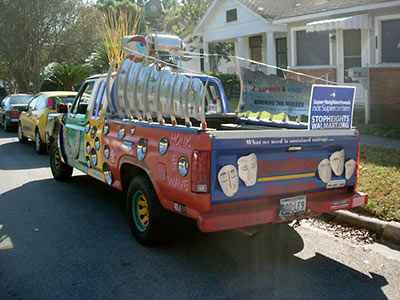
How many cars showed up? “If Steven Colbert can get away with 6 Billion on The Mall, we can call this 22,000…what’s in a number?” asks a reader who says there were actually probably 70 to 100 cars lined up at about 10:15 at last Saturday’s traffic-themed protest of the planned West End Walmart. Comments sent to Swamplot yesterday:
We made the scene at 18th & Rutland during preparation for what one organizer described as a “Flash Mob sort of thingâ€. . . . The mood was fairly lighthearted; it was a beautiful morning after all. Plan was to drive down and around the Koehler Street site and make general mischief, I guess. Saw one TV station camera crew, but did not see anything in print over the next couple of days. Admittedly, I didn’t look real hard.
While I don’t agree with these folks . . . I have to admit, I honor their activism.
“What we need is sustained outrageâ€, indeed!
- Walmart CARNAGE Protest [Stop Heights Walmart]
- Protesters Hit The Streets To Stop The Heights WalMart [39 Online]
- Heights Walmart critics use ‘mobile protest’ to demonstrate traffic impact [11 News]
- West End Walmart coverage [Swamplot]
Photo: Swamplot inbox
WEST END WALMART DEVELOPMENT GETS ITS KOEHLER ST. JOG Despite the protests of a number of speakers — including council member Ed Gonzalez — who wanted some study of neighborhood traffic to be conducted first, the planning commission yesterday approved a minor variance connected with the West End Walmart yesterday, after 2 earlier postponements. The variance allows Koehler St. to be extended from Yale St. to Heights Blvd., even though the resulting street alignment doesn’t meet city development standards. [HTV; previously on Swamplot]
SUGAR LAND EXPERIMENTS WITH FLASHING YELLOW ARROWS Coming soon: the greater Houston area’s first-ever flashing yellow arrow left-turn traffic lights, in 5 signals around the Sugar Land Business Park near West Airport Blvd. and Dairy Ashford! Will you know how to handle them? “The flashing yellow ‘instinctively implies caution,’ which is the preferred reaction when drivers make judgment calls about turning left into a gap in traffic, said city officials. . . . When approaching the intersection, a solid red arrow indicates a required stop – left turning drivers must stop. Drivers must also stop at a solid yellow arrow. A flashing yellow arrow requires motorists to first yield to oncoming traffic and pedestrians before proceeding to turn left. A solid green arrow permits drivers to turn left while oncoming traffic stops. . . . ‘We’ve targeted these initial intersections as part of a phased approach intended to allow residents to become familiar with FYAs [flashing yellow arrows] before utilizing the lights in more densely travelled areas,’ said Assistant Public Works Director David Worley. ‘Our selection of the Business Park will give us the opportunity to refine the timing and ensure education of our motorists.’ Following a six-month study period, the FYAs will be considered for implementation along Eldridge Road, a major north-south corridor through Sugar Land. In addition, a policy will be developed that specifies a process for selection of future intersections.” [Fort Bend Now]

