04/01/10 11:57am

Several retail outlets near the railroad tracks at the base of Heights Blvd. near Center St. are complaining that traffic changes accompanying the new Washington Ave. quiet zone have already hurt their businesses. Department of Public Works spokesperson Alvin Wright tells Channel 39’s Jason Volentine that Federal Railroad Administration requirements mandate that crossovers through the Heights Blvd. median near the tracks be closed off for the quiet zone to be implemented.

Without a quiet zone, train conductors are required to blast their horns at all at-grade crossings. The Washington quiet zone will extend from Sherwin St. north of I-10, to National, about a quarter-mile east of Studewood:

CONTINUE READING THIS STORY

03/29/10 10:55am

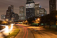
THE ALLEN PARKWAY SPEED TRAP Traffic accidents increased 47 percent and injuries 154 percent on Allen Parkway last year even as the number of motorists ticketed for speeding continued a lengthy and significant decline on the near-downtown roadway, according to police and municipal court records. . . . Houston police, who were unaware of the drop in speeding tickets until asked by the Houston Chronicle and were at a loss to explain them, said they will begin a weeklong study today of motorists’ speeds on Allen Parkway. If high rates of speeding are detected, an enforcement blitz with radar units will begin, said Capt. Carl Driskell, who heads HPD’s traffic enforcement division.” [Houston Chronicle] Photo: Flickr user Lee Ann L.

03/22/10 1:19pm

HAZARDS OF THE WEST LOOP Except for a memorable afternoon of standstill traffic — and the maybe 1,500 gallons of gasoline that made their way through storm sewers to Galveston Bay — no major disaster resulted from that tanker spill 2 Fridays ago on Bellaire Blvd. below the West Loop. That’s better than the last time: “[L]ongtime residents of the area remember an incident in May 1976 when a truck carrying anhydrous ammonia slammed into a bridge railing on the connector from the West Loop to the southbound Southwest Freeway and fell onto the freeway below. Of those within 1,000 feet of the spill, six people died, 78 suffered serious injuries and 100 more were treated for their exposure. That tragedy played out only about a mile from the site of Friday’s accident. Thirty-four years after that terrible day, nothing has changed. The poorly engineered West Loop, as it approaches the 59, is one of the worst sites for accidents in the U.S. — yet it is also designated pathway for some of the most hazardous cargo in the world. More is transported on the vulnerable tracks that run through southwest Houston, divide West University and Bellaire, skirt along Afton Oaks, River Oaks and Memorial Park.” [West University Examiner]

03/01/10 10:06am

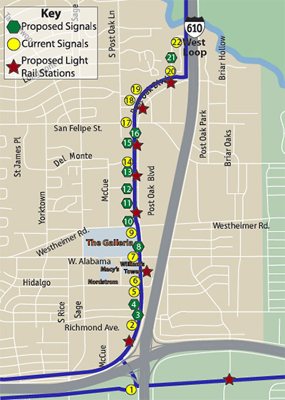
At a meeting last week at Kenny & Ziggy’s Deli organized by Jim “Mattress Mack” MacIngvale, owners of businesses located along Post Oak Blvd.’s vast double phalanx of front-loading strip centers — and representatives of a few of their landlords — groused about Metro’s design for the new Uptown Line and prepared for possible battle. The Examiner Newspapers’ Michael Reed first brought attention to a few quirks of the latest design for the Post Oak stretch of the light-rail line late last year: It features 7 stations, 5 gated crossings, and in all close to 2 dozen traffic signals along the 1.7-mile path from Richmond Ave. to the 610 West Loop. It also blocks all instances of that staple of sprawl-style shopping-center development: the non-intersection left turn.

Had Metro been communicating its plans to the property owners? Had the property owners been relaying any information they received from the transit agency to their tenants?

CONTINUE READING THIS STORY

12/11/09 12:03pm

Once the new Metro Uptown light-rail line is built, Post Oak Blvd. could feature more than 23 stoplights along its 1.7-mile stretch between Richmond Ave. and the 610 Loop, reports the River Oaks Examiner‘s Mike Reed. A report prepared last October by the group of companies contracted to build the new Uptown Line lists 21 stoplights and 7 stations.

But that information’s got to be out of date, right?

. . . in response to questions, a Metropolitan Transit Authority spokeswoman said Tuesday that since the report was written, the number of potential signals has increased to 23, with an additional traffic light and an additional pedestrian light under consideration.

While the proposals contained in such reports are subject to change, the original document indicates the scope of the project combined with the density and development in the area would make substantial alterations to the plan difficult at best.

Reed also reports a few details on the rebuilding of Post Oak:

CONTINUE READING THIS STORY

08/25/09 11:38pm

COMMENT OF THE DAY: WHERE THE SKYSCRAPERS WILL BE BUILT “. . . in a century or two, Houston will be very densely populated. . . . I think Houston is relatively lucky to have street grids across most parts of the city, as opposed to the suburban lollipops in, say, Pearland’s newer subdivisions. When the skyscrapers come — and they will — then Houston’s grids will handle the load better than the lollipops would; and if worse comes to worse, old blocks can be razed for new streets, or our existing streets can be turned into one-way, so that for example you might have Bellaire and Westheimer only go westbound, and Richmond and San Felipe only eastbound (or vice versa).” [J.V., commenting on City to Ashby Highrise: Yes You Can!]

08/24/09 7:52pm

COMMENT OF THE DAY: AFTER THE ASHBY HIGHRISE “. . . My take on it is that this building MIGHT NOT be too bad, once the teeth-on-edge construction period is finished. (And I seem to be the only person who thinks the construction hassles should even matter to anyone. Big crane delivery and setup on Bissonnet, anyone?) But since there seems to be no legal way to stop this one, you can be sure that there will be some serious efforts to put rules in place to prevent any more. My own tongue-in-cheek explanation for why the neighborhood was so taken by surprise is that no-one ever thought for a minute that it made any kind of sense to build a high-rise on Bissonnet, for goodness sake.” [marmer, commenting on City to Ashby Highrise: Yes You Can!]

07/23/09 11:06pm

COMMENT OF THE DAY: MEMORIAL HIGHWAY “I really like the memorials constructed at ‘death-sites’ along roadways: They honor the deceased and alert us to risks, causing us to reflect on how easy it is to die in traffic accidents. I first saw this memorial custom on Grand Cayman Island where signs were erected at the sites of traffic fatalities. Years ago there were only a few, and, the twisted, rusty car wreckages were left in-situ as well. It was vivid and effective: Like performance-art really; Printed in white on the circular, black signs: ‘Accident Black Spot.’” [movocelot, commenting on Comment of the Day: What To Expect on That First Night in Your New Funeral Home]

07/22/09 9:21am

Wondering what’s been going on with the Ashby Highrise? Developer Matthew Morgan tells the River Oaks Examiner that Buckhead Development intends to respond to “the city’s attempts to reach an agreement” with a new submission for the proposed 23-story residential tower on Bissonnet, next to Southampton.

But the city rejected the highrise’s plans again yesterday . . . for the 10th time. The city said its own analysis showed the project as currently proposed would result in an “F” level of traffic at the corner of Shepherd and Bissonnet:

However, “A significant reduction in peak-hour trips, including appropriate trip offsets, could have a potential to address heightened concerns,” a city engineer, Mark L. Loethen, wrote in his comments.

Computing traffic level involves a formula that rates intersection flow from “A” (no traffic) to “F” (very slow).

The rejected plans were submitted April 7, making the three months until they were returned to the developers unusually long.

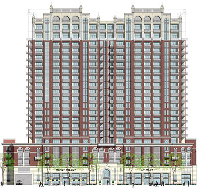
Rendering of proposed Ashby Highrise, 1717 Bissonnet: Buckhead Investment Partners

07/17/09 3:07pm

COMMENT OF THE DAY: FREEWAY TRAFFIC BACKUPS BRING THE CUSTOMERS “I visited the store the first weekend it was open, and overheard the general manager talking about how much more foot traffic the store is getting. He stated the obvious, which I’m surprised no one has commented on yet–think of the hundreds of thousands of people who are stuck in traffic every day on the elevated portion of 59 across from the store. The store’s sign is eye-level to those commuters (whereas it’s actually harder to see the stores on ground level), and you gotta think at least some of them are going to be interested in the store’s wares. Compare that to a low-profile location on Portwest that probably gets 1/10000th the traffic of 59. This is a rare case where being on the second floor of a strip center actually helps a company in Houston.” [Triprotic, commenting on The Finest Strip-Center Recital Hall in Houston]

05/18/09 5:07pm

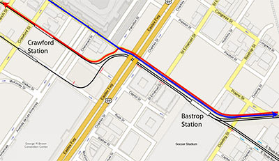
Worried the Dynamo soccer stadium planned for the superblock between Texas, Dowling, Hutchins, and Walker is gonna block traffic between Downtown and the East End? Citizen rail designer Christof Spieler solves the tangle:

There are two parts to this idea. The first is to make Texas alongside the stadium a two-way street. Instead of two eastbound traffic lanes and two light rail tracks, Texas gets two eastbound traffic lanes, two westbound traffic lanes, and two light rail tracks. That all fits in the existing right of way. The second part is to use the “squiggle” in the light rail tracks for traffic lanes as well. This does two things: it gives the westbound traffic on Texas a way to go, and it cleans up those messy intersections.

So now, to get from the East End to Downtown, you simply follow Harrisburg, which flows right into Texas, and then you make a left turn onto Capitol. And you will not hit an awkward intersection or have to cross the rail line to do it.

Map: Christof Spieler

05/13/09 4:08pm

COMMENT OF THE DAY: INNER LOOP TRAFFIC SCARE “I’m always surprised at the people in the Houston metro area who live in the suburbs in order to avoid scary traffic. To me, the traffic in the commercial centers of the suburbs is just as bad, if not worse, than what I encounter within the Loop. My boss dropped me off at home once, with the surprised comment that ‘wow, you can drive from the Med Center to the Heights without going on the highway’. Then proceeded to tell me that the reason he lived in Sugarland was that his wife was terrified of highway driving. I still don’t get it.” [Sunsets, commenting on Sub-Suburban SUV Adventure: Braving That Big Trip “Downtown”]

05/12/09 7:50pm

Spurred on by family members waiting patiently at the Carrabba’s on Kirby — and the promotional whizzes at GM and CBS Radio, who’ve furnished her with a brand-new vehicle to drive for 8 weeks — mommy blogger and new Chevy Traverse spokesmom Stephanie Click ventures out from her “own little world” in Katy to . . . the scary and purportedly trafficky Inner Loop!

Will she make it? How will her blogger-swag loaner car stand up to the rigors of multi-lane Houston driving?

04/13/09 2:59pm

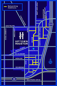
COMMENT OF THE DAY: SMALL STREET ADDITIONS TO THE GALLERIA AREA “The Uptown TIRZ and District are actively working to build a grid in Uptown. Much of it will be funded by existing and new developments by the TIRZ funds and not from the general taxpayer base. . . . [This map shows] their planned addition of grid style layout to uptown. . . . It’ll take existing private access roads and convert some to public streets.” [kjb434, commenting on Uptown Traffic Grid] Map: Uptown Houston District

04/10/09 11:56am

UPTOWN TRAFFIC GRID “As we all know, traffic is incomparably worse in Uptown than it is in Downtown. Downtown has more of everything: more streets, more freeways, more transit, more pedestrian use. The most important part, though, is that Downtown has the grid, and Uptown does not. Uptown is a lot less dense than Downtown, and yet it’s reaching a breaking point. There are critically few ways in and out, and even though those are mega-roads, they concentrate traffic BY DESIGN rather than diffusing traffic as the grid does. If Uptown had a fine-grained local street grid the traffic there would be a fraction of what it is today, but it’s too late to put in a grid now. The best we can hope for is for benevolent developers to include new connecting streets to break up some of the super-blocks when they come up for redevelopment.” [NeoHouston]