06/02/16 10:30am

may-31-flooding-FM-723-rosenberg-2

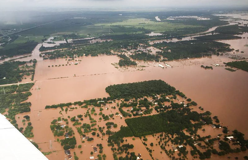
TxDOT has been doing some circling around over the thoroughly soaked Brazos River valley this week grabbing a few snapshots, including some taken yesterday morning as 31 East and Central Texas counties picked up flood-related disaster declarations from the governor’s office. Running north-to-south (right-to-left) under the murky waters shown above is FM 723 in Rosenberg, TX; you can spot the bridge rising up to cross the river’s normal channel on the left side of the photo, while SH 36 stretches away to the northwest.

Flash- and non-flash flood warnings are in effect around the region through at least Friday night, depending on how intense the rest of this week’s predicted downpours turn out to be. Meanwhile, the already-feet-past-the-previous-record flood gauge at nearby Richmond, TX, is still creeping upward this morning toward 55 ft.:

CONTINUE READING THIS STORY

Water Under the Bridges
05/31/16 5:00pm

DEPT. OF PUBLIC SAFETY TO UT: PLEASE DITCH THE PHOTOS OF FLOOD-RELATED CHEMICAL SPILLS WE DIDN’T NOTICE Meanwhile, in Austin: Texas Department of Public Safety officials have recently asked the University of Texas to remove an online collection of aerial photos taken by the Texas Civil Air Patrol during major flooding events, Marty Schladen writes in this weekend’s El Paso Times. The request comes after the Times reported earlier this spring on what appeared to be photos in the database showing a number of chemical spills not captured in any other state monitoring records, including spills along the Trinity river north of Galveston Bay; other photo sets previously on the site reportedly included shots of Houston sewage treatment plants being flooded on Tax Day, as well as possible unreported spills along the Colorado, Sabine, Red, and Pecos rivers since 2014. DPS Spokesman Tom Vinger tells the Times that pulling the photos is a matter of protecting privacy — “for example, there could be pictures of deceased individuals prior to family members being appropriately notified first,” says Vinger. Non-emergency-responders can still ask for the photos via Public Information Act request. [El Paso Times]

05/27/16 10:30am

BRYAN POLICE: PLEASE STOP DRIVING INTO FLOODWATER SO WE CAN WORK ON TORNADO PROBLEMS Flood-related Road Closures, 5/27Dozens of roads are still closed this morning following yesterday’s heavy storms to the north and west. The National Weather Service reports that the nearly 17 inches of rain measured over 24 hours at its Brenham station would by itself beat the total for the 3rd-wettest month on station record (and fall less than an inch short of second place). Bryan-College Station’s The Eagle reported yesterday that the Bryan Police Department was urging drivers to stay off the roads, as first responders were getting tied up with sinking vehicle calls while also trying to respond to calls related to the tornado that touched down near Highway 6 and Briarcrest Dr. At least 50 houses were reported damaged and 3 destroyed; other possible tornado-related incidents reported in the area include damage to the Miramont Country Club and to the Wallace Pack Unit prison in Navasota. [National Weather Service, The Eagle] Map of road closures: TxDOT
05/25/16 4:15pm

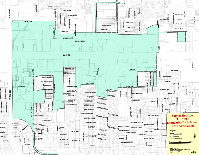
TIRZ 17 boundary

Some Memorial-area residents (mostly under the banner of uncontroversially-named Residents Against Flooding) filed a previously-threatened lawsuit this morning requesting that the city of Houston and TIRZ 17 be barred from using the reinvestment district’s funds for private development projects until more drainage projects have been implemented in the nearby neighborhoods. The lawsuit alleges that the Memorial City Redevelopment Authority and the city have been increasing runoff from the zone (inside Beltway 8 at I-10, shown above in green) into the nearby neighborhoods without adding enough new drainage projects to compensate for it; residential flooding in 2009, last Memorial Day, and this Tax Day are cited as the outcome.

The group filing the suit says it doesn’t want money — so what is the suit asking for?

CONTINUE READING THIS STORY

Memorial City
05/06/16 4:30pm

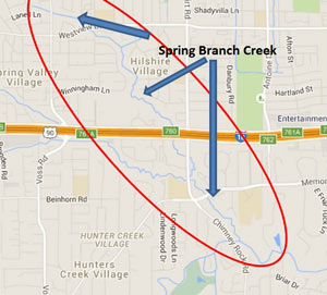
GOOD THING SPRING BRANCH HAD ALL THAT FLOODING LAST MONTH spring-branch-impactsA press release from the city notes that last month’s flooding may actually make the chemical spill caused by yesterday’s warehouse fire significantly less of a problem for the waterways around Spring Branch: Fortunately, recent heavy rainfall and flooding has caused high waters in our creeks and bayous. This will assist in diluting the pesticide contaminates and minimize its impact.” Harris County Flood Control District says the areas of Spring Branch creek marked in the map above (from the site of the fire to the creek’s junction with Buffalo Bayou) should be avoided. [City of Houston; previously on Swamplot] Image: Harris County Flood Control District
05/04/16 2:45pm

ENTIRE LOUISIANA ISLAND POPULATION TO BE TRANSPLANTED WITH FEDERAL ‘CLIMATE RESILIENCE’ FUNDS Meanwhile, in Isle de Jean Charles: Planning is currently in the works to resettle roughly 60 people following the gradual disappearance of more than 90 percent of their island due to a combination of industrial and climate change factors, including sea level rise, subsidence, erosion along manmade channels, and the blocking of wetland-rebuilding sediments by levees and other flood-control structures. The community, mostly members of the Biloxi-Chitimacha-Chocktaw tribe, is frequently blocked by flooding from jobs and schools on the mainland. In January, the first-ever  federal National Disaster Resilience Competition awarded $92 million dollars to the state of Louisiana, which has lost nearly 1,900 square miles of coastal land since the 1930s. Some of the money will go to the Isle de Jean Charles move, and the rest will seed a state fund to help finance other coastal “resilience” projects anticipated in the coming years. A total of $1 billion dollars for similar projects was awarded through the competition to 13 applicants (8 states and 5 communities); the city of New Orleans received a separate grant for $141 million. [New York Times, U.S. Dept. of Housing and Urban Development]

05/03/16 4:30pm

A set of 4 new FEMA disaster recovery centers opened yesterday, sprinkled around the north and west sides of Houston hit hardest by the Tax Day flooding. The locations include a Greenspoint office building right across Greens Bayou from some of the apartment complexes evacuated during the flooding (including Arbor Court). The other centers opened Monday in Meyerland, Cypress, and Spring, and additional temporary help centers might get set up elsewhere around town.

As of yesterday night, FEMA had already received nearly 12,000 applications for post-flood assistance. Harris County reported last week that more than twice as many homes were damaged by the April floods as reported during last year’s Memorial Day flooding. Farmers Insurance agent Peter Zografos told the Houston Press last week that many of the same houses have filed claims a second time: “Some of these homeowners may have to be insured directly with the National Flood Insurance Program due to repetitive claims, [and] basically will be charged more for too many flood claims.”

Map of FEMA disaster recovery centers: City of Houston

Still Under Water
05/03/16 1:00pm

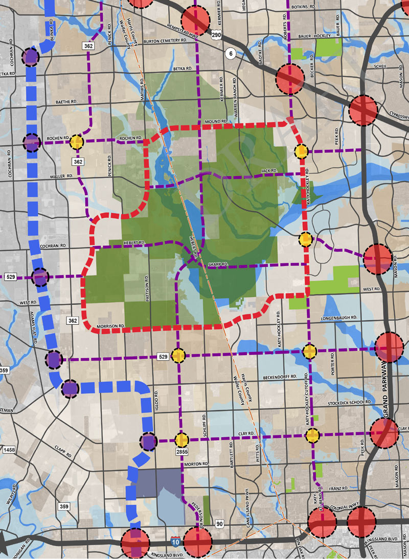
Proposed Changes to Major Thoroughfare Plan near 290 beyond Grand Pkwy.

If you missed yesterday’s meeting in Hockley, you have until Wednesday to send Harris County your thoughts on the map above, from the official county study of road network expansion proposed between I-10 and 290 west of the Grand Pkwy. The thick red dashes mark a proposed loop road circling around almost the entirety of the Katy Prairie Conservancy‘s land preserve (shown as the darkest green blocks, amid slightly-grayer-green agricultural/undeveloped land and a few kelly-green public parks). Purple dashes show the proposed routes of new or expanded thoroughfares, some of which cut through the preserve and cross through the Cypress Creek floodway (shown as a blue underlay making a rough U through the conservancy’s land).

Further west (marked in blue dashes) is the not-yet-planned-but-still-showing-up-in-planning-maps route of Houston’s proposed outer-outer-outer loop, SH 36A (formerly nicknamed the Prairie Parkway). The map above also includes overlays of Harris County’s future development predictions, with dark taupe showing existing development and slightly lighter taupe showing expected expansion.

For comparison, here’s the Katy Prairie Conservancy’s map of west Houston; currently developed areas are marked in gray, the organization’s protected areas are marked in green, and the dashed green band shows how far the prairie ecosystem used to extend:

CONTINUE READING THIS STORY

Up the Watershed
04/27/16 12:45pm

COMMENT OF THE DAY: STRIKING AT OTHER ROOTS OF HOUSTON FLOODING Digging into Houston soil“St. Augustine grass has a very shallow root system that barely reaches 2 inches into the soil. Beneath that root system is our typical thick clay gumbo soil that is very slow to drain moisture and more prone to let water run off into the storm sewer system. When you plant native grasses and plants, the roots reach down much deeper in the soil and fundamentally change the [bulk] composition of the soil. Instead of the thick gray clay gumbo soil, you get a much looser brown soil that does a much better job absorbing and holding water instead of letting it run off into the storm sewer system . . . Just imagine the amount of water that could be kept out of the storm sewer system if everyone replaced the St. Augustine in their front yard with native grasses and plants.” [Old School, commenting on Houston’s Sustainability Question; Fire Destroys Cleburne Cafeteria in the Middle of the Night] Illustration: Lulu
04/27/16 11:30am

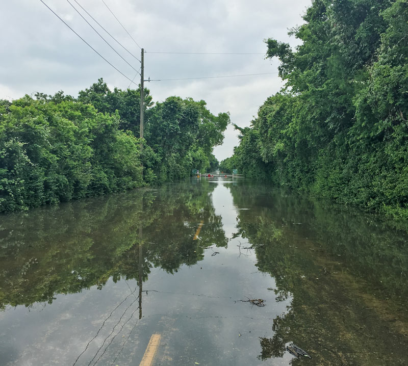
Barker Clodine Rd. in Barker Reservoir, Houston, 77084

A reader caught the view above during a lunchtime bike ride into the Barker reservoir yesterday. The shot shows the nearly submerged stop signs on the currently-closed road barricade where Barker Clodine Rd. merges into the hike-and-bike trail system running throughout much of the reservoir (which stretches between I-10 and the Westpark Tollway just west of Hwy. 6). The Corps of Engineers has been releasing water from both Barker dam and its sister reservoir Addicks across I-10 since Thursday — but the level behind the dams continued to rise for a few days as additional water drained into the basins from the surrounding watersheds, faster than that water could be safely released downstream into Buffalo Bayou.

Both Barker and Addicks reservoirs’ levels finally began dropping on Saturday — though both started filling again briefly on Sunday as water from later-in-the-week storms trickled east from the surrounding watersheds. Below is an up-to-date look at Barker reservoir’s change in storage since the Tax Day flood, per USGS measurements:

CONTINUE READING THIS STORY

Addicks and Barker
04/26/16 4:30pm

The footage above captures Ed Nelson’s high-water trek last Monday through an overflowing detention basin at the corner of Bob White Dr. and Reamer St. just north of Brays Bayou. Nelson narrates his soggy expedition through the basin (which sits at the south end of the Robindell and Braes Timbers neighborhoods, between Hillcroft Ave. and Fondren Rd.) as he attempts to document different flows of water into and out of the pond; he ultimately claims that water is flowing into the detention pond from Brays, and moving from there into the floodway easement running behind nearby houses on Reamer.

Nelson and other neighbors claim that the surrounding area did not flood prior to the detention basin’s completion in 2008, and that the detention pond was intended to collect water from the surrounding neighborhood and prevent it from flowing too quickly into Brays bayou  — whereas during the Tax Day and Memorial Day floods, the basin purportedly collected water from the bayou and channeled it into the neighborhood, causing houses to flood that neighbors believe might not have otherwise.

CONTINUE READING THIS STORY

Brays Out of Bounds
04/25/16 2:45pm

COMMENT OF THE DAY: A HISTORICAL METHOD OF EXPANDING HOUSTON’S FLOODPLAINS Illustration of Flooding House“Another recent policy development is that subsidence is now taken very seriously (with massive infrastructure being built to put utility districts onto surface water from Lake Houston and the Trinity River). But it was a very, very big problem up until around 1990. So you had all this sprawling development inside of Beltway 8, and off of 1960, and out near West Oaks, and there wasn’t adequate on-site or off-site stormwater retention infrastructure that had been built — and that same development thereafter was sinking at a steady rate, so that any flood control infrastructure was becoming increasingly obsolescent for reasons other than simply rainfall rates and runoff.” [The Niche, commenting on Comment of the Day: Who Foots the Bill for Houston Floods] Illustration: Lulu
04/22/16 3:30pm

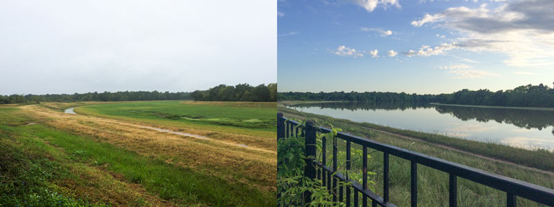
A water-watching reader sends some south-facing photos from yesterday evening (right) and last October, comparing views over the fenceline of the 400-ft.-wide diversion channel at the northern edge of the Addicks reservoir. The channel picks up most of the flow from Langham and Horsepen creeks where they join up as they flow south into Addicks. The 400-ft.-wide floodway was dug in the 1980s; the flow usually lurks down in the narrow channel seen in the shot on the left.

The scene above is less than a mile east of Bear Creek Village, where water is now moseying into neighborhoods from the western edge of the reservoir (and washing some wildife and livestock around). The Army Corps of Engineers has been releasing water from both Addicks and Barker dams to minimize the pooling (and relieve stress on the dam structures themselves) — but those releases have to be done slowly enough to avoid causing additional flooding downstream along Buffalo Bayou. Meanwhile, water is still flowing into the reservoirs from western watersheds; the measured levels behind the 2 dams topped all previous water level records and normally allowed pooling limits in the reservoir by Tuesday, and has been rising since. Here’s a shot of water gushing out through some of the gates of the Barker dam this afternoon:

CONTINUE READING THIS STORY

Drinking It In, Spitting It Out
04/21/16 4:45pm

Potential Flood Map, Bear Creek, Houston, 77084

The Army Corps of Engineers will begin releasing water from the Addicks and Barker dams later this evening; nonetheless, water levels in the reservoirs are still expected to rise high enough to cause street flooding in the Bear Creek subdivision north of Clay Rd. The Corps also notes that nearby residential areas should anticipate that wildlife inhabiting approximately 26,000 acres of forested land in the 2 reservoirs may flee the rising water and enter nearby neighborhoods. That wildlife may include the feral pigs previously targeted by Harris County Precinct 3’s trapping-and-foodbanking program; sightings of animals such as deer, coyotes, and bobcats have also been reported in the reservoirs.

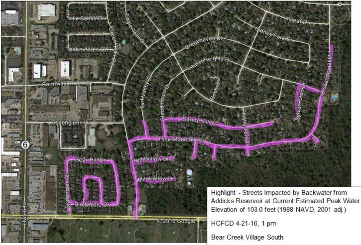
Harris County Flood Control District has published a list of streets that could be impassible for days or weeks due to flooding, as well as a few maps (one of which is shown above). Here’s the other map below, highlighting in pink the streets south of Addicks Satsuma Rd. and Langham Creek expected to get water when the level in Addicks reaches 103 feet:

CONTINUE READING THIS STORY

Creeping Into the Neighborhood
04/21/16 3:00pm

COMMENT OF THE DAY: WHO FOOTS THE BILL FOR HOUSTON FLOODS Flooding Coastal Homes“Since much of the development inside the Loop is done over existing impermeable surfaces, it would seem to me that the majority of the additional demand on our bayous is coming from the large greenfield production builders further upstream. My intuition is that the amount of building going on out there most likely dwarfs what’s occurring inside the Loop (can anyone find numbers on this?). And what’s really fueling all that development is the billions of federal, state, and local tax dollars going [toward] expanding and enlarging highway construction all over the place. By reducing the time/cost of commute, they serve as enormous incentives enabling building and selling more cheap houses further away from the employment centers closer to the city. In a nutshell, that is the sprawl Houston is famous for and I think the main source of our flooding woes. There’s no easy answer since we all want cheaper houses — but someone pays for that, somewhere.” [Build Up, commenting on Why Houston Keeps Flooding; Meet Photo Blog Purple Time Space Swamp] Illustration: Lulu