COMMENT OF THE DAY: THE BLACK HOLES WHERE FREEWAYS INTERSECT  “Freeway interchange corners like this one seem to be tricky places for anything to last a long time. The long flyover ramps create this weird phenomenon where you have to exit a couple miles back and ride the feeder to that spot. Yet those same ramps make the property very prominently visible to tens of thousands of people each day who pass by overhead in their car. For whatever reason, the properties seem to cycle in and out of use and disuse. The changeover is probably exacerbated by construction freeway construction, widening, and ramp rebuilds.” [Superdave, commenting on The End of the Greenspoint Mall Is Upon Us] Illustration: Lulu
Sign up for the Newsletter
Tag: Freeways and Toll Roads

COMMENT OF THE DAY: WHY HOUSTON FREEWAYS SHOULD BE BUILT TO FLOOD  “. . . Why would you NOT want a massive freeway that would otherwise be empty in the event of a true emergency to flood? Spend the money on barriers/signage for flooding, throw in some pumps and you have a perfect deterrent for neighborhood flooding in the event of an emergency. I don’t remember any of the surrounding areas along 59 complaining about it being a great place to store flood water during Allison.” [joel, commenting on What Could Go Under When I-45 Moves Underground and East of Downtown] Illustration: Lulu

WHAT COULD GO UNDER WHEN I-45 MOVES UNDERGROUND AND EAST OF DOWNTOWN 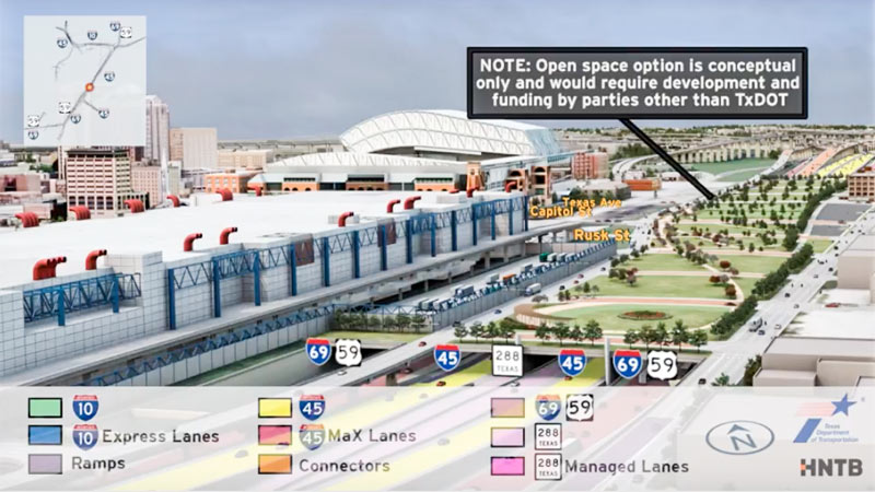 Jeff Balke tallies some of the expected carnage just east of Downtown should TXDoT proceed with its planned rerouting of I-45 from the west side to the east side of Downtown, widening the path of that stretch of Hwy. 59 (aka I-69) to Saint Emanuel St. Among the establishments expecting to have to shut down or relocate as a result of the expansion: the Bayou City Barber Shop, Vietnamese restaurant Huynh, Ahh Coffee, Tout Suite, one building of the Ballpark Lofts, low-income housing development Clayton Homes, a couple of nonprofits, SEARCH Homeless Services’ new building, the Loaves and Fishes soup kitchen — plus other assorted bars, barbecue joints, artist spaces, and office space. Among the questions Balke keeps hearing in reference to plans to put this portion of a new I-45-69 combo below grade, possibly (only if separate funding can be found) with a greenspace “cap” planted on top of it: “why [would] a freeway would be constructed lower than street level in a city that floods with seeming regularity, particularly when the highway in question is a hurricane evacuation route? TxDOT is quick to point out that we already have roadways below grade throughout the city that have not suffered major flooding problems since Tropical Storm Allison in 2001, which broke records and is widely considered a 500-year flood. Still, flooding is something the agency appears to have taken seriously. ‘No matter the situation, there’s a potential for flooding,‘ [TXDoT spokesperson] Perez explains, ‘but with anything below grade, additional pumps and detention ponds come into play.’ [Houston Press; previously on Swamplot] Rendering showing possible park behind GRB: HNTB and TxDOT


Among a few Fifth Ward buildings abutting a new railroad underpass scheduled to be installed near the intersection of Lyons Ave. and West St.: The warehouse pictured above at 2305 Lyons Ave., graced by a Wiley Robertson mural. The Gulf Coast Rail District plans to eliminate the at-grade railroad crossing west of I-69 and directly to the east of that corner by routing Lyons Ave. under the tracks. According to the district, 30 trains a day currently cross Lyons Ave. — on 3 separate sets of tracks. North of Lyons, 3 additional at-grade crossings will be eliminated by closing down West St. entirely from a little south of Lyons to a little south of Brooks St.
The earliest possible start date for the project, which would cost an estimated $28.5 million and take approximately 2 years to complete, is listed as the fall of 2020. At a meeting last night at the Saint Arnold Brewery, which is just west of the West St. intersection, the district and TXDOT showed these images of a widened Lyons Ave. with dual 12-ft.-wide car lanes as well as bike lanes and sidewalks passing under the HB&T rail line:
Underpasses and Overpasses

BIG I-45 DOWNTOWN REROUTING, GRAND PARKWAY EXPANSION GET GO-AHEADS 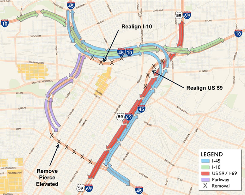 Yesterday was a big day for Houston freeway expansion and reconfiguration: On Tuesday, the Texas Transportation Commission gave the go-ahead for construction to begin in late 2020 on the first of 7 separate projects that will move I-45 from the west and south sides of Downtown to its east side, paralleling U.S. 59 behind the George R. Brown, reports Chron transportation writer Dug Begley. Separately, the commission also selected design and construction crews for the next segment of the Grand Parkway, from I-69 near New Caney to I-10 east of Baytown. How grand that section of the Grand Parkway actually ends up being may depend on your perspective: This segment of the Houston area’s fourth ring road is expected to cost $1.25 billion and open in 2022 — but the tollway will have only a single lane in each direction. [Houston Chronicle; previously on Swamplot] Diagram of I-45 rerouting: TxDOT

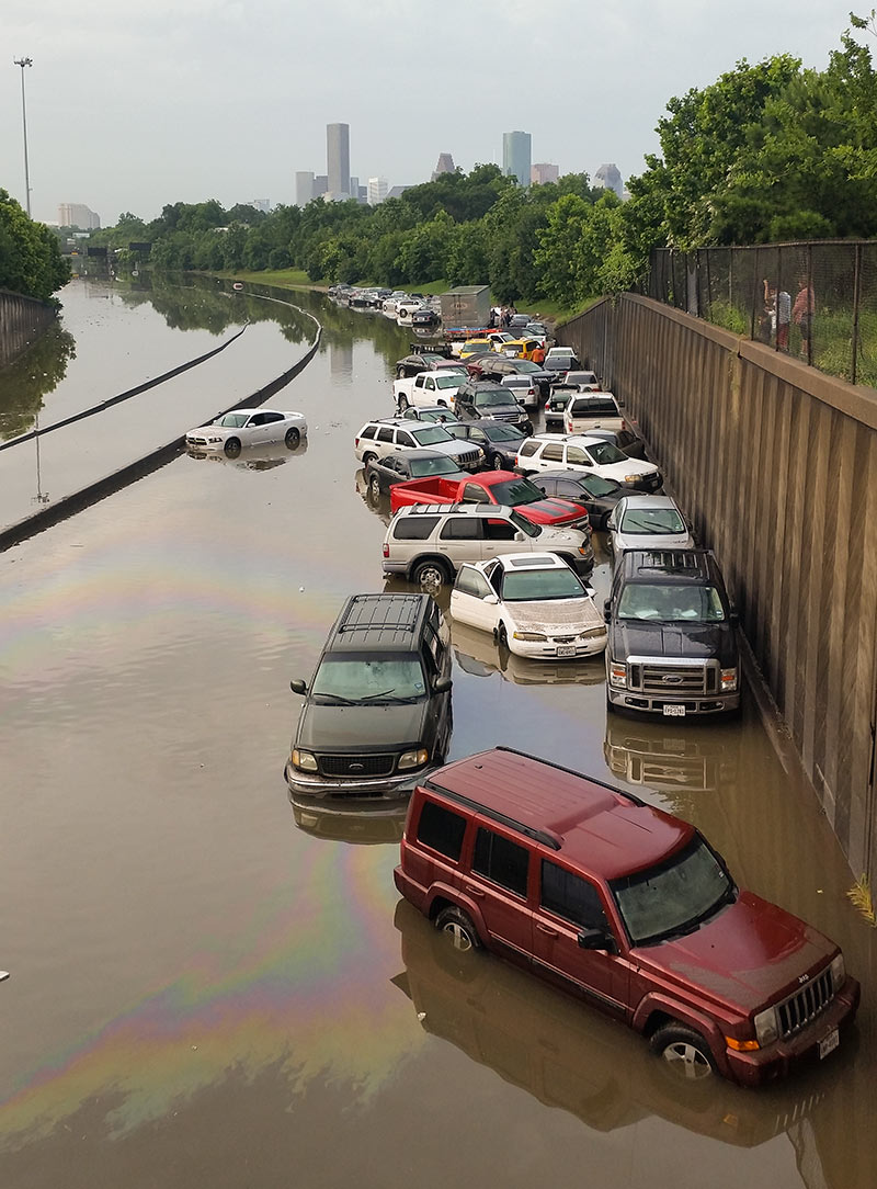
If you’re compiling a list of best photo spots for during or after another one of Houston’s every-dozen-years-or-so never-seen-anything-like-it flooding events, you’ll probably want to make room on it for the stretch of I-45 North between the N. Main St. and Patton St. exits. Back in 2001, images of cars and trucks floating along an insta-lake in this same spot made national news. And yesterday, pix of the automotive flotilla pictured above found their way to Facebook feeds and front pages around the globe.
But the low spot just north of Downtown wedged between Brooke Smith and the Near Northside was also a tough place to be when the water started rising, reports the Chronicle‘s Dane Schiller. Drivers found an early morning traffic jam in the rain changed nature quickly: “A surge was coming at them, squeezed by high barrier walls into the confines of the interstate. In less than 15 minutes, there was nothing to do but abandon ship.”

If you were dazzled by the wide swaths of concrete laneage and complicated color-coded spaghetti interchange entanglements in the TxDOT renderings released last week — but had trouble comprehending the massive scale of the proposed reroute of I-45 around Downtown — you’ll want to try this second go at it. The state transportation agency has now produced a video version of its freeway-rewrapping proposal, complete with tiny little animated cars and trucks moving along 3-D representations of those new wide surfaces. It’s so mesmerizing, many viewers may not even notice what happened to the Pierce Elevated.
- Previously on Swamplot: The 5 Wackiest Images from TxDOT’s Plans To Reroute I-45 and Abandon the Pierce Elevated
Video: TxDOT, via Houston Chronicle
North Freeway Downtown Rewrap

COMMENT OF THE DAY: WHAT A DIFFERENCE A TWIST IN THE HIGHWAY WOULD MAKE  “Pretty sure inside the Loop/outside the Loop won’t matter once TXDOT completes the planned half twist there at the 610/59 interchange. Cars will then be able to drive on the top and bottom of the Möbius 610 Loop, which should greatly reduce congestion.” [Memebag, commenting on Houston Chronicle Building Goes on Sale Tomorrow, the Chronicle Reports] Illustration: Lulu

DRIVING BELTWAY 8, IN ORDER TO READ HOUSTON IN THE ORIGINAL 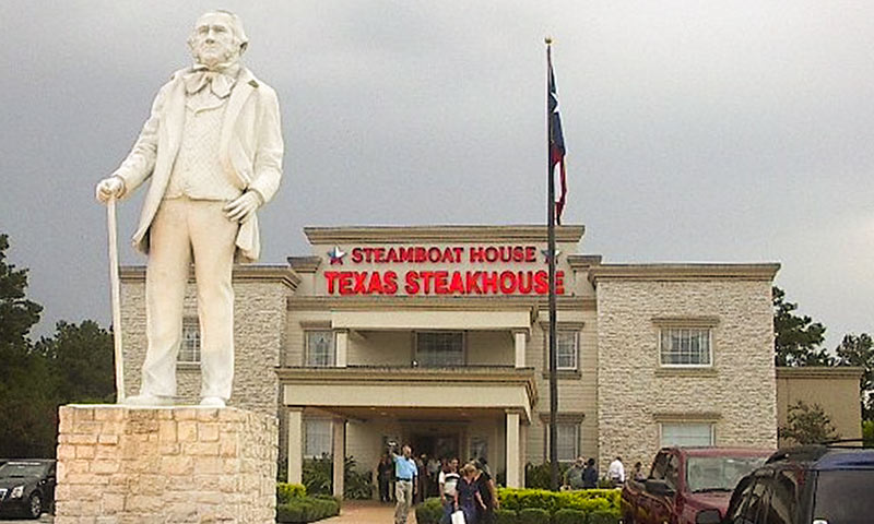 “To get a full sense of the place,” writes Cort McMurray, every Houstonian should travel Beltway 8’s full 83-mile circuit. Until you can find the time, though, his tour narrative may have to suffice: “Keep going. You’re not even halfway around. There are more factories, and more office buildings, more new construction, more traffic. There’s a steak house, built to look like Sam Houston’s Huntsville home, evidence that if you give a Houstonian a little time and a little encouragement and the right financing, a Houstonian will create something ridiculous, and the horse track, where nothing ever appears to be happening. Near Bush Intercontinental, you’ll endure Roadwork Purgatory: orange cones and narrowed lanes and blinking signs, and no evidence of any work being done. It’s been that way for 19 years.
East of the airport, the Beltway crosses vast swaths of tract homes and the strip centers and megachurches that inevitably follow them, funneling you toward the Jesse Jones Bridge, standing like the skeleton of some humongous sauropod, head forever bent to the Ship Channel, nosing about for some seaweed.” [OffCite] Photo of Steamboat House Steakhouse: Tomball Sesquicentennial Promenaders
“To get a full sense of the place,” writes Cort McMurray, every Houstonian should travel Beltway 8’s full 83-mile circuit. Until you can find the time, though, his tour narrative may have to suffice: “Keep going. You’re not even halfway around. There are more factories, and more office buildings, more new construction, more traffic. There’s a steak house, built to look like Sam Houston’s Huntsville home, evidence that if you give a Houstonian a little time and a little encouragement and the right financing, a Houstonian will create something ridiculous, and the horse track, where nothing ever appears to be happening. Near Bush Intercontinental, you’ll endure Roadwork Purgatory: orange cones and narrowed lanes and blinking signs, and no evidence of any work being done. It’s been that way for 19 years.
East of the airport, the Beltway crosses vast swaths of tract homes and the strip centers and megachurches that inevitably follow them, funneling you toward the Jesse Jones Bridge, standing like the skeleton of some humongous sauropod, head forever bent to the Ship Channel, nosing about for some seaweed.” [OffCite] Photo of Steamboat House Steakhouse: Tomball Sesquicentennial Promenaders

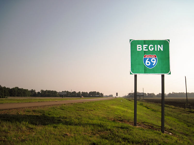
Snickers and awkward guffaws are likely to be heard all the way from the Northside to Afton Oaks next week, once state transportation officials sign off on the addition of another name to the 11.9-mile segment of State Hwy. 59 within Houston’s Inner Loop: Interstate Highway 69. New signs announcing I-69 proudly to the world will subsequently be erected along in-town stretches of the freeway, where they’ll likely be targeted for pointed display in neighborhood bars, strip clubs, or dorm rooms.
Once complete, I-69 will connect the highway’s head at the Canadian border in Port Huron, Michigan, to its tail along the Mexican border, where it will spread into 3 separate paths to Laredo, McAllen, and Brownsville. Planners hope the availability of a smooth, continuous ride from north to south and back again along the eventual federally sanctioned route (sometimes called the NAFTA Superhighway) will stimulate and ease trade among the entwined nations.
Making the Link

TXDOT LIKELY TO CUT FUNDING FOR WEST LOOP BUS LANES, SHIP MONEY SOUTH 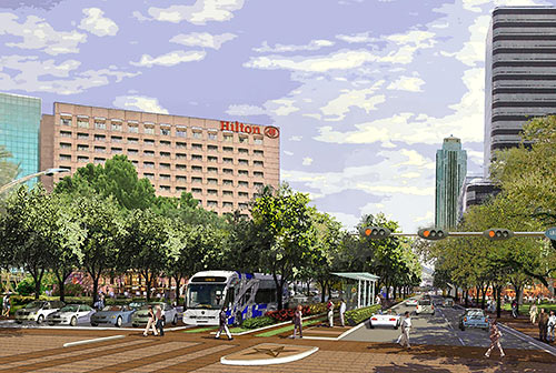 In a move that could spell doom for the Post Oak Bus Rapid Transit project, TxDOT’s planning director said Thursday that his agency is now recommending it ax a $25 million commitment to expanding connecting bus service along the West Loop. The plan called for elevated bus lanes  running along 610 from Post Oak Blvd. to the Northwest Transit Center near the Katy Fwy. and 610. The agency now claims that the $25 million would be better spent on an improved Texas 288–Beltway 8 interchange. [The Highwayman, previously on Swamplot] Rendering: Uptown HoustonÂ

COMMENT OF THE DAY: TOP HOUSTON PUNCH LINES  “If an out-of-towner wanted to make fun of Houston, there are a multitude of easier targets than the Rothko Chapel. Just the drive in from the airport on I-45 will give any out-of-towner loads of risible material.” [Robert Boyd, commenting on Sniffing Out the Subtle Secrets of the Rothko Chapel] Illustration: Lulu

A SLIGHT TRAFFIC DELAY ON THE PATH TO BUILDING HOUSTON’S FIFTH RING ROAD 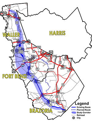 There’s the 610 Loop, Beltway 8, Highway 6 and FM 1960, and the Grand Parkway. What will come next in the grand sequence of giant highways encircling Houston? Why that might be Highway 36A, also dubbed the Prairie Parkway, possibly because the segment of the Grand Parkway opened just a few months ago through similar natural landscape is now already too urbanized to hold onto a prairie-styled name. But the apparent eagerness of Waller County commissioners to have additional tolled segments added to link Highway 36 to State Hwy. 6 (the Waller one, not the West Houston road of the same name) to form what would likely become Houston’s fifth ring-road orbit path hit a slight bump yesterday, possibly because of opposition led by the Katy Prairie Conservancy, whose lands stand in the path. A scheduled vote on a proposed resolution in support of a highway-boosting support group called the Highway 36A Coalition and its request for TxDOT funds to study the proposed 107-mile corridor was withdrawn before it could be discussed, according to a report on Facebook posted by someone who attended the court session. “Instead, a ‘workshop’ has been scheduled for next Wednesday, May 7, immediately after the Court’s regular session,” reads the report. In public comments, according to the attendee, all 11 people who spoke about the proposed highway “seemed skeptical of the project in general.” [Citizens Against the Landfill in Hempstead; previously on Swamplot] Map showing path of proposed Prairie Parkway: Highway 36A Coalition

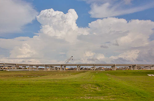
The portion of the newly tolled Grand Parkway between U.S. 59 and US 90A (and a little further north, to FM 1464) quietly opened to traffic last Thursday. Segment D of the third or fourth ring road around Houston (depending whether you count the Hwy. 6 and FM 1960 combo), which extends about 18 miles from the Southwest Fwy. to I-10, has been open since 1994 — but mostly as a sleepy divided double-lane highway with a super-wide grassy median. The new tollway redo is being opened in spurts. The Fort Bend County Toll Road Authority, which controls this portion of Segment D, expects to have the complete stretch of tollway open between the Southwest Fwy. and the Westpark Tollway open by the end of April. When it opens, 7 automated toll booths will line that stretch.
- Current Projects [FBCTRA]
- Remaining sections of Grand Parkway Segment D set to open by end of year [Impact News]
- Grand Parkway coverage [Swamplot]
Photo: Fort Bend County Toll Road Authority
59 to 90A and Growing

COMMENT OF THE DAY: HOUSTON’S MAIN STREETS OF DISTRACTION  “The fact that its not facing the freeway is progress. For too long, Houston has used its freeways as a super fast main street.
One of the reasons why the traffic is so bad in this area is that people gawk at the purdee buildins facing the freeway in addition to the excessive on/off ramps within a 2 mile stretch.” [DNAguy, commenting on This 21-Story Office Tower Is Headed for the West Loop’s East Side] Illustration: Lulu
“The fact that its not facing the freeway is progress. For too long, Houston has used its freeways as a super fast main street.
One of the reasons why the traffic is so bad in this area is that people gawk at the purdee buildins facing the freeway in addition to the excessive on/off ramps within a 2 mile stretch.” [DNAguy, commenting on This 21-Story Office Tower Is Headed for the West Loop’s East Side] Illustration: Lulu
