01/09/14 10:15am

Plan for Memorial Park Demonstration Project, Buffalo Bayou near River Oaks, Houston

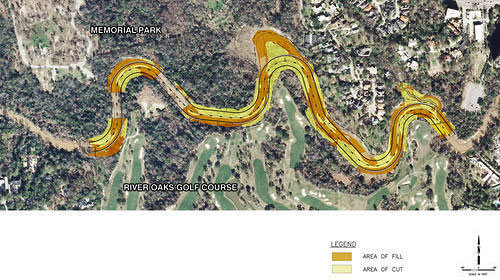
in this week’s Houston Press, writer Dianna Wray wades into the murky waters surrounding the Harris County Flood Control District’s plan to move and rebuild the banks of Buffalo Bayou where it winds between Memorial Park and the River Oaks Country Club. The method of “natural channel design” the district plans to use in the $6 million project is meant to keep the bayou in place, using downed trees instead of concrete. But weren’t bayous born to wiggle? “If the Army Corps of Engineers approves the Memorial Park Demonstration Project permit application,” Wray writes, “construction workers could move in by the end of this year, using heavy equipment and saws to reshape the bayou according to a pattern that should, if the method is successful, lock the waterway into a form it will hold for generations to come. If the effort fails, the entire project could be blown down the river by one heavy flood, leaving nothing but naked, unprotected soil where the last of an ancient forest once stood.”

Plan of Memorial Park Demonstration Project: Harris County Flood Control District

The Banks of River Oaks
10/23/13 4:30pm

Here’s a rendering that shows how that informal dog bowl along Buffalo Bayou near Montrose Blvd. will be formalized and capitalized into a Dog Park. Construction, says a PR rep for the Buffalo Bayou Partnership, will begin the first of the year; the park should be open next winter.

Why, you might wonder, would it take that long to build a place for dogs to romp and run and bark and stuff? Part of it will be creating the pond you can see in the rendering. The pond, which will be treated with a “bio-filter” and native vegetation, is meant to keep said dogs 1) safe and 2) away from the bayou, so they don’t muddy up the banks scrambling in and out of the water and contribute to erosion. Other additions? A purty fence that will separate the pups from the joggers and 2 pavilions, at the top of the hill, that will provide a bit more shade.

Rendering: SWA Group

09/26/13 10:00am

Here’s a concept that HKS came up with for a site just behind the Hotel Granduca, Montebello, and Villa d’Este towers in Uptown Park. The concept shows how it might go if you wanted to build a conference center and a combo hotel-condo tower on 14 green acres between Tilbury and N. Wynden off S. Post Oak, just west of the Loop. This rendering shows the boxy exterior of what appears to be the conference center flanking a linear park shooting off from the banks of Buffalo Bayou.

CONTINUE READING THIS STORY

09/24/13 12:05pm

Now have at it: SmartGeometrics has made available for free on a website launched yesterday the data from 3D scans of the allegedly leaky, 87,500-sq.-ft. 1927 underground water reservoir near Sabine St. along Buffalo Bayou. Though the Buffalo Bayou Partnership would like to do something cool with the “accidental cathedral,” as Houston Chronicle columnist and cistern sympathizer Lisa Gray has called it, there’s no more funding available. Thus, the partnership is hoping some smart cookie who knows her way around AutoCAD (and programs like it) will use this free data to come up with an idea that woos someone or something else — like, say, Bud Light — to pay to make it happen.

Image: Buffalo Bayou Park

09/23/13 3:00pm

COMMENT OF THE DAY: WHEN IT RAINS, IT’S RECOUPED “I live close to Buffalo Bayou. I lost two cars during a heavy rain in 2009. The water came up too fast to save the cars. By the time I found out they were flooding they were in a couple feet of snake infested water. The insurance company paid up right away and didn’t raise my rates. These people should have no problem if they have insurance.” [jgriff, commenting on Headlines: Putting the Creek in Cross Creek Ranch; Flooding the Omni Hotel Parking Lot] Illustration: Lulu

09/09/13 12:30pm

WHAT’S BEST FOR BUFFALO BAYOU? Let it flow, or let it be? Environmentalists and the Harris County Flood Control District disagree — at least when it comes to the 1.5-mile stretch that contributes to the “jungly ecosystem” of the Hogg Bird Sanctuary in Memorial Park, reports the Houston Chronicle’s Lisa Gray. A “restoration” plan proposed by the flood controllers, explains Gray, “would change the bayou’s course in places, fill in an oxbow here, reinforce banks there, widen the bayou’s channel, raising and lowering landmasses and generally move an enormous amount of dirt. [They argue] that the proposed measures are desperately needed to reduce erosion and improve water quality.” They’d do it here as they did it at Meyer Park along Spring Creek, reports Gray. But the environmentalists don’t seem to consider that to have been a “restoration” project, really: “‘Look at that!” [Memorial Park Conservancy board member Katy Emde] told me, outraged, showing me a picture of Meyer Park on her phone. ‘There’s no diversity! It’s not natural! It’s not habitat! It’s horrifying.'” [Houston Chronicle ($); previously on Swamplot] Photo of Hogg Bird Sanctuary: Bayou Shuttle

09/03/13 10:00am

Dude! Got a snazzy idea for that 1927 underground water reservoir near Sabine St. on Buffalo Bayou, but you just can’t picture what’s down there? Well, grab the potato chips and crank up Pink Floyd, because now you can. The Buffalo Bayou Partnership is reaching out in the hope that entrepreneurs, artists, and visionaries the city over will use the above video, created by SmartGeometrics, for inspiration. (And more 3D images are forthcoming on the partnership’s website.)

CONTINUE READING THIS STORY

08/30/13 11:15am

The dirty work continues: Here are some photos of the progress, as of last night, of the Buffalo Bayou Partnership’s big plan to soup up the soupy waterway.

Above, you can see the new view from Eleanor Tinsley Park, where site work is underway for the Bud Light Amphitheater. Picnic tables, a volleyball court, playground equipment, and a few pine trees are all long gone.

After the jump, you can see more photos of dirt. And photos of the newest pedestrian bridge, inserted between the Houston Police Memorial and the rear of Glenwood Cemetery.

CONTINUE READING THIS STORY

08/19/13 2:15pm

USING PICTURES TO PICTURE USES FOR BUFFALO BAYOU’S BASEMENT There’s still no real plan for that 1927 underground reservoir along Buffalo Bayou near Sabine St. But, reports the Houston Chronicle’s Lisa Gray — one devoted parishioner of this “accidental cathedral” — there’s now a new technology in place that might help would-be entrepreneurs visualize the possibilities: “SmartGeometrics, a company whose main business is creating super-precise 3-D digital models of real places . . . will show video-game-like digital models to the public . . . and will explain how, soon, the data will be available to anyone who wants to plug it into his design software. . . . ‘This is a starting point for us,’ [Buffalo Bayou Partnership’s Guy Hagstette] says. ‘We’re trying to decide on the big picture. What should the concept be? Is it environmental art? A giant nightclub? A parking garage?” [Houston Chronicle ($); previously on Swamplot] Photo: SWA Group

08/07/13 5:00pm

Thanks to $2 million from Silver Eagle Distributors, which is also putting up that new beer dispensary in Pasadena, the Buffalo Bayou Partnership might to be able to afford to turn Eleanor Tinsley Park into something as purty as what you see in the rendering above. That means the existing “event meadow” down below there along Allen Pkwy. will be scooped out and rid of the volleyball court, playground equipment, picnic shelters, and some of the pine trees, then re-landscaped and rechristened the Bud Light Amphitheater; more parking and stairs will be introduced; and a new “Skyline Overlook” pavilion will be built and named in honor of Silver Eagle prez and CEO John Nau.

The dirty work began earlier this month, says the BBP, part of the overall project to install new swag like pedestrian bridges and remove invasive species, transforming the 2.3-mile stretch, BBP prez Anne Olson explained a few months ago to Free Press Houston, into an “11 acre urban prairie.”

Rendering: SWA Group

07/01/13 4:00pm

The latest pedestrian bridge to span Buffalo Bayou was craned into place this past Thursday. The 345-ft. bridge almost hooks up with the skinnier chain-linked one that spans Memorial Dr. from Jackson Jackson Hill St. on the north. The Buffalo Bayou Partnership’s master plan shows that this bridge will serve the so-called Lost Lake — a space for which is being cleared of all kinds of vegetation just west of this site. You could say that the bridge might also encourage Rosie Ruiz-inspired joggers to take a shortcut and avoid going the extra mile around the Shepherd Dr. bridge-under-a-bridge just a bit farther west.

CONTINUE READING THIS STORY

05/31/13 11:00am

FIGHTING THE INVADERS OF BUFFALO BAYOU Though much of the Buffalo Bayou Partnership’s (BBP) plans for that eponymous waterway involve adding things — kayak rental shops, pedestrian bridges, etc. — there seems to be the need for subtraction, too: “‘People look at the park and see that it’s filled with trees and grass, what most people don’t realize is that most of those plants shouldn’t be there,'” BBP’s prez Anne Olson tells Alex Wukman of Free Press Houston. “A study of the park’s vegetation, which the Partnership filed with the Texas Forest Service, found Buffalo Bayou to be overrun with invasive species — primarily White Cedar and Chinese Tallow. . . . Olson explained that the Partnership plans to combat the invasive species problem by removing 50 percent of the park’s lawn, which is mostly made up of easily-maintained but non-native Bermuda grass, and replacing it with native grasses.” Adds Olson: “‘We’re going to create an 11 acre urban prairie.'” [Free Press Houston; previously on Swamplot] Photo: Flickr user barryDphotography

05/08/13 12:30pm

This photo, courtesy of a reader, shows what will eventually hold up the new pedestrian bridge spanning Buffalo Bayou. This view looks south across the muddy water from the Sandy Reed Memorial Trail near Jackson Hill St. and Memorial Dr. toward the Royalton condo tower on Allen Pkwy. Crews have also begun clearing away more trees and brush between this spot and the Adath Yeshurun Cemetery, where the bayou’s master plan shows the Lost Lake will be.

CONTINUE READING THIS STORY

02/05/13 3:00pm

This Commerce St. parcel of property will be up for auction on February 14, reports Real Estate Bisnow‘s Catie Dixon. Owned by Cushman & Wakefield, says Dixon, the Downtown lot bound by Elysian and Austin is almost 29,000 sq. ft. of surface parking — for now, anyway — that stares at Minute Maid Park. Maybe the most important detail is that the lot backs up to Buffalo Bayou . . .

CONTINUE READING THIS STORY