MICHAEL JORDAN’S ALL-STAR BIRTHDAY BASH IN MANSION BEYONCé LIKES FOR HER MOM?  Though rumors suggest that Beyoncé might soon snap it up for her mother, Tina, this steeply discounted Piney Point Village mansion near Buffalo Bayou has been the getaway destination for luxury-seeking out-of-towners like rapper Wiz Khalifa, reports CultureMap’s Shelby Hodge. According to its Vacation Rentals By Owner listing, the 21,640-sq.-ft. lodging goes for $25,000 a week from September to April — chump change for an NBA demigod like Michael Jordan, who, reports Hodge, might be renting the mansion to get his 50th birthday on while he’s in town during NBA All-Star Weekend in February. The VRBO listing doesn’t mention a security deposit; let’s hope Jordan hires someone to clean up before Beyoncé’s mom moves in. [Houston Chronicle; CultureMap; previously on Swamplot] Photos: HAR
Tag: Buffalo Bayou
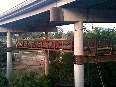
Courtesy of Swamplot reader James Glassman, here’s a shot of what’s been connected so far under the Shepherd Dr. overpass as it crosses the end of Allen Pkwy. at Buffalo Bayou. Suspended ’neath the cars at this gateway to River Oaks: a new pedestrian bridge, which will link the aptly named Sandy Reed Memorial Trail along the bayou’s South bank with Memorial Dr. to the north. Here’s how it’s drawn out in the Buffalo Bayou master plan:
COMMENT OF THE DAY: BUFFALO BAYOU WILDLIFE “Years ago I saw someone pull a snapping turtle out of that bayou, near the Shepherd bridge. Vicious-looking brute; the snapper was mean, too.” [Brian, commenting on Headlines: Americana Remodeling Plans; a Place for the Houston Blues Museum]
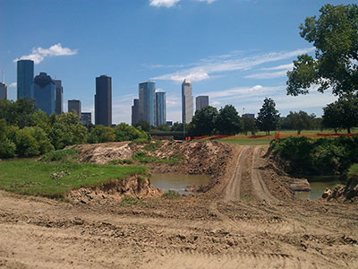
Reader Jeromy Murphy sends a couple pics of a temporary ford of Buffalo Bayou seen last week near the site of the Police Officers Memorial off Memorial Dr. just west of Downtown. Planned nearby: a new permanent pedestrian bridge that will make the memorial accessible to soulmates hanging about in Glenwood Cemetery to the north. The bridge will also open the memorial to visits from bikers on the recently updated trail on the bayou’s north side.
This map shows the plan:
COMMENT OF THE DAY: UP FROM THE SHIP CHANNEL “Many will think I’m crazy, but I don’t care . . . Buffalo Bayou (even on the east side of downtown) can be an aesthetically pleasing stream, and could be developed into something nice. Look at the recent improvements and re-naturalization at Eleanor Tinsley park, just a mile upstream. The section between downtown and the Ship Channel (the S.C. technically does not begin until the Turning Basin, about 4 miles east of downtown) is currently mostly idle with vegetated banks and a surprising variety of wildlife. A few more floating litter booms like they use upstream would clean it up a little more, and make for a nice park-like setting.” [Superdave, commenting on Along the Shores of Buffalo Bayou]
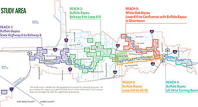
Looks like that Charting Buffalo (as in Buffalo and Lower White Oak Bayous) draft report might not have gone over so well. A popup note shown to first-time visitors to the project’s website, posted just last Friday, dryly notes the entire report has been pulled — only 2 days after it first went out for community feedback: “In light of compelling issues regarding the presentation of certain concepts in the Charting Buffalo draft report, the Harris County Flood Control District is in the process of modifying the report. The District is suspending the report’s distribution, review period and all scheduled community meetings until further notice,” it reads. The feedback period for the report, intended to form the foundation of a master plan for reducing flood damage along the entire Buffalo Bayou and lower White Oak watersheds from the Barker Reservoir to the Ship Channel Turning Basin, was originally scheduled to extend until April 1. Possible flashpoint: the “more than 40 options for reducing flooding risks and damages” spelled out in the report. The Charting Buffalo project was the flood control district’s response to a City of Houston request to “provide land” for stormwater detention.
- Draft Report [Charting Buffalo]
- About the Study [Charting Buffalo]
Map of Study Area: Charting Buffalo
LOCAL WEBSITE MAKES BOOK 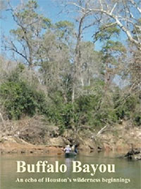 Does li’l ol’ Buffalo Bayou qualify for a river guide? It does now. Longtime bayou history boat tour guide Louis Aulbach — author of 5 river guides chronicling the courses and histories of a few West Texas waterways — has just published Buffalo Bayou: An Echo of Houston’s Wilderness Beginnings as a book. If you’re a bayou or local history buff and that title sounds familiar, it should: Aulbach has been posting extended excerpts from the project on his old-school HAL-PC website for years. [Memorial Examiner; Amazon link]
COMMENT OF THE DAY: LICKED CLEAN BY MILLIONS OF COCKROACHES “Roaches? I didn’t leave them out. I just didn’t see any — as in, not one. No living creatures at all, except us humans. The place smelled clean, like fresh water. I wonder where those roaches went…. and (ugh) what they were eating down there in the ’80s.” [Lisa Gray, commenting on Comment of the Day: The Cockroaches Found That Cistern First]
COMMENT OF THE DAY: THE HOUSTON MUSIC UNDERGROUND “it sounds really really cool, but aside from asking Pauline Oliveros to re-record her Deep Listening album i can’t think of a single thing that would make good use of an abandoned cistern.” [joel, commenting on Poking Around in Buffalo Bayou’s Abandoned Basement]
POKING AROUND IN BUFFALO BAYOU’S ABANDONED BASEMENT 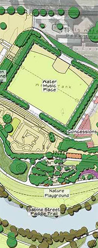 Lisa Gray finds echoes, art, and a few dramatic rays of light in the giant abandoned 1927 underground reservoir near the Buffalo Bayou at Sabine St., under the planned site of a new outdoor performance pavilion: “The question now, of course, is what to do with the Cistern. [Buffalo Bayou Partnership’s Guy] Hagstette says that everyone now agrees it won’t be used for parking or storage. But what should it be? How should the public have access to it? And how will it be paid for? (The Cistern was discovered after the Buffalo Bayou Project had budgeted all its Shepherd-to-Sabine money for other projects.) When we reached the far end of the Cistern, we left the ledge, walking down concrete stairs to the muddy floor. The silty red mud, Shanley explained, was composed of iron and other minerals that long ago settled out of the reservoir’s water. Every now and then, a drop of condensed water from the ceiling would hit the soft mud, and the tiny sound would echo. Shanley shone his flashlight on the ground, examining the droplets’ marks. ‘It’s like the surface of Mars,’ he said.” [Houston Chronicle; previously on Swamplot] Site plan for Water Music Place on top of reservoir: Buffalo Bayou Partnership
COMMENT OF THE DAY: EACH INGREDIENT IS IMPORTANT “. . . it IS the bayou odor, the bat guano smells, the methane sewer gas & auto exhaust fumes that combine to make the ‘Houston smell’!” [Patrick, commenting on More Pedestrian Bridges and Other Twists and Turns in the Plans for Buffalo Bayou Park]
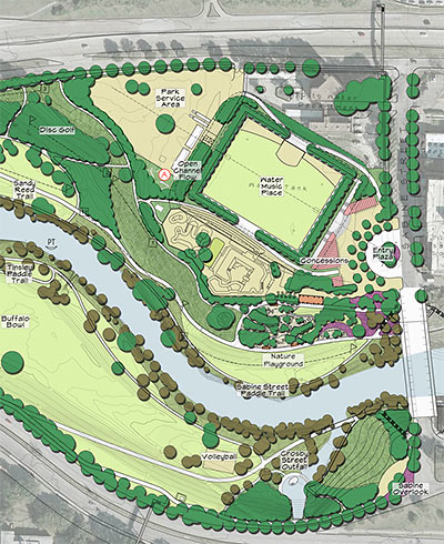
Part of the $50 million plan to turn the banks of Buffalo Bayou west of Downtown from Sabine St. to Shepherd Dr. into a single, continuous linear park: a new entry plaza on Sabine St. at the city waterworks station (near the skatepark, above), a small lake at the end of Dunlavy St., and 3 new pedestrian bridges. One of the bridges is planned for a site just east of Shepherd; another across from the police officer memorial; and the third at Jackson Hill St. Also: lighting, new water features, public art, renovated trails, and a dog park. A separate, $5 million project funded and run by the Harris County Flood Control District will attempt to return the bayou to a more “natural” configuration — by removing sediment and invasive plants and building in bluffs, sandbars, high and low banks, possibly some additional twists and turns, and other more genuinely bayou-ish features. Here’s a plan of the whole thing (turned sideways to fit):

Making its debut last night at the Sabine Promenade downtown: The Buffalo Bayou Invasive Plant Eradication Unit, equipped with gardening tools, microscopes and plant presses, and a taco-truck style ordering counter where you can report or learn about the latest local vegetation battles. The food-truck-style mobile exhibit and lab is the work of New York artist Mark Dion, commissioned by the Houston Arts Alliance and the Buffalo Bayou Partnership. Next stops: the Holly Hall Retirement Community Plant and Bulb Mart at 2000 Holly Hall St. (on Friday) and the Native Plant Symposium at the Omni Hotel at Eldridge Parkway and the Katy Freeway (Saturday). Look for the converted Ford van with the skull and crossed pitchfork and shovel.
- Fighting Invasive Plant Species, One Mobile Artwork at a Time [Art Attack]
- Traveling artwork to be unveiled Wednesday at Sabine Promenade [YourHoustonNews]
- With aliens invading, the Buffalo Bayou Partnership rolls out a plant eradication truck (not a food truck) [Culturemap]
Photo: Meredith Deliso

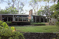
This home nestled on the south bank of Buffalo Bayou north of Woodway and just outside the West Loop has made brief appearances in the MLS for the last 2 fall seasons. This time, though, the price is almost $200K lower. It’s a 4-bedroom, 3-1/2-bath open-plan home designed by William Floyd in 1954, sporting a few obvious updates and alterations. The 3,519-sq.-ft. home is now on the market for $1,299,000; it’s just a few doors down from the home fellow architect Preston Bolton built for himself on Pine Hollow Ln. 16 years later.
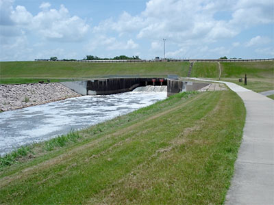
In what appears to be a last-ditch effort to block construction of Segment E, the straight-throught-the-Katy-Prairie section of the Grand Parkway scheduled to begin construction this month, the Sierra Club has filed a new suit against the Army Corps of Engineers, the DOT, the FHA, the Texas Transportation Commission, and several public officials. But the lawsuit also focuses attention on the health of the Addicks and Barker Dams on Buffalo Bayou, which control waterflow through west and Downtown Houston. According to a July 2010 document unearthed by the environmental group this past March through an information request, the Army Corps has rated the status of both dams as “urgent and compelling” since September 2009; that rating indicates the Corps considers them to be 2 of the 6 most dangerous dams in North America.

