MIDWAY: GIANT FIFTH WARD KBR SITE WON’T BE CALLED NORTHBANK BUFFALO BAYOU, BUT SOMETHING ELSE MIGHT 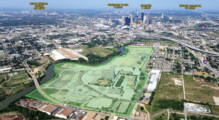 A representative from Midway tells Swamplot that, while the company has been working on a trademark for the name Northbank Buffalo Bayou, it won’t be used for whatever the company is planning for the 136-acre former KBR site in Fifth Ward (which was recently bought by a Midway affiliate). The name is actually connected to another project floating around on the company’s drawing board — no confirmation yet as to exactly where that development might be located, if it comes to be, but the north bank of Buffalo Bayou seems like a reasonable guess. Wherever the moniker is applied, the US Patent and Trademark Office lists the name as intended for use related to both commercial and residential real estate marketing and construction. Also on the list of things the brand could be used for: wine and food tastings, and presenting live musical performances. [Previously on Swamplot] Listing photo of KBR site: LoopNet
Sign up for the Newsletter
Tag: Buffalo Bayou

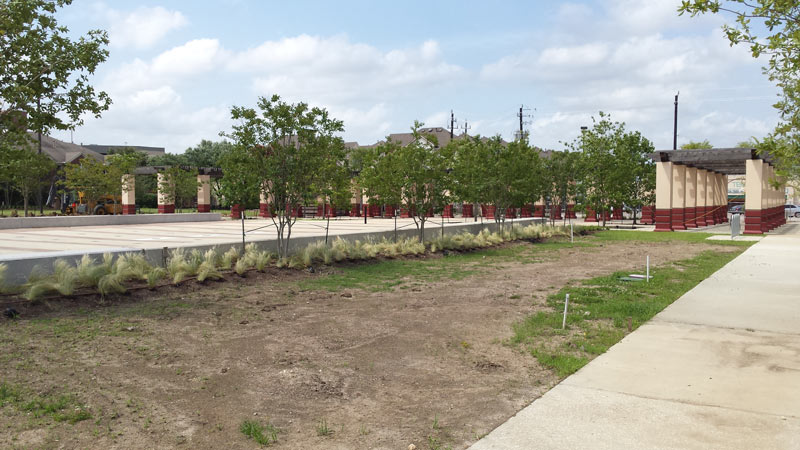
The forest of columns behind the newly planted trees above are most of what’s left of the original central plaza structure in Second Ward’s Guadalupe Plaza Park, which the Greater East End Management District says will reopen on July 30th as several years of de- and re-construction work are wrapped up. The 1980s park now caps the western end of the previously redone Navigation Blvd. esplanade, and a landscaped sidewalk now connects the park to Buffalo Bayou at the crossing of Jensen Rd. (right across from the 136-acre KBR campus recently purchased by mixed-use developer Midway).
Here’s the view looking south along the walkway toward the main square from alongside cultural center Talento Bilingue, which the management district says won’t be knocked down until funding is in place to rebuild it:Â
Plaza Placement

This week’s video release from hometown country singer Robert Ellis takes viewers on a forlorn wandering tour of Houston’s downtown and surrounding thoroughfares, sans all of those pesky people and cars. Iconic cameos include the AIA’s future headquarters on the corner of Franklin and Commerce streets, the WALD warehouse sign at Live Oak and Rusk streets, and Bad News Bar on Main St.; the video also includes a hike down a dead-empty I-45 and associated entrance ramps, several frantic light-rail stops, and a dramatic reunion on the pedestrian bridge over Memorial Dr. at Sabine St.Â
- Robert Ellis shares video for touching new single “How I Love You†[Consequence of Sound]
Video: Robert Ellis
Musical Background

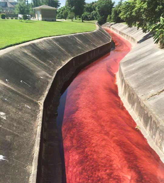
The ditches ran red in the Spring Branch area yesterday as the billowing 4-alarm fire near Laverne St. at Spring Branch Dr. triggered evacuations and shelter-in-place orders across the surrounding areas. The blaze reportedly started in a home-slash-auto-shop on Laverne and spread next door to the A-1 Custom Packaging warehouse (which transfers large quantities of various industrial liquids into smaller bottles for distribution). Some of those stored chemicals (including the bright red petroleum additive visible in the shot above) made their way into drainage ditches and culverts flowing into Spring Branch itself.
The red additive is non-water-soluble and has been getting pushed around by contract clean-up crews downstream to stop the spread. But contractors cannot, the city says, catch the pesticide that also made its way into the same drainage channels, as it dissolves in water. It’s still unclear how much of the 500 gallons or so thought to have been stored at the site made it all the way into Spring Branch (which flows into Buffalo Bayou south of I-10), but some water quality test results are due back later today.
River Running Red

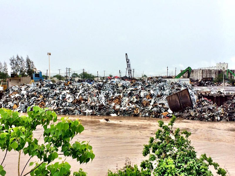
Bryan Parras snagged some after-shots of Buffalo Bayou’s up-and-down number near Tony Marron Park just east of Hirsch Rd. this week, as the rain let up on Monday afternoon and again yesterday morning. Across the channel on the north bank is the Sims Metal Management’s Proler Southwest recycling facility, whose scrap piles shown above were still soaking their toes beneath the freshly-elevated water line at the time of the Monday photos.
Below is a view of both the park’s trails and the Sims facility, looking east from the Hirsch bridge across the bayou’s confluence with somewhat-redecorated Japhet Creek from the north:
Piled High in Fifth Ward

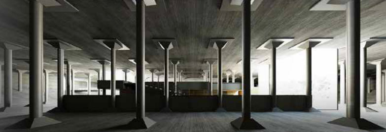
 As Buffalo Bayou Partnership continues to seek out tour guides for the cavernous 1927 city water reservoir and maybe-future-art-space buried in Buffalo Bayou Park, University of Houston architecture grad Sheridan Staats sends over her design for turning the structure into a split-level public bath house, complete with pools, saunas, gardens, a bike trail connection, and a cafe. Renderings and schematics are showcased in Staats’s undergraduate thesis, which also dives into global bath house and infrastructure history and the case for reusing the site in a way that nods to its utilitarian aquatic past.
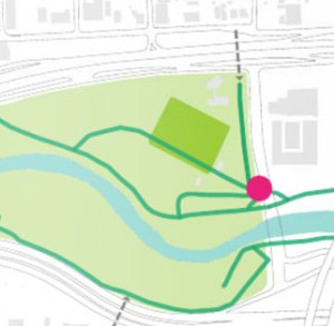
The kelley green box on the map above shows the cistern’s buried footprint on the north shore of Buffalo Bayou (in blue), just west of Sabine St. and south of Memorial Dr.; the darker green line passing through the southwest edge of the cistern shows a plan to run the bayou’s bike trail into the cistern and onto a suspended causeway:
Underwater Underground

Update, 3/24: BBP has updated the link to and language of the job posting; this story has been updated.
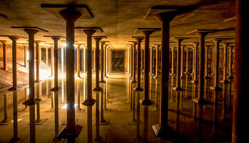
Wanted: Buffalo Bayou Partnership is seeking some college types folks to show people around the long-empty city drinking water reservoir near the intersection of Sabine St. and Memorial Dr., which the group also hopes to turn into a temporary art space some day. The “accidental cathedral” was only accessible by a set of hatches and 14-foot ladders back when BBP first examined it; a $1.2-million grant is being used to bring the 87,200-sq.-ft. underground space up to code for visitors.
The cistern, nicknamed after the 6th-century reservoir beneath Istanbul, lies just north of the Lee and Joe Jamail Skate Park beneath what will become a raised outdoor lawn intended for concerts and events at Buffalo Bayou Park. The 1927 reservoir was drained and decommissioned decades ago after it started leaking uncontrollably; the structure was planned for demolition and fill-in by the city around the time the park’s planners took an interest in the space, initially imagining uses like parking and mulch storage.
Work in the Underground

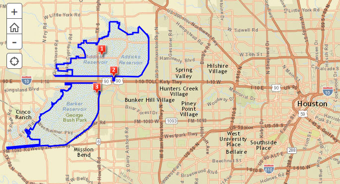
The Army Corps of Engineers is holding a public meeting amid this evening’s predicted thunderstorms to chat about the recently begun replacement work on the Addicks and Barker dams, which have each won the rare and highly distinguished label ‘extremely high risk’ through a combination of structural issues and close proximity to Houston. For those not planning to flood the Corps with questions and comments in person, there’s a somewhat-outdated online survey, as well as an online map of updates on the project’s progress. Work to replace the outlet structures of the dams began in February, and is expected to take about 4 years.Â
The 2 reservoirs, spread out across 26,000 acres on either side of the Katy Fwy. near Highway 6, starred in the Sierra Club’s 2011 lawsuit over the construction of Segment E of the Grand Parkway through the reservoirs’ catchment area. The club claimed development spurred by the road could send major additional runoff to the reservoirs, increasing the chance of dam failure, which Dave Fehling of Houston Public Media reports “could do an estimated $60 billion dollars in damage to downtown Houston, to industries along the Houston Ship Channel, [and] even to the Texas Medical Center.” The judge didn’t stop construction of Segment E, but did order new studies on its potential flooding impacts.
Addicks and Barker Reservoirs

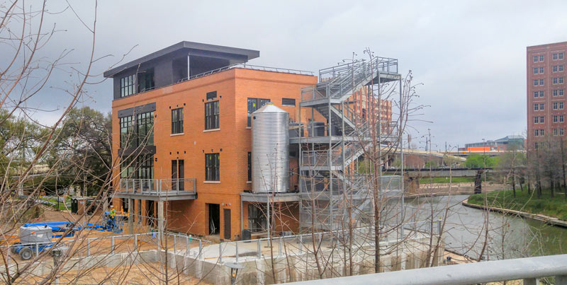
A shiny new cistern is now in place at the former Sunset Coffee building at Allen’s Landing, which Buffalo Bayou Partnership and Houston First have been redeveloping into an office-topped boat-and-bike-rental spot. The 1910 coffee roasting facility has once again donned walls after moving past a Summer 2014 minimalist phase, and is currently decked out in a muted Café du Monde orange.
The no-longer-see-through structure is back to limiting the view from the Harris County Jail across the bayou (visible on the far right, above). A set of stairs are in place alongside the new cistern, along with railings around what appears to be the planned rooftop terrace.
Nearing Launch at Allen’s Landing


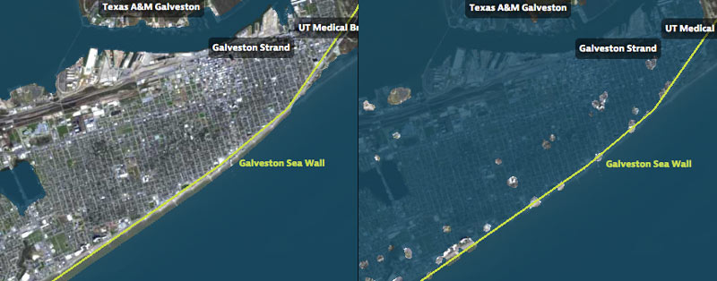
That’s Galveston Island going for a dip in the before-and-after captures above, from a set of interactive timelapse maps released by the Texas Tribune and ProPublica yesterday (along with several articles by authors Kiah Collier and Neena Satija). The new maps model flooding across the Houston region during Hurricane Ike — as well as what would have happened if Ike had actually hit just south of Houston, as meteorologists initially expected.
The maps are your chance to relive an old disaster, or to see how many of your neighbors you can take out with a hypothetical-but-not-unrealistic future storm: users can pick between Ike, south-er Ike, a storm 15% stronger than Ike (nicknamed Mighty Ike), and a modeled 500-year storm (which the article suggests may actually be a concern on the every-few-decades-or-so level; ‘500-year’ has always meant ‘a low probability in any year’, and climate change is shaking up old modeling assumptions). The graphics also include a few dramatic face-offs:Â Mighty Ike and the 500-year storm VS. 2 of the miles-long multi-billion-dollar coastal protection projects being studied for the upper Texas coast.
You can even search for your home address in the map system to see what flood levels might look like in your own back yard. Here’s what the maps show happening to the Clear Lake, Seabrook, and League City areas at the peak of the 500-year storm model’s storm surge, which the article says is a “not if, but when” event:
Hell and High Water

CELEBRATING LAURA DAY, AND THE CON THAT MADE THE CITY 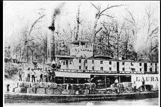 On this day in 1837 — according to Houstorian, Houston’s “loudest preservation group” — the packet steamer Laura shoved its way up Buffalo Bayou through sand bars and tortuous snags to Allen’s Landing in what is now Downtown Houston. The trip proved publicly for the first time that such a voyage was actually possible, though the Allen Brothers had already been promising as much to investors for months in their “highly exaggerated” advertisements of the new town. Houstorian teamed up with the Bayou Preservation Association last night to celebrate the grand con’s success; the now-annual Laura Day event took place this year at Public Services Wine & Whisky, housed in the 1884 Cotton Exchange Building at the corner of Travis and Franklin — just a few blocks west of the Laura’s purported landing site at the foot of Main St. [Houstorian] Historic photo of the steamship Laura: Houstorian

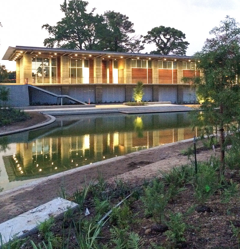
 A reader sends pics of 3 notable new features near the western end of Buffalo Bayou Park that appear to be just about complete: The multi-purpose private event space known as The Dunlavy, overlooking a restored and upgraded pond now called Lost Lake — and its signature central feature, a bell-mouth spillway to suck up the overflow, referred to more commonly as a morning glory. That’s the hole in the middle of the water feature; if you look closely at the photos of it below you can see the odd sight of the tip of a construction ladder peeking out at the top:
And the Dunlavy, Almost Done

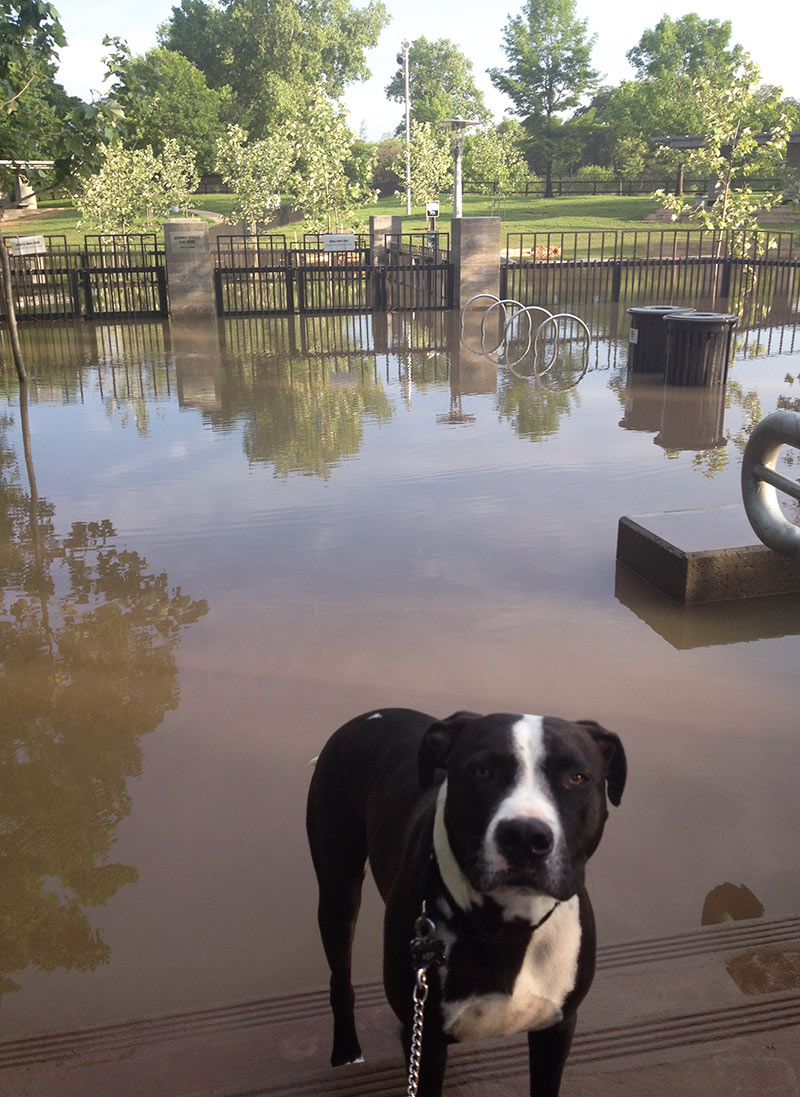
No Buffalo Bayou Park fun this morning for Swamplot coverdog Kep, on account of the whole Johnny Steele Dog Park at the intersection of Studemont and Allen Pkwy. is flooded after yesterday’s downpours. Which is what a bayou-side park is expected to do during and after weather like yesterday’s.
More pics of the scene:
When Buffalo Bayou Spreads

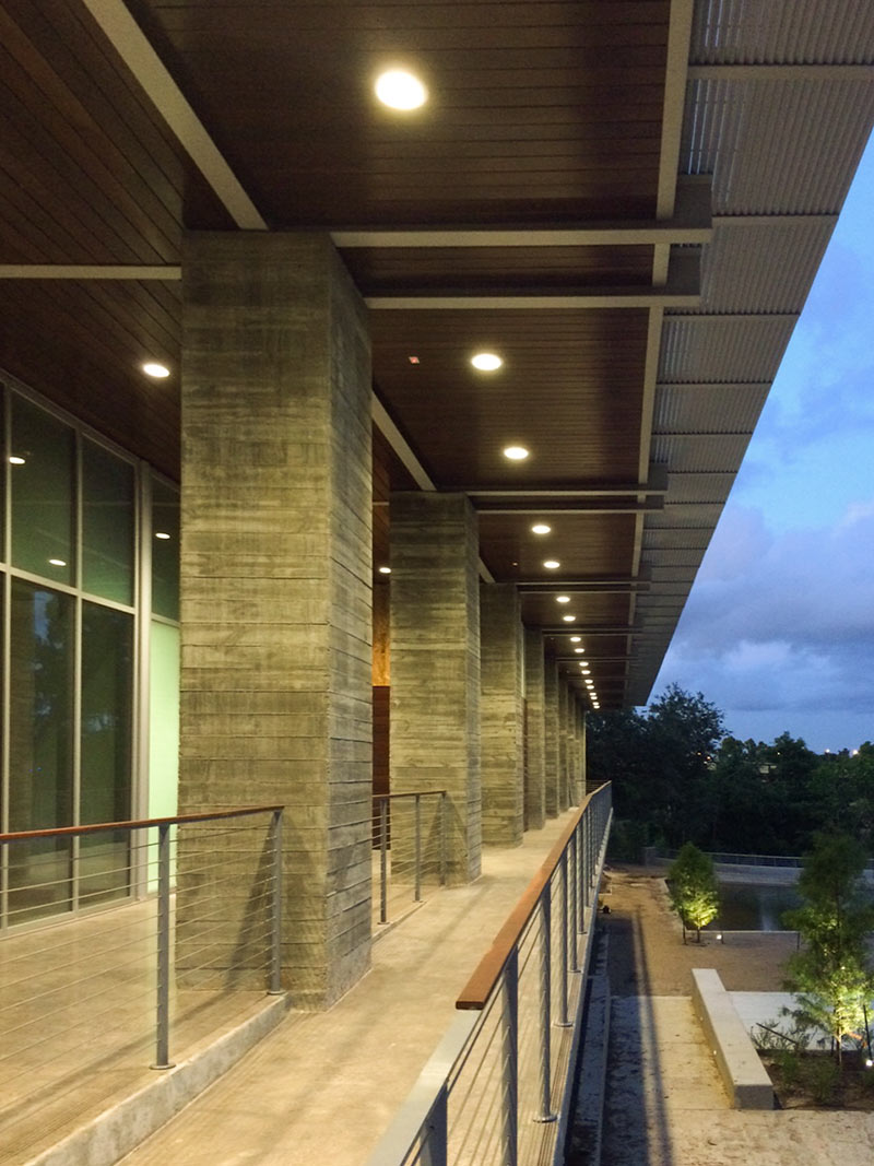
Here’s a photo from earlier this month showing construction progress on the new Wortham Insurance Visitors Center on Sabine St., fronting the “Waterworks” area of the ever-expanding Buffalo Bayou Park complex. When it’s complete — sometime this summer — the 2,736-sq.-ft. building will house an info desk, a bike-rental facility, and — yes — restrooms. A terrace on top will be available for special events. A gaggle of insurance companies led by Wortham Insurance donated $750K toward the building’s more-than-$1-million construction cost.
The building, designed by Page — the same firm responsible for the buildings on Discovery Green — is meant to serve as the “primary gateway” to Buffalo Bayou Park, including these surrounding features:
Same Wortham, Different Center

How long has it been since you’ve run along, rowed along, or flown over Buffalo Bayou? Guy-out-with-his-Phantom-quadcopter Marco Luzuriaga filmed this scene earlier this month above a short section of the city’s most prominent drainage canal beginning near the Rosemont Bridge, then turning around and heading a ways toward Downtown. He gives up on the waterway and substitutes a bit of downtown-tangling freeway spaghetti near the end, but if you look into the distance around the 1:30 mark, you can catch a quick progress report on reconstruction of Buffalo Bayou Park.
Video: Marco Luzuriaga, via Brittanie Shey
Tour by Drone
