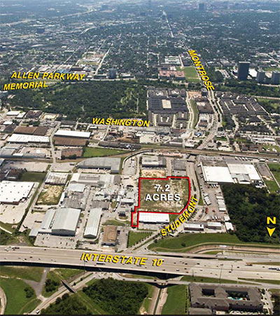
STUDEMONT KROGER AIMS FOR A CITY TAX DEAL A couple of news bits about the new grocery store Kroger is planning for an 8.5-acre site it purchased in February at 1400 Studemont, just south of I-10 and just north of the Arne’s Warehouse and Party Store: It’ll measure 79,000 sq. ft., and will have a gas station. Plus, Chris Moran reports, Houston’s city council will consider sales and property tax reimbursements to the company of as much as $2.5 million. The proposed deal would require the company to create 170 jobs at the location for 13 years and donate $40,000 for improvements to Olivewood Cemetery across the street. [Houston Politics; previously on Swamplot]
Tag: Industrial Areas

Kroger has bought 8.5 acres of former industrial land on Studemont, just south of I-10, the Chronicle‘s Purva Patel reports. The land, which was once part of Houston’s Sixth Ward, sits just north of Arne’s Warehouse and Party Store and across the street from Grocers Supply. Kroger closed on the larger portion — a 7.2-acre cleared parcel at 1400 Studewood, listed for sale at $15.7 million — just last week. A spokesperson for the grocery chain wasn’t ready to announce a new store on the site, but did say the company had already taken possession of 1.3 acres just to the south, at 1200 Givens St. If Kroger does build a new supermarket there, the parking lot would have 450 ft. of frontage on Studemont; other industrial properties, many of them accessed from Summer St., would still be sandwiched between it and the Sawyer Heights Target.

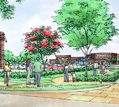
Just ahead of tonight’s meeting, Ainbinder Company has released the requisite mostly-empty-parking-lot and pedestrians-standing-in-a-median renderings of the Walmart the company is hoping to seat off Koehler and Yale in the West End. The renderings come from a 5-page brochure for the company’s Washington Heights development that includes an aerial view and plenty of lovely images documenting the site’s industrial recent past, going so far as to call the former Trinity Industries plant on the site — where beams, columns, and other structures were fabricated from supplied raw materials — a “steel mill.” But no official (or updated) site plans for the current proposal are included.
Here’s a view of how the Walmart might look in the early dawn, as you drive up:

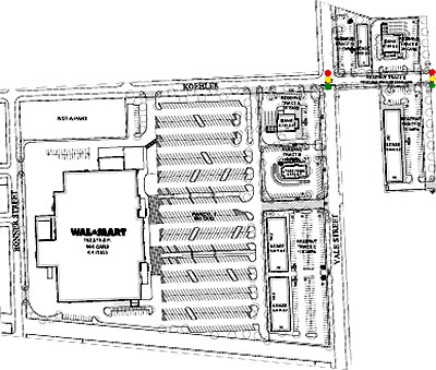
Walmart has not completed its purchase of 15 acres of the former Trinity Industries steel fabrication site on Yale St. just south of I-10 and the Heights, but an executive with the Ainbinder Company, which has owned the property for 3 years, has been quoted as saying it is no longer negotiating with any other potential buyers (H-E-B was one), and that the deal should be complete within a few weeks. A site plan obtained by the Chronicle‘s Nancy Sarnoff shows 2 bank-style pad sites and a park-in-front strip center facing Yale, in front of the 152,000-sq.-ft. Walmart’s 664-car parking lot. Also shown in that plan, as part of the proposed development: a sprawlerrific future for the current site of the Heights Plaza Apartments to the northeast of the site, featuring a strip center along Heights Blvd. and a “bank” site just to the north, at the southern edge of White Oak Bayou. Yet another strip center is shown on the back side of the bank site, facing Yale St. to the west.
Ainbinder has the Heights Plaza Apartments at 205 Heights Blvd. under contract. Speaking at a meeting organized by city council member Ed Gonzalez, Michael Ainbinder said he expects to close on that property this fall and include the land in the retail development, bringing its total land area to 24 acres. Nicgk, who took extensive notes on the meeting and included them in his blog, They Are Building a Wal-Mart on My Street, reports that the developers are claiming that the development will not be “a ‘typical suburban’ project.” Nicgk reports an Ainbinder representative noted the
‘warehouse’ type of architecture; they noted the ‘Core’ apartments, and ‘Berger Iron Works’ on the corner plot of land. They intend to keep that type of neighborhood feel to the development
-It was described as a more modern warehouse/urban type of feel . . . Ainbinder assured that the infrastructure of the land, and surrounding, would be brought up to appropriate specs to support.
Below: a few photos of the site from a larger set and scouting report by another neighborhood blogger, Charles Kuffner.

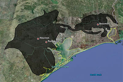
Playing around with a super-fun online tool that lets you superimpose the blobbish outline of the 2500-sq.-mile (and growing!) Gulf of Mexico oil slick from the Deepwater Horizon offshore-rig disaster onto various cities, Houstonist editor Marc Brubaker tries it on Houston — for size.
“It’s almost creepy how the slick follows I-10 out to Beaumont,” he comments. Of course, Brubaker should have nudged the oily blob a bit more to the east. Sure, he might have lost a few of those shiny exploration-company offices that have fled to the western stretches of Katy that way, but you’d be picking up lots of fun storage tanks and chug-chugging industrial plants at the northern reaches of Galveston Bay, and you’d get better coverage of Texas City, too.
Oh — but the outline is only up to date as of May 6th? Maybe we’ve got full coverage by now, then!
- Slicky Situation: The Deepwater Horizon Spill’s Actual Size [Houstonist]
- How big is the Deepwater Horizon oil spill? [Paul Rademacher]
Image: Houstonist
Ready, at last, for the small screen: This lingering aerial tour of Houston’s rich natural and nature-processing landscape, straight from last year’s Center for Land Use Interpretation exhibit on Texas Oil.
Put on your headphones, turn up the volume, and take it all in!
Our journey takes us east from the 610 Loop and ends at the liftoff point for the Fred Hartman Bridge at Highway 146. When they gonna come back and give us some Baytown?
- Houston Petrochemical Corridor Landscan [Vimeo]
- Texas Oil: Landscape of an Industry [Blaffer Gallery]
- Previously on Swamplot: CLUI in Houston: Attack of the Pod People, CLUI Houston Residency: Open to Interpretation
Video: CLUI
And now, a rare look at the Second Ward’s indigenous Ship Channel dance ceremony, performed along the gentle banks of Buffalo Bayou and celebrating the bountiful fall harvest of crushed concrete.
- Tetsujin [Vimeo]
Video: Freneticore
CEDAR BAYOU AIR UPSETS The Sierra Club and a Texas environmental group have filed suit against Chevron Phillips claiming a bonus supply of air pollutants and toxic chemicals has been escaping from the company’s Cedar Bayou chemical plant just north of I-10 in Baytown: “‘Like many companies in Texas, Chevron Phillips has repeatedly violated its own permit limits by emitting a wide range of harmful pollutants into the air from the Cedar Bayou plant,’ said Luke Metzger, Director of Environment Texas. ‘Because the state of Texas has failed to stop such violations at Cedar Bayou and elsewhere, citizen groups have had to step up and enforce the law themselves.’ The Clean Air Act contains a ‘citizen suit’ provision that allows private citizens affected by violations of the law to bring an enforcement suit in federal court if state and federal regulators do not. . . . Chevron Phillips’s permits contain both hourly and yearly limits on the amounts of pollutants it can emit into the atmosphere. The lawsuit alleges that equipment breakdowns, malfunctions, and other non-routine incidents at the Cedar Bayou complex have resulted in the release of more than a million pounds of pollutants into the surrounding air, frequently in violation of legal limits. A single such ‘upset’ or ’emission event’ can result in the release of tens of thousands of pounds of air pollutants in a matter of hours or even minutes.” [Environment Texas, via Houston Chronicle]
Houston ship pilot Louis Vest assembled this video from more than 2000 still photos he took on a 3 1/2-hour journey on a 600-ft.-long Panamax tanker navigating the Houston Ship Channel:
The ship was only moving at 5-6 knots for the first half of the trip and up to 10 knots in the open areas away from the docks. The journey begins just below the Port of Houston turning basin at the end of the channel and continues down to Morgan’s Point at the head of Galveston Bay. We still had 32 miles to go to get out to the pilot station in the Gulf of Mexico at that point.
Vest fastened his Nikon D700 to an outside rail and set it to take a photo every 6 seconds.
What does this trip look like in the daytime? Vest made a similar video last year (high-res version).
- Night Run II [YouTube, via Houstonist]
- Night Run II, 1st Half [Flickr]
- 500 Knots on the Houston Ship Channel [Flickr]
If, for some reason, buyers are still interested in new inner-loop townhomes perched on former industrial sites a few years from now, Mir Azizi will be well situated. The townhome and Herrin Lofts developer is the proud new owner of a now apparently doomed 279,400-square-foot warehouse in the industrial area north of Memorial Park, just west of the occasionally lapping waters of White Oak Bayou.
“He’s thinking perhaps it will be a future town home development, but isn’t deciding right now,” the listing broker told GlobeSt.com.
- First Industrial Sheds 455,707-SF Pair [Globe St.]

