EPA: YEAH, BETTER CLEAN OUT THE DIOXIN PITS FROM THE SAN JACINTO RIVER NOW THAT THEY’VE LEAKED A bit later than had been urged by those alarmed by the longterm presence of pits full of toxic waste sealed only with a tarp on top hanging out in the San Jacinto River, the EPA has now approved a plan to remove most of the dioxin stored within them. “As exemplified today, EPA is prioritizing Superfund clean-up by making decisions in a decisive, timely manner,” reads a statement from administrator Scott Pruitt released this afternoon. “The San Jacinto Waste Pits site was added to the National Priority List nearly a decade ago.” What’s the rush? As predicted by EPA studies and many a casual observer, the pits appeared to have leaked extensively after Hurricane Harvey flooding. Under the new $115 million plan, cofferdams will be installed around the pits and almost 212,000 cubic yards of dioxin-contaminated material will be excavated — leaving just enough behind that the agency can, it says, ensure controls that will “prevent access, eliminate off-site migration, and monitor the natural recovery into the future.” [EPA; more info; Houston Chronicle; previously on Swamplot] Video of waste pits after Harvey flooding: Greg Moss
Tag: San Jacinto River
Weather permitting, an area along the edge of the San Jacinto Waste Pits Superfund site under the I-10 East bridge should be getting around 800 cubic feet of new rocks piled onto it this week and next, according to this month’s EPA update on the project. The agency asked International Paper and McGinnis (which might be on the hook financially for much of the final cleanup) to cover up some recently-discovered areas of the nearby riverbed that were scoured as deep as 8 feet in some places by this spring‘s torrential flooding; the tarp-with-rocks-on-it armored cap itself doesn’t appear to have been damaged, but the EPA says the extra rocks will help ensure its continued protectiveness.
COMMENT OF THE DAY: YOU CAN LOVE THE BAY YOU’RE WITH AND STILL HARBOR SHIP CHANNEL FANTASIES  “I know that Galveston Bay is the economic engine of the Houston area, but it’s fun to ponder what 42 prime bayside acres could be other than a barge staging area, or what the bay woulda/coulda been had oil not been discovered nearby. Coulda been San Francisco, got Can Cerisco.” [JoeDirt, commenting on Kirby To Lease New Ship Channel Barge Parking Area, Pay for Barge Collision Oil Spill] Illustration: Lulu
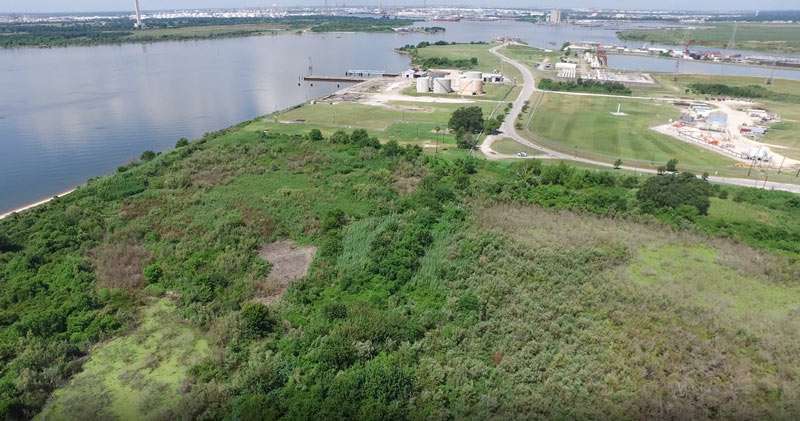
Some of the 42 acres of land just purchased for development by Avera Companies are shown here from above, east across the Ship Channel from the San Jacinto Battleground (that’s the bottom half of the star-topped obelisk visible toward the top left).  The property is on a peninsula of land about 2 miles downstream from the I-10 bridge and the San Jacinto Waste Pits. The eastern terminal of the Lynchburg Ferry can be seen here at the end of Independence Highway, with the Lynchburg reservoir lying  to the north.
The company says Kirby Inland Marine is set to be the first tenant for the property, and will use a section of the property to let up to 76 barges tie up and hang out as necessary. Kirby just agreed last month to a $4.9-million settlement with the Department of Justice over its role in that March 2014 barge-meets-carrier oil spill that shut down the Port for a few days and spread oil along roughly 160 miles of Texas coast between Galveston Bay and Padre Island National Seashore. (Kirby Offshore Marine, another of the corporation’s subdivisions, is currently dealing with fallout from last week’s tugboat-meets-shore fuel spill off the coast of British Columbia.)
Here’s a view of the rest of the property, showing a bit of Burnet Bay on the left and the San Jacinto River upstream toward I-10 on the right:
YOU MIGHT WANT TO TAKE THAT DIOXIN OUT OF THE SAN JACINTO BEFORE A HURRICANE DOES IT FIRST 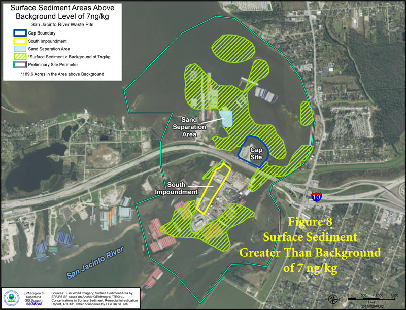 Yesterday marked the start of the 60-day public comment period on this week’s proposal to pull about 202,000 cubic yards of dioxin-laced muck out of the San Jacinto River near I-10. The Houston Chronicle editorial board was among the first to jump in (though not through official comment channels), highlighting the EPA’s conclusion that the waste, which has already been seasoning the seafood and (potentially) the river’s swimmers and nearby residents since the 1960s, could cause much larger problems if the wrong storm or hurricane hits the site; the board also calls out International Paper and Waste-Management-affiliated McGinnis Industrial Maintenance — companies potentially on the hook for the cleanup bill — for purportedly slowing down the cleanup process. [Houston Chronicle; previously on Swamplot] Map of higher-than-background dioxin levels near San Jacinto Waste Pits site at I-10: EPA

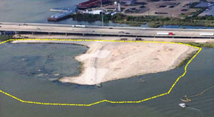 Yesterday the EPA released their recommendations for what to do about the toxic muck in the San Jacinto Waste Pits, after more than a decade of local and federal agencies poking and fishing around in the area (on either side of the I-10 crossing of the river). So far the Superfund site has been temporarily dealt with by the 2011 placement of a pretty-much-just-a-tarp-with-rocks-over-it armored cap, which the EPA says has already been repaired at least 7 times; the document released yesterday notes, however, that disturbances at the site caused by weather and previous nearby sand mining operations “could cause a catastrophic release of the highly toxic waste materials from the impoundments, if they remain in place.”
The EPA wants to remove about 202,000 cubic yards of contaminated material (roughly enough to fill the floor of the Astrodome with a 13-foot-deep layer) but says it’ll have to be done carefully so as not to accidentally stir up the waste into the surrounding river while trying to get it out; the removal would also probably take place in stages to avoid potentially exposing too much of the waste at a time to storms or flooding. Here’s the EPA’s map of the 2 sites where the paper sludge was originally dumped in the 1960s — the (capped) northern area is outlined in blue and labeled Cap Site, while the southern site (outlined in yellow and labled Southern Impoundment) is covered in part by the Glendale Boatworks building, next to Southwest Shipyard:

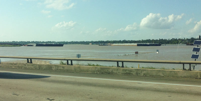
 Another effect of the Memorial Day weekend and early June floods: the EPA says it has had to pause some of its latest study efforts near the 1960s industrial waste pits in the San Jacinto river (shown at the top looking a bit more submerged than usual on May 31, facing north from the I-10 bridge). New rounds of sample-taking were triggered by the discovery in December that the Superfund site’s armored cap (which is made of special tarp material held down by a layer of rocks) had a 25-ft.-long hole where the rocks were missing. The EPA also notes that the damage was found within an area of the cap where no tarp was actually initially placed, in light of concerns that the rocks would slide off of it.Â
GROUP FORMS TO CLEAN UP THE UPPER SAN JACINTO BEFORE IT GETS AS BAD AS BRAYS, BUFFALO, SIMS BAYOUS 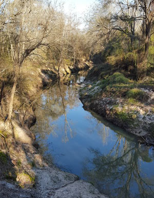 The West Fork of the San Jacinto River (implicated in much of the latest flooding between The Woodlands and Conroe) is in a bacterial “sweet spot”, environmental planner Justin Bower tells Matthew Tresaugue in the Houston Chronicle this week  — more contaminated than is acceptable, Bower says, “but not so much that we can’t do anything about it.” Tresaugue writes that E. coli levels have been trending upward since 2002, in some cases running as high as 10,000 colonies per 100 milliters of water (around 80 times higher than the 126-colony limit recommended by the state of Texas). The river’s water quality problems are multifaceted, but generally boil down to increased development in the watershed causing increased runoff that carries more junk — from human and animals waste to sediment from a nearby gravel mining operation — into the river and ultimately the Lake Houston reservoir (from which the city pulls drinking water). The newly formed West Fork Watershed Partnership has no definite plan yet (other than to work with area stakeholders to develop a plan). But Lisa Gonzalez (VP of the Houston Area Research Council) notes to Tresaugue that not doing anything could allow the West Fork’s water problems to get as bad as those of other major urban waterways in Houston. [Houston Chronicle; previously on Swamplot] Photo of West Fork of the San Jacinto: West Fork Watershed Partnership

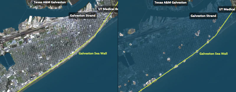
That’s Galveston Island going for a dip in the before-and-after captures above, from a set of interactive timelapse maps released by the Texas Tribune and ProPublica yesterday (along with several articles by authors Kiah Collier and Neena Satija). The new maps model flooding across the Houston region during Hurricane Ike — as well as what would have happened if Ike had actually hit just south of Houston, as meteorologists initially expected.
The maps are your chance to relive an old disaster, or to see how many of your neighbors you can take out with a hypothetical-but-not-unrealistic future storm: users can pick between Ike, south-er Ike, a storm 15% stronger than Ike (nicknamed Mighty Ike), and a modeled 500-year storm (which the article suggests may actually be a concern on the every-few-decades-or-so level; ‘500-year’ has always meant ‘a low probability in any year’, and climate change is shaking up old modeling assumptions). The graphics also include a few dramatic face-offs:Â Mighty Ike and the 500-year storm VS. 2 of the miles-long multi-billion-dollar coastal protection projects being studied for the upper Texas coast.
You can even search for your home address in the map system to see what flood levels might look like in your own back yard. Here’s what the maps show happening to the Clear Lake, Seabrook, and League City areas at the peak of the 500-year storm model’s storm surge, which the article says is a “not if, but when” event:
HOW TO PREPARE SAN JAC RIVER STEW What’s the local recipe for that San Jacinto River fishin’ favorite, toxic redfish? “The dioxins come from submerged waste pits north of the Interstate 10 bridge. McGinnes Industrial Maintenance Corp., which is no longer in business, owned and operated the pits in the 1960s, filling a 20-acre site on dry land with waste from a now-closed paper mill near the Washburn Tunnel. In the bleaching process, paper mills generated large amounts of dioxins, a family of compounds so toxic that scientists measure them in trillionths of a gram. The EPA says there is no safe level of exposure to the chemicals, which are known to cause cancer and disrupt immune and reproductive systems. The San Jacinto River began to run through the waste pits by the early 1970s because of subsidence — the sinking of soft soils as water is pumped from underground. With the McGinnes pits under water, the dioxins spread into the river and worked their way through the ecosystem, becoming more concentrated at each step in the food chain. For more than a decade, the Texas Department of Health has warned that fish and crab caught along this stretch of water, north of the Lynchburg Ferry, are tainted with cancer-causing dioxin, pesticides and PCBs. . . . In July, the EPA identified the International Paper Co. and McGinnes, which became part of Waste Management through a series of mergers and acquisitions, as the firms responsible for the dioxins problem. Under the Superfund law, the two companies will be required to evaluate and clean up the contamination. They paid about $65,000 for the fencing and roughly 50 warning signs in English, Spanish and Vietnamese, a McGinnes spokesman said.” [Houston Chronicle]

How best to describe this unique home? We’ll give it a stab: Elegant, modern, cathedral-like little 6-bedroom, 8-1/2-bath getaway on the right bank of the sometime-fiery San Jacinto River in Highlands. Interior rock waterfall at entry, park-like 2.3-acre setting bounded by small creek. Floor-to-ceiling windows bring in plenty of light and refined air. Pink Kitchen with circular island. Just Minutes north of the Lynchburg Ferry. Built in 1972.
And the price for all this fabulousness?

