COMMENT OF THE DAY: WHY THINGS LITERALLY LOOK BRIGHTER ON HOUSTON’S HORIZONS  “Actually, Houston has substantially improved both air and water quality in the past few decades. I remember the haze days back in the early 90’s when you could not see more than a few miles through the smog when driving down the Katy Freeway, nor could you see the tops of the taller buildings. Also, nearly all of the illegal water pollution sources have been permitted and/or rerouted into treatment systems. The ones that haven’t are eventually caught and have to pay hefty fines, or the responsible people go to jail. It is true that much of the improvement was driven by federal and state regulation that trickled down to Houston, but that is true for most major cities.” [Superdave, commenting on Comment of the Day: Making Sure the House Wins Houston’s Toxicity Gamble] Illustration: Lulu
Sign up for the Newsletter
Tag: Pollution

COMMENT OF THE DAY: MAKING SURE THE HOUSE WINS HOUSTON’S TOXICITY GAMBLE  “Its very clear that the east side of town has the largest concentration of known pollution release points (permitted and otherwise). However, you can also easily see that there are corridors extending to the north, northwest, and south. They follow the most active freight rail lines, and the heavy industry that got built up all around them. And then there’s hazmat stuff like this, which can be located basically in any warehouse, office warehouse, distribution center, or manufacturing facility in any part of town — and it won’t get onto the map. (Remember the explosion in West, TX? Not gonna be on the map.)  . . . If you want the best odds on avoiding all that stuff, then find yourself a relatively new neighborhood that was built as greenfield development, check historical imagery on Google Earth to confirm what was there previously, buy a house in the interior of it, and be sure that you’re getting your water from a large, well-run water system. You should never drive into the city for any sort of business, civic, or educational function without donning a gas mask, and you should bring bottled water from home. Or you could just accept that there are some risks in life and balance them with the things you value — whatever that may be.” [TheNiche, commenting on That Blood Red Stuff in the Bayou May Not Be Spring Branch’s Biggest Problem Right Now] Map of Houston area Superfund sites: EPA Enviromapper

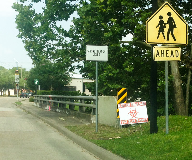
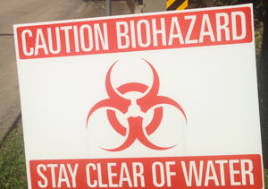
The latest addition to the growing collection of signage at the Westview Dr. crossing of Spring Branch: a shiny new stick-in-your-yard-style biohazard warning sign, one of a number that popped up over the weekend along stretches of the creek that got the full vermillion treatment after last week’s chemical-fueled warehouse fire about a mile upstream. The newcomer joins the inveterate kiddo-crossing and school-zone signs tipping off drivers to the proximity of both Moritz Pech Family Park and Valley Oaks Elementary School, along with a Keep Spring Branch Clean & Green! anti-litter placard and a vintage No Dumping $200 Fine.
Other indicators of last week’s spill include the multi-colored booms still strung across the waterway (shown here looking south):
Trickling Through the Memorial Villages

GOOD THING SPRING BRANCH HAD ALL THAT FLOODING LAST MONTH 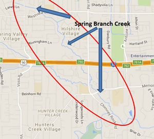 A press release from the city notes that last month’s flooding may actually make the chemical spill caused by yesterday’s warehouse fire significantly less of a problem for the waterways around Spring Branch: “Fortunately, recent heavy rainfall and flooding has caused high waters in our creeks and bayous. This will assist in diluting the pesticide contaminates and minimize its impact.” Harris County Flood Control District says the areas of Spring Branch creek marked in the map above (from the site of the fire to the creek’s junction with Buffalo Bayou) should be avoided. [City of Houston; previously on Swamplot] Image: Harris County Flood Control District

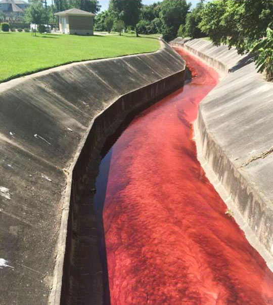
The ditches ran red in the Spring Branch area yesterday as the billowing 4-alarm fire near Laverne St. at Spring Branch Dr. triggered evacuations and shelter-in-place orders across the surrounding areas. The blaze reportedly started in a home-slash-auto-shop on Laverne and spread next door to the A-1 Custom Packaging warehouse (which transfers large quantities of various industrial liquids into smaller bottles for distribution). Some of those stored chemicals (including the bright red petroleum additive visible in the shot above) made their way into drainage ditches and culverts flowing into Spring Branch itself.
The red additive is non-water-soluble and has been getting pushed around by contract clean-up crews downstream to stop the spread. But contractors cannot, the city says, catch the pesticide that also made its way into the same drainage channels, as it dissolves in water. It’s still unclear how much of the 500 gallons or so thought to have been stored at the site made it all the way into Spring Branch (which flows into Buffalo Bayou south of I-10), but some water quality test results are due back later today.
River Running Red

COMMENT OF THE DAY: BOTH OPTIONS FOR DEALING WITH RUN-OF-THE-MILL HOUSTON TOXICITY  “My wife, until last May, worked at a school very close to this (but [which] was not mentioned). The air pollution on normal days is so bad that my wife’s doctor suggested that if we wanted to have children that she should think about changing jobs.  . . .  Attention is only drawn to the problem when major events happen — but perhaps long term effects of living and working in the area are greater ([and] simply tolerated as business as usual). I have said it before, but it is worth mentioning: I called the TCEQ and many agencies during my wife’s time working over there about the pollution . . .  they informed me that the area has regularly violated EPA standards and my only option was to ‘vote for people who care about government regulation’ of said pollution. Sounds like a tough project!” [Anon, commenting on This Morning’s LyondellBasell Refinery Fire Put Out 19 Hours after Yesterday’s ExxonMobil Refinery Fire] Illustration: Lulu

COMMENT OF THE DAY: THE JOBS WILL GO WHEREVER THE WIND BLOWS THEM  “I think it has less to do with the location of high-paying jobs, and more [to do with] proximity to the Ship Channel and its pollution. If you look at wind pattern maps, all the historically least-desirable areas are where prevailing winds off the coast end up tending to blow pollution originating from the Ship Channel. The high-income jobs are located west of downtown because that’s where the high-income people wanted to live, not the other way around. This isn’t specific to Houston, either – the west side of most North American cities tends to be the more desirable side, owing to prevailing winds and the location of dirty industrial areas. Chicago is an excellent example — the south side being less desirable owing to its location downwind (south and east) of the massive stockyards that existed there a century ago.” [TMR, commenting on Comment of the Day: Breaking the Cyclical Expansion of the Donut of Despair] Illustration: Lulu

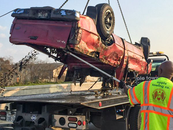
If you are the owner of the bottom half of a red Ford Ranger left in Brays Bayou near Wayside Dr. some time in the last 20 years, your vehicle may be waiting for you in HPD’s impound lot. The pilot program intended to test out a procedure for fishing out the 127-or-so vehicles mapped beneath the surface of a few of Houston’s waterways reeled in its 20th and final car over the weekend before the $49,500 project grant ran out.
The removals started near the Wayside bridge over Brays Bayou in late January, then moved upstream of the crossing of Lidstone St. on the 29th; last Friday, operations jumped down to Sims Bayou to score a few final sets of wheels. Harris County Flood Control District, which oversaw the fishing trips, tweeted that project executives will now meet to discuss future removal plans and compare notes on the process, which involved divers from Saltwater Salvage submerging to attach giant yellow floaties to the sunken vehicles:
Stirring Up Mud in Gulfgate

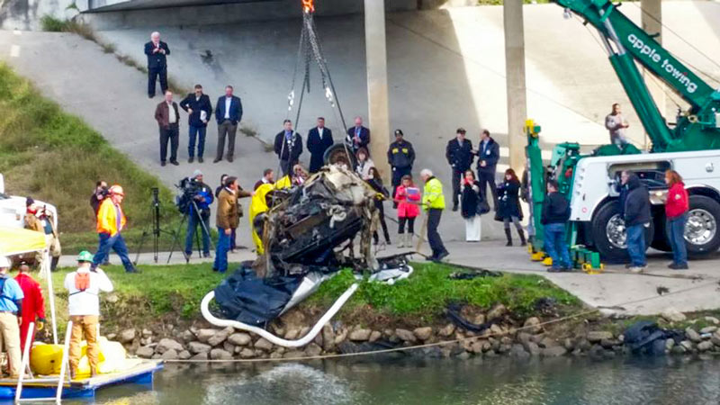
A 1987 Buick Regal was pulled from Brays Bayou yesterday, as a $49,500 pilot program to remove about 127 vehicles thought to be sunk along the bottom of several of Houston’s major bayous revved up. Divers working at the crossing of S. Wayside Dr. attached bright yellow floaties to the sedan to help it swim to the surface before it was lifted onto the shore, where police identified it as reported stolen in 1998. Mike Talbott of the Harris County Flood Control District expects that crews will be able to remove some 20 to 25 cars before the money runs out.
The Buick is one of the drowned cars mapped by Texas Equusearch in 2011, as the nonprofit used a sonar-equipped boat to look for a missing woman in a Black Dodge Avenger (later found in a retention pond off Old Galveston Rd.). Assistant Chief Mark Curran of HPD told ABC 13 that most of the cars at the bottom of Brays and Sims Bayous were probably joyridden and then dumped. Stolen vehicles have been found in other Houston-area water bodies, including that 1985 Fiero uncovered in 2011 during the extended drought which brought down Lake Houston water levels.
Floating yellow containment booms spanned the waterway downstream of yesterday morning’s operation to catch any oil or gasoline that might leak from the vehicles during the removal process:
Nice Catch Under Wayside Dr.

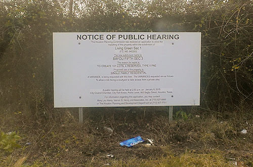
Signs have gone up around the former metal foundry site at 3617 Baer St. in the Fifth Ward indicating that a hearing is scheduled for this Thursday to get city approval for the latest rejiggering of homesites on the 35-acre tract. Developer Frank Liu of Lovett Homes, InTown Homes, and a few other local builder brands plans to put a total of 538 homes (down from 589) on the EPA-monitored property, known as the MDI Superfund Site after the last owner of the metal-casting operations, Many Diversified Interests, which shut down in the early 1990s (previously, the plants were owned by TESCO). The property, which lies just south of I-10 about 2 miles of east of downtown, was listed on the EPA’s list of priority Superfund sites in 1999, after tests showed the soil and groundwater was contaminated with lead and other hazardous metals.
Living Green

COMMENT OF THE DAY: WHY IS ANYONE LIVING THAT CLOSE TO A REFINERY?  “Tax policy should probably discourage residential habitation in neighborhoods near the Houston Ship Channel and encourage people to move away from them. As such, giving existing residents or residential property owners a tax cut in order to reward them for residing there or maintaining and leasing housing to other people would be extraordinarily counterproductive and stupid.
Manchester in particular is a neighborhood where the City or State government should seriously consider its options with respect to eminent domain. There’s nothing quite like it anywhere else in the region. Even the furthest north residential bits and pieces of Pasadena are better isolated from refinery activities and more integrated into their city than is Manchester.” [TheNiche, commenting on Baytown Buc-ee’s Is Here; Goodbye Mission Burrito, Hello Ãœberrito Mexican Grill] Illustration: Lulu
“Tax policy should probably discourage residential habitation in neighborhoods near the Houston Ship Channel and encourage people to move away from them. As such, giving existing residents or residential property owners a tax cut in order to reward them for residing there or maintaining and leasing housing to other people would be extraordinarily counterproductive and stupid.
Manchester in particular is a neighborhood where the City or State government should seriously consider its options with respect to eminent domain. There’s nothing quite like it anywhere else in the region. Even the furthest north residential bits and pieces of Pasadena are better isolated from refinery activities and more integrated into their city than is Manchester.” [TheNiche, commenting on Baytown Buc-ee’s Is Here; Goodbye Mission Burrito, Hello Ãœberrito Mexican Grill] Illustration: Lulu

A LOOK AT SOME OF THE LIQUID POO FLOWING ONTO COLQUITT ST. IN MONTROSE 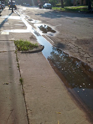 A reader wants to be sure Swamplot readers are alerted — as city inspectors, the HPD’s environmental division, and the property manager have already been, the reader says — to the “recurring” problem of raw sewage flowing out from the Takara-So Apartments at 1919 W. Main St. and into neighboring storm drains. The photo at left, taken on Monday, shows the sewage (“you can smell it”) along Colquitt St., pausing for a bit of sun on its way to lower-lying bayous and waterways. [Previously on Swamplot] Photo: Swamplot inbox

COMMENT OF THE DAY: POLLUTION CREDITORS  “It’s good to see that the Feds will help clean up the CES Environmental Services site. I’m of the opinion that bankruptcy law should be revised to require that environmental clean-up be paid for before creditors can be paid. It would help in cases like this, but it would also make lenders push dirty industries to clean up their act. Companies with bad environmental records would feel it in their ability to get credit.” [ZAW, commenting on Predicting Houston Real Estate Hotspots; Drinking Water from Lake Conroe] Illustration: Lulu

A spokesman says the Houston Police Department has “long been aware” of most of the 127 vehicles Texas Equusearch found submerged in Houston bayous back in 2011, when the nonprofit search-and-rescue organization used a sonar-equipped boat to hunt for the rented car of an elderly woman who had gone missing. But until Equusearch went public with the data this week, it appears no one from law enforcement had bothered to bring the rusting cars and trucks to the attention of environmental organizations, families of missing persons, wrecker drivers, classic-car collectors and restorers, bayou boaters, noodlers, or other groups that might have wanted to know.
No matter, now: Above, courtesy of Texas Equusearch and the Houston Chronicle, is an interactive map identifying the coordinates and descriptions of the vehicles — including at least one full big rig — that have been gently rusting at or near the bottom of Brays and Sims Bayous for at least 2 and a half years. The Chronicle data appears to exclude the half-dozen or so transportation options Equusearch searchers found beneath the waters of the relatively un-trafficked Buffalo Bayou. But you can spot some of them in the upper portion of this screen capture published with Joel Eisenbaum’s original report for KPRC of a similar map:
Submerged Bayou Secrets

WHERE THE POOP IS, IN AND AROUND LAKE HOUSTON  “While some Houston bayous, such as Buffalo and White Oak, have bacteria levels seven times higher than Lake Houston’s watershed, the waters flowing from the San Jacinto River are more vital, said Steve Hupp, Bayou Preservation Association spokesman. . . . Houston’s drinking water is pumped from an area of the lake not contaminated with bacteria.
Only the northwest corner of the lake is impaired, records show. This segment runs from where the river intersects Spring Creek, winds through Humble and past the Kingwood golf course, and ends at the West Lake Houston Parkway bridge.
The bacteria level found in the lake segment exceeds the state standard of 126 E. coli per 100 milliliters of water by 100 percent. Levels on both the river’s west or east forks are lower — exceeding the standard by 25 percent to 56 percent, depending on the segment. Yet a small tributary, Crystal Creek, which feeds into the west fork, has the highest count. It exceeds the state standard by 168 percent.
The communities along the San Jacinto watershed are experiencing a boom in development, especially around the river’s west fork in Montgomery County. Exxon Mobil already has a new 385-acre corporate campus that will be home to 10,000 workers under construction there, while the Boy Scouts recently sold their nearby 2,175-acre camp to a master-planned community developer for a reported $60 million.” [Houston Chronicle ($)] Photo of Lake Houston: Sara Robertson (license)
“While some Houston bayous, such as Buffalo and White Oak, have bacteria levels seven times higher than Lake Houston’s watershed, the waters flowing from the San Jacinto River are more vital, said Steve Hupp, Bayou Preservation Association spokesman. . . . Houston’s drinking water is pumped from an area of the lake not contaminated with bacteria.
Only the northwest corner of the lake is impaired, records show. This segment runs from where the river intersects Spring Creek, winds through Humble and past the Kingwood golf course, and ends at the West Lake Houston Parkway bridge.
The bacteria level found in the lake segment exceeds the state standard of 126 E. coli per 100 milliliters of water by 100 percent. Levels on both the river’s west or east forks are lower — exceeding the standard by 25 percent to 56 percent, depending on the segment. Yet a small tributary, Crystal Creek, which feeds into the west fork, has the highest count. It exceeds the state standard by 168 percent.
The communities along the San Jacinto watershed are experiencing a boom in development, especially around the river’s west fork in Montgomery County. Exxon Mobil already has a new 385-acre corporate campus that will be home to 10,000 workers under construction there, while the Boy Scouts recently sold their nearby 2,175-acre camp to a master-planned community developer for a reported $60 million.” [Houston Chronicle ($)] Photo of Lake Houston: Sara Robertson (license)
