COMMENT OF THE DAY: WHAT’S IN YOUR AIR  “There are three big air quality concerns for Houstonians: toxics, smog and particulates. Living in the East End puts you on the front line for toxic emissions. Toxics tend to be heavier than air and do not travel very far from where they are released. Milby Park had almost off the chart levels of Butadiene 1,3 back in mid 2000 due to problems at the Texas Petrochem plant next door. That problem was fixed and levels have come way down. But, if there is a release or a leak that is sending off toxics, the East End gets the best whiff. On days where there is little wind, the East End is also the spot most likely to get smog (NOx+SOx+sun=ozone). If there is good circulation in the atmosphere, Pearland to Sugar Land can see pretty bad smog, especially with the old coal plant in Sugar Land. But so can everywhere from Memorial Park up to the Woodlands. Houston’s smog has improved dramatically thanks to some good work by regulators and industry in identifying and going after the highly reactive stuff that really drives ozone production. But Houston is still in the top ten nationally when it comes to ozone. . . . Particulates are not as big a concern in Houston as we do not have much steel or other industries that are heavy on particulates, but we are still just over the new Federal standard of 12 parts per somethingerother. The particulates on the East End are generally higher than in other parts of town due to all the industry in the area. The air quality on the east side is definitely worse than on the west side. But ozone (smog) can visit just about anyone in the Houston area.” [Old School, commenting on Comment of the Day: The Limits of Eastward Development] Illustration: Lulu
Tag: Pollution
COMMENT OF THE DAY: THE LIMITS OF EASTWARD DEVELOPMENT 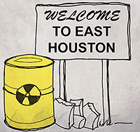 “With every mile moving east, you are getting nearer to Houston’s gigantic petrochemical industrial complex, along with its unpredictable environmental and public health issues, which begin just about a mile east of Eastwood (for example, look at the location of identified Superfund Sites in Harris County, . . . which gives a clear picture). This is the main reason why people in Houston, and those who can afford it, stay as much west as possible. . . . ” [Larry, commenting on Comment of the Day: What’s the Scoop on Eastwood?] Illustration: Lulu
W. A. PARISH PLANT ONE OF THE WORST POLLUTERS IN THE COUNTRY, FINDS REPORT 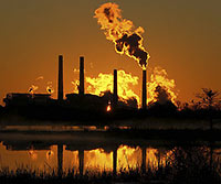 According to a new study published by Environment America, NRG Energy’s coal-firing W. A. Parish Electric Generating Plant, on Smithers Lake outside of Richmond, is really good at being dirty. Though the plant has been messing around with a way to clean itself up in the past year or so, the report, published today, still fingers it as the 5th dirtiest in the country when it comes to carbon emissions. And here, in order, are 1-4: “Georgia Power Co.’s Plant Scherer, Alabama Power Co.’s James H. Miller Jr. Plant, Luminant’s Martin Lake in Texas, [and] Ameren’s Labadie in Missouri.” [StateImpact; Environment America; previously on Swamplot] Photo: Flickr user Joe A.
COMMENT OF THE DAY: OH, AND WATCH OUT FOR THOSE AREAS NEAR THE SHIP CHANNEL TOO “If you are looking inside the loop at places like Eastwood or just outside the loop at places like Oak Ridge and Westbury, be careful that your house is at least 1000 feet from any highways. Living within 1000 feet of a major highway can expose your children to serious air quality issues in addition to what we already have to endure in Houston. Also, make sure that you get the house tested for lead paint and be ready to have some cash on hand to do some work to remediate any lead paint on the interior and any lead paint that is coming off on the exterior. I always thought that I was being overly cautious when I had my house remediated before moving in. But one day I had my then 4 month old baby on the changing table and watched as he scratched the paint on the wall with his finger and then put his finger in his mouth . . .” [Old School, commenting on Crazy for the Inner Loop]
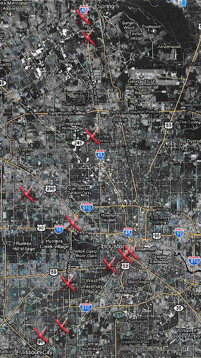
If you don’t live close to one of the locations marked with a red ‘X’ in the map above, you shouldn’t feel left out: There have been more than 3,900 documented instances of leaking underground fuel-storage tanks in Harris County, each of which poses “a risk to the nation and County’s drinking water,” according to filings in a new lawsuit. The locations on the map show only 13 of the 34 such leaky tanks belonging to telecom giant AT&T — they’re the ones the company admits have been polluting groundwater “with gasoline and hazardous substances . . . known to cause harm and adverse health effects.” The Harris County Attorney’s office filed suit against the telecom giant for neglecting its leaky-fuel-tank problem yesterday, citing a settlement in a similar case against the same company in California a few years back that netted a $25 million settlement.
- County files suit against AT&T for pollution from leaking underground storage tanks [Atascocita Observer]
NEW BRAUNFELS RESIDENTS APPROVE TUBING CAN BAN 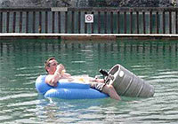 By a wide margin, New Braunfels residents voted to uphold an ordinance passed by city council over the summer that will prohibit Comal and Guadalupe River tubers from using disposable containers within the city limits. Supporters of the beer-can ban, which takes effect January 1, hope it’ll limit pollution from visitors; layers of tossed aluminum cans have been found lining riverbottoms after peak tubing season weekends. A group of local business owners has already filed suit to block the ban, claiming it violates state law. [San Antonio Express-News; previously on Swamplot] Photo: Lelombrik
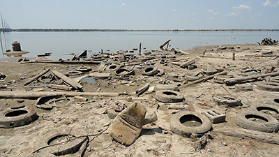
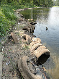 Low water levels have exposed more Lake Houston automotive bounty than just that mid-eighties Pontiac Fiero that was liberated from the city’s water supply over the summer: There’s lots more tires and car batteries to be found, too. Before the weekend’s rains threatened to cover it all up again, area residents pulled various debris and about about 100 tires found wedged in the mud from an old abandoned fish camp and marina at the end of Stillson Rd. on the city reservoir’s east side.
- Lake Houston residents clean shoreline covered in tires, debris [KHOU 11 News]
- Previously on Swamplot: What Now Passes for Waterfront Property on Lake Houston, Here’s What’s Been Clogging Up Your Water Supply, Houston
Photos: Roger Randall
PICKING UP CASH FOR THE CHEMICAL SPEW How did Harris County government swing half a million dollars in cash from Shell Chemical? The company is turning over that amount as part of a settlement covering 5 unreported chemical releases between April 2008 and March 2010 at the company’s Deer Park plant on Hwy. 225 just east of Beltway 8. According to Harris County’s lawyer on the case, Shell Chemical also made an “important concession,” which will likely result in more advance warning of similar future windfalls headed our way: Shell says it’ll now alert the county’s local pollution control office, and not just state officials, of “pollution events.†[Pasadena Citizen]
COMMENT OF THE DAY: JUST MESSIN’ WITH YA “More than once, a non-Texan has cited ‘don’t mess with Texas’ to me as an example of what they perceive as Texans’ aggressive, arrogant superiority complex. I love the sheepish look I get when I tell them, ahem, it’s an anti-littering campaign, and not something we made up to sound like bad-asses. . . .” [Katk, commenting on Don’t Mess with Don’t Mess with Texas]
THE POWER BALLS HAVE ARRIVED! Okay, fess up: Which one of you has been secretly transporting oil from the Deepwater Horizon gusher to our local beaches? The Coast Guard reported over the weekend that up to 5 gallons of dime- to ping-pong-ball-size tar balls collected from the surf along East Beach in Galveston and the Bolivar Peninsula’s Crystal Beach came from BP’s little offshore accident. But surely the little bugger-balls can’t have been trying to swim all the way back to headquarters? “[Coast Guard captain Marcus] Woodring said the condition of the tar balls didn’t look like they had drifted all the way from the Macondo well. They were ‘inconsistent with the weathering pattern that would be expected,’ he said. ‘To travel 400 miles is going to take a long time,’ during which the oil would be expected to break down. Officials were investigating whether the tar balls were from oil that clung to the hull of a ship passing through the BP oil slick or were from ballast water taken on by a ship in the oil slick zone and later dumped in Texas waters, Woodring said.” [Houston Chronicle]
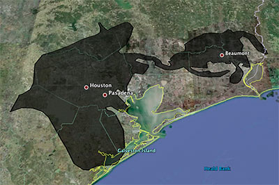
Playing around with a super-fun online tool that lets you superimpose the blobbish outline of the 2500-sq.-mile (and growing!) Gulf of Mexico oil slick from the Deepwater Horizon offshore-rig disaster onto various cities, Houstonist editor Marc Brubaker tries it on Houston — for size.
“It’s almost creepy how the slick follows I-10 out to Beaumont,” he comments. Of course, Brubaker should have nudged the oily blob a bit more to the east. Sure, he might have lost a few of those shiny exploration-company offices that have fled to the western stretches of Katy that way, but you’d be picking up lots of fun storage tanks and chug-chugging industrial plants at the northern reaches of Galveston Bay, and you’d get better coverage of Texas City, too.
Oh — but the outline is only up to date as of May 6th? Maybe we’ve got full coverage by now, then!
- Slicky Situation: The Deepwater Horizon Spill’s Actual Size [Houstonist]
- How big is the Deepwater Horizon oil spill? [Paul Rademacher]
Image: Houstonist
HOW TO PREPARE SAN JAC RIVER STEW What’s the local recipe for that San Jacinto River fishin’ favorite, toxic redfish? “The dioxins come from submerged waste pits north of the Interstate 10 bridge. McGinnes Industrial Maintenance Corp., which is no longer in business, owned and operated the pits in the 1960s, filling a 20-acre site on dry land with waste from a now-closed paper mill near the Washburn Tunnel. In the bleaching process, paper mills generated large amounts of dioxins, a family of compounds so toxic that scientists measure them in trillionths of a gram. The EPA says there is no safe level of exposure to the chemicals, which are known to cause cancer and disrupt immune and reproductive systems. The San Jacinto River began to run through the waste pits by the early 1970s because of subsidence — the sinking of soft soils as water is pumped from underground. With the McGinnes pits under water, the dioxins spread into the river and worked their way through the ecosystem, becoming more concentrated at each step in the food chain. For more than a decade, the Texas Department of Health has warned that fish and crab caught along this stretch of water, north of the Lynchburg Ferry, are tainted with cancer-causing dioxin, pesticides and PCBs. . . . In July, the EPA identified the International Paper Co. and McGinnes, which became part of Waste Management through a series of mergers and acquisitions, as the firms responsible for the dioxins problem. Under the Superfund law, the two companies will be required to evaluate and clean up the contamination. They paid about $65,000 for the fencing and roughly 50 warning signs in English, Spanish and Vietnamese, a McGinnes spokesman said.” [Houston Chronicle]
CEDAR BAYOU AIR UPSETS The Sierra Club and a Texas environmental group have filed suit against Chevron Phillips claiming a bonus supply of air pollutants and toxic chemicals has been escaping from the company’s Cedar Bayou chemical plant just north of I-10 in Baytown: “‘Like many companies in Texas, Chevron Phillips has repeatedly violated its own permit limits by emitting a wide range of harmful pollutants into the air from the Cedar Bayou plant,’ said Luke Metzger, Director of Environment Texas. ‘Because the state of Texas has failed to stop such violations at Cedar Bayou and elsewhere, citizen groups have had to step up and enforce the law themselves.’ The Clean Air Act contains a ‘citizen suit’ provision that allows private citizens affected by violations of the law to bring an enforcement suit in federal court if state and federal regulators do not. . . . Chevron Phillips’s permits contain both hourly and yearly limits on the amounts of pollutants it can emit into the atmosphere. The lawsuit alleges that equipment breakdowns, malfunctions, and other non-routine incidents at the Cedar Bayou complex have resulted in the release of more than a million pounds of pollutants into the surrounding air, frequently in violation of legal limits. A single such ‘upset’ or ’emission event’ can result in the release of tens of thousands of pounds of air pollutants in a matter of hours or even minutes.” [Environment Texas, via Houston Chronicle]
WHAT ABOUT THE FLARES? “An estimated 1,600 tons of smog-forming nitrogen oxides and volatile organic compounds are released in the Houston region each day. They mix with sunlight to form ozone, a colorless gas that can cause lung damage. Formaldehyde and other radical precursors matter because, without them, the volatile organic compounds emitted by cars, industry, paints and other consumer products would form much less ozone, [the Houston Advanced Research Center’s Jay] Olaguer said. Industrial flares burn off pressurized gases but also can shoot out massive amounts of noxious emissions. The Houston area has about 400 flare stacks, and they are among the largest and least- understood sources of pollution in the region, researchers said. A recent University of North Carolina study found that formaldehyde from flares may increase Houston’s ozone by as much as 30 parts per billion. In tandem with the pollution that blows into the region from elsewhere, that might be enough to keep Houston from meeting the new federal ozone limit of 75 parts per billion, scientists said. The state’s current plan for reducing Houston’s smog doesn’t consider formaldehyde and other precursors. ‘If there is a problem with flares, it upends the entire regulatory strategy,’ said Harvey Jeffries, an atmospheric chemist who conducted the UNC study.” [Houston Chronicle, via Off the Kuff]
From Downtown yesterday: Buffalo Bayou garbage flotilla!
- Crap on the Bayou [By the Bayou]

