CITY TRACKING DOWN THE LEAD IN CITY HALL’S DRINKING FOUNTAINS, EYEING OTHER DOWNTOWN FAUCETS  The city is planning to check in on the water at other buildings downtown, Scott Noll reports, in the wake of those lead tests KHOU did on drinking water from just City Hall and the City Hall Annex buildings last week. Those tests turned up lead levels so high above federal limits in at least 1 fountain that the city has shut them all off (and cleaned out the ice machines) while more extensive testing is done on the system. City spokesperson Janice Evans says city testing a few years ago didn’t show concern-worthy lead levels, but the fountains will stay off while the source of the current problem is traced out: “Is it the pipes? Is it the drinking fountains? Is it water coming into the building? It could be [any of the 3] options. There’s a lot of deferred maintenance in this building.”  [KHOU; previously on Swamplot] Photo of City Hall: City of Houston
Sign up for the Newsletter
Tag: Pollution

WHAT’S SO SPECIAL ABOUT THE PASADENA REFINERY THAT RELEASED 3 MORE TONS OF AIR POLLUTION ON THURSDAY?  “We worry about this plant more than we worry about the others,” Air Alliance Houston director Adrian Shelley tells Dylan Baddour after last week’s release of a 6,000-pound cocktail of toxic air contaminants from the Pasadena Refinery System complex, south of Buffalo Bayou just east of the Washburn Tunnel. The release occurred in the wake of a 7-hour power outage at the Petrobras-owned refinery (which played a role in the massive Brazilian corruption scandal that came to light last year); Baddour says this is the 8th contaminant release the company has reported so far this year (and the 65th since 2005). Shelley notes that the plant has a reputation for “large particulate matter (soot) release events that you really don’t see at other Houston refineries,” including the 2 tons of soot released on Thursday with sulfur dioxide gas and other contaminants; Shelley also notes that one of the plant’s key federal permits expired last year, resulting in a $7000 fine from the TCEQ. [Houston Chronicle; previously on Swamplot] Photo of Pasadena Refinery Systems, Inc. plant at 111 Red Bluff Rd.: Center for Land Use Interpretation (license)


The little and not-so-little red dots on the map above show off sites on the EPA’s list of plants and refineries required to have a Risk Management Plan due to their potential for accidental hazardous chemical releases — with the larger dots showing the places that have already had an accident (or, in some cases, as many as 43). Clicking each dot will tell you what the facility’s name is, as well as how much toxic or flammable material it stores on site (to the nearest thousand pounds or so).
The Union of Concerned Scientists and t.e.j.a.s. put together the interactive map as part of a report released late last week, which compares the EPA’s data on air quality and cancer rates in a few neighborhoods on the west side of town (specifically in Bellaire and in the West Oaks and Eldridge area, just inside Hwy.6 near the Barker reservoir) with the same data in a couple of east side spots (Galena Park and Manchester).
Sniffing It Out

WAIT, DID THE 2008 RECESSION UP THE CHANCES OF A FUTURE HOUSTON CHEMICAL CATASTROPHE?  Roy Scranton imagines “a wave of water sweeping toxic waste into playgrounds, shops and houses” in Magnolia Park in his op-ed this morning, written after touring the Ship Channel and speaking with the local A&M and Rice research teams pushing for variations on a series of region-scale coastal barriers to hunker down behind whenever the next gigantic hurricane hits the Houston region, in hopes of avoiding deadly flooding and catastrophic chemical spills. But the researchers tell Scranton that pushing for federal and state funding for a response is a slow endeavor; Jim Blackburn (a main player on the Rice team) tells Scranton that he’s “heard more than one person say our plan is to wait until the next hurricane comes, then depend on guilt money from Washington to fix the problem.” Scranton writes that the best chance for that guilt money so far might have been in 2008, when Hurricane Ike landed just 30 miles northeast of the zone that modelers say could have caused thousands of deaths and irreparable ecological devastation to the area, on September 13th — 2 days before the Lehman Brothers filed for bankruptcy, pulling global attention and national funds to other issues as markets began to crash. [NY Times; previously on Swamplot] Model maps of potential storm surge flooding along the ship channel, with chemical storage marked in red: Texas Tribune

YOU MIGHT WANT TO TAKE THAT DIOXIN OUT OF THE SAN JACINTO BEFORE A HURRICANE DOES IT FIRST  Yesterday marked the start of the 60-day public comment period on this week’s proposal to pull about 202,000 cubic yards of dioxin-laced muck out of the San Jacinto River near I-10. The Houston Chronicle editorial board was among the first to jump in (though not through official comment channels), highlighting the EPA’s conclusion that the waste, which has already been seasoning the seafood and (potentially) the river’s swimmers and nearby residents since the 1960s, could cause much larger problems if the wrong storm or hurricane hits the site; the board also calls out International Paper and Waste-Management-affiliated McGinnis Industrial Maintenance — companies potentially on the hook for the cleanup bill — for purportedly slowing down the cleanup process. [Houston Chronicle; previously on Swamplot] Map of higher-than-background dioxin levels near San Jacinto Waste Pits site at I-10: EPA


 Yesterday the EPA released their recommendations for what to do about the toxic muck in the San Jacinto Waste Pits, after more than a decade of local and federal agencies poking and fishing around in the area (on either side of the I-10 crossing of the river). So far the Superfund site has been temporarily dealt with by the 2011 placement of a pretty-much-just-a-tarp-with-rocks-over-it armored cap, which the EPA says has already been repaired at least 7 times; the document released yesterday notes, however, that disturbances at the site caused by weather and previous nearby sand mining operations “could cause a catastrophic release of the highly toxic waste materials from the impoundments, if they remain in place.”
The EPA wants to remove about 202,000 cubic yards of contaminated material (roughly enough to fill the floor of the Astrodome with a 13-foot-deep layer) but says it’ll have to be done carefully so as not to accidentally stir up the waste into the surrounding river while trying to get it out; the removal would also probably take place in stages to avoid potentially exposing too much of the waste at a time to storms or flooding. Here’s the EPA’s map of the 2 sites where the paper sludge was originally dumped in the 1960s — the (capped) northern area is outlined in blue and labeled Cap Site, while the southern site (outlined in yellow and labled Southern Impoundment) is covered in part by the Glendale Boatworks building, next to Southwest Shipyard:
Not Keeping a Lid on It

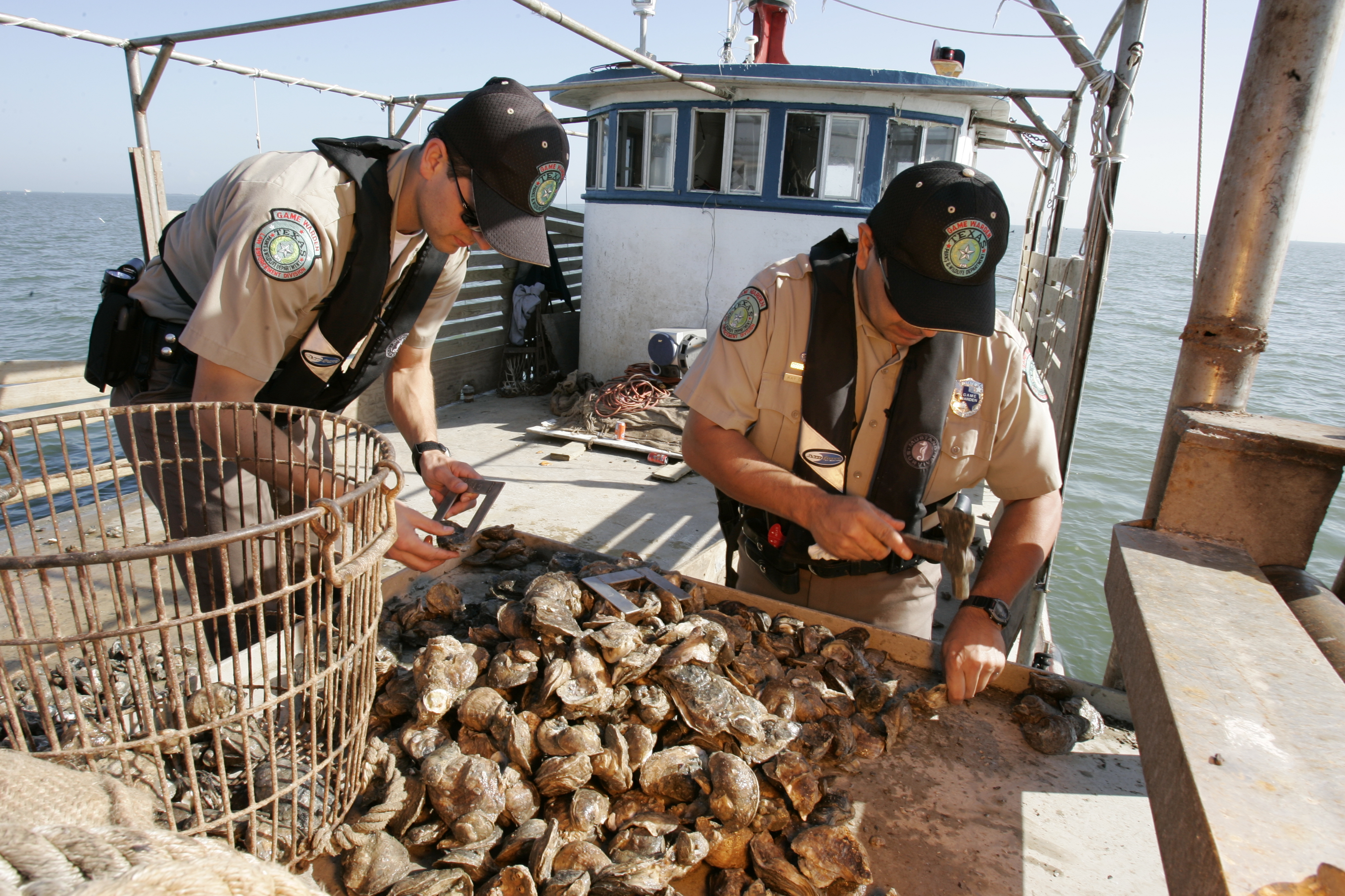
COMMENT OF THE DAY: THE PRICE OF SAVORING THAT MOUTHWATERING HOUSTON INDUSTRIAL FLAVOR  “I always found that Galveston Bay oysters had a slight metallic tinge to them (as compared to oysters from Matagorda or San Antonio Bays) — and actually, I quite like it. Perhaps it could be said that a true appreciation for Galveston Bay’s environs doesn’t come without some carcinogenicity. Oh well — so be it.” [The Niche, commenting on Oyster Tycoons Fight over Baybottom Territory as Reefs Recover from Flooding] Image of state game wardens examining oysters: TPWD


This month the Galveston Bay Foundation and Houston Advanced Research Center released their second annual report card on the health of Galveston Bay, boiling down a wide range of measurements into a series of letter grades. The report card, which looks at the bay itself along with the bayous that drain into it, aims to be easy to understand for folks with or without scientific training. Each of the 6 main categories of grade — including subjects like wildlife population trends, pollution sources, and human health hazards — is broken down with explanations of what specific measurements that rating is based on (and more details in the full report, for those who want them).
The agencies have also put together a Find Your Watershed tool, which lets you check in on how your own part of town is affecting the bay’s GPA. (That’s Buffalo Bayou watershed’s report shown above; the bayou did exceptionally well in dissolved oxygen and nitrogen content this term, but failed wetlands.) You can look up any address and see how the surrounding runoff area measures up in some of the report’s subject categories. (Note that the search tool’s map doesn’t use the same color-by-grade scheme that the rest of the report employs — you’ll have to click on each watershed to see the actual marks).
So how did the bay do this year?
Galveston Bay Schooling

FRIENDLY LOCAL BOT NOW CONTINUOUSLY TWEETING ABOUT HOUSTON’S ELEVATED AIR TOXIN LEVELS  Benzene levels have been relatively high near the TCEQ’s Channelview and Galena Park sensors today, according to the Twitter account of Kuukibot, the air-quality-obsessed automated program which Neethi Nayak, James Van Dyne, and some of the other civic-minded tech types at Sketch City launched last week with the Houston Air Alliance. (They were high yesterday, too — and the day before that, and the day before that.) Upon launch, Kuukibot’s feed immediately started filling up with short, sunny notes about levels of the carcinogen in those 2 neighborhoods; the lung-irritating 1,3 butadiene makes an occasional appearance in the feed as well, though few other places have shown up so far. The tweets, generated on the hour, don’t necessarily mean there’s a specific health hazard or legal violation occurring — just that the sum of the last 24 hours of TCEQ data for a particular sensor has crossed a certain threshold the team picked for each chemical as a reference point. The team is still working up public notes on the methodology, but according to Sketch City founder Jeff Reichman, the program wouldn’t be too hard to expand to most of the other chemicals (and other locations across the state) that the TCEQ monitors. [Previously on Swamplot] Capture of Kuukibot tweets: @kuukihouston

COMMENT OF THE DAY: WHAT’S REALLY STALLING HOUSTON’S DRIVE FOR SMOG REDUCTION  “ . . . The serious ways to improve air quality in Houston are 1) to pass California emission standards for all vehicles, and 2) to install traffic light road sensors at intersections. I can’t believe how long we sit at intersections with no one moving.” [KB, commenting on Building for Baby Boomers; Revamping the Briar Club in Upper Kirby] Illustration: Lulu

FIRST ZIKA BIRTH DEFECTS CONFIRMED IN HARRIS COUNTY AS CONGRESS GOES ON BREAK  On Friday Congress left for a 7-week recess without approving any funding to deal with the potential for the Zika virus to spread in the US; the break started just 2 days after Harris County Public Health confirmed the county’s first case of a baby born with Zika-related microcephaly. While no home-grown cases of the virus have yet been reported in Texas, Baylor’s Dr. Peter Hotez tells Maggie Fox that local spread “might already have started on the Gulf Coast and we would have missed it,” noting that federal funding would have given a boost to underprepared local agencies in mosquito-heavy Southern states. Hotez and other public health types say that the kinds of mosquitos that carry the virus (which are adapted to urban environments and are active during the day) are able to breed anywhere from a drip pan in a suburban refrigerator to the perennial piles of illegally dumped tires around Fifth Ward. Healthcare workers at Legacy Community Health Services also tell Fox that Houston is “a perfect place for Zika to take hold and reach a crisis point,” particularly since the 16-plus percent of Texans who are uninsured aren’t likely to seek treatment and get diagnosed.  [NBC] Photo of Legacy Community Health Services building at 1415 California St.: Candace Garcia


A Houston Chronicle attempt to get more info about the surprise chemical warehouse fire that turned Spring Branch Creek blood red earlier this year has been denied by the city, writes Matt Dempsey this week. The city has reportedly appealed to the state attorney general’s office to block the records request, as well as the paper’s broader request for “the name and address of every facility that files a hazardous material inventory form.”
The early May fire spread from a residence on Laverne St., igniting still-unquantified amounts of still-unnamed chemicals stored at the Custom Packaging & Filling warehouse behind it — a business that didn’t show up on the list of storage facilities the Chronicle was able to compile from local emergency planning groups, after the city and state blocked a previous request for similar info last year. The blaze left some firefighters with chemical burns and respiratory issues, and left stretches of nearby waterways decorated with festive biohazard signs and oil booms as the EPA did what they could about the mixture of pesticides and whatever else was killing the fish that drained from the site.
Knowing Your Neighbors

EXCESSIVE GALVESTON BEACH BACTERIA PROBABLY NOT LEG-THREATENING, JUST FECAL, SAY OFFICIALS  Scott Packard assures KHOU this week that the beach advisories put out by the Galveston County Health District lately aren’t related to flesh-eating strains of Vibrio bacteria — the agency has been fielding concerned phone calls in the wake of a Jacinto City man’s ongoing hospitalization and forced amputation due to a suspected Vibrio infection following a swim in Galveston with an open wound. But direct infection from seawater contact, while a perennial occurrence in Gulf Coast states, is nonetheless extraordinarily rare, Packard says. Rather, the beach advisories reflect above-standard measuremens of run-of-the-mill fecal bacteria: “Typically after periods of heavy rains [in] any recreational or coastal area, rain water will wash cattle waste, pet waste and some sewage overflows into the Gulf through rivers and streams, and that will make the levels spike for typically a day or so.” [KHOU; previously on Swamplot] Galveston Island sites with high bacteria levels: Texas General Land Office

Another effect of the Memorial Day weekend and early June floods: the EPA says it has had to pause some of its latest study efforts near the 1960s industrial waste pits in the San Jacinto river (shown at the top looking a bit more submerged than usual on May 31, facing north from the I-10 bridge). New rounds of sample-taking were triggered by the discovery in December that the Superfund site’s armored cap (which is made of special tarp material held down by a layer of rocks) had a 25-ft.-long hole where the rocks were missing. The EPA also notes that the damage was found within an area of the cap where no tarp was actually initially placed, in light of concerns that the rocks would slide off of it.Â
More Fun With Superfund

GROUP FORMS TO CLEAN UP THE UPPER SAN JACINTO BEFORE IT GETS AS BAD AS BRAYS, BUFFALO, SIMS BAYOUS  The West Fork of the San Jacinto River (implicated in much of the latest flooding between The Woodlands and Conroe) is in a bacterial “sweet spot”, environmental planner Justin Bower tells Matthew Tresaugue in the Houston Chronicle this week  — more contaminated than is acceptable, Bower says, “but not so much that we can’t do anything about it.” Tresaugue writes that E. coli levels have been trending upward since 2002, in some cases running as high as 10,000 colonies per 100 milliters of water (around 80 times higher than the 126-colony limit recommended by the state of Texas). The river’s water quality problems are multifaceted, but generally boil down to increased development in the watershed causing increased runoff that carries more junk — from human and animals waste to sediment from a nearby gravel mining operation — into the river and ultimately the Lake Houston reservoir (from which the city pulls drinking water). The newly formed West Fork Watershed Partnership has no definite plan yet (other than to work with area stakeholders to develop a plan). But Lisa Gonzalez (VP of the Houston Area Research Council) notes to Tresaugue that not doing anything could allow the West Fork’s water problems to get as bad as those of other major urban waterways in Houston. [Houston Chronicle; previously on Swamplot] Photo of West Fork of the San Jacinto: West Fork Watershed Partnership
