Articles by

Christine Gerbode

03/15/16 5:00pm

Demographic Map of Houston Census Blocks and Public Housing Projects, from Texas Housers

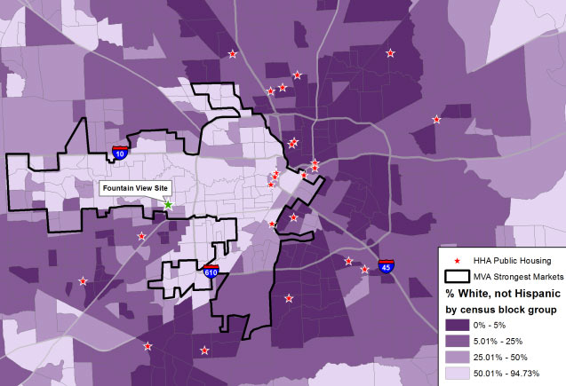
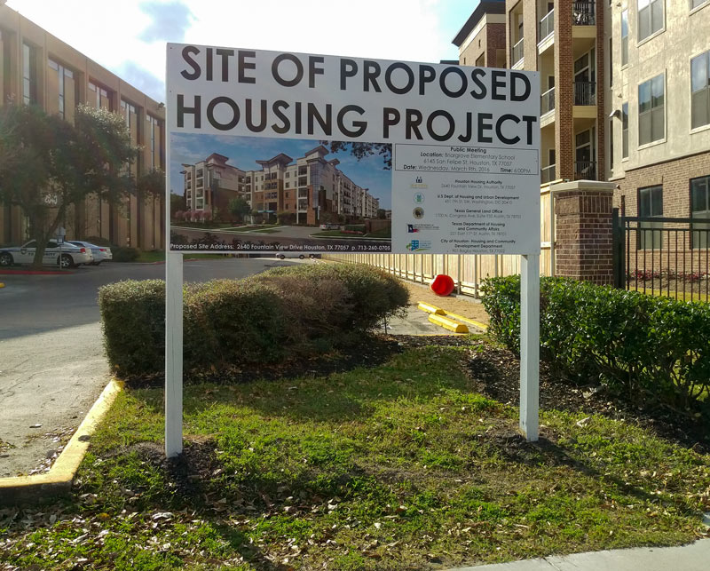
The pale arrow pointing from W. Beltway 8 to Downtown in the map of Houston above is made up of census blocks recorded as more than 50 percent white, according to a post by Will Livesley-O’Neill for Texas Housers yesterday. The Austin-based nonprofit, which researches low-income housing policy around the state, published yesterday’s article as a followup to some previous posts about the mixed-income housing complex that HHA is planning for the site of its own office building on Fountain View Dr. in Briargrove. The demographic breakdown on the other 3 shades shown on the map, from lightest to darkest: 50 to 25.01 percent white, 25 to 5.01 percent, and 5 to 0 percent.

The map also marks the locations of existing Houston Housing Authority public housing developments as red stars, mostly outside of or skirting the majority-white census blocks; the proposed Fountain View housing site is singled out, tagged, and marked with a green star. Meanwhile, the black outline looping mostly around the majority-white areas is lassoing the market areas deemed strongest by the Reinvestment Fund‘s Market Value Analysis for the city.

Map: Texas Housers

Visualizations
03/15/16 3:15pm

Construction at former Texas Cafeteria, 2400 N. Shepherd Dr., Houston Heights, Houston, 77008

A construction crew is currently at work around and on top of the bare former site of Texas Cafeteria, shielded from prying eyes on N. Shepherd Dr. by a small dirt pile. MFT Development (the group currently planning new and mixed uses for the site of the increasingly romantic former Heights Finance Station post office) is dressing up the space at the corner with 24th St. as another restaurant and maybe some retail, following the joint’s sale, shutdown, and stripping in early 2015. Behind the property to the right, the Fiesta Mart can be seen across 24th counting down to its March 27th closing, as the flags from Monterrey Tire Center peek over the former cafeteria’s roof.

Here’s a rendering of what the planned buildout could look like, plus or minus some tenant signage:

CONTINUE READING THIS STORY

Where the Fiesta’s Ending
03/15/16 11:15am

2200 Yale St., Heights, Houston, 77008

Alabama Furniture & Accessories’ 2-decade locale is getting cleared out for its planned redo, a neighbor notes. The building at 2200 Yale St. got a demo permit yesterday and started coming down later in the day. The site at the corner with 22nd St. is being cleared for another Braun Enterprises project: a third non-mobile Bernie’s Burger Bus location, as confirmed in October. The furniture store (named for its original 1992 location on Alabama St.) cleared out of its Yale home by the start of March, and has flown even further north to 4900 N. Shepherd Dr. between W. 43rd St. and Tidwell Rd.

Photo of demo at 2200 Yale St.: Mosaic Clinic team

Migrating North
03/15/16 10:15am

H-E-B mapped on Washington Ave. by Braun Enterprises

Later update, 2:30pm:  H-E-B’s Cyndy Garza-Roberts tells Swamplot that plans to place a store in the area are only in the discussion phase, and that no agreements have been reached — more here.

Update, 3/16: H-E-B has confirmed to the HBJ that the company has been in talks over a new store on the Archstone property.

A recent flier produced by Braun Enterprises in an effort to lease the former club space at 1815 Washington features a surprising extra: an overlay of the H-E-B logo planted squarely over a map of the not-so-square site of the Archstone Memorial Heights apartments on Washington Ave. between Studemont and Waugh. A 5-acre chunk at the southwest corner of the 1996 apartment complex was cleared out in 2008, then repopulated, then cleared out again in 2012 for redevelopment as the taller, denser Memorial Heights Villages complex (visible just to the right of the word “WAUGH” on the above aerial). CityCentre developer Midway bought the remaining 23.4 acres of apartments with the Lionstone Group at the end of 2014.

Also featured on the aerial: shuttered-over-the-weekend Hughes Hangar, which CultureMap’s Eric Sandler reports has closed along with Paris-minded parking lot companion The De Gaulle. Further east down the corridor is the space Braun is hawking: the former Pandora-turned-Throne nightclub space at 1815 Washington, marked with a star below, across the road from Bovine & Barley B&B Butchers:

CONTINUE READING THIS STORY

H-E-B Marks the Spot
03/14/16 5:00pm

Hughes Hangar, 2811 Washington Ave., Houston, 77007

Hughes Hangar, 2811 Washington Ave., Houston, 77007Hughes Hangar is finished with the spot at 2811 Washington Ave., behind Affection clothing boutique at the corner with Epstein Ct. The gastropub-nightclub announced on social media on Saturday that “everything is priced at $4.00” and that the business would close for good at the end of the night. The club posted earlier in the week about an electrical fire that knocked out audio and internet systems; posts to the venue’s Twitter and Facebook accounts on Thursday assured customers that the space would be open for the weekend, though the bar would be running cash only until credit card infrastructure was repaired.

CONTINUE READING THIS STORY

Weekend Getaway
03/14/16 1:45pm

COMMENT OF THE DAY: WHERE HOUSTON STAYED UNDERWATER AFTER THE MEMORIAL DAY FLOOD Flooded Home“Was there ever any kind of press writeup on why so many homes in Meyerland did not come back from this last flood? I’m saddened by all the vacant lots, and on some streets off Endicott, there are clusters of teardowns. Was insurance plus flood insurance essentially useless for all of those homeowners? Or was it the new city building requirements? Genuine questions, because I’ve been in the area 30 years and this [flooding] seems to have been so much more devastating than Allison (and Ike).” [Heather, commenting on Daily Demolition Report: As Is, Where Is] Illustration: Lulu

03/14/16 11:30am

Tree Removal by Apartments at 1850 Colquitt St., Montlew Place, Houston, 77098

A post-departure portrait of greenery along the Hazard St. side of the apartments at 1850 Colquitt St. comes with questions from a reader: what’s planned for the 16-unit complex across from the directionally-rebranded Takara-So complex? The shot above shows the leftover bits of 3 trees cut down at the site at the end of February; the 1948 complex changed hands most recently late last fall. Earlier last year, the building was a good deal greener all around — here’s a shot from its listing days from the corner of Colquitt and Hazard, showing the complex covered in ivy:

CONTINUE READING THIS STORY

Stumped on Hazard
03/14/16 10:00am

Jefferson Davis Site Plan 2014, Quitman at Tackaberry St., Northside, Houston, 77009

Cast in projector blue above: a snapshot of renderings for the remodel of Jefferson Davis High School, which is planning to expand. The Northside school, one of 8 in HISD changing names to drop references to Confederate figures, is getting some shiny new teaching facilities, including upgraded spaces for its culinary arts and management students (as shown in the projection above). The campus on Quitman St. is also staking out new parking lot territory across Tackaberry St.

Hungry for the details? HISD is hosting a community meeting on April 7th at the school to talk design plans. Until then, here’s a preview of the planned new exterior for the performing arts space:

CONTINUE READING THIS STORY

Northside Remake
03/11/16 4:00pm

Obama Mural, Travis St. and West Alabama, Midtown, Houston

The president has just wrapped up his keynote speech at hippie-turned-techie-festival SXSW in Austin — but he’s been sighted all over the place today, including at the oft-redecorated corner of Alabama and Travis streets across the street from the Breakfast Klub. The newest mural was finished up last week in the recently whitewashed spot that has hosted various incarnations of Obama’s likeness over the last few years (and been vandalized several times).

Obama was also photographed earlier this afternoon at a Torchy’s Tacos in South Austin, where he reportedly ordered a Democrat, a Republican, and an Independent before heading back to the motorcade:

CONTINUE READING THIS STORY

On the Trail
03/11/16 2:45pm

WEIGHING THE OPTIONS ON KEEPING HOUSTON RELATIVELY DEVASTATING-STORM-SURGE-FREE GCCPRD Coastal Spine and Alternative Map
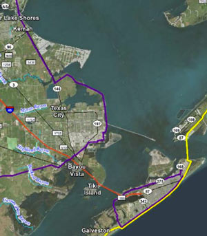
A quick key to this map of Galveston Island and southwest Galveston Bay: (1) The yellow line shows the path of the ‘coastal spine’, a 60-mile seawall that would run along Galveston Island to Bolivar peninsula, with an enormous set of floodgates between the landmasses. The spine is a much-argued-over proposal to combat freakout-worthy flooding from future hurricane storm surges that could threaten the nation’s tennis ball supply. (2) The purple line shows an alternate plan proposed by the Gulf Coast Community Protection & Recovery District: put a ring around the city of Galveston (not the island itself), and place or expand levees along the mainland. Kiah Collier writes in the Texas Tribune yesterday that the GCCPRD’s recently released report makes a regional consensus on what to build way less likely any time soon: The study group says that the levee plan “would provide a nearly equivalent level of protection while costing several billion dollars less [than the coastal spine]. The catch: several Houston-area communities on the west side of Galveston Bay, including Kemah, La Porte, Seabrook, Morgan’s Point and San Leon, would be left outside the dike.” Public meetings with the GCCPRD are planned for the end of the month in Galveston, League City, Lake Jackson, and Orange. [Texas Tribune; previously on Swamplot] Map of coastal protection alternatives: Gulf Coast Community Protection & Recovery District report

03/11/16 1:00pm

March 11th Mural at former Heights Finance Station Post Office, 1050 Yale St., Houston Heights

Update, 5 pm: Work on the wall is finished; this article has been updated with additional photos.

A reader catches more than a dozen folks in the act of dolling up the former post office at 11th St. with some giant hearts and numbers this morning. The building, which was recently given a Valentine’s-themed makeover on the opposite side by some likely-taller members of the Houston mural scene, has been getting romantic attention while waiting for MFT Development to go forward with plans to demolish the structure to build a lowrise retail and office complex.

In the interrim, MFT says they’ve set the art students of Hogg Middle School on the Heights Blvd. side of the building. Here’s another shot of the action, looking closer to 11th:

CONTINUE READING THIS STORY

Love All Around
03/11/16 11:00am

Site of Proposed Housing Development at 2640 Fountainview Dr., Briargrove, Houston, 77057

Site of Proposed Housing Development at 2640 Fountainview Dr., Briargrove, Houston, 77057Here are some shots from the scene of the Houston Housing Authority’s office park on Fountain View Dr. north of Westheimer Rd., which the organization is planning to partially demolish and replace with a 233-unit mixed-income apartment complex. The sign shown here went up last month to advertise this week’s public meeting on the proposed construction, which drew standing-room-only crowds to the auditorium of Briargrove Elementary. A group of neighborhood residents is campaigning to stop the project; listed grievances include a lack of transparency surrounding the project, and asserting that school overcrowding wasn’t considered when HHA picked the spot.

The property, just north of the vacant H-E-B northwest of the corner with Westheimer, currently holds 2 office buildings sporting gently-bent-rectangular floorplans (that’s 2650 in the foreground, in the photo above, with 2640 behind it). An aerial rendering released by HHA shows 2640 swapped out for the apartment building, with the southern office building still in place below it:

CONTINUE READING THIS STORY

Trading Spaces