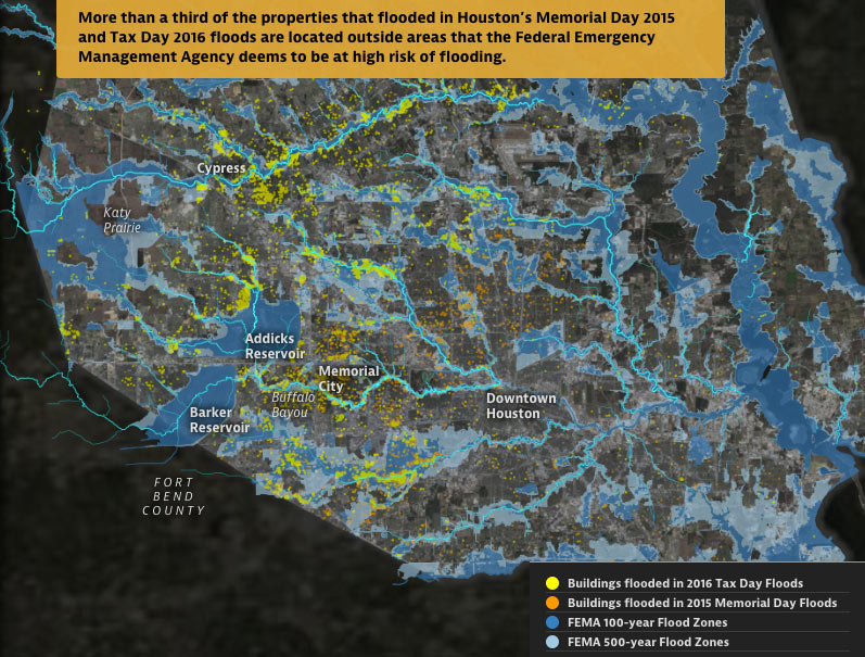
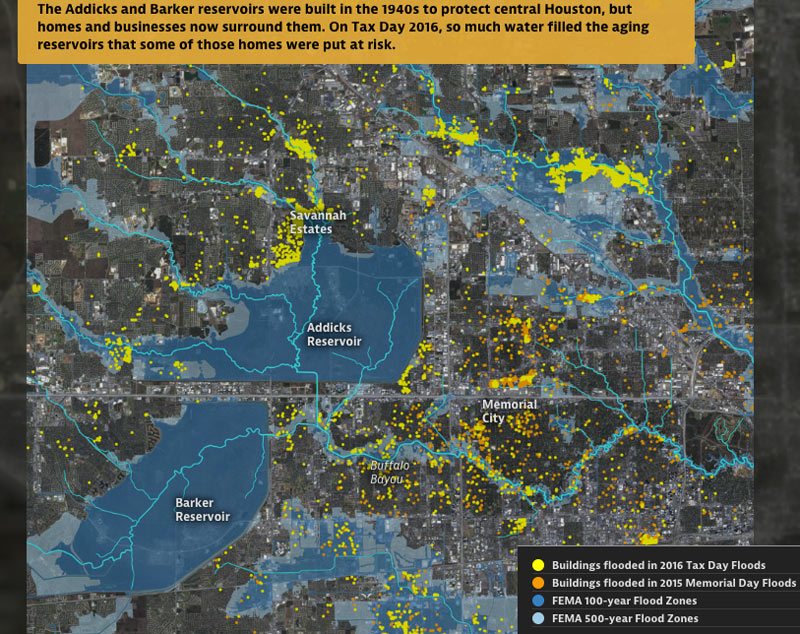
from Boomtown, Floodtown (Texas Tribune and ProPublica)

From some of the same folks who brought you those fun-with-worst-case-scenarios hurricane flood maps earlier this year —  Neena Satija and Kiah Collier of the Texas Tribune, and Al Shaw of ProPublica — comes a fresh set of animated maps of a few of Harris County’s most flooded and floodable places, along with a bit of investigation into how they got that way (and whether that might change any time soon). The new illustrated presentation shows off the spread of properties that took a dip during some of Harris County’s last few citywide submersion events (flooded properties from Tax Day 2016 are shown in yellow above, along with the Memorial Day 2015 flooded properties in orange).

Texas A&M Galveston researcher Sam Brody tells the authors that “more people die here than anywhere else from floods. More property per capita is lost here. And the problem’s getting worse.” In sorting through some of the whos, whats, and hows of Harris County’s flood infrastructure and chronically soggy residents, the article juxtaposes the recent flood damage data with the likes of FEMA-mapped 100- and 500-year flood zones (shown above), a visual tally of the land area developed last decade, and a view of what’s left of Houston’s coastal prairie (as of 2010):

CONTINUE READING THIS STORY

by Christine Gerbode
12/07/16 2:30pm

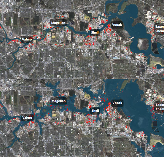
WAIT, DID THE 2008 RECESSION UP THE CHANCES OF A FUTURE HOUSTON CHEMICAL CATASTROPHE? Predicted Before and After Flood Map, 500 Year Flood EventRoy Scranton imagines “a wave of water sweeping toxic waste into playgrounds, shops and houses” in Magnolia Park in his op-ed this morning, written after touring the Ship Channel and speaking with the local A&M and Rice research teams pushing for variations on a series of region-scale coastal barriers to hunker down behind whenever the next gigantic hurricane hits the Houston region, in hopes of avoiding deadly flooding and catastrophic chemical spills. But the researchers tell Scranton that pushing for federal and state funding for a response is a slow endeavor; Jim Blackburn (a main player on the Rice team) tells Scranton that he’s “heard more than one person say our plan is to wait until the next hurricane comes, then depend on guilt money from Washington to fix the problem.” Scranton writes that the best chance for that guilt money so far might have been in 2008, when Hurricane Ike landed just 30 miles northeast of the zone that modelers say could have caused thousands of deaths and irreparable ecological devastation to the area, on September 13th — 2 days before the Lehman Brothers filed for bankruptcy, pulling global attention and national funds to other issues as markets began to crash. [NY Times; previously on Swamplot] Model maps of potential storm surge flooding along the ship channel, with chemical storage marked in red: Texas Tribune
by Christine Gerbode
10/07/16 10:30am

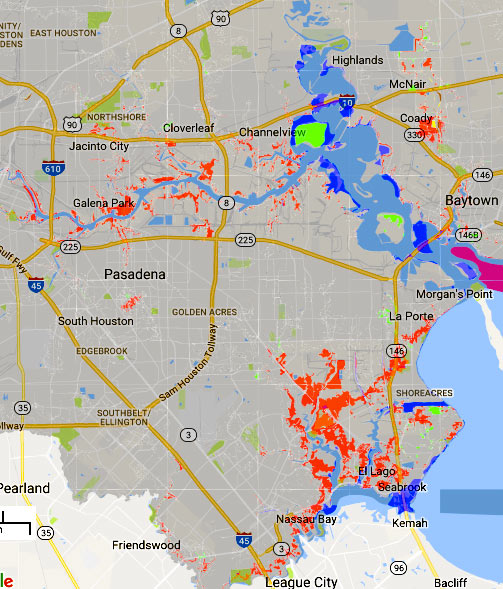
Jan 2017 FEMA Special Flood Hazard Zone classification changes

The areas in red above mark some of the new additions to the legally-gotta-buy-flood-insurance zones on FEMA’s recently revised flood maps. The agency’s interactive online viewer lets you mix-and-match a few data sets for Harris County (as well as Galveston, Fort Bend, and Wharton), compare the old mapped flood zone boundaries to proposed new ones, or look only at what would change — a FEMA spokesperson told Houston Public Media that about 8,000 properties have been added to the list in Harris County, while only about 400 were dropped.

Those acid-green highlights are areas that have been removed from the special flood hazard zone by the updated map (while blue shows areas that have just changed floodplain classification some other way. Bits of brown and yellow in other areas of the map show places added or removed (respectively) from the floodway. The updates above to the mandatory flood insurance zone (legally called the Special Flood Hazard Area) are set to go into effect in January, as shown above. Buffalo Bayou and its tributaries are pretty marked up:

CONTINUE READING THIS STORY

by Christine Gerbode
10/04/16 5:00pm

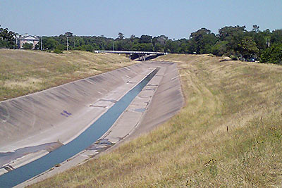
MIGHT WHITE OAK BAYOU DITCH ITS CONCRETE? white-oak-bayouThe Harris County Flood Control District is looking at removing the concrete lining from sections of the White Oak Bayou channel, writes Mihir Zaveri. The agency is conducting a study on redeveloping parts of the waterway along with the Memorial-Heights Redevelopment Authority (a.k.a. TIRZ 5); any future projects to come from the study would be within the TIRZ 5 boundaries, along sections of White Oak between roughly N. 610 and Houston St. Zaveri writes that the push “in part reflects the idea that waterways where flooding must be controlled don’t have to be eyesores, and in fact can become more natural settings for residents to bike, walk and gather. It follows decades-old conversations about how to shape waterways in a flood-prone region like Houston, where the rapidly growing population has increasingly come to demand improvements in quality of life.” With respect to balancing aesthetics against effective flood control practices, TIRZ 5 chairwoman Ann Lents tells Zaveri that “pretty is never going to trump functional . . . But because of new techniques, if we can find a way to do both better, I think that will be a great thing.” [Houston Chronicle] Photo of White Oak Bayou: Swamplot inbox
by Christine Gerbode
07/13/16 5:15pm

WHY THAT ONE HOME IN THE BRAZOS FLOOD ZONE DIDN’T FLOOD Meanwhile, in Abbeville: The giant water-filled tubes of California-based AquaDam are getting some love from a homeowner with property near last week’s mandatory evacuation zone south of Houston. Upon hearing the Brazos River Authority’s flood predictions, Randy Wagner says he drove to the company’s Louisiana headquarters to pick up the 400-ft.-long structure, and deployed it around his house in Rosharon: “I was the crazy guy,” Wagner told KHOU. “Everybody was kinda going by, laughing at me. But today they are really impressed . . . ” The dams are marketed most heavily for construction purposes, but also as a replacement for sandbag barricades in flood situations. Notable past deployments include the Ft. Calhoun Nuclear Generating Station in Blair, Nebraska where the dams successfully kept out 2 ft. of water from the nuclear plant during flooding in 2011 — until the AquaDam was accidentally popped. [KHOU, New York Times]

by Christine Gerbode
06/10/16 4:45pm

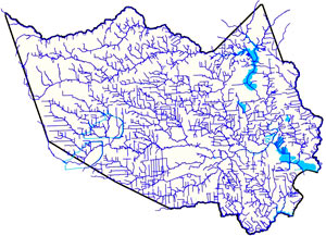
THE ESTIMATED PRICETAG ON A STOP TO HOUSTON FLOODING Harris County Flood Control District channel mapAmid the latest round of area flooding last week, Dylan Baddour traces the roots of Houston’s massive publicly funded drainage projects, which have brought the total length of Harris County waterways up to 2,500 miles (many of those channels widened, lined with concrete, or dug from scratch). Baddour also talks with current county flood control district director Mike Talbott about what it would take to expand and refine the city’s outdated flood infrastructure (which is often locked into place by close surrounding development) up to modern expectations — namely, that the flow of water over land that would otherwise be totally submerged should be totally controlled. Baddour writes that Talbot “has a simple solution: allocate $26 billion, more than a fifth of the state’s 2015 budget, mostly to buy property adjacent to the waterways, bulldoze and expand the canals.” Rice University ecologist Ron Sass tells Baddour he’s surprised the city hasn’t been tearing down old houses to build new bayou channels: “We build freeways. I would think that a bayou would be as important to our infrastructure as a freeway.” [Houston Chronicle] Map of Harris County waterways: Harris County Flood Control District  

by Christine Gerbode
06/07/16 10:15am

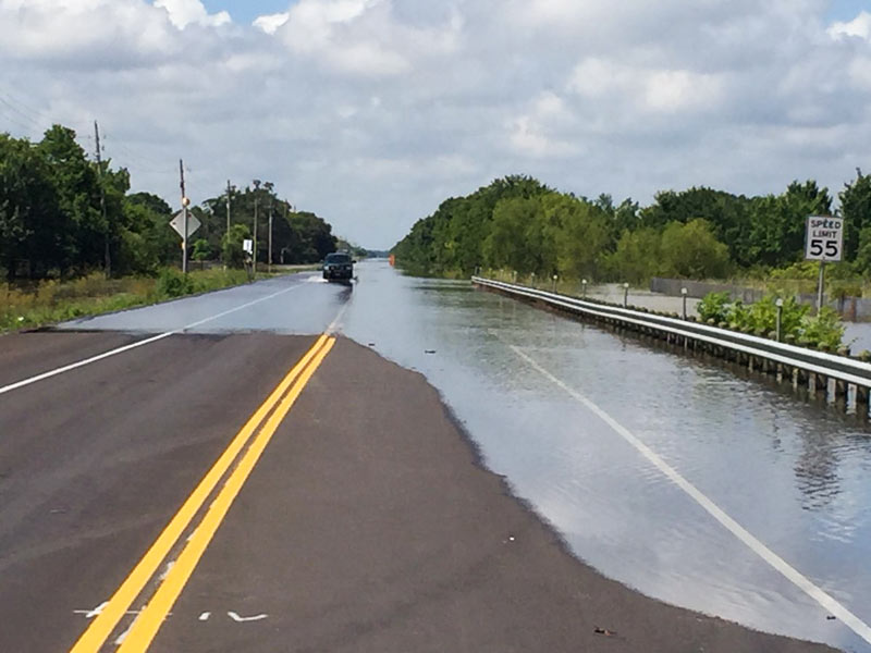
Flooding along FM 521, Brazoria County, TX 77515

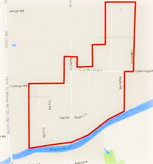
Fort Bend County Boil Notice Area, June 6Residents of the Rio Brazos area near Cumings Rd. north of Rosharon are being advised as of this afternoon to boil their tap water until further notice, while the Fort Bend County Fresh Water Supply District 2 sorts out possible problems stemming from a flood-related loss of water pressure in the network. (The map included here has been added to the Fort Bend County emergency office’s Facebook page following a brief online outpouring of confusion as to what neighborhoods the warning was actually targeting.)

Meanwhile, TXDOT is still listing dozens of miles of roadways as covered by to high water as of this morning, with more closures expected as Brazos floodwaters drain southwest toward Angleton and Freeport. Here’s Brazoria County’s latest worst case scenario potential floodmap, with the county’s mandatory evacuation zones now stretching across more than 15 miles from roughly Brazos Bend State Park to the outskirts of Angleton:

CONTINUE READING THIS STORY

by Christine Gerbode
06/06/16 5:30pm

COMMENT OF THE DAY: WHY FLOOD CONTROL ENTHUSIASTS KEEP EYEING PREVIOUSLY PAVED LOTS Flooded Home“This is a standard practice: to elevate [existing] commercial properties so they will drain off the property. It is very easy to do. The concern is that the city of Houston does not require new properties on old lots to detain water on the lot.  . . .  Elevated commercial properties that do not mitigate acre-foot-for-acre-foot will lead to water running off and flooding adjacent properties. It is a simple concept, but developer propaganda is strong. The most common myth promulgated by the developers is that if something was already concrete then a new property need not mitigate run-off. The fact is, any time a new development is built that does not mitigate run-off, it will force water onto its neighbor. [Flooding, commenting on Former Fiesta Site Preps for Teardown as Heights Dry Zone Petitioners Circle] Illustration: Lulu
by Christine Gerbode
06/06/16 2:00pm

may-31-flooding-FM-723-rosenberg-2

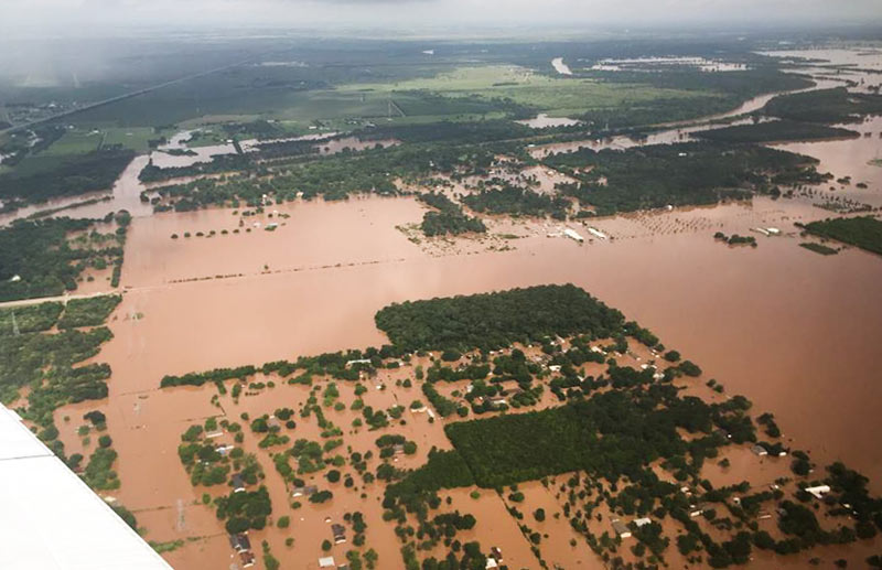
TxDOT has been doing some circling around over the thoroughly soaked Brazos River valley this week grabbing a few snapshots, including some taken yesterday morning as 31 East and Central Texas counties picked up flood-related disaster declarations from the governor’s office. Running north-to-south (right-to-left) under the murky waters shown above is FM 723 in Rosenberg, TX; you can spot the bridge rising up to cross the river’s normal channel on the left side of the photo, while SH 36 stretches away to the northwest.

Flash- and non-flash flood warnings are in effect around the region through at least Friday night, depending on how intense the rest of this week’s predicted downpours turn out to be. Meanwhile, the already-feet-past-the-previous-record flood gauge at nearby Richmond, TX, is still creeping upward this morning toward 55 ft.:

CONTINUE READING THIS STORY

by Christine Gerbode
06/02/16 10:30am

The footage above captures Ed Nelson’s high-water trek last Monday through an overflowing detention basin at the corner of Bob White Dr. and Reamer St. just north of Brays Bayou. Nelson narrates his soggy expedition through the basin (which sits at the south end of the Robindell and Braes Timbers neighborhoods, between Hillcroft Ave. and Fondren Rd.) as he attempts to document different flows of water into and out of the pond; he ultimately claims that water is flowing into the detention pond from Brays, and moving from there into the floodway easement running behind nearby houses on Reamer.

Nelson and other neighbors claim that the surrounding area did not flood prior to the detention basin’s completion in 2008, and that the detention pond was intended to collect water from the surrounding neighborhood and prevent it from flowing too quickly into Brays bayou  — whereas during the Tax Day and Memorial Day floods, the basin purportedly collected water from the bayou and channeled it into the neighborhood, causing houses to flood that neighbors believe might not have otherwise.

CONTINUE READING THIS STORY

by Christine Gerbode
04/26/16 4:30pm

COMMENT OF THE DAY: A HISTORICAL METHOD OF EXPANDING HOUSTON’S FLOODPLAINS Illustration of Flooding House“Another recent policy development is that subsidence is now taken very seriously (with massive infrastructure being built to put utility districts onto surface water from Lake Houston and the Trinity River). But it was a very, very big problem up until around 1990. So you had all this sprawling development inside of Beltway 8, and off of 1960, and out near West Oaks, and there wasn’t adequate on-site or off-site stormwater retention infrastructure that had been built — and that same development thereafter was sinking at a steady rate, so that any flood control infrastructure was becoming increasingly obsolescent for reasons other than simply rainfall rates and runoff.” [The Niche, commenting on Comment of the Day: Who Foots the Bill for Houston Floods] Illustration: Lulu
by Christine Gerbode
04/25/16 2:45pm

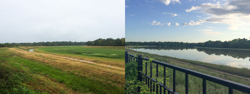
A water-watching reader sends some south-facing photos from yesterday evening (right) and last October, comparing views over the fenceline of the 400-ft.-wide diversion channel at the northern edge of the Addicks reservoir. The channel picks up most of the flow from Langham and Horsepen creeks where they join up as they flow south into Addicks. The 400-ft.-wide floodway was dug in the 1980s; the flow usually lurks down in the narrow channel seen in the shot on the left.

The scene above is less than a mile east of Bear Creek Village, where water is now moseying into neighborhoods from the western edge of the reservoir (and washing some wildife and livestock around). The Army Corps of Engineers has been releasing water from both Addicks and Barker dams to minimize the pooling (and relieve stress on the dam structures themselves) — but those releases have to be done slowly enough to avoid causing additional flooding downstream along Buffalo Bayou. Meanwhile, water is still flowing into the reservoirs from western watersheds; the measured levels behind the 2 dams topped all previous water level records and normally allowed pooling limits in the reservoir by Tuesday, and has been rising since. Here’s a shot of water gushing out through some of the gates of the Barker dam this afternoon:

CONTINUE READING THIS STORY

by Christine Gerbode
04/22/16 3:30pm

A few folks at the Halstead apartments surveyed the scene along Brays Bayou late yesterday morning, catching sight of all kinds of action in the water. The video above captures the part of the lonely journey of an unmoored porta-potty floating away from the site of the under-construction Starbucks on the former gas station corner next door; the trip was also also tracked from further upstairs in the complex, where another photographer was documenting the flood:

CONTINUE READING THIS STORY

by Christine Gerbode
04/19/16 1:30pm

A scattering of drones took to the air across Houston yesterday as the rain slowed to do some sight-seeing around the brand new 9-county disaster zone declared by governor Abbott in the afternoon. Filling up during floods is standard operating procedure for Buffalo Bayou Park, as demonstrated prior to the park’s first planned official opening last spring. That’s not part of the sanctioned protocol for all of Houston’s bayou corridors, but it’s hard to argue about it in the moment —above is the overhead view of Brays Bayou venturing out into broader Meyerland.

More footage comes from northwest Houston, circling around White Oak Bayou at N. Houston Rosslyn Rd. in Inwood Forest —  west and downstream of some the areas that got the most rainfall:

CONTINUE READING THIS STORY

by Christine Gerbode
04/19/16 11:00am

Harris County FWS channel map, April 18, 2016

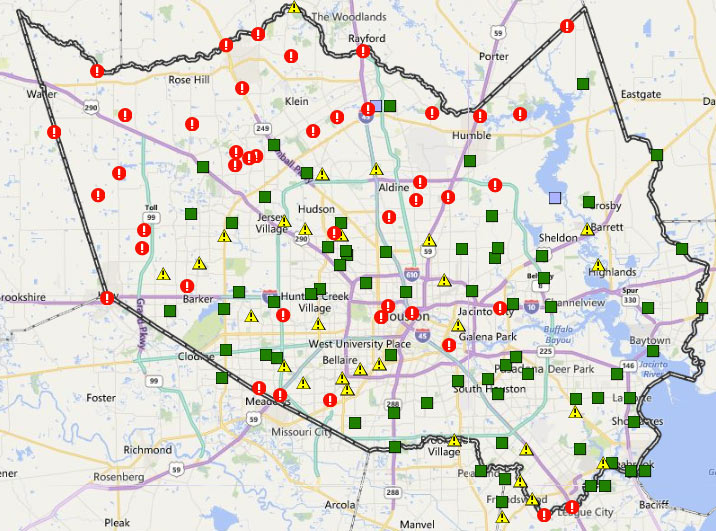
The many exclamation points scattered across the map of Harris County above mark spots where stream channels are currently overtopping their banks (in red!) or potentially thinking about it (in yellow!). The capture comes from the Harris County flood warning system interactive map, which automatically updates data from its county-wide network of rain and flood gauges every 5 minutes. Most of the current overtopped locations are concentrated toward the northwest areas of the county, parts of which got more than 17 inches of rain since Sunday morning. The green shapes mark channel gauges that aren’t currently at spillover stage or close to it (whether or not any spillover occurred earlier today).

The county’s online map also shows cumulative rainfall across the area — here’s what the totals look like across town for the last 24 hours:

CONTINUE READING THIS STORY

by Christine Gerbode
04/18/16 2:45pm