MLS IN HOUSTON: MANDATORY SECRET SALES PRICE DISCLOSURE Responding to reports that home sales prices have been systematically omitted from MLS records in Dallas, a few Houston Realtors tell the Chronicle‘s Nancy Sarnoff that sort of thing can’t happen here: “. . . after a house sells, the price is supposed to be recorded on the Multiple Listing Service by the real estate broker who sold it — a practice that’s hard to get around, in Houston, at least. That’s because agents are bound by MLS rules to report the price or face a $250 fine and possible suspension. ‘If the seller doesn’t want their sales price reported, then they can’t list it in the MLS,’ said Shawn Dauphine of the Houston Association of Realtors, which runs the MLS — a database of listings of homes on the market and those that have sold. Members of the association have access to price data, but the public does not. . . . Over the last 12 months, just three agents in this area were fined for not reporting sale price. The problem is more severe in Dallas because the group that runs the MLS there has an exception in its rules that allows the seller’s agent to report the last known list price in lieu of the sales price, Dauphine said.” [Houston Chronicle; previously on Swamplot]
Online Resources
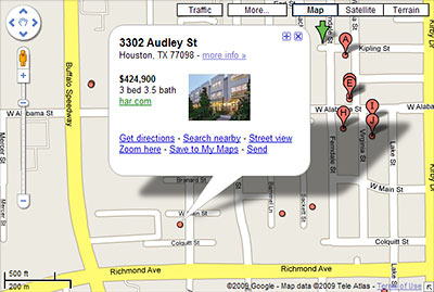
A few new features now make it much easier to search for real estate listings directly from Google Maps. Although you can’t limit searches as neatly as you can with the map functions of some other real-estate sites — and the listings don’t come straight from MLS — Google doesn’t make you register for anything, and this map search isn’t so likely to crash your browser. The listings are integrated into the standard Google Maps interface, and links to the listings themselves are easily accessible.
You can start searching Houston listings simply by searching for “Houston real estate” on Google Maps. Click on the first result (“Real estate on Google Maps”) to see more listings, which appear as tiny dots on the map. Click on any of the dots to find more information about a particular property.
What’s most interesting about the new real estate features is how neatly they allow househunting to fit in with more everyday map activities. Real-estate obsessives, take note: Searching for listings no longer has to be such a deliberate act. Looking up directions to a friend’s house? You can scour listings along the route with just a few extra clicks. Wondering about the real estate action near one of the demos in Swamplot’s Daily Demolition Report? You no longer have to navigate to a separate site to do that.
Here’s how to try it:
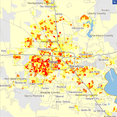
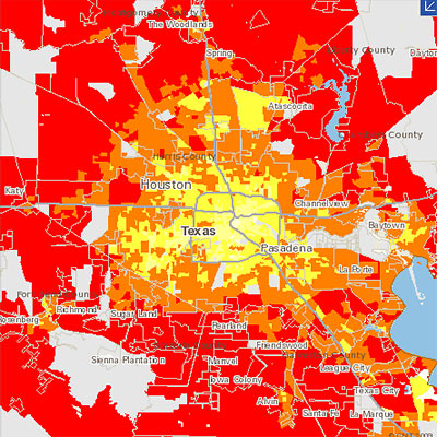
The Center for Neighborhood Technology has updated its interactive region-comparison website to show data comparing carbon dioxide emissions around the Houston region. The Housing + Transportation Affordability Index now allows you to compare CO2 emissions — from “household vehicle travel” only — on side-by-side zoomable maps.
The 2 new data sets available show CO2 emissions per acre (at the top above), and CO2 emissions per household (directly below that) from household auto use. The Houston-Galveston-Brazoria region is one of 55 U.S. metropolitan areas mapped on the website. The center’s point?
When measured on a per household basis, it found that the transportation-related emissions of people living in cities and compact neighborhoods can be nearly 70% less than those living in suburbs.
The center figures that transportation accounts for 28 percent of all greenhouse gas emissions in the U.S.
Other H+T map tools focus on how affordable different locations are to live in — when you take transportation costs into account:

Five Houston designers are gathering on the ground floor of Hometta, a new web-based business that aims to promote and sell plans for small Modern homes. Architect James Evans of Collaborative Design Works, Rice architecture professor Dawn Finley of Interloop Architecture, Brett Zamore of Brett Zamore Design, and Blair Satterfield of HouMinn Practice are scheming with architect Andrew McFarland to build up a company store of designs measuring less than 2,500 sq. ft. Hometta’s founder is developer Mark Johnson of Area 16 Homes.
The company plans to have designs from 25 different studios ready for the launch of its web catalog next month, available under a tiered subscription system. Access to design renderings will be available for a small fee; for a larger fee, customers will be allowed to look through plans on the site and give access to contractors for bidding.
Once the customer finds a builder and receives a bid they are happy with, they may then buy the plans, which range from $1195 for a studio-sized house to $3195 for a 3-bedroom. Our Builder Search feature will help match homebuyers with a qualified builder in their area.
After that, you’re on your own:
Okay, that guy with the lawnmower is just a little creepy, no?
Committed real-estate snoops, come out from behind your laptop screens. With Zillow’s new iPhone app, you can just pull out your device and lurk . . . in person! And . . . uh, it follows you!
- Zillow Launches iPhone Application [Geek Estate]
- Zillow Takes Zestimates to the Streets [Future of Real Estate Marketing]
- Zillow iPhone App [YouTube]
 Here’s a brand-new home-search tool that will likely change the way you hunt for residential properties in Houston. And you can find it on the website of . . . a real estate agent working out of this Pearland strip center??
Actually, the new search tool is just a branded implementation of Diverse Solutions’ dsSearchAgent, which has been around for a few years in other markets, and received a major makeover late last fall. The same system might be hiding on some other area broker’s website, but this is the first we’ve seen it working with Houston MLS data.
What’s so special about dsSearchAgent?
The Houston Chronicle‘s annual neighborhood-sales-data extravaganza came out this weekend. Since it covers the 2008 calendar year, the survey is timed just right to document the continuing drop in sales and prices of far-flung lower-priced homes — but maybe a bit early to catch the extended Wile E. Coyote-style midair hang a fair number of closer-in half-a-million-plus homes on the market are currently experiencing.
A few highlights:
Sales activity dropped in all counties for non-foreclosure transactions. All counties showed a rise in sales of foreclosed homes.
And those foreclosures are also clearly missing the bullseye: In 2008 there were only 362 foreclosures inside the Loop and 2,556 between the Loop and Beltway 8 — but a whopping 9,342 outside the Beltway. In total, foreclosures were only up about 11 percent over the previous year. But the number of non-foreclosure sales dropped by almost 22 percent. So in 2008 foreclosures accounted for just under 22 percent of all sales.
Where did the prices fall last year?
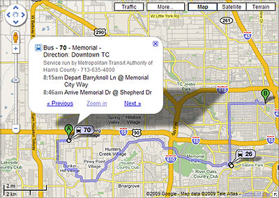
It’s now a whole lot easier to figure out how to get around Houston using public transit: Metro routes have at last been embedded in Google Maps. Which means if you use Google to plan a local trip, figuring out how to get there by bus or rail is now as simple as choosing “By public transit” from a dropdown menu. Schedule info is right there too.
So far, the public transit option shows up whenever you use Google Maps to get directions in Houston — or you can start from a separate Google Transit gateway here. Not yet activated for Houston: Google’s Transit Layer, which in other cities lets you see all the routes at once.
Even more convenient: If you can get Google Maps on your mobile phone, you now have access to bus and train directions and schedules there too. Here’s a video demonstrating how that works:
Today’s as good a day as any to highlight the work of YouTube user hcp051000, aka Senior Airman Pan, who has compiled an impressive array of videos documenting the performance of some of this city’s finer vertical conveyances.
What’s it like to ride in these Houston elevators, really? Now you can find out — and shop for your favorite — from behind the comfort of your own computer screen.
Here’s S.A. Pan’s ride in the colorful cab of a Dover elevator at the Kemah Boardwalk Inn Hotel:
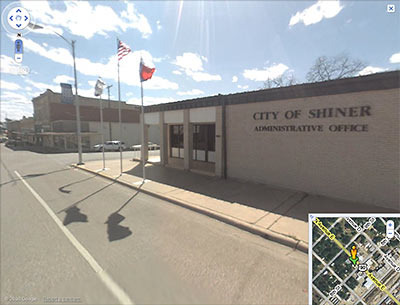
Earlier this week, Google greatly expanded the areas covered by its Street View feature. The expansion means street views in areas way outside of Houston and its surrounding areas are now viewable from within Google Maps. In fact, Google’s new coverage map indicates that pretty much all of Texas (or at least areas near its major roads and highways) now has navigable street images available, excepting a few patches here and there and a couple of wide swaths of land near El Paso.
What about the rest of the country? Oh, there’s some expanded coverage out there too:
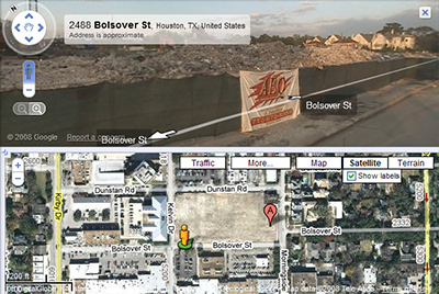
Google has rolled out another update to its Street View feature, this time allowing simultaneous views of a property from the air and the street — as shown in this view of a familiar Rice Village site. The button labeled “Street View” that used to sit at the top of most maps is gone. In its place: a character named Pegman who stands at the ready above the zoom slider on the left side of each map, and who narrates this video detailing the new Google Map features:
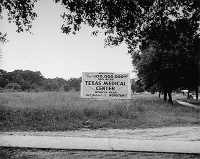
This 1946 Dmitri Kessel photo of some not-long-vacant Houston property is just one of a half-million images from the Life magazine photo archives that are now only a Google search away. Google is announcing that the entire collection of photos taken for Life magazine — about 10 million in all — will be available within the next few months. About 97 percent of these images have never been seen by the general public.
The images are available from a simple Google image search. You can single out the Life images by adding “source:life” to your search or by starting at this gateway.
Houston photophile Robert Kimberly, who’s been poring through the collection, says
There are loads of Houston pictures, but add “TX” or Texas” to narrow a search to the city. Otherwise you’ll be seeing lots of “Whitney.”
- LIFE Photo Archive available on Google Image Search [Google Blog]
- Google Hosting Time-Life Photo Archive, 10 Million Unpublished Images Now Live [Search Engine Land]
- Houston in Life Magazine: Online Photos Thanks to Google [Neon Poisoning]
Photo of sign advertising opening of Texas Medical Center, 1946: Dmitri Kessel, Life Magazine

Tired of looking at the same old images of Hurricane Ike devastation? Now, thanks to the amazing aerial camerawork of Dallas’s Hawkeye Media, you can conduct your own Bolivar Peninsula post-disaster flyover, focusing only on the destruction you want to see — from the comfort of your own broadband internet connection.
Hawkeye’s interface allows you to navigate through the company’s panoramic overhead views of wasted homes and newly desolate landscapes, zooming in and out as fast as your middle finger can scroll.
- Bolivar Peninsula [Hawkeye Media, via SciGuy, via Hair Balls]
Photo of Nelson Lane, Crystal Beach: Hawkeye Media
[youtube:http://www.youtube.com/watch?v=MngAUnhDDbg 400 330]
Metro says it is working with Google to add Houston’s public transportation info to Google Transit.
When will Google Transit for Houston be ready? “Sometime in November or December.”
- New York Gets New Transit Tool to Ease Commute Planning [Write on Metro, via Swamplot inbox]
- Plan a trip using public transportation [Google Maps]
- Transit on Google Maps [YouTube]

A company called U.S. Forensic has posted 1700 aerial photographs taken from a low-altitude airplane the company flew over southeastern Texas and Louisiana a few days after the hurricane. The photos are arranged in an overlay accessible through Google Earth, so you can import the file into the free software and search for views by address.
Even if you don’t use the Google Earth interface, the directory of individual photos provides some shocking scenes:

