COMMENT OF THE DAY: VIEWING THE PARK MEMORIAL CONDO POOL PARTY FROM THE AIR “On Google Earth’s time slider tool, the pool turns from a light aqua blue to a dark green pea soup between Jan. 2008 and Sept. 2008.” [Superdave, commenting on The Park Memorial Condo Wildlife Refuge]
Online Resources
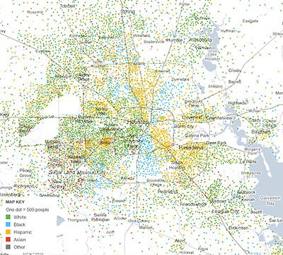
Remember those cool dot-by-dot renderings detailing the racial and ethnic distributions of 100 or so cities Swamplot featured a few months ago? Eric Fischer’s eye-opening map of Houston showed a city striped with different-colored pie-shaped wedges, but didn’t have much you could dig into. Working with data company Social Explorer, the New York Times website now has a version that displays much the same information, but it’s interactive, and allows you to zoom in on individual Census tracts. The “Mapping America” project covers the entire country and allows exploration of other metrics related to ethnicity, housing and families, income and education. Nothing’s included from the 2010 Census yet, though: the data comes the Census Bureau’s annual American Community Survey through 2009.
A few notable Houston-area snapshots include this map to same-sex couples:
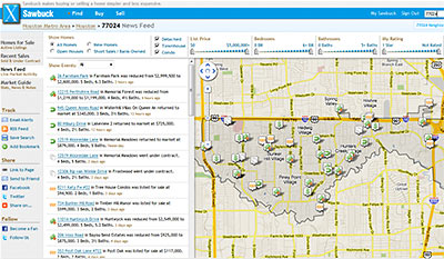
The website of upstart real-estate start-up Sawbuck Realty has a little something that anyone researching the Houston housing market might find helpful: the prices properties actually sold for. Well, at least the ones recorded in the MLS in the last year. Sale prices aren’t ordinarily made public in Texas — it’s a non-disclosure state. Instead, that info is hoarded by the keepers of the MLS, who now share it with a few appraisal districts but otherwise do their best to keep it out of the hands of consumers. But a 2008 settlement between Justice Dept. and the National Association of Realtors allows “virtual office websites” the same access to MLS data as regular brokers. That’s Sawbuck’s in: “When a user registers on our site they are establishing a relationship with us so we’re able to show them more information than just a standard public facing website,” explains Sawbuck’s Chewy Redding.

If you’d ever noticed that Google’s Street View feature is completely blacked out in the northern part of River Oaks and just presumed that your inability to see online images of all those fancy houses in Tall Timbers had something to do with their residents’ wealth, access to lawyers, or private security services, your presumption is wrong — or so says the Chronicle‘s Dwight Silverman, after a Google spokesperson sets him straight. Apparently the River Oaks gap in the Street View map is “just an oversight” on Google’s part:
I asked Google spokesperson Deanna Yick about this, and after checking in with the Street View team, she said this part of River Oaks simply hasn’t been imaged yet. She said Google eventually plans to fill in all the gaps in Street View “as soon as possible”.
She also said Google’s Street View cars will take pictures on any public street, and whole neighborhoods or communities can’t opt out of the process. However, individuals “can ask for images of their house, car or themselves to be removed from Street View,” she said.
Swamplot first noted the Street View black hole north of San Felipe and west of Kirby in 2008. Since then, Google has added a loop of coverage on Willowick and Inwood. But to see street-level images of the rest of that area, you’ll need to drive, pedal, or walk through the neighborhood on your own.
- River Oaks is a black hole on Google Street View [TechBlog]
- Google Maps coverage [Swamplot]
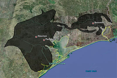
Playing around with a super-fun online tool that lets you superimpose the blobbish outline of the 2500-sq.-mile (and growing!) Gulf of Mexico oil slick from the Deepwater Horizon offshore-rig disaster onto various cities, Houstonist editor Marc Brubaker tries it on Houston — for size.
“It’s almost creepy how the slick follows I-10 out to Beaumont,” he comments. Of course, Brubaker should have nudged the oily blob a bit more to the east. Sure, he might have lost a few of those shiny exploration-company offices that have fled to the western stretches of Katy that way, but you’d be picking up lots of fun storage tanks and chug-chugging industrial plants at the northern reaches of Galveston Bay, and you’d get better coverage of Texas City, too.
Oh — but the outline is only up to date as of May 6th? Maybe we’ve got full coverage by now, then!
- Slicky Situation: The Deepwater Horizon Spill’s Actual Size [Houstonist]
- How big is the Deepwater Horizon oil spill? [Paul Rademacher]
Image: Houstonist

Hometta’s Ann Chou has an answer for all of you Swamplot readers still wondering about those bizarre arm motions one of its characters was making in the promo video for H-Town, the online small-home plan-sales company’s new virtual environment. She was just — you know — chatting!
Amid the feedback on last Friday’s release of the H-Town preview has been a seemingly recurring question. “um – what is that lady in the kitchen doing?” asked a commenter on ArchDaily. Over at Swamplot, someone described the lady in the kitchen as a “humanoid” that “has taken to some sort of repetitive carrot cutting activity with a roll of drawings (presumably architectural drawings).”
They are indeed architectural drawings belonging to our architect avatar, the firstborn in a cast of characters from which you will choose when H-Town goes live. Then, you too will be able to gush with your fellow avatars about 48′ House’s U-shaped kitchen!
So that’s how you gush in H-Town?
From online small-house-plan hawkers Hometta comes this video preview of H-Town, a virtual neighborhood where versions of the company’s modern home designs (several of which are from Houston architects) will always be open for visitors. If the preview bears more than a passing resemblance to Second Life, that’s because it uses OpenSimulator — an open-source Second Life-like 3D environment simulator.
H-Town isn’t modeled on Houston, explains Hometta’s Ann Chou — the H stands for Hometta. The small island features sidewalks, roads, a plaza, a gallery, and a market for Hometta’s small line of “Etc.” products the company also sells plans for, such as Collaborative DesignWorks’ 3×3 storage system:
And now, from Swamplot’s “tips” line, a reader’s brief personal testimonial for the Houston Service Helpline:
Seems like the folks who read your blog are motivated and want the best for the city (whatever that means to them). You can call 3-1-1 or (713) 837-0311 or my preference is the “web intake form” – clunky, but thorough. They send you e-mail with incident #, so you can call a representative and follow up. There are drop-down menus to request the type of service you want.
I’ve used the Houston 3-1-1 system a couple of dozen times to report:
- Stray pit bull
- Potholes (city is VERY responsive – normally fixed within 1 or 2 weeks, sometimes a day or two) They forward pothole/right-of-way concerns about freeways and frontage roads to TX-DOT, I think. For example, I called in several potholes on stretch of 59 frontage road near Lakewood. Within 10 days there were temporary asphalt patches (in concrete roadway). Within 3 weeks these had been cut out and replaced with concrete patches!
- Streetlights burnt out (very quick) or always on (not as quick) – I believe they forward these requests to Reliant or Centerpoint – all you need is the 6-digit # on the side of the pole
- Faded/worn off lane stripes and intersection markings @ westpark and weslyan – repainted within 6 weeks
- Broken water main under street – slow fix
- Replace speed limit sign that had fallen down – took 2-3 tries
Ladies and Gentlemen, start your modeling engines! Google’s “please create a 3D model of this city for us” project, Building Maker, has come to Houston. To do the bidding of your Google masters, of course, you’ll need to download and install the Google Earth plugin for your browser.
- Building Maker: Create 3D buildings online [Google]
- New Building Maker Cities [Google Earth Blog]
- Building Maker in 8 more cities and 25 new languages [SketchUp Blog]
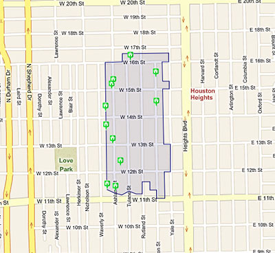
Houston’s 15 “please wait 90 days before demolishing” historic districts — plus that special one that’s a little more strict — now have their own special page on HAR.com. And it comes with maps! It’s now easy to stake out the boundaries of each one, if you’re into that sort of thing. And each map shows properties for sale within the district.
But the information doesn’t appear to be flowing in the reverse direction. Listings for properties located in historic districts still include no indication what district they’re in — or even that they’re in one at all. Unless, of course, the agent is forthcoming enough to mention it in the main text of the listing itself.
The Greater Houston Preservation Alliance also reports that “if a designated landmark is located within a historic district, the designation will appear on the site.” Anyone wanna show us some examples?
- Houston Historic Districts [HAR]
- Greater Houston Preservation Alliance [Facebook, via Swamplot inbox]
Image showing map of Houston Heights West Historic District: HAR
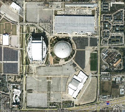
Swamplot reader Superdave, a self-proclaimed “Google Earth junkie,” is grooving on the program’s recently extended time travel feature:
In the most recent update of the free software, they added a feature where you can view aerial images from previous years, which is cool. At first they only went back 5 years or so. However, today I noticed that they’ve added imagery from December 1978 for nearly the entire Houston area.
I was numbstruck as I zoomed around and realized how substantially different this city is after our rampant growth over the past 30 years. I even got kind of sentimental seeing all those rice fields out west, where I grew up. I also felt a conflicted sense of relief that we’re in an economic downturn that will kind of apply the brakes (I’m sick, I know).
How’d the area around the Astrodome look 30 years ago?
WHAZZAT BUILDING? THERE’S AN APP FOR THAT Got a shiny new iPhone for Christmas? HAIF founder Wayne Lorentz wants help testing a new mobile interface for Towrs, his online architecture database. It’s not exactly an application, but it should be just as easy to use: “[It] uses the iPhone’s geolocation feature to display the interesting, historic, and significant buildings near where the user is standing. Downtown Houston and Galveston are two of the areas it is designed for. It also works well in Chicago, Los Angeles, Tokyo, London, and a few other cities. . . . All you have to do is point the iPhone’s browser to Towrs.com and it should just work.” Send feedback to editor@houstonarchitecture.com. [Swamplot inbox]
Thanks to the reader who passed along this flyover video showing what a fat, happy, and rebuilt Highway 290 will look like as it wraps its newly grown tentacles around Beltway 8. The video comes from TxDOT’s fancy new my290.com website, which attempts to bring to the planned multi-billion-dollar highway widening program the feel-good vibe of a community barnraising. When construction begins in 2011, will we be able to follow the construction workers as they tweet?
The site features current maps and details of the plans for US 290 and the Hempstead Tollway. Notes the reader: “Looks like the NW mall is history, well, at least most of the parking lot.” Here’s a view:

Realizing that Modern house fans may want a little gingerbread of their own this season, local online small-houseplan hawker Hometta is offering detailed instructions on how to bake a mostly edible version of the Draft House, a 3-bedroom, 2-bath model designed by the half-Houston-based HouMinn Practice. And the construction documents for this very small house are . . . free! Among the ingredients: dry mixes and peppermint sticks from the Whole Foods gingerbread chalet kit.
If you like how the sample goes together, plans for a full-size, non-edible version of the Draft House are available from Hometta too. But they’re gonna cost you.
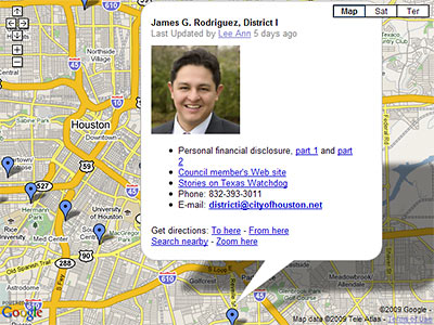
Texas Watchdog has released an interactive map that links to the financial disclosure statements of Houston’s city council members, including Mayor White. Each disclosure, which covers calendar year 2008, includes an accounting of real estate holdings by officials and their spouses — along with the usual stocks and bonds and mutual funds and business interests stuff.
Unfortunately, the map itself appears to note only the council members’ primary residences — not any strip centers, spec McMansions, apartment complexes, land grants, or tool sheds that might be lurking in their portfolios. For those goodies (if any), you’ll need to poke through the linked personal financial statements.
The statements, which state law requires council members to complete, are broken into 2 segments; real estate holdings are listed at the end of the first. Of course, for the more sophisticated investors in the City Council crowd, the more interesting properties are likely to be held under the name of some sort of business entity — like, say M/A Khan Holdings LP. You’ll find that sort of info in part 2.

