COMMENT OF THE DAY: PARKING LOT CITY “The mass produced and affordable automobile is the single greatest invention of all time. I’m happy to live in a city specifically designed [to] accommodate them.” [Bernard, commenting on Headlines: Trash in the Bayous, All the Surface Parking Downtown]
Transportation
NOBODY WANTS TO CRUISE FROM BAYPORT  How’s that effort to bring some actual cruise business — or really, any kind of business — to the Bayport Cruise Terminal going? Not so well. After contacting more than a dozen cruise operators last October, the port authority got no responses. The last and only departures made from the $81 million Pasadena facility, which opened in 2008: a couple of Carnival Cruise Ships shut out of Galveston for a short time after Hurricane Ike. [Bay Area Citizen] Photo: Commercial Care Services
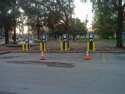
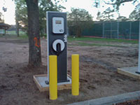 A reader who happened upon an outing of Blink stations at Memorial Park sends in this photo evidence that the commercial electric-vehicle chargers are multiplying. Two Blink stations at the nearby Houston Arboretum had been installed by the September 8th rollout of a city-wide drive-electric program. A total of 200 Blink-brand stations are being installed in the Houston area.
- ECOtality Announces the Expansion of The EV Project into Houston [Ecotality]
- Previously on Swamplot: More Jolts from Buffalo Grille Coffee, Houston EV Incentives: Free Jolt for Your Volt, Toll Relief for Your Leaf, Wired To Drive: Where Houston’s New Electric Vehicle Charging Stations Will Go
Photo: Swamplot inbox
SHHHH ON THE TRACKS! FIRST WARD WINTER ST. QUIET ZONE ARRIVES IN 2 WEEKS 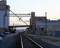 Approvals all in, construction and signage complete, a “quiet zone” for the Union Pacific rail line that runs along Winter St. in the First Ward will go into effect on September 27th, after the end of a 21-day waiting period. Several years in the making, the zone will prohibit freight-train engineers from blasting their horns at grade crossings — unless something or someone is on the tracks in front of them. Not included in the loud-horn ban, reports the Washington Quiet Zone team, responsible for getting the quiet zone on Washington between Sherwin and National streets in place last year: the southernmost track running through the First Ward, which carries about 25 percent of area freight traffic. Adding that track to the new Winter St. zone may take several more years. [Washington Quiet Zone; previously on Swamplot] Photo: Sarah Fleming [license]
THE 5 PLACES IN HOUSTON WHERE YOU’RE MOST LIKELY TO RUN INTO PEDESTRIANS The intersections of Milam and Dallas, Milam and Prairie, and San Jacinto and Congress St. Downtown; Westheimer and McCue near the Galleria; and Bellaire and Corporate Dr. just inside Beltway 8 in Asiatown rank as the top locations for auto-pedestrian accidents, according to a Chronicle review of city records. A grand total of 2,204 collisions involving cars and people traveling on foot have taken place in Houston since 2008, resulting in a total of 174 pedestrian deaths. The deaths were concentrated differently, “along the U.S. Highway 59 corridor near West Park and along Interstate 45 North and I-10 East,” with 43 percent of them taking place on freeways or major highways. [Houston Chronicle]
LONELY AT THE TOP Metro president George Greanias will receive a “more stringent punishment” than normal for his first-time offense: viewing “sites of a sexual nature” on his personal computer, using the transit agency’s internet connection. Board chairman Gilbert Garcia praised Greanias’s performance in improving “transit services, morale, and community relations” in his 15 months on the job but said “the community must have confidence that the New Metro will be open and transparent.” Greanias will be suspended from his job for the next week without pay. [Hair Balls]
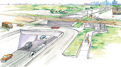
Harrisburg Blvd. and the East End light-rail line Metro is building along it will dip under the Union Pacific East Belt freight rail line between the future Altic and Cesar Chavez stations, Mayor Parker announced today. The city has committed $20.6 million of “existing money” to the build the underpass — in part by delaying other area improvement projects. The alternative, a longer freeway-style overpass, was opposed by many area residents and businesses.
- We have found the funding for an underpass and City of Houston has committed $20.6 million to put part of the East End Metro line underground. [Twitter]
- East End residents fight plan for Metro rail overpass [Houston Chronicle]
Drawing: City of Houston
If you can’t wait just those few more years to hop on the new light-rail line serving the East End, this automotive video approximation might tide you over. HAIF poster ricco67’s tracing of the drivable portions of the route from the new Smith St. station on the western edge of Downtown (shared with the new Southeast Line) to the Magnolia Transit Center provides snapshots of construction progress and a steady diet of orange construction barrels. Also available: these shorter tours showing progress on the Southeast Line and the coming extension to the existing North Line:
WHITE OAK BAYOU BIKE BYPASS IMPASSE What’s preventing the Houston Parks Board from connecting the end of the MKT Bike Trail in Timbergrove Manor with the White Oak Bayou Trail to create a continuous 14-mile route, and giving Oak Forest residents a path to stroll or roll all the way Downtown? Well, there are these 5 tracts of land in “a key section” in the 3/4-mile gap between Lawrence Park and T.C. Jester Park, project manager Trent Rondo tells Greg Densmore: “. . . of the five property owners tied to those tracts, four were working with the Parks Board while the fifth ‘was being a little feisty’ and was not yet ready to negotiate.” [The Leader, via Swamplot commenter KS; previously on Swamplot]
FULL SPEED AHEAD ON THE GRAND PARKWAY, WITH EXXONMOBIL AT 12 O’CLOCK A 12.1-mile segment of Houston’s newest and largest ring road, connecting the new ExxonMobil campus to the Tomball Parkway — and eventually to Katy — should be open by 2015, says the executive director of the Grand Parkway Association. TxDOT should start acquiring rights of way along Segment F-2 between Hwy. 249 and I-45 later this year, and construction will likely begin within 2 years, David Gornet tells Nancy Sarnoff. [Houston Chronicle; more info]
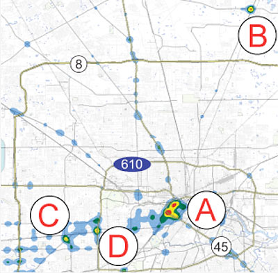
 Texas Watchdog crunched 2009 car-crash data from TXDOT to find the parts of town where wrecks were concentrated. The heatmap above resulted from plotting location information from almost 100,000 Harris County incidents, most of which included exact coordinates. The winners? Two separate sections of Downtown and the intersection of FM 1960 and Hwy. 59 north, near Deerbrook Mall. (One of those Downtown hotspots, centered on Metro’s Main St. headquarters, includes the Pierce Elevated.) Also noteworthy spots for wreckage buffs: 2 sections of the Southwest Freeway — one at the West Loop and the other at Hillcroft.
Downtown also topped Texas Watchdog’s separate breakdowns for accidents involving road rage and collisions involving cellphones. But second- and third-place winners in these categories produced more local champions: Westheimer at Hillcroft, the Galleria area, and 59 at Kirby all ranked highly as sites for road-rage incidents. For cellphone-related accidents, the top areas were Montrose, an area just south of the Galleria and southwest of the 610-59 interchange; and the route from the Johnson Space Center to I-45. The northeastern corner of the 610 Loop at Liberty Rd. won the fatality division outright.
Map showing wreck concentrations: Jennifer Peebles/Texas Watchdog
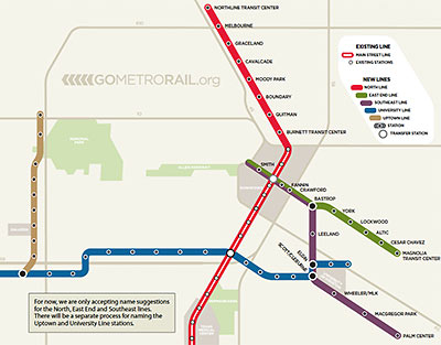
See that map up there, showing all the stations on Metro’s planned light-rail lines? Metro is asking the public for help naming those stations. But not the stations that don’t have any names indicated next to them — the transit agency isn’t quite yet ready to get to those. No, Metro wants your help choosing names for the stations that are already marked with names. Like, the “Burnett Transit Center.” What should that station be named? Anyone? Anyone? And how about the one marked “Boundary”? Any suggestions? Spicoli?
This is, of course, the best kind of call for submissions. If you can do better than what they’ve already got, go ahead! If you can’t beat what’s there already, why bother? And you can get an idea what the fallback is gonna be, if all the suggestions suck. Just think what we might have ended up calling East Downtown if that naming “contest” had been pitched like this: Yeah, we’re threatening to name this area EaDo — unless you stop us, with something better. How well would that have worked?
You can get a sense of where the stations are planned for the new North, East End, and Southeast Lines from these maps:
THE AIRPORT DIRECT SHUTTLE’S LONG GOODBYE After a ride on Metro’s newly discounted but still cold-as-a-meat-locker Downtown-to-IAH shuttle, Texas Watchdog reporter Steve Miller hears from an Airport Direct staffer just how last-ditch an effort last month’s price cut was. The new $4.50 one-way fare has increased revenue only slightly, the staffer reports, “but it will have to do more or the plug will be pulled in June.” In less-direct language, a Metro spokesperson backs up that statement. [Texas Watchdog; previously on Swamplot]

Has Metro ever made a more expensive mistake than spending $42 million on a contract with a Spanish rail-car construction firm that violated federal procurement rules? Now that the American subsidiary of Construcciones y Auxiliar de Ferrocarriles has agreed to return $14 million of that money, the answer is yes: That would be the $41 million Houston’s transit agency reports it spent on developing an intermodal terminal at the corner of Main and Burnett streets just north of Downtown. Metro CEO George Greanias confirms the agency has given up on the design (above), which would have included a giant octopus-like dome, bus bays, a commuter rail terminal, a “kiss-and-ride” area, and maybe a Metro RideStore, restrooms, newsstands, food stands, and gift shops. There will still be a Burnett Transit Center station with a North Line rail stop, but Greanias tells the Chronicle‘s Chris Moran the trashed design would have been too expensive to run. Metro may have even killed the bus station part: Greanias says they haven’t decided whether any other modes of transit will connect to the light-rail line at that location.
- Metro admits it blew a large fortune [Houston Chronicle]
- Intermodal Terminal Frequently Asked Questions
- Previously on Swamplot: Main St. Intermodal Transit Center Kiss-Off, On the Shelf: That Grand North Main Intermodal Center
- Previously on Swamplot: Houston’s Next Light Rail Lines Delayed Until 2014, Feds To Metro: Back off the Spanish Trains and We’ll Fund Your North and Southeast Lines
$4.50 FROM DOWNTOWN TO THE AIRPORT That shuttle service Metro’s been running from Downtown to IAH just got a whole lot cheaper — and added a few stops on the way. The Airport Direct service used to leave from the transit center at 815 Pierce St. with maybe one or 2 passengers a trip and cost $15 one-way ($10 if you could show a valid plane ticket). As of yesterday, the ride now costs $4.50, but stops also at the Main St. Square station and the Four Seasons, Hyatt, and Hilton Americas hotels before heading up the freeway. The transit agency has been losing $1.5 million a year on the every-30-minute service since it was introduced more than 2 years ago. [Houston Chronicle]

