12/27/16 5:00pm

Carvana vending machine, 10939 Katy Fwy., Memorial, Houston, 77079

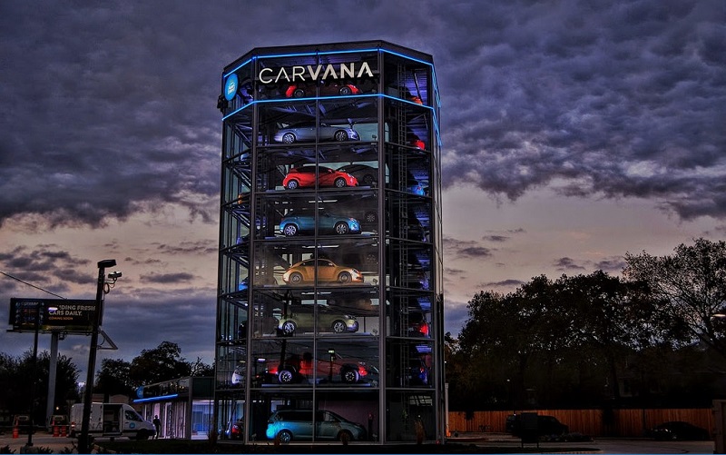
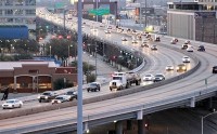
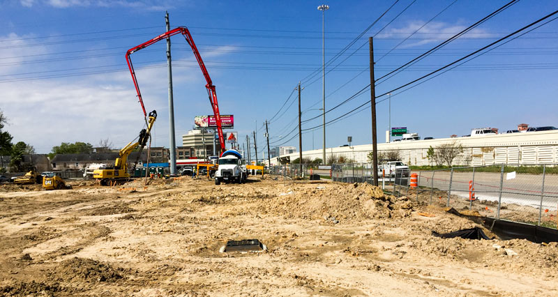
Along with starting up service at the new 8-story glass car dispensation machine on the former Big Tex Tree Nursery lot on I-10 this month, Carvana has released a bit of drone footage of the new facility (shown above). It doesn’t show the tower in action (though a video of a coin-triggered run-through of the original Nashville machine, which boasts only 5 stories of car-storage tower space, can be found here). The fly-by does show off some new grassy parking lot landscaping and the billboard that Carvana leased out to explain themselves, as well as a few of the residences on Lasso Ln. directly behind the machine. (That’s the east-bound Katy Fwy. on the left, with the flying ramps of Beltway 8 visible in the early morning haze.)

Photo of Carvana facility at 10939 Katy Fwy.: elnina via Swamplot Flickr Pool

Video: Carvana

I-10 Stackup
10/14/16 11:00am

FINDING CHEAP HOMES AT THE 20 MILE COMMUTER SWEET SPOT southwest-freewayData type Scott Davis tells Paul Takahashi this week that the average commute distance among Houstonians with a $265,000 home is 30.5 miles, according to his company’s real-estate database. The middle 2 thirds of that price group makes a slog of anywhere between 15 and 47 miles to get to work; Davis says some folks in that range drive as far as 60 miles. He does note to Takahashi, however, that the homes closer in — say, within 15 or 20 miles of a major employment hub — tend to sell much faster; HAR even rolled out a tool last year to allow searches for housing by commute time. [HBJ] Photo: Russell Hancock via Swamplot Flickr Pool

09/21/16 11:30am

1810 Gray St., Midtown, Houston, 77003

Some execution-ready excavator glamour shots next to 1810 Gray St. come from Fred Ghabriel, who snapped them yesterday evening in preparation for this morning’s underway demo of the space. The freestanding 1960s not-quite-under-the-freeway retail spot southwest of the junction of 59 and 45  is survived by some of its blockmates: the Citgo facing the Hamilton side of the block, and the Webster-and-Chenevert-facing double-decker strip center at 2117 Chenevert (home of Abacus Bail Bonds, Chase Shoe Shine Parlor, Heights Cleaners & Alterations, and nightclub Indigo at Midtown). The retail strip also contains an office of Bejjani & Associates, which owns the Gray-facing building currently under deconstruction (and with which Ghabriel is associated).

The structure at 1810 is getting cleared out for more parking for the center; the freed-up spots might get a touch of seasonal afternoon shade from the 3-sided billboard planted next to them, as seen in the now-moot leasing flier for the space:

CONTINUE READING THIS STORY

The Teardown Blues
09/12/16 5:15pm

COMMENT OF THE DAY: SNIFFING OUT FREEWAY BILLBOARD FINANCE CATCH-22S Redo of 3618 Burlington St., Westmoreland Historic District, Houston, 77006“I wonder what the particulate pollution is outside and inside of this house during various times of day and year? I wonder if one side of the house gets dirtier and needs pressure washing sooner than other, or if there is uniform pollution around the house? I guess its better not to know these things, because that might lower the potential value and an cause an acknowledgement of some salient dangers. I, personally, would think less about the highway if the sign were gone. [But] I guess the income from the sign could fund your HSA account and pay for all the inhalers you might need to alleviate your pollution-caused asthma.”  [Duston, commenting on Poolside Freeway Billboard Comes Down As Westmoreland Queen Anne Redo Wraps Up] Photo of partially deconstructed billboard by Spur 527: Swamplot inbox

08/04/16 4:30pm

THE ODDS ON A PIERCE ELEVATED COMEDOWN Map of Proposed I-45 Rerouting, Downtown HoustonWriting in the latest issue of Texas Architect magazine — which is now debuting a redone website with a new web address and a new all-articles-are-now free policy — Ben Koush surveys the prospects for the raised section of I-45 now dividing Midtown from Downtown: “While there have been some plans floated around to convert the decommissioned section of the Pierce Elevated into Houston’s version of the Highline, most people I spoke with didn’t think that was going to happen, simply because TxDOT needs the money it could get from selling that right of way to private developers. Some still hold out hope that at least some of the land or maybe even a small section of the elevated roadway could be made into a public green space.” [Texas Architect; previously on Swamplot] Plan of “currently approved scheme” for I-45 rerouting around downtown, showing possible green space: SWA Group

05/13/16 10:15am

This week’s video release from hometown country singer Robert Ellis takes viewers on a forlorn wandering tour of Houston’s downtown and surrounding thoroughfares, sans all of those pesky people and cars. Iconic cameos include the AIA’s future headquarters on the corner of Franklin and Commerce streets, the WALD warehouse sign at Live Oak and Rusk streets, and Bad News Bar on Main St.; the video also includes a hike down a dead-empty I-45 and associated entrance ramps, several frantic light-rail stops, and a dramatic reunion on the pedestrian bridge over Memorial Dr. at Sabine St. 

Video: Robert Ellis

Musical Background
05/03/16 1:00pm

Proposed Changes to Major Thoroughfare Plan near 290 beyond Grand Pkwy.

If you missed yesterday’s meeting in Hockley, you have until Wednesday to send Harris County your thoughts on the map above, from the official county study of road network expansion proposed between I-10 and 290 west of the Grand Pkwy. The thick red dashes mark a proposed loop road circling around almost the entirety of the Katy Prairie Conservancy‘s land preserve (shown as the darkest green blocks, amid slightly-grayer-green agricultural/undeveloped land and a few kelly-green public parks). Purple dashes show the proposed routes of new or expanded thoroughfares, some of which cut through the preserve and cross through the Cypress Creek floodway (shown as a blue underlay making a rough U through the conservancy’s land).

Further west (marked in blue dashes) is the not-yet-planned-but-still-showing-up-in-planning-maps route of Houston’s proposed outer-outer-outer loop, SH 36A (formerly nicknamed the Prairie Parkway). The map above also includes overlays of Harris County’s future development predictions, with dark taupe showing existing development and slightly lighter taupe showing expected expansion.

For comparison, here’s the Katy Prairie Conservancy’s map of west Houston; currently developed areas are marked in gray, the organization’s protected areas are marked in green, and the dashed green band shows how far the prairie ecosystem used to extend:

CONTINUE READING THIS STORY

Up the Watershed
04/12/16 2:30pm

COMMENT OF THE DAY: TAKE CARE OF THE OTHER BURIALS BEFORE PUTTING I-45 IN THE GROUND I-45 and 59 Proposed Tunnel
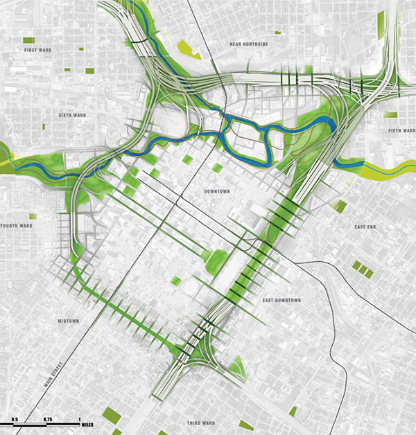
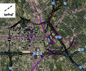
“I don’t understand why people want to bury the Pierce Elevated. That seems like something to put onto the table after all the murders are solved and money starts to rain down from the sky. Can someone explain this to me? How could it possibly be practical to tear down this road?” [Commenter7, commenting on Defending the Pierce Elevated; The First Toucan Traffic Signal in Texas] Illustration: Lulu

03/21/16 2:45pm

COMMENT OF THE DAY: THOSE I-45 EXPRESS LANE PLANS ARE CUTE NOW BUT JUST WAIT UNTIL THEY GROW UP pierce-street-45-downtown“Fine with these updates, provided the Pierce [Elevated] still gets torn down. Express lanes might seem like a good idea, but they’ll most likely be hindered by limited ingress/egress and often shunpiked. I’d imagine they’ll also be pretty expensive owing to the proposed modifications to the design. It’s a good design if you’re trying to center transportation around private auto use, but at some point, that can’t be the primary design consideration anymore.” [TMR, commenting on What Happens When You Decide To Redo That Downtown Freeway Plan in Your Spare Time] Photo of Pierce Elevated: Russell Hancock

03/18/16 4:30pm

WHAT HAPPENS WHEN YOU DECIDE TO REDO THAT DOWNTOWN FREEWAY PLAN IN YOUR SPARE TIME Purple City Freeway Plan Map captureTory Gattis reports in an update to his weekly column that TxDOT is looking over the alternative Downtown freeway plan put forth by Houston-based blog Purple City last week — to see if it can pull any ideas from it. The report, created by a semi-anonymous Houston-based engineer, includes detailed schematics, along with contextualized critiques of TxDOT’s most recently publicized version of plans to rework the interchanges of I-10, I-45, and 59 around Downtown. The Purple City plan appears to have a lot to offer: It would keep the Pierce Elevated as managed express lanes, while exploring options to make its street level pedestrian- and development-friendly. The alternative plan would require less right-of-way acquisition than TxDOT’s and eliminate left-hand exits. There are also bits about developing a new bus rapid transit line between Bellaire and UH, adding a a parallel bikeway network, and expanding the Downtown street grid. The 13-page report is available here; there’s also a scaled schematic of the entire plan. [Houston Strategies; Purple City; previously on Swamplot] Aerial schematic of (rotated) Downtown freeway alternative proposal: Purple City

03/02/16 5:00pm

Carvana Vending Machine construction site, 10939 Katy Fwy., Memorial, Houston, 77079

Carvana has confirmed that the work going on now at the former Big Tex Tree Nursery lot at 10939 Katy Fwy. is setup for the giant car vending machine referenced in September bid documents labeled with the site’s address. Building permits issued in January were applied for under the name of largely-non-digital used-car chain DriveTime, an investor in the Phoenix-based startup that also allows Carvana to borrow facilities to prepare vehicles for sale.

The new vending machine could be the first in Texas; Carvana opened a vending machine in Nashville last November, and also has a pickup site in Atlanta for those who don’t want to deal with delivery service. A reader sends some fresh shots of the action at the site, as well as a glimpse at a building plan:

CONTINUE READING THIS STORY

Going Digital on I-10
02/24/16 1:00pm

Update, 3/2: A Carvana spokesperson has confirmed to Swamplot that the company’s first Houston vending machine will be located at 10939 Katy Fwy. This story has been updated.

Online car dealership Carvana appears to have been planning to place a multi-story robotic car delivery system on the I-10-side lot that Big Tex Tree Nursery vacated after the December holidays wrapped up. A reader notes some construction bid documentation dating from September listing a project for the company at the 10939 Katy Fwy. address: The documents show a search for construction contractors for a ‘car vending machine’, scoped to involve multi-level car storage and an automated lift to bring vehicles down to the 1st floor on command.

But it looks like those plans fell through — at least as far as the location on the former Big Tex lot. Permits were issued last month to non-digital car dealer chain DriveTime for construction of a new sales building on the site. DriveTime currently has 4 locations around the Houston area, including one further west on the Katy Fwy. past Highway 6.

Carvana plugged in its first vending machine in Nashville last November, after jumping into the Houston market in October. The above video shows the Tennessee machine in action: cars are shuffled down from their glassy perch after users place a Carvana token into a coin slot.

CONTINUE READING THIS STORY

Pick Up or Delivery
02/12/16 3:00pm

COMMENT OF THE DAY: A DIFFERENT APPROACH TO THE FUTURE OF DOWNTOWN APPROACHES Cars in TrafficAn alternative that I would heartily recommend would be to work on nearby crosstown routes that may serve to relieve pressure on downtown-area freeways. Those would also be expensive and controversial, but also they are the low-hanging fruit; for example running a toll facility along the north-south Union Pacific ROW. Or completing SH 35 and then creating individually-tolled grade separations from there up Scott St. or Lockwood. OST is a very good candidate for this, as is the N. Shepard/Durham corridor. Do anything possible to speed up thru-traffic along Bayous by removing signalized intersections, especially along the Braeswoods, the T.C. Jesters, and of course Memorial Dr. and Allen Pkwy. These are all things that we would want to have around later on during the course of construction, anyway — but also, decentralized improvements have the advantage of being less subject to economic obsolescence resulting from…say driverless cars and rideshares…which place a big question mark on the near-term utility of mega-projects that required perhaps a decade to finish.” [TheNiche, commenting on TxDOT’s Plans for Freeway Expansion Around and Below the Newly Protected Cheek-Neal Coffee Building] Illustration: Lulu

02/11/16 4:45pm

SOME HELPFUL TIPS FOR PLACING A PARK ON TOP OF AN UNDERGROUND FREEWAY Meanwhile, in Dallas: What goes into the equation to span a park across a multi-lane underground freeway tunnel, as TXDoT’s latest updates on the planned I-45 redo suggest might be possible? Planning for Klyde Warren Park, which covers an underground section of the Woodall Rogers Freeway between I-35 and I-45 at the edge of downtown Dallas, had to take into account everything from the weight of hundreds of thousands of feet of fill, potential damage to structural elements from root systems, anticipated visitor weight, and all the other little projects that private donors wanted to add. Project coordinators also faced mid-project fire code changes, limited freeway closure allowances for construction, and a $16.7-million funding shortfall that was eventually closed by 2009’s Recovery and Reinvestment Act. The park officially opened in 2012 with a concert headlined by Trombone Shorty and the Polyphonic Spree. [D Magazine, Klyde Warren Park]

02/11/16 1:30pm

COMMENT OF THE DAY: MAKING A U-TURN ON REROUTING I-45 I-45 and 59 Proposed Tunnel“I was for this reroute plan early on initially, but as time has gone by I’ve grown against it. This massive freeway is going to ruin an up-and-coming scene happening currently in EaDo, all for the sake of meshing Midtown/Downtown. The best alternative is to tunnel the Pierce underneath its current route. It’s the least destructive and will make all parties happiest I.M.O. And don’t give me this crap excuse that nothing can be underground here because of floods. If everything is supposedly so ‘big’ here in Texas, then please think bigger when it comes to this project.” [Eddie, commenting on TxDOT’s Plans for Freeway Expansion Around and Below the Newly Protected Cheek-Neal Coffee Building] Illustration: Lulu