COMMENT OF THE DAY: A BETTER WAY TO TELL IF YOUR HOME IS GOING TO FLOOD  “My neighborhood flooded in Allison in 2001, and then again on Monday night. I can’t tell you how many ‘so much for the 100-year flood plain‘ comments I heard walking up and down the street.
What it really means is that it is a flood (or more properly a storm, or my favorite, ‘rain event’) that has a 1% chance of happening every year. So what that really means is that if you live in the ‘100 year flood plain’ you have a 26% chance of flooding during your 30 year note. And for many of these areas the 100-year storm on which these maps are based have 100 years or less of accurate rainfall data.
A better rule of thumb is to remember: (1) if you live near a bayou and it rains A LOT, you will probably flood at some point. (2) if it’s raining A LOT and the road you are on dips below the grade of the adjacent roads, it’s probably going to flood and (3) if it’s raining A LOT where you are in Houston, you can count on it flooding.” [Txcon, commenting on That Place on I-45 North of Downtown Where the Cars Always Seem To Hang Out After It Floods] Illustration: Lulu
“My neighborhood flooded in Allison in 2001, and then again on Monday night. I can’t tell you how many ‘so much for the 100-year flood plain‘ comments I heard walking up and down the street.
What it really means is that it is a flood (or more properly a storm, or my favorite, ‘rain event’) that has a 1% chance of happening every year. So what that really means is that if you live in the ‘100 year flood plain’ you have a 26% chance of flooding during your 30 year note. And for many of these areas the 100-year storm on which these maps are based have 100 years or less of accurate rainfall data.
A better rule of thumb is to remember: (1) if you live near a bayou and it rains A LOT, you will probably flood at some point. (2) if it’s raining A LOT and the road you are on dips below the grade of the adjacent roads, it’s probably going to flood and (3) if it’s raining A LOT where you are in Houston, you can count on it flooding.” [Txcon, commenting on That Place on I-45 North of Downtown Where the Cars Always Seem To Hang Out After It Floods] Illustration: Lulu
Sign up for the Newsletter
Tag: Bayous and Waterways

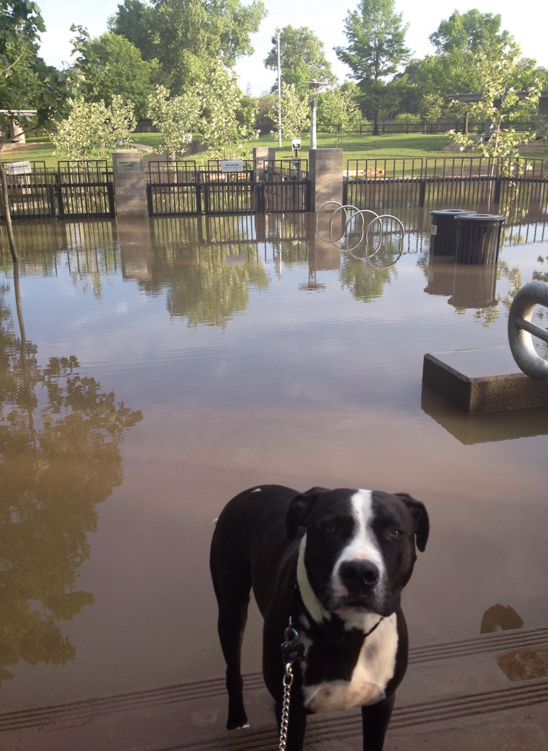
No Buffalo Bayou Park fun this morning for Swamplot coverdog Kep, on account of the whole Johnny Steele Dog Park at the intersection of Studemont and Allen Pkwy. is flooded after yesterday’s downpours. Which is what a bayou-side park is expected to do during and after weather like yesterday’s.
More pics of the scene:
When Buffalo Bayou Spreads

COMMENT OF THE DAY: WHY THE WATER IN YOUR NATURALLY FILTERED BAYOU-SIDE SWIMMING HOLE IS GOING TO BE BROWN  “I’ll bite. Here’s a very simple engineering analysis.
Problems with stream-fed swimming pools in Houston are going to be three-fold:
1) Silt (in engineer-speak, Total-Suspended-Solids or TSS). TSS is treated with sedimentation basins. That can be a large pool (that people don’t swim in) adjacent to the real pool. In water/wastewater treatment plants, a coagulant like alum is usually added to sedimentation basins to make TSS precipitate out quicker. If you’re going to do this with no chemicals, you’ve got to be willing to accept either VERY long treatment times, or only partially successful results. The tiny diameter of the clay particles that make up the TSS in our bayous just flat out won’t come out of suspension without a coagulant, so the water WILL be brown. It’s not necessarily a deal breaker — the water in Galveston’s brown too.
2) Bacteria (in engineer-speak, total coliform count). See here. Usually these are E. Coli, algae, and some protests. ALL streams/lakes/oceans in the entire world have this, even the cleanest and clearest. Realistically, to get an insurance policy to operate, the water’s going to have to be disinfected to some degree. That means chlorination (chemicals), ozonation (chemicals), or UV disinfection. More on UV in a minute.
3) Dissolved oxygen content. You don’t want the water to turn anaerobic. If there’s enough carbon-containing compounds dissolved in the water, the bacteria naturally in the water will eat it rapidly, causing the bacteria to use up all the oxygen that’s already dissolved in the water. This leads to any/all fish in the water suddenly dying off, as well as noxious smells and other really terrible stuff. You can make sure the dissolved oxygen doesn’t drop by filtering out carbon containing compounds (takes chemicals), or using aerators. A dual-way to solve the #2 and #3 issues is by passing the water over a very shallow (less than 6-in. deep) bed of rocks at a fast speed. Think rapids. This lets the water simultaneously re-oxygenate and also absorb huge amounts of UV. This might be the sort of silver bullet that makes this possible in Houston.
So: This is going to be expensive, but it’s probably do-able. However, the water is still going to be brown. Sorry.” [Ornlu, commenting on Bayou Swimming Hole Promoters Jump To Kickstarter To Jumpstart Project] Illustration: Houston Needs a Swimming Hole
“I’ll bite. Here’s a very simple engineering analysis.
Problems with stream-fed swimming pools in Houston are going to be three-fold:
1) Silt (in engineer-speak, Total-Suspended-Solids or TSS). TSS is treated with sedimentation basins. That can be a large pool (that people don’t swim in) adjacent to the real pool. In water/wastewater treatment plants, a coagulant like alum is usually added to sedimentation basins to make TSS precipitate out quicker. If you’re going to do this with no chemicals, you’ve got to be willing to accept either VERY long treatment times, or only partially successful results. The tiny diameter of the clay particles that make up the TSS in our bayous just flat out won’t come out of suspension without a coagulant, so the water WILL be brown. It’s not necessarily a deal breaker — the water in Galveston’s brown too.
2) Bacteria (in engineer-speak, total coliform count). See here. Usually these are E. Coli, algae, and some protests. ALL streams/lakes/oceans in the entire world have this, even the cleanest and clearest. Realistically, to get an insurance policy to operate, the water’s going to have to be disinfected to some degree. That means chlorination (chemicals), ozonation (chemicals), or UV disinfection. More on UV in a minute.
3) Dissolved oxygen content. You don’t want the water to turn anaerobic. If there’s enough carbon-containing compounds dissolved in the water, the bacteria naturally in the water will eat it rapidly, causing the bacteria to use up all the oxygen that’s already dissolved in the water. This leads to any/all fish in the water suddenly dying off, as well as noxious smells and other really terrible stuff. You can make sure the dissolved oxygen doesn’t drop by filtering out carbon containing compounds (takes chemicals), or using aerators. A dual-way to solve the #2 and #3 issues is by passing the water over a very shallow (less than 6-in. deep) bed of rocks at a fast speed. Think rapids. This lets the water simultaneously re-oxygenate and also absorb huge amounts of UV. This might be the sort of silver bullet that makes this possible in Houston.
So: This is going to be expensive, but it’s probably do-able. However, the water is still going to be brown. Sorry.” [Ornlu, commenting on Bayou Swimming Hole Promoters Jump To Kickstarter To Jumpstart Project] Illustration: Houston Needs a Swimming Hole

BAYOU SWIMMING HOLE PROMOTERS JUMP TO KICKSTARTER TO JUMPSTART PROJECT  Just how feasible would it be to build a 3-acre self-cleaning swimming hole somewhere near the center of Houston, so you could take your own bathing-suits-and-skyscrapers pics like the one shown here — without resorting to Photoshop? If enough people donate to the Kickstarter for the Houston Needs a Swimming Hole campaign, you may get to find out. Promoters Monte Large, Evan O’Neil, and Jeff Kaplan are hoping to raise $30,000 from contributors for a feasibility study for their proposal — including a preliminary site selection component. The study would be conducted by Sherwood Design Engineers, whose Houston branch is a tenant in office space connected to Kaplan’s New Living store on Kirby Dr. The swimming hole, meant to serve as a centerpiece of Houston’s growing our-bayous-are-our-parks system, would be patterned on the natural swimming pool model common in Europe, where adjacent plant-filled “regeneration zones” filter the water, and no chemicals are needed. [Kickstarter; more info] Photo: Houston Needs a Swimming Hole

How long has it been since you’ve run along, rowed along, or flown over Buffalo Bayou? Guy-out-with-his-Phantom-quadcopter Marco Luzuriaga filmed this scene earlier this month above a short section of the city’s most prominent drainage canal beginning near the Rosemont Bridge, then turning around and heading a ways toward Downtown. He gives up on the waterway and substitutes a bit of downtown-tangling freeway spaghetti near the end, but if you look into the distance around the 1:30 mark, you can catch a quick progress report on reconstruction of Buffalo Bayou Park.
Video: Marco Luzuriaga, via Brittanie Shey
Tour by Drone

How is it that Kyle Naegeli is able to catch so many fish — including bluegills, bass, and catfish — simply by dropping lines into the storm-sewer inlet at the intersection of Carnation St. and Camilia Ct. in Katy? Well, the now-16-year-old has had 4 years of practice fishing in the same sewer, for one thing — as attested to by the many videos demonstrating his more recent exploits, available on his YouTube channel. (His latest bass catch — demonstrating Naegeli’s well-honed long-arm grab technique — is shown above.)
And it doesn’t hurt that the same inlet drains directly into a large pond south of Bartlett Rd. and behind the houses on Carnation St. — where Naegeli regularly fishes as well, and the bass are jumping:
The Fishing Channel
COMMENT OF THE DAY: WHAT COUNTS AS A SPRING IN HOUSTON  “The definition of a ‘spring’ can vary a lot, and is used loosely here.
In Harris County, where the topography is relatively flat, most of our ‘ponds’ and ‘lakes’ are either borrow pits (excavated to raise the grade elsewhere) or dammed-up gullies/ravines along existing bayous. In this case, it is the latter — a gully of Buffalo Bayou that was dammed up, then developed into a neighborhood.
A ‘spring’ is generally a point where the top groundwater table meets the surface. In our area, when we receive a lot of rain, the groundwater table can actually reach the surface. So a spring can range from a trickle of water to a puddle standing on the surface. When I dug the post holes in my backyard for my cedar fence, I hit groundwater at 2 feet deep because of recent heavy rain. In dryer periods, the water table drops, and springs continue to occur along steep cuts in the topography (either along a bayou that has eroded downward, or a man-made excavation). This is not what you find in the Hill Country, where large gaping holes in limestone spew thousands of gallons per hour, sometimes creating rivers out of nothing.
So effectively, any hole in Houston greater than 2 feet deep at some point will become ‘spring-fed.’ During the bad drought of the past few years, most likely the groundwater table dropped and stopped feeding this former gully of the bayou, and the ‘lake’ was most likely topped off by (1) automatic sprinkler runoff and (2) the small amount of storm water runoff they received, as the lake also serves as the neighborhood drainage ditch.” [Superdave, commenting on There’s a Tour of Texas and More in a Developer’s Lakefront Sandalwood Spread] Illustration: Lulu
“The definition of a ‘spring’ can vary a lot, and is used loosely here.
In Harris County, where the topography is relatively flat, most of our ‘ponds’ and ‘lakes’ are either borrow pits (excavated to raise the grade elsewhere) or dammed-up gullies/ravines along existing bayous. In this case, it is the latter — a gully of Buffalo Bayou that was dammed up, then developed into a neighborhood.
A ‘spring’ is generally a point where the top groundwater table meets the surface. In our area, when we receive a lot of rain, the groundwater table can actually reach the surface. So a spring can range from a trickle of water to a puddle standing on the surface. When I dug the post holes in my backyard for my cedar fence, I hit groundwater at 2 feet deep because of recent heavy rain. In dryer periods, the water table drops, and springs continue to occur along steep cuts in the topography (either along a bayou that has eroded downward, or a man-made excavation). This is not what you find in the Hill Country, where large gaping holes in limestone spew thousands of gallons per hour, sometimes creating rivers out of nothing.
So effectively, any hole in Houston greater than 2 feet deep at some point will become ‘spring-fed.’ During the bad drought of the past few years, most likely the groundwater table dropped and stopped feeding this former gully of the bayou, and the ‘lake’ was most likely topped off by (1) automatic sprinkler runoff and (2) the small amount of storm water runoff they received, as the lake also serves as the neighborhood drainage ditch.” [Superdave, commenting on There’s a Tour of Texas and More in a Developer’s Lakefront Sandalwood Spread] Illustration: Lulu

YES, YOU’VE BEEN SIPPING WHAT DALLAS HAS BEEN FLUSHING 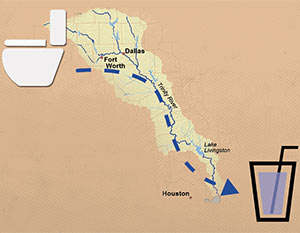 “For the large chunk of population that lives downstream from a big city and whose water supply flows through a river, more than a few drops of the water in their glasses was probably once in someone else’s toilet,” Neena Satija drily notes in her reassuring survey for the Texas Tribune of sewage-treatment projects throughout the state. Her story is worth checking out for the animated image diagramming the flow from a Fort Worth-area toilet to a Houston highball glass alone (excerpted screenshot shown at left, above), but she does stir up some oft-repeated local poop: “Let’s start with Houston, which, as Texas State University professor Andy Sansom says, ‘has been drinking Dallas’ crap for decades,’” she writes. “Wastewater from Dallas and Fort Worth is deposited into the Trinity River, where it flows down into the lakes that supply Houston residents. The wastewater is so clean that it’s credited with helping the Trinity River stay strong during recent years of severe drought.” [Texas Tribune; previously on Swamplot] Illustration: Todd Wiseman/Alessandro Suraci/Luis Prado

A spokesman says the Houston Police Department has “long been aware” of most of the 127 vehicles Texas Equusearch found submerged in Houston bayous back in 2011, when the nonprofit search-and-rescue organization used a sonar-equipped boat to hunt for the rented car of an elderly woman who had gone missing. But until Equusearch went public with the data this week, it appears no one from law enforcement had bothered to bring the rusting cars and trucks to the attention of environmental organizations, families of missing persons, wrecker drivers, classic-car collectors and restorers, bayou boaters, noodlers, or other groups that might have wanted to know.
No matter, now: Above, courtesy of Texas Equusearch and the Houston Chronicle, is an interactive map identifying the coordinates and descriptions of the vehicles — including at least one full big rig — that have been gently rusting at or near the bottom of Brays and Sims Bayous for at least 2 and a half years. The Chronicle data appears to exclude the half-dozen or so transportation options Equusearch searchers found beneath the waters of the relatively un-trafficked Buffalo Bayou. But you can spot some of them in the upper portion of this screen capture published with Joel Eisenbaum’s original report for KPRC of a similar map:
Submerged Bayou Secrets

COMMENT OF THE DAY: HOW ABOUT A RAIL LINE ALONG THE BAYOU?  “I always thought a line down Memorial Drive along Buffalo Bayou would be awesome. It seems like it would be pretty easy to adapt the stretch of Memorial from downtown to Shepherd in to a rail friendly street — there are pedestrian crosswalks already, abundant lanes, and no stop-light intersections to contend with. They could take a lane or 2 from Memorial Drive, make a new right of way down the park, or even make an elevated line (which all of them should have been). The stops could tie in with cross streets or some the existing pedestrian bridges. This could be a real ‘showcase’ line for the city being right next to what seems to becoming Houston’s prime inner city park location. The line could continue all the way into Memorial Park and maybe even somehow get to the Galleria.
And of course Swamplot is the best forum for me to lobby my vision.” [actualarch, commenting on What’s the Point of Metro’s New Buffalo Bayou Bridge Under I-45?] Illustration: Lulu
“I always thought a line down Memorial Drive along Buffalo Bayou would be awesome. It seems like it would be pretty easy to adapt the stretch of Memorial from downtown to Shepherd in to a rail friendly street — there are pedestrian crosswalks already, abundant lanes, and no stop-light intersections to contend with. They could take a lane or 2 from Memorial Drive, make a new right of way down the park, or even make an elevated line (which all of them should have been). The stops could tie in with cross streets or some the existing pedestrian bridges. This could be a real ‘showcase’ line for the city being right next to what seems to becoming Houston’s prime inner city park location. The line could continue all the way into Memorial Park and maybe even somehow get to the Galleria.
And of course Swamplot is the best forum for me to lobby my vision.” [actualarch, commenting on What’s the Point of Metro’s New Buffalo Bayou Bridge Under I-45?] Illustration: Lulu

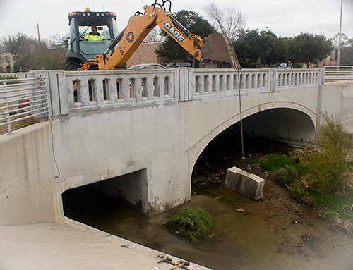
 . . . Well, at least as long as Brays Bayou is able to handle whatever rains come. Late last month, an excavator (pictured above) yanked out the last piece of a 3-year-old 6-ft.-by-6-ft. concrete panel used as a “restrictor” and meant to make sure rainwater that fell in West U stayed in West U for a good long time. The restrictor (shown in place blocking the right side of the drainage channel pictured at left) had been put in place by the Harris County Flood Control District after West U, working with the city of Southside Place and Metro, completed $8 million worth of drainage improvements in 2010 on the colorfully named Poor Farm Ditch, which drains along the east side of Edloe St. through much of West University and further south to Brays Bayou. Those improvements had been meant to solve West U’s frequent flooding problems. But without some place for the water to go, that solution for West U might have caused flooding elsewhere downstream. So the district placed the restrictor on Poor Farm Ditch on the south side of the Edloe St. bridge across Holcombe St. — until the city could somehow come up with 13.5 acre-ft. of flood detention to hold the runoff.
With flood improvements completed but the restrictor still causing water to back up on Poor Farm Ditch, West U flooded again in January 2012 after a hard rain.
The Rich Floodwaters of Poor Farm Ditch

WHERE THE POOP IS, IN AND AROUND LAKE HOUSTON  “While some Houston bayous, such as Buffalo and White Oak, have bacteria levels seven times higher than Lake Houston’s watershed, the waters flowing from the San Jacinto River are more vital, said Steve Hupp, Bayou Preservation Association spokesman. . . . Houston’s drinking water is pumped from an area of the lake not contaminated with bacteria.
Only the northwest corner of the lake is impaired, records show. This segment runs from where the river intersects Spring Creek, winds through Humble and past the Kingwood golf course, and ends at the West Lake Houston Parkway bridge.
The bacteria level found in the lake segment exceeds the state standard of 126 E. coli per 100 milliliters of water by 100 percent. Levels on both the river’s west or east forks are lower — exceeding the standard by 25 percent to 56 percent, depending on the segment. Yet a small tributary, Crystal Creek, which feeds into the west fork, has the highest count. It exceeds the state standard by 168 percent.
The communities along the San Jacinto watershed are experiencing a boom in development, especially around the river’s west fork in Montgomery County. Exxon Mobil already has a new 385-acre corporate campus that will be home to 10,000 workers under construction there, while the Boy Scouts recently sold their nearby 2,175-acre camp to a master-planned community developer for a reported $60 million.” [Houston Chronicle ($)] Photo of Lake Houston: Sara Robertson (license)
“While some Houston bayous, such as Buffalo and White Oak, have bacteria levels seven times higher than Lake Houston’s watershed, the waters flowing from the San Jacinto River are more vital, said Steve Hupp, Bayou Preservation Association spokesman. . . . Houston’s drinking water is pumped from an area of the lake not contaminated with bacteria.
Only the northwest corner of the lake is impaired, records show. This segment runs from where the river intersects Spring Creek, winds through Humble and past the Kingwood golf course, and ends at the West Lake Houston Parkway bridge.
The bacteria level found in the lake segment exceeds the state standard of 126 E. coli per 100 milliliters of water by 100 percent. Levels on both the river’s west or east forks are lower — exceeding the standard by 25 percent to 56 percent, depending on the segment. Yet a small tributary, Crystal Creek, which feeds into the west fork, has the highest count. It exceeds the state standard by 168 percent.
The communities along the San Jacinto watershed are experiencing a boom in development, especially around the river’s west fork in Montgomery County. Exxon Mobil already has a new 385-acre corporate campus that will be home to 10,000 workers under construction there, while the Boy Scouts recently sold their nearby 2,175-acre camp to a master-planned community developer for a reported $60 million.” [Houston Chronicle ($)] Photo of Lake Houston: Sara Robertson (license)

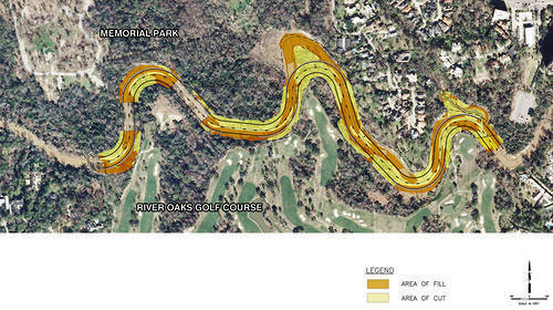
in this week’s Houston Press, writer Dianna Wray wades into the murky waters surrounding the Harris County Flood Control District’s plan to move and rebuild the banks of Buffalo Bayou where it winds between Memorial Park and the River Oaks Country Club. The method of “natural channel design” the district plans to use in the $6 million project is meant to keep the bayou in place, using downed trees instead of concrete. But weren’t bayous born to wiggle? “If the Army Corps of Engineers approves the Memorial Park Demonstration Project permit application,” Wray writes, “construction workers could move in by the end of this year, using heavy equipment and saws to reshape the bayou according to a pattern that should, if the method is successful, lock the waterway into a form it will hold for generations to come. If the effort fails, the entire project could be blown down the river by one heavy flood, leaving nothing but naked, unprotected soil where the last of an ancient forest once stood.”
- Fighting for Control: Can Buffalo Bayou Survive the Latest Plan to Save It? [Houston Press]
- Conservationists have an eye turned to Buffalo Bayou project [Houston Chronicle ($)]
- Memorial Park Demonstration Project [HCFCD]
Plan of Memorial Park Demonstration Project: Harris County Flood Control District
The Banks of River Oaks

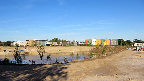
A reader sends in pics showing how construction is progressing on the 3 retention ponds along White Oak Bayou TxDOT is building between Yale and Shepherd — and hoping to trade them for any available updates about plans for the adjacent segment of the planned bayou-side path: “Looks like they are making progress with tree planting and installation of pavers on the slopes. They have left a wide swath of level ground around the entire perimeter. They are still doing earthwork on the north end, and it looks like they still need to excavate more soil from the center pond, but you can make your way around all three detention ponds.”
The photo at top shows the center pond (south of the bayou), looking northeast, with White Oak Bayou barely visible off to the lower right. Below, a view of the northernmost piece, Rutland Pond, a portion of which interrupts 6th St. (where the orange construction fencing is visible):
On Rutland Pond

")
And here, from a reader perched at the top level of MD Anderson’s Braeswood Garage at Braeswood Blvd. and Pressler St., are photos of the land- and tree-clearing going on for the new just-across-the-bayou-from-the-Med Center apartments that Mill Creek Residential is going ahead with — after abandoning plans for a slightly larger complex (as close as it could get to Dynamo Stadium without crossing Dowling) in East Downtown. The photos are taken looking south, over Brays Bayou; the TMC South Extension Lot is behind the site, which fronts Wyndale.
