12/08/16 2:00pm

Pedestrian Bridge over White Oak at Durham St.

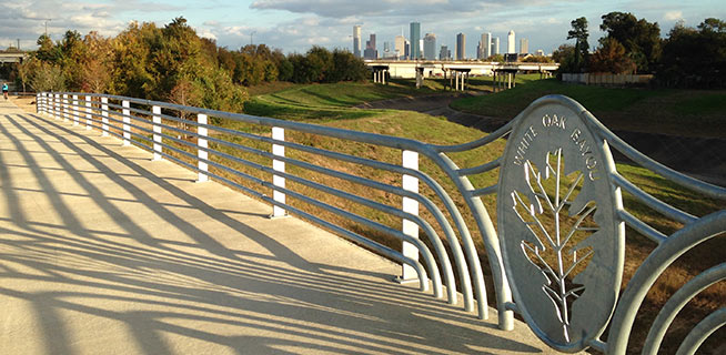
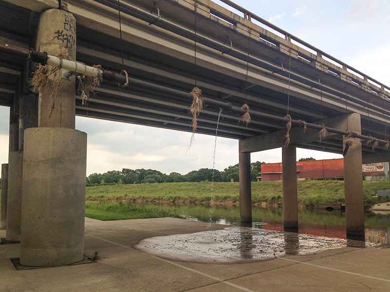
The section of bayou-hugging greenway trail running between Durham St. and Stude Park is getting the official OK tomorrow morning from Harris County Flood Control District and the Houston Parks Board. The photo above is of the pedestrian bridge across White Oak near Durham St. that previously supplanted the area’s “Bridge of Death” route; the segment opening tomorrow runs from that same bridge east along the bayou to the Studemont St. non-pedestrian bridge. The organizers are hoping would-be trail fans will use some means other than car to get to the ceremony location (off Studemont just north of I-10); if you have to drive, however, the invitation says you might be able to get a parking space across the freeway north of  Target.

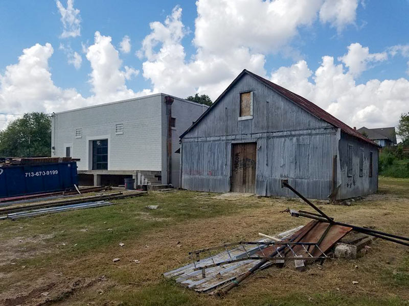
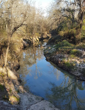
Further east along the White Oak trail, here’s an updated view of how that link into Near Northside by the Leonel Castillo Community Center is coming along (taken in mid-November, once again from the same spot as that glitzed-up flood photo that made an appearance in Air New Zealand’s recent in-flight feature on Texas):

CONTINUE READING THIS STORY

Greenways Growth Spurts
11/29/16 11:00am

San Jacinto River at I-10 Crossing, Channelview, TX 77530

Weather permitting, an area along the edge of the San Jacinto Waste Pits Superfund site under the I-10 East bridge should be getting around 800 cubic feet of new rocks piled onto it this week and next, according to this month’s EPA update on the project. The agency asked International Paper and McGinnis (which might be on the hook financially for much of the final cleanup) to cover up some recently-discovered areas of the nearby riverbed that were scoured as deep as 8 feet in some places by this spring‘s torrential flooding; the tarp-with-rocks-on-it armored cap itself doesn’t appear to have been damaged, but the EPA says the extra rocks will help ensure its continued protectiveness.

CONTINUE READING THIS STORY

Armor Under I-10
10/27/16 11:00am

210 Glen Park St., Near Northside, Houston, 77009

A few twists and turns up Little White Oak Bayou from N. Main St. and the White Oak Music Hall complex, work is underway on a bayou-side brewery on another piece of land owned by W2 development (and going by the name Black Page Brewing Co.) The city issued a few more permits for the brewpub this week (fast on the heels of the permit issued Tuesday for the music venue’s permanent outdoor stage — a few days after construction allegedly got rolling, though not quite in time for tonight’s planned outdoor The Head and The Heart concert). Owner Anthony Heins tells Swamplot the pub is just leasing the land from W2, which country records show bought the property in April of last year. And builder KUEHN Inc. has been snapping photos of progress at the former warehouse, which sits near the stretch of waterway where an area resident took those videos of chainsaw aftermath back in May; that area is down beyond the orange fencing below on the left:

CONTINUE READING THIS STORY

Near Northside Neighbors
09/29/16 2:45pm

San Jacinto River at I-10 Crossing, Channelview, TX 77530

Aerial View with Delineated San Jacinto Waste Pits Cap, I-10 at San Jacinto RiverYesterday the EPA released their recommendations for what to do about the toxic muck in the San Jacinto Waste Pits, after more than a decade of local and federal agencies poking and fishing around in the area (on either side of the I-10 crossing of the river). So far the Superfund site has been temporarily dealt with by the 2011 placement of a pretty-much-just-a-tarp-with-rocks-over-it armored cap, which the EPA says has already been repaired at least 7 times; the document released yesterday notes, however, that disturbances at the site caused by weather and previous nearby sand mining operations “could cause a catastrophic release of the highly toxic waste materials from the impoundments, if they remain in place.

The EPA wants to remove about 202,000 cubic yards of contaminated material (roughly enough to fill the floor of the Astrodome with a 13-foot-deep layer) but says it’ll have to be done carefully so as not to accidentally stir up the waste into the surrounding river while trying to get it out; the removal would also probably take place in stages to avoid potentially exposing too much of the waste at a time to storms or flooding. Here’s the EPA’s map of the 2 sites where the paper sludge was originally dumped in the 1960s — the (capped) northern area is outlined in blue and labeled Cap Site, while the southern site (outlined in yellow and labled Southern Impoundment) is covered in part by the Glendale Boatworks building, next to Southwest Shipyard:

CONTINUE READING THIS STORY

Not Keeping a Lid on It
08/18/16 1:00pm

Find Your Watershed map, 2016

This month the Galveston Bay Foundation and Houston Advanced Research Center released their second annual report card on the health of Galveston Bay, boiling down a wide range of measurements into a series of letter grades. The report card, which looks at the bay itself along with the bayous that drain into it, aims to be easy to understand for folks with or without scientific training. Each of the 6 main categories of grade — including subjects like wildlife population trends, pollution sources, and human health hazards — is broken down with explanations of what specific measurements that rating is based on (and more details in the full report, for those who want them).

The agencies have also put together a Find Your Watershed tool, which lets you check in on how your own part of town is affecting the bay’s GPA. (That’s Buffalo Bayou watershed’s report shown above; the bayou did exceptionally well in dissolved oxygen and nitrogen content this term, but failed wetlands.) You can look up any address and see how the surrounding runoff area measures up in some of the report’s subject categories. (Note that the search tool’s map doesn’t use the same color-by-grade scheme that the rest of the report employs — you’ll have to click on each watershed to see the actual marks).

So how did the bay do this year?

CONTINUE READING THIS STORY

Galveston Bay Schooling
07/14/16 2:30pm

COMMENT OF THE DAY: STRAIGHTENING OUT THE CONCRETE-LINED BAYOU PARADOX white-oak-bayou
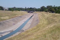
“While I am no run-off-water-channeling expert, I am under the impression that tossing out the concrete is not just for appearances. The concrete ditch moves the water faster than the natural channel, and can [thereby] actually aggravate flooding rather than cure it. Returning to the natural channel structure may mitigate flooding.” [Al, commenting on Might White Oak Bayou Ditch Its Concrete?] Photo of White Oak Bayou channel: Swamplot inbox

07/13/16 1:45pm

COMMENT OF THE DAY: ARE THE MONEY AND THE WATER FLOWING THE SAME DIRECTION? Demographic Map of Houston Census Blocks and Public Housing Projects, from Texas Housers“So I was looking at this the other day and a thought just hit me, based on a comment on another thread: Is this trend of gentrification following the bayous? Seems like that is a major draw to new development, and with the transition of the East End and Third Ward, it looks like a possibility.” [Mr.Clean19, commenting on A Purple Map of Race and Public Housing Projects in Houston] Map: Texas Housers

06/09/16 2:15pm

San Jacinto River at I-10 Crossing, Channelview, TX 77530

Aerial View with Delineated San Jacinto Waste Pits Cap, I-10 at San Jacinto RiverAnother effect of the Memorial Day weekend and early June floods: the EPA says it has had to pause some of its latest study efforts near the 1960s industrial waste pits in the San Jacinto river (shown at the top looking a bit more submerged than usual on May 31, facing north from the I-10 bridge). New rounds of sample-taking were triggered by the discovery in December that the Superfund site’s armored cap (which is made of special tarp material held down by a layer of rocks) had a 25-ft.-long hole where the rocks were missing. The EPA also notes that the damage was found within an area of the cap where no tarp was actually initially placed, in light of concerns that the rocks would slide off of it. 

CONTINUE READING THIS STORY

More Fun With Superfund
06/08/16 3:30pm

GROUP FORMS TO CLEAN UP THE UPPER SAN JACINTO BEFORE IT GETS AS BAD AS BRAYS, BUFFALO, SIMS BAYOUS West Fork of San Jacinto River, Montgomery County, TX  
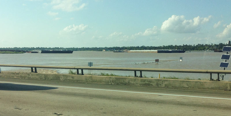
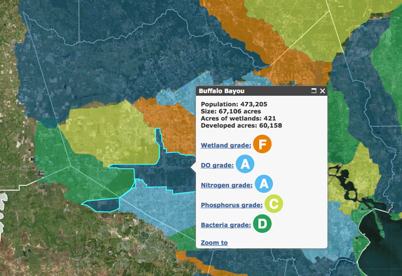
The West Fork of the San Jacinto River (implicated in much of the latest flooding between The Woodlands and Conroe) is in a bacterial “sweet spot”, environmental planner Justin Bower tells Matthew Tresaugue in the Houston Chronicle this week  — more contaminated than is acceptable, Bower says, “but not so much that we can’t do anything about it.” Tresaugue writes that E. coli levels have been trending upward since 2002, in some cases running as high as 10,000 colonies per 100 milliters of water (around 80 times higher than the 126-colony limit recommended by the state of Texas). The river’s water quality problems are multifaceted, but generally boil down to increased development in the watershed causing increased runoff that carries more junk — from human and animals waste to sediment from a nearby gravel mining operation — into the river and ultimately the Lake Houston reservoir (from which the city pulls drinking water). The newly formed West Fork Watershed Partnership has no definite plan yet (other than to work with area stakeholders to develop a plan). But Lisa Gonzalez (VP of the Houston Area Research Council) notes to Tresaugue that not doing anything could allow the West Fork’s water problems to get as bad as those of other major urban waterways in Houston. [Houston Chronicle; previously on Swamplot] Photo of West Fork of the San Jacinto: West Fork Watershed Partnership

02/09/16 10:30am

Vehicle Recovery for Operation Submerge, Gulfgate, Houston, 77023

If you are the owner of the bottom half of a red Ford Ranger left in Brays Bayou near Wayside Dr. some time in the last 20 years, your vehicle may be waiting for you in HPD’s impound lot. The pilot program intended to test out a procedure for fishing out the 127-or-so vehicles mapped beneath the surface of a few of Houston’s waterways reeled in its 20th and final car over the weekend before the $49,500 project grant ran out.

The removals started near the Wayside bridge over Brays Bayou in late January, then moved upstream of the crossing of Lidstone St. on the 29th; last Friday, operations jumped down to Sims Bayou to score a few final sets of wheels. Harris County Flood Control District, which oversaw the fishing trips, tweeted that project executives will now meet to discuss future removal plans and compare notes on the process, which involved divers from Saltwater Salvage submerging to attach giant yellow floaties to the sunken vehicles:

CONTINUE READING THIS STORY

Stirring Up Mud in Gulfgate
01/28/16 10:45am

Sunken Vehicle Removal from Brays Bayou at S. Wayside Dr., Gulfgate, Houston, 77023

A 1987 Buick Regal was pulled from Brays Bayou yesterday, as a $49,500 pilot program to remove about 127 vehicles thought to be sunk along the bottom of several of Houston’s major bayous revved up. Divers working at the crossing of S. Wayside Dr. attached bright yellow floaties to the sedan to help it swim to the surface before it was lifted onto the shore, where police identified it as reported stolen in 1998. Mike Talbott of the Harris County Flood Control District expects that crews will be able to remove some 20 to 25 cars before the money runs out.

The Buick is one of the drowned cars mapped by Texas Equusearch in 2011, as the nonprofit used a sonar-equipped boat to look for a missing woman in a Black Dodge Avenger (later found in a retention pond off Old Galveston Rd.). Assistant Chief Mark Curran of HPD told ABC 13 that most of the cars at the bottom of Brays and Sims Bayous were probably joyridden and then dumped. Stolen vehicles have been found in other Houston-area water bodies, including that 1985 Fiero uncovered in 2011 during the extended drought which brought down Lake Houston water levels.

Floating yellow containment booms spanned the waterway downstream of yesterday morning’s operation to catch any oil or gasoline that might leak from the vehicles during the removal process:

CONTINUE READING THIS STORY

Nice Catch Under Wayside Dr.
01/22/16 4:50pm

LARGEST OIL SPILL IN U.S. HISTORY WILL FUND GREENWAYS ON CLEAR CREEK Clear Creek Trash Cleanup
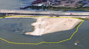
Money from the Gulf Coast Restoration Trust Fund, set up with part of the $18.7 billion BP paid last summer to settle with the federal government over the Deepwater Horizon oil spill, is making its way to Houston in the form of a $7.1 million grant supporting the Houston Parks Board’s Bayou Greenways 2020 project. Joe Martin of the HBJ reports that the money will be used to purchase and preserve parkland along the Clear Creek Greenway, which runs along Clear Creek from Missouri City to Clear Lake via Pearland, Friendswood, and League City. The 2020 plan calls for the cleanup and connection of greenspace along all of Houston’s major bayous. The 2012 RESTORE Act channels funds from the BP settlement into ecological restoration, economic development, and promotion of tourism in Texas and the other Gulf Coast states impacted by the spill, as well as scientific research on the Gulf of Mexico. [HBJ] Photo of Clear Creek annual trash cleanup: Clear Creek Environmental Foundation

01/19/16 4:30pm

Encampment removal at Louisiana St. and Congress Ave., Downtown, Houston, 77002

The encampment under Louisiana St. (shown above) was dismantled earlier today; a reader sends both now-you-see-it and now-you-don’t shots. The camp was previously tucked above the south bank of Buffalo Bayou, about halfway between Sesquicentennial Park and Allen’s Landing.

The removal appears to have been carried out by workers for Houston First, responsible for maintenance of public venues such as Miller Outdoor Theater and the George R. Brown Convention Center, along with a list of downtown parks that includes Sesquicentennial and the Sabine Promenade. Houston First also works on marketing and branding for the venues (and more generally for “the Houston product”) in partnership with the Greater Houston Convention & Visitors Bureau.

Here’s what the spot looked like after today’s clear-out:

CONTINUE READING THIS STORY

Gone Downtown
01/13/16 4:00pm

Renderings of Houston Botanic Garden at Glenbrook Park Golf Course, Glenbrook Valley, Houston, 77017

Bright and shiny renderings from the recently-released master plan for the Houston Botanic Garden show that design firm West 8 is aware of the challenges involved in straddling a world-class park across Sims Bayou, on the site of Glenbrook Park Golf Course just across I-45 north of Hobby Airport.  The Dutch firm, known internationally for unusual bridges and unconventional landscape design, has planned for many of the Garden’s displays to flood at will; the shores of Sims Bayou on the Garden’s property will also be resculpted. And to combat Houston’s just-shy-of-year-round heat, shade trees would be preserved or planted throughout the park, including the towering cypresses depicted in the bayou-side wetland gardens shown above (parts of which will be explorable by kayak).

Meanwhile, the more formal garden spaces planned for the park are shown with their own built-in shade (complete with custom ceiling fans): Colonnade structures (like the ones picture below) will ring each of the major collection gardens, which are designed to be “entered, enjoyed, and contemplated from the comfort of the shaded perimeter”:

CONTINUE READING THIS STORY

Glenbrook Valley Garden
06/04/15 5:00pm

Leaking Pipe Under Gulf Fwy. at Brays Bayou, Sylvan Dell, East End, Houston

There’s a busted pipe hanging under the Gulf Fwy. overpass as it crosses Brays Bayou, just east of Telephone Rd. and south of Idylwood in the East End. The pics shown here were taken late yesterday afternoon, though some sort of liquid had been seen dripping from the break at various points over the weekend.

Grassy remnants of last week’s high water on Brays Bayou can still be seen hanging from various points along the pipe’s length:

CONTINUE READING THIS STORY

Leftovers